


Snowman.
-
Posts
3,374 -
Joined
-
Last visited
Content Type
Forums
Blogs
Gallery
Events
Learn About Weather and Meteorology
Community guides
Posts posted by Snowman.
-
-
Pretty crazy however quickly the vortex falls appart towards the end, control going the same way too.
-
 3
3
-
-
While I believe we will suffer a period of Atlantic influence, my main focus is the block NE I can’t escape the possibility of around the 20th we will see high pressure develop NE which will likely calm our weather and cold and frosty conditions, the last 3rd of December will be have us glued to this forum. Let us hope for we don’t repeat a Dec 2021.
-
5
-
-
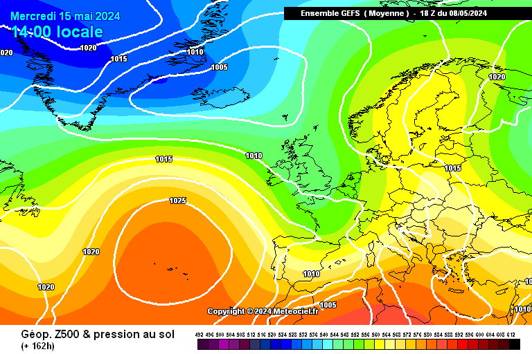
Mean 6z vs 0z

The wrap around heights to the north is very apparent, as the atlantic hits the block east it is throwing a ridge ahead, while that is likely to draw southerly winds it may lead to height building to the NE.
As this continues you can see heights to the NE "winning" out and the trough becomes more negatively aligned.
Not far off an Easterly at this moment. If I was to hedge a conservative bet, below is looking like where we could end up. Almost a stalemate nice block NE but not far enough west.
Now if we are lucky we need to see a ridge at around 120 mark we need see a vertically aligned trough building a ridge ahead of it.
is what we are after
horror show.
There are some absolute peaches in the ensembles, but rides or dies on how much amplficiation we can get earlier on.
-
3
-
 1
1
-
 1
1
-
-
Got a dusting here, still snowing!
-
1
-
-
We have snow! Settling with ease too!
-
1
-
-
-
8 minutes ago, BLAST FROM THE PAST said:
No, the ‘westerly’ pattern/Atlantic influence is nailed on imo. Just how that manifests itself and exact timing is still to be seen. It’s by no means set that December will be eaten up by it though, far from it….what we don’t want it this
fortunately it’s a GFS ‘hurricane’ so large pinch of salt. But the 00z had a deep storm around then….so something to keep an eye on re getting a named storm going forward.
BFTP
Make it 2. 940mb!
-
2
-
-
Heights are not properly locked around Greenland sending the pattern north-west.
However it will still be cold over the coming days, so enjoy that while you can and I have a feeling we won’t be waiting long for the next Chase to begin.
-
- Popular Post
- Popular Post
Give the ECM a few days and you'll be getting a long fetched Easerly, -10 uppers instability would grow the lot.
Exceptional run, one that would truly have me excited.
-
13
-
9 minutes ago, northwestsnow said:
UKMO
RAMP activated for Winter 2023
Lots of snow for the SE !!
About time...
Still think the lows are modelled a little too far north still, but time will tell.
-
2
-
-
Potential banger from the GFS here! Very cold air moving south from the north about to engage with a channel runner?
-
7
-
-
- Popular Post
- Popular Post
44 minutes ago, TauntonRoss said:Need to look at the bigger picture though, cold in place and the more reliable charts are trying to deepen the cold air, to me it looks cold right beyond next weekend, after that is a crystal ball kinda of weather forecast.
Like I said, the big picture doesn’t mean anything to anyone unless it starts snowing outside.
I’m all about the bigger picture, but unless it starts delivering what many here are after then it will just remain the bigger picture.
I live on the coast, in the south I know my chances. There is a reason why the M4 corridor is a net weather meme at this point because those south are told to think about the bigger picture and it will change when it gets closer, the models underestimate the cold uppers etc but yet in the middle of cold spell they get cold rain and not snow it doesn’t fill them with confidence.
The nature of our setup we’re potentially going into is much the same, some will get snow others will get rain. It’s just the winners and losers of a messy situation of the cold air meeting the mild air. While cold yes, unless it is snowing outside their house then they will see as a disappointment.
-
8
-
1
-
1
-
35 minutes ago, TauntonRoss said:
Hence why people need to chill, the charts will catch up.
I think many here are looking for snow, the problem with these types of charts that while yes we’re heading for colder than average but for many unless it is snowing outside they’re not going to be happy.
I believe this is where the frustration is coming from, decent synoptics but not cold enough to guarantee snow will fall.
As for the BBC, you’re better off following this thread for up to date information as they work on a lagging period.
-
5
-
2
-
-
Icon looking quite a bit different from other outputs later on, weaker Greenland high but further East.
-
22 minutes ago, Kasim Awan said:
We need to look for corrections South.
Indeed, we’re getting close and heights seem to be building a little stronger north every run and the feature a little weaker. But still would like a good shunt south.
-
ECM control is defo better. Interested to see how it evolves as the 0z wasn’t far off a great run.
-
2
-
-
Mean is a massive improvement early much weaker trough, less mixing and further south
vs
-
2
-
-
Enjoying the heights becoming stronger earlier on, at 168 we’re not far off straight line easterlies, a stronger high all allows for better CAA.
Another shunt S and a slightly east and we could be in -8s in no time.
-
1
-
1
-
-
11 minutes ago, winterof79 said:
UKMO is very pleasing to the eye.
If you enjoy rain maybe...

-
1
-
1
-
-
Really sorry to say but the UKMO this morning really isn’t great and would likely to leading to you needing a boat rather than a sledge. Luckily it seems relatively alone but you don’t want deep bowling ball lows like that. You want flat lows with the centre over the northern half of France.
Generally speaking if lows start phasing the West/SW of the UK that can spell trouble as it throws a ridge up in front which brings a southerly feed into the UK, the last thing you’re after when searching for cold and snow.
The shape you’re after is flat lows south, this allows for the greatest chance to advert cold air west.
-
2
-
-
- Popular Post
- Popular Post
No point over analysing OP runs in regards to uppers etc. when there is a whole load of water to flow under the bridge. Just be happy things are going in the correct direction.
-
9
-
1
-
2 minutes ago, sheikhy said:
Never seen it struggle this much, the difference between the 6z and 0z is crazy considering it’s within 72 hours!
The control looks great and primed at D7.
-
2
-
1
-
-
Stark changes on the ECM there, almost don’t believe it. UKMO to follow in the 12z surely??
-
2
-
-
EC and UKMO very much in the same ship at 144. The handling of the ejecting shortwave is now within the 3 day mark which is where there is a still a difference between the EC and GFS.
Wouldn’t bet against the EC in this case but it still doesn’t fill me with confidence.
-
1
-


Model Output Discussion - Into Winter
in Forecast Model Discussion
Posted · Edited by Snowman.
1 GEFS suite, but a jump from Westerly mean to NW'ly mean.