


Ventnor Viking
-
Posts
197 -
Joined
-
Last visited
Content Type
Forums
Blogs
Gallery
Events
Learn About Weather and Meteorology
Community guides
Posts posted by Ventnor Viking
-
-
We never tend to do well out of these northerlies. Im looking forward to the scandi high which is growing in confidence for mid to late December, where we have lows undercutting it. That's our best bet. Im still enjoying the showers we have had today and the event on Monday morning will be good for us. We need to make the most of that one though before it thaws away into Tuesday!
-
Just now, SteveB said:
Truly amazing watching the radar and seeing the showers over Wales disappearing as soon as the get near the Bristol Channel, Not one has made it across.
There is some beefy showers in Wales at the moment, surely they can make it across can't they

Unfortunately as soon as they hit the Brecon's and the Valleys they lose energy and dissipate. The Irish sea build the showers up and then the showers lose the strength over the colder high ground. Need a bit of heat somewhere to pep them up
-
 1
1
-
-
Here in Shaftesbury today we have had some snow showers which has given a dusting. I would forget Sundays snow event if you are south of north Wiltshire. Monday looks like a snow settling event for anyone 5 miles from the coast and with decent elevation
-
1
-
-
1 minute ago, Dorsetbred said:
If anywhere can SHAFTESBURY can..
You sit on my snowhope meter, as below
Shaftesbury Yeah, bound to
Blandford Hmmm Okish
Wimborne Hopeful
Broadstone Yep, almost there
Poole, OH YES, it's snowing..
Great description of Dorset snow chances and very accurate! I grew up in Poole and was so frustrated with snow prospects, Shaftesbury is a good spot for it. Although the charts are looking good even for Poole in the coming weeks
-
1
-
-
It looks as though at 210 GFS heights are diminishing and the polar energy groups are merging back together to possible start up the polar vortex.....of course 210 is about 80hrs to far forward to consider speculating about in these set ups......
-
Light snow forecast for Shaftesbury tonight at 2am
according to BBC weather......
-
2
-
-
42 minutes ago, swfc said:
Altho the 18z fails to deliver to the uk the actual nhp even at the latter end isn't at all bad.weak pv and still ok for November. The fact is the models are struggling with a pattern change ie greenland high or west based blocking.o suspect it will be a different scenario tom .hopefully our friend to the sw will sling his hook south east towards the med.interesting if frustrating times but beats long fetch sw winds and rampant pv !!!
Just to add, the models don't factor in the extremely low solar output we are experiencing (and will continue to do with the occasional little spike) along with an eastern phased QBO which in my opinion both of these will have a significant affect on our pattern into mid December onwards. The general trend for the foreseeable future is to see the Arctics stratospheric 30 hPa and 10 hPa temperatures to decline to below average over the coming days. (sorry cant attach any links at the moment - will post later!) which will strengthen the jet temporarily due the temperature deviation from the arctic to that of the mid(ish) latitudes i.e. the northern Atlantic.
-
1
-
-
Sleet also in Shaftesbury - Air is noticeably colder now to.
-
1
-
-
- Popular Post
I know this is a bit off topic, but it's currently snowing in Shaftesbury North Dorset. I think this just proves that we look so far into FI chasing charts we don't look at all the little changes and things happening alot closer to the time
-
11
-
Over the past few weeks a lot of end of year winter tension has been building and a few silly comments made - just think if everyone put a pound in for all the naughty words said at the models and too each other we could have all gone to Lapland and built snowmen together with good cheer.....anyway that's not the case.
The models are very turbulent at the moment, the ECM looks like the form horse to me. I think all models have been hinting at seeing colder conditions coming in and normally cold air is tough to budge and this is where we are likely to mild air and cold air battling with snow events taking place I for one love what each run can bring so lets all just chill (pun intended) wait for the fun to begin!
-
2
-
-
Just now, nick sussex said:
Unfortunately you need a trigger to get that jet angle, either a lot more amplification upstream or high pressure to the ne which helps to lock low pressure over central Europe. Neither look on the cards in the shorter term going off tonights outputs. We do need a very big shake up in the NH pattern otherwise we're going to be feeding off scraps.
Hi Nick,
I agree that we do need a trigger. However what is clear at the moment from the previous run is that both agree that a hit of unsettled weather is due but both don't agree on the HP situation as the HP on the 0z run is very different to that of the 12z. This indicates that there is a probable chance of some changes aloft as there as some quite big differences with regards to HP position from run to run.
-
3
-
-
The last 3 frames of the ECM this evening do have fairly cool to cold 850 hPa temps as seen below. There is a good chance of unsettled weather coming in towards the Christmas period. its definitely worth watching to see if the jet pushes further south and to see if the orientation moves to a more NW/SE then precipitation is more likely to start turning wintry.
-
4
-
-
3 minutes ago, fergieweather said:
Nobody (sensible) should be automatically equating the signals with snowmageddon (or lack of snow for that matter). The broad pointers are to a cold set-up. That is very clear. Issues re snow are a matter for much shorter lead times.
Absolutely, no doubt there will be snow in places however the wind direction will be key as to where will be affected, furthermore easterly winds can in fact be very dry
-
2
-
-
7 minutes ago, Orpingtoniceagedec10 said:
Which lake " the English Channel and Thames estuary"
Not the right set up unfortunately. There needs to be a deep cold pool moving from the east and a low pressure to unstable the atmosphere. very rare we get these types of set ups.
-
2 hours ago, IDO said:
Not really seeing anything unusually cold in the next 7 days. The trend looks to push the cold upper flow too far east for snow (nominal chance now) and still a small chance of a dry northerly. The high has been consistently modelled to sink SE and in this run it does. That high is not going to just sit there IMO as the models are not even entertaining that. The Azores then pushes in bringing milder air from around D9.
I see no upstream amplification to stop the mobility of the flow and there is absolutely no WAA worth its salt other than transient topplers. Very little potential showing up in the runs and unless the models flip soon its wait it out till mid-Dec.
At around D9 on the GEM and GEFS:
Mild more likely in the mid term with 14c after D10 possible with that Azores push.
We have a PV in disarray and there is just no forcing to take advantage of this, even if its just Rossby wave action to kick the strat PV; really a missed opportunity despite the potential further down the line. Thankfully the trop PV still showing no trend to regroup so maybe in a couple of weeks we will get some forcing but certainly zero consistent cold runs coming from the GFS and that is not good when so much is in our favour.
I agree, I think frost at night and if fog lingers during the day then it could minimise temps during the day but its surface cold which as I mentioned earlier isn't a reflection on the true atmospheric pattern as wind and orientation of the HP can dictate who sees the colder conditions.
-
2 minutes ago, karlos1983 said:
Wouldn't say upgrade just yet, but we have an opportunity now for upgrades. Lows pressure going south east and a building ridge. That's a good platform to build from
I think many in here are looking for cold. Under the HP there are chilly days ahead and frosty nights but nothing sustainable long term. Additionally its surface cold so wouldn't take much to shift all in all seasonable weather and more importantly for many it remains dry!
If its wintry weather all is after the HP is too weak to our SW and upstream patter doesn't allow for any ridge to build in a favourable position.
-
1
-
-
I appear to be the only one that doesn't see this as an upgrade?
-
1
-
-
1 minute ago, Paul said:
Some posts have been hidden, can we keep it both friendly, and model related please.
Hi Paul
Apologies no offence was intended I was merely being factual about how arctic ice could influence the atmosphere....
thanks
-
1
-
-
A mild GFS run today - I have to say the GFS has been in poor form lately with finding any consistency even to relatively short time frames. There are many things, as ive mentioned before, that the GFS cant forecast and isn't programmed to until fairly short notice like a SSW etc.
Im more intrigued by the Met Offices model as the models available to us are really struggling which is very tiring, that said Ill still be watching like a donut!!!
-
1
-
-
So many interesting charts tonight - don't forget this time yesterday for many winter was all ready over!
Interesting that GFS favours a Greenland block and ECM more of an easterly flow.
I think yesterday I mentioned the model are struggling big time at the moment but one thing I will say im confident that some cold charts will appear relatively quickly and not so much in FI. With so many situations that the models aren't really programmed to factor in like SSW, Solar and SST that are changing frequently sooner rather than later we will see something v interesting!
-
6
-
-
1 minute ago, booferking said:
There is one trend and it is around a weeks time the scandi high is getting closer. We just need the low to cut under.
I'd like to think that's a possibility but to be honest there is to much energy above to the north which forces the weakish HP to collapse away to the SE pretty quickly...
-
So the charts once again have no trends - we can comment on the charts being produced but no trends in FI to speak off which is positive that means the models have no clue for anything past 240h.
to summarise the waiting game continues............
-
2
-
-
I'm not getting caught up in the individual model runs at the moment - this really is an usual situation we are going through with regards to the stratosphere, the sea temps and the solar activity.
I don't think I've ever seen a strat warming start so early on, technically everything should be cooling right down now.
http://www.netweather.tv/index.cgi?action=stratosphere;sess=
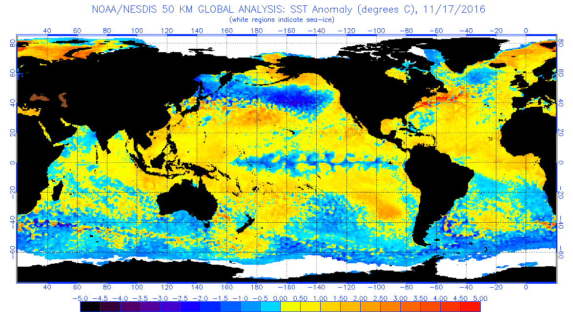
The sea and ocean temps have changed and have been changing recently,especially the pacific and north pacific. Looking back through I cant match a year with anything similar.
Solar activity continues to decline on a weekly basis (with the very occasional sun spot appearing but overall very week).
The latest image being very quiet for sun spot numbers!
My opinion is that the models cant get to grips with all these changes and the variances are very different to anything I've seen. My gut tells me that very soon we will see something very interesting appear out of the blue at shortish range and catch many of us out!
-
6
-
-
9 minutes ago, PerfectStorm said:
With respect to the posters here. I don't think models can be 'off' (or at least any given run), nor can they be wrong because they aren't showing us want 'we' want. The GFS can be right, it can show dross weather for weeks...it has happened before in the Winter, and I'm sure it will happen again. It's just a prediction, so there's absolutely no way we can say, "it's wrong, it will revert back to bla bla!"
Regardless of the fact that it's 16 days away, how can we be sure it will be wrong?
My reference to being "off" is nothing to do with wanting cold its more to do with the fact its been all over the place today with regards to positioning of the HPs. Once the 2 LPs over the next 4 days have passed through the models will then in my opinion show something more realisitic. The models trying to forecast deep LPs and blocking at the same will never be accurate to be honest.
So I stand by my the models have been a bit off today and by off I mean they are struggling to get grips with both scenarios although tomorrows low is probably on track now
-
2
-


 according to BBC weather......


.png.3ab289fa0d3021f120263d7802a36777.png)


South West and Central Southern England Regional Weather Discussion 09/12/2017 onwards
in Regional
Posted
Light sleet/wet snow in Shaftesbury at the moment