


Jemma Croton
-
Posts
177 -
Joined
-
Last visited
Content Type
Forums
Blogs
Gallery
Events
Learn About Weather and Meteorology
Community guides
Posts posted by Jemma Croton
-
-
- Popular Post
- Popular Post
14 minutes ago, Singularity said:
It's all connected; see how the major surge of relatively warm air over to Siberia becomes the origin point of the strong height rises there.
What this does mean, though, is that any interruptions to that warm surge could severely weaken or even negate the subsequent Siberian block adventures.Singularity, I’ve silently followed this forum and these model posts for 3+ years before deciding to actually join the conversations and just wanted to say that your posts have consistently (not a word you can throw lightly in these parts ?) been incredibly relevant and informative and I have personally learned a lot from you. Thank you for that.
Yes, that could have been said privately I guess but everyone loves a bit of public appreciation. Nick Sussex is a name that always stuck in mind as one to learn from.
I have autism and my mind is always running on overdrive. Having this place to learn from and follow really has helped me direct a lot of that energy during winter which is a great thing. A proper heartfelt thank you.
To keep this on topic I will just echo what everyone has said. Some absolutely amazing charts still coming up. I’m starting to get rather excited for next Tuesday/Wednesday and the progression thereafter.
-
 27
27
-
 2
2
-
1 hour ago, bobbydog said:
eh paul?
you can't see anything noteworthy in low res??
whats this? -
its not candy floss!...
For once I might be lucky to live in the SW ??
-
4
-
-
24 minutes ago, Tamara said:
It was well intended and well meant advice
Taking NWP in the round, the stubborn persistence of polar jet energy (until now) flowing from upstream across the top of the Azores ridge has been indicative of a dominating +NAO pattern attributable to the lagged low point of atmospheric angular moment c/o La Nina forcing and stronger than average easterly trade winds since the turn of the New Year.
Whilst there is not yet any undercutting -AO/NAO Feb 1978 type redux fully apparent - NWP is now, within the reliable period, adjusting the upstream energy process incrementally, bit by bit, as greater and greater downstream amplification is finally being realised.
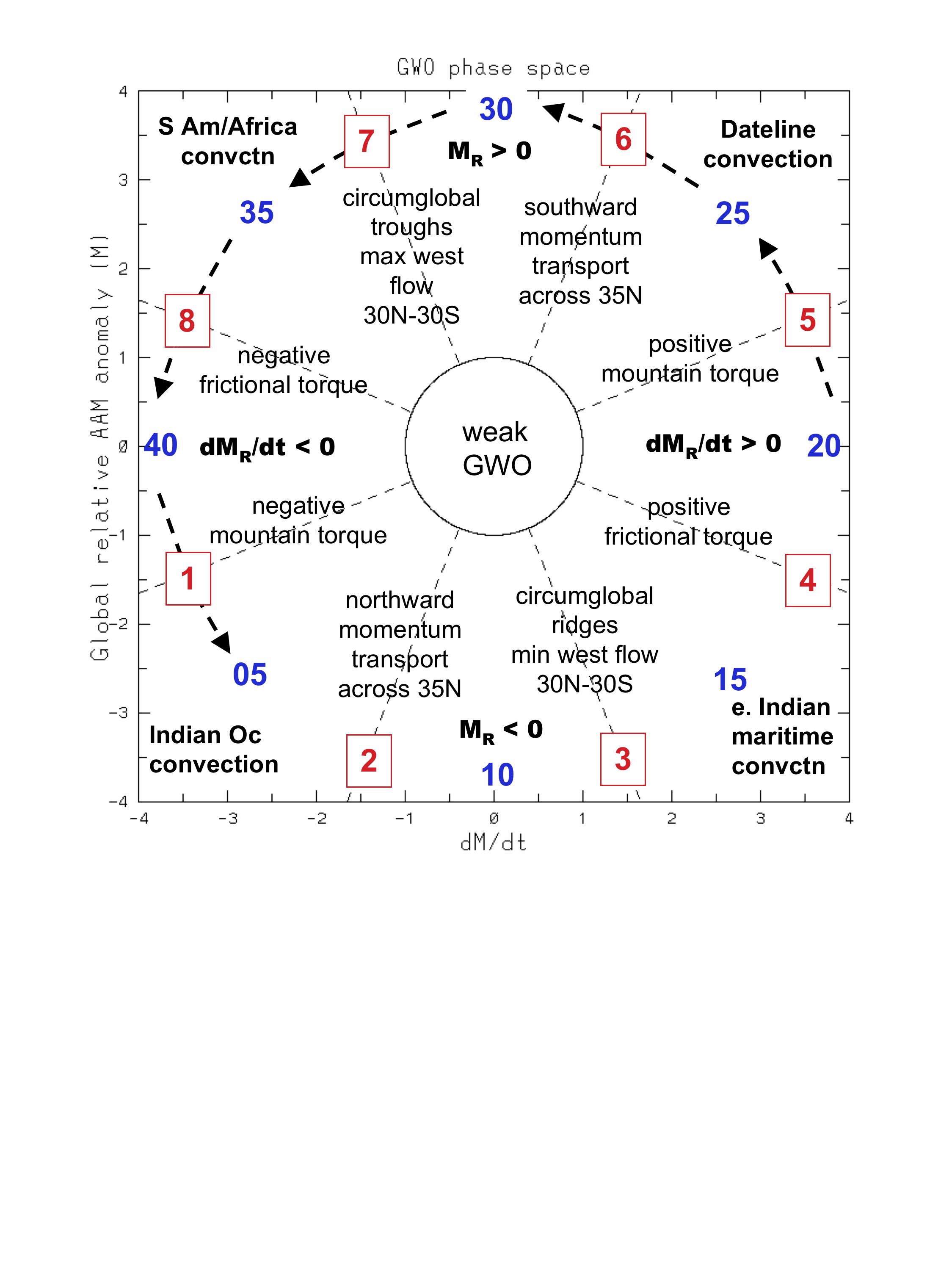
If we take another look at a yearly GLAAM anomaly, the size of the peak of the-ve GLAAM anomaly achieved is evident - which saw the La Nina strengthened trade winds ramp upwards.
The atmosphere is now fast recovering from that low angular momentum regime and NWP attempting evolution of another Scandinavian ridge such as was seen in the first part of February 2017. That tropical momentum led +AAM anomaly spike, was discussed in a recent post, is clear to see again in the above 365 day chart for early February 2017
Back to ushering in Feb 2018:
High amplitude tropical convection progression with rapidly rising AAM tendency has all but scrubbed out that -3SD GLAAM deficit ^^ - and still heading upwards. The atmospheric state is becoming increasingly conducive to +ve poleward momentum flux helping to amplify the tropospheric pattern more meaningfully. This leading towards a much better shaped H500 anomaly to externally destabilise the vortex. This, at the same time as internal +ve mountain torque forcing occurs - as a direct consequence of the poleward +AAM anomalies c/o tropical forcing propagating to the extra tropics and perturbing the troposphere/stratosphere boundary.
To put some timelines to all this with the aim of helping explanations :
If we take a look at the Global Wind Oscillation below, which should be seen as a measure of how the amplified wind-flows are progressing from tropics to extra tropics- then the initial signal fired from the tropics to start the process now unfolding in NWP was around 22nd January as can be seen by the plot (high amplitude GWO Phase 3 into Phase 4).
This signal is representative of a surface +ve frictional torque which indicates the axis points where westerly winds in the tropics added by the forward movement of tropical convection start the initial process of scrubbing out the easterly trade winds responsible for the greater polar jet flow at mid-latitudes that inhibits amplification.
The lag time for this +ve frictional torque and associated poleward heading +AAM wave flux anomalies to arrive in the extra tropics is ~10 days. Based on the starting pistol fired around the 22nd January, the GWO progression confirms this ETA of momentum in the extra tropics by the imminent expected orbit to the boundary of Phase 4/5 and engagement of a considerable size +ve mountain torque.
See the added GWO template that confirms where these torque processes have taken place within the relevant phase progressions
This mountain torque event has some highly interesting possible implications - not just for the amplification programme clearly underway in NWP into the medium term and increasing programme of cold air advection, but also in terms of the sharper NH hemispheric pattern which corresponds to assist external stratospheric meltdown.
Such as stratosphere forecasts are playing peek-a-boo with.
At this stage, what is interesting about the current evolution is that, *she adds with due caution* it looks slower and more sustained than Feb 2017.
There are tentative suggestions of a slow burner, as the models keep adjusting the pattern further on into the medium term to one that is more meridional due to +AAM flux.
It *could be* that the +ve MT delivers something of an icing on the cake from mid month. Something to keep watching out for in the longer term.
Lag time for +MT >stratosphere/troposphere fall-out around 12- 14 days.
This zonal wind cross section illustrates how the westerly wind additions c/o tropical forcing is impacting the rossby wave pattern upstream, with the emerging propagation of +ve shaded anomalies replacing the sustained bursts of -ve anomaly easterly trade winds evident across the Pacific since the turn of the New Year.
This is another way of illustrating the switch from sharply -ve AAM anomalies to a contrasting swathe of +AAM anomalies impacting the extra tropics and as a consequence re-configuring the pattern from upstream with less strength into the northern branch of the jet stream - with more split jet flow and consequently greater trough disruption downstream - hence better mid to higher latitude amplification of ridging.
The signs are emerging that the new travel of direction is gaining traction - with suggestions the models are contemplating a volte face towards a cold and blocked pattern with CAA ambush from both the NW and NE. As soon as this weekend.
All rather confirming suspicions of recent days, and echoed in the semantics of the highlighted post above- that the flatter low angular momentum legacy might well be over-cooked.
In that sense on-going NWP suites are simply snapshots in time to the evolution of the pattern playing out.
Adopting this philosophy, it becomes more possible to watch what happens without unnecessary instinctive reactions to face value variations and swings within intra day operational modelling (and ensemble suites)
I'm not sure that either of these have been especially instructive to any great distance of late. If the latest trends are anything to go by this is already obvious.
Its not through it being my own model of choice based around preference, but because its the model that has been best fitting the pattern to the signals on this occasion that the UKMO has been leading the way and paving the evolution of the pattern into the weekend and beyond. NWP is starting to better matches the suggested GWO evolution of recent days and makes more sense (to me at least!)
It does seem that an all-round catch-up is in progress and that might seem a (very pleasant) surprise to anyone who has taken NWP at face value in recent days
Super informative post. Thanks Tamara
-
6
-
1
-
-
1 minute ago, Seasonality said:
Its Piers Corbyn isn't it! Come on, you can tell me.
Maybe Michael Fish...
-
1 minute ago, WalsallWeather123 said:
You won't know them. They are also amateur but very experienced. Anyway I might be wrong who knows. But caution is best until T72
Ahhh the reliable amateurs. Those are my favourite kind
-
4
-
-
3 minutes ago, WalsallWeather123 said:
The charts are showing a cold spell but I'm told by a couple of reliable weather guys that they expect them to backtrack in 24 hours. I'm an amateur myself but this is what I am being told
My dog tells me it’s going to verify and he knows his stuff
-
2
-
-
16 hours ago, Froze were the Days said:
2013/14 was far far worse than this one for continuous cloud, rain, wind and mildness...I've never been so happy for a winter to end it really was that bad!...it felt like it went on for months unabated.
Yes. This exactly. We had a puppy that winter and I was out with her every 20 minutes while house training and it was bloody dire
-
Quote didn’t attach. Doh
-
16 minutes ago, Snowmadsam said:
Just a reminder folks to contain yourselfs...remember ONE run. Gotta have that trend.
Just trying to keep the feet on the ground
We’ve had a solid 24hr + of upgrades though. It’s pretty fair to say this is trending
-
3
-
-
My first post here. I’ve lurked and followed here for 3 years or so and find these threads absolutely fascinating. So a quick thank you to everyone that contributes to the many discussions I follow and learn from.
The battleground Britain charts are incredible to watch develop. Here’s holding to further upgrades today.
-
7
-
-
It’s rather windy here in Swindon. Nothing too dramatic but enough to keep my son and I in the house. People don’t realise how unbearable winds can be for people with autism and sensory issues.
My girls are on the trampoline hoping it will take off. I don’t have the heart to tell them.
-
1
-


Model output discussion - mid January
in Forecast Model Discussion
Posted
?? Read this with Offspring - Kids Aren’t Alright playing and I swear to god he’d dancing perfectly in time with the music. I’m dead ??
The 18Z is absolutely blinding. I hope this keeps going. Cannot wait to see Walsal eat humble pie in the AM!! ?
I make that now a solid 7 consecutive runs with upgrades. I’ve not seen that happen for some time. Next weeks looks set to be pretty bloody spectacular. Just in time for half term too!!