
- Popular Post


mushymanrob
-
Posts
8,995 -
Joined
-
Last visited
-
Days Won
18
Content Type
Forums
Blogs
Gallery
Events
Learn About Weather and Meteorology
Community guides
Posts posted by mushymanrob
-
-
Hovmoller is also looking to around the tenth for pressure rise (along with the EPS)

-
 5
5
-
 1
1
-
-
27 minutes ago, Addicks Fan 1981 said:
Just looked at the NOAA 8-14 day chart anomoly and the mean trough does seem present still, but the mean trough to me doesn't look as vigorous as it did before or has done on previous runs, very similar to the ECM 00Z ensemble this morning actually.
 Climate Prediction Center - 8-14 Day 500mb Outlook
WWW.CPC.NCEP.NOAA.GOV
Climate Prediction Center - 8-14 Day 500mb Outlook
WWW.CPC.NCEP.NOAA.GOVIndeed, there is apparently some weakening, but maybe we are looking too hard. We need more runs to see if this develops further.
-
3
-
-
1 hour ago, summer blizzard said:
Whether summer is over largely depends on what somebody considers to be worthy of summer. We can I think now write off the first third of August and the thermal maximum for the UK. That is not to say that we could not have a settled second half of August however it should be noted that even in warm August's, most don't have the legs and by the final third, you start to lose any significantly settled weather.
Well id suggest that Summer lovers like heat, just as Winter lovers like cold, "average" in Winter wont appease cold lovers any more then average in Summer would satisfy heat lovers..
-
3
-
1
-
-
28 minutes ago, Addicks Fan 1981 said:
as things stand, its on its own and these charts have been suggesting an improvement on several occassions this month, all of which has failed.
-
1 hour ago, mushymanrob said:
I know people say "you cant write off Summer yet" .... and usually that has some credibility. But this year we are stuck in a pattern thats 180 degrees from one needed to produce heat. We can "see" pretty well now into mid August, and we retain the cool unsettled theme. Every "improvement" the longer term Anomalies has hinted at has been put back time and time again. A change in pattern to one that could possibly support a route to heat is at least ten days away and probably longer. It might warm up/settle down by the Bank Holiday, and September might turn out to be cracking.. but September isnt Summer on anything other than a man made definition on a calendar that tidies it up.
So im in agreement with you here.... IF we get any settled warmth itll be too late in the season to rescue Summer, and most of us have forgotten Junes nice spell, eclipsed by July rain.... which is ironic after last July was one of the driest on records................ i say that then THIS crops up! LOL
Ill believe it when it has support, so far it doesnt, trend spotter our outlier?-
7
-
2
-
-
1 hour ago, Mike Poole said:
No hope of anything remotely summary in the foreseeable, according to the ECM clusters this morning, T192-T240:
6 shades of dross!
T264+ does suggest some respite, probably transient though.
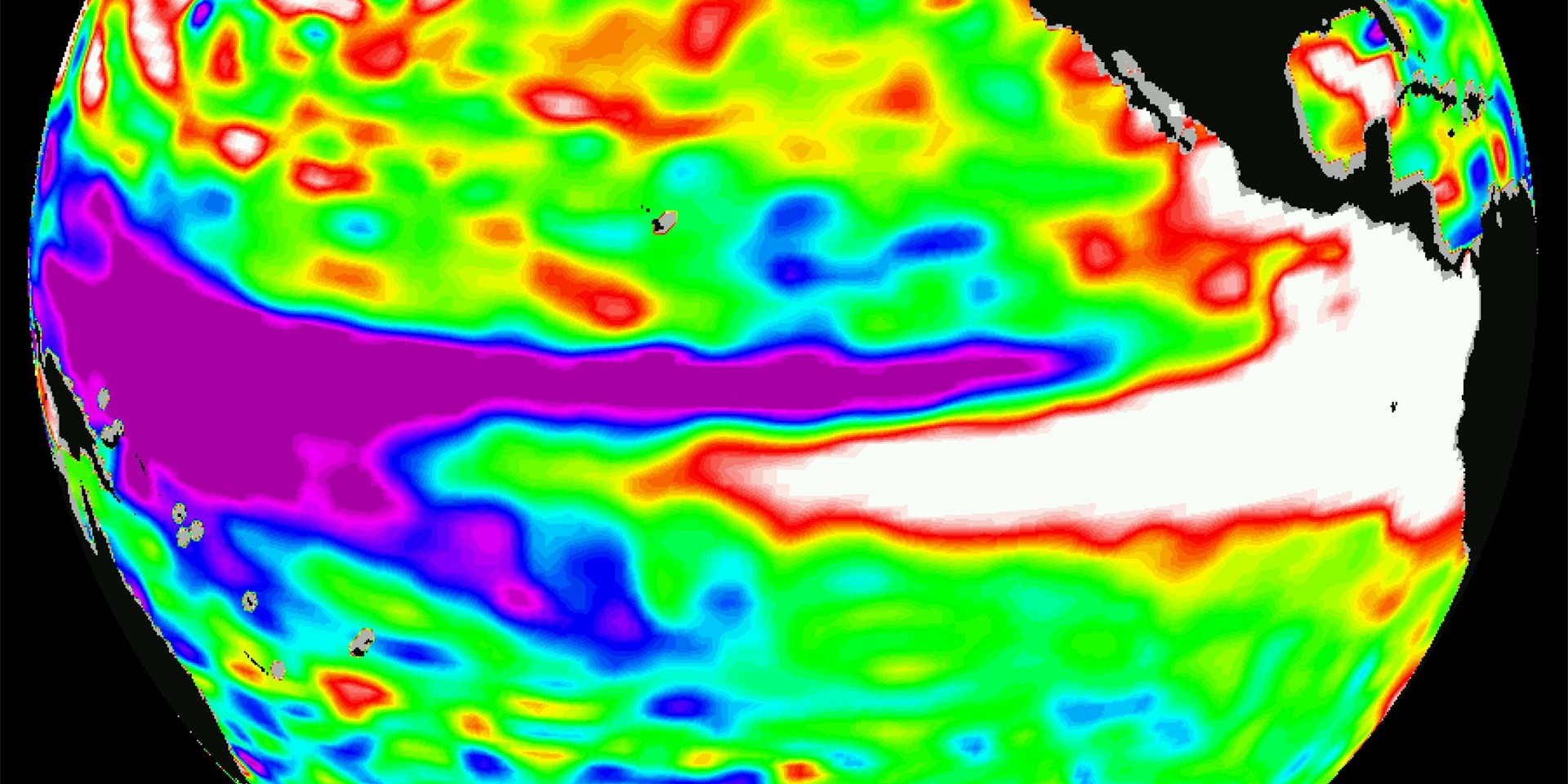
I think we have reached a point where summer cannot recover. Yes, the relaxation of the 5 wave pattern in August will probably lead to some transient fine spells that have been absent in July. But I think the idea that a longer hot spell can be manufactured from somewhere is probably for the birds. I commented in late spring that I was looking for the kind of positive reinforcement pattern that is the hallmark of a good summer, and we had that in June, but any such pattern is totally ruined now. As an example, compare the SST anomalies for today and a month ago, today on left:
The anomalously warm area around and southwest of the UK is gone, and as @Tamara noted yesterday, there is now a big warm anomaly further west, where we don’t want it.
Too late in the season to set up a decent summer pattern from scratch again now, I would say. Most likely settled weather will return in September, as it often does, but that’s for another day.
I know people say "you cant write off Summer yet" .... and usually that has some credibility. But this year we are stuck in a pattern thats 180 degrees from one needed to produce heat. We can "see" pretty well now into mid August, and we retain the cool unsettled theme. Every "improvement" the longer term Anomalies has hinted at has been put back time and time again. A change in pattern to one that could possibly support a route to heat is at least ten days away and probably longer. It might warm up/settle down by the Bank Holiday, and September might turn out to be cracking.. but September isnt Summer on anything other than a man made definition on a calendar that tidies it up.
So im in agreement with you here.... IF we get any settled warmth itll be too late in the season to rescue Summer, and most of us have forgotten Junes nice spell, eclipsed by July rain.... which is ironic after last July was one of the driest on records.-
5
-
-
yep, quite a few reports from this morning including dublin...
-
1
-
-
ill just leave this here....
-
4
-
2
-
-
9 minutes ago, MP-R said:
Pretty sure 17/18 was a La Niña winter.

it was.
-
 1
1
-
-
10 hours ago, Sprites said:
Derbyshire has recent sightings
not here, lol...
cloud rolled in so i didnt bother... doubt we would see much now anyway.. horizon huggers..-
1
-
1
-
-
3 hours ago, Snowy L said:
Met Office say very little about ENSO effects on UK weather but the one thing they feel confident enough to say is the increased likelihood of cold winters during El Nino years.
What are El Niño and La Niña?
WWW.METOFFICE.GOV.UKEl Niño and La Niña are terms which describe the biggest fluctuation in the Earth's climate system and can have consequences across the globe.The stats dont support that, El Nino Winters since 1990 (when warming started getting going) - 91/2, 94/5, 97/8, 02/3, 04/5, 06/7, 09/10, 14/5. 15/6, 18/9 all these were El Nino for the full 3 months.......... out of those ten , only 09/10 produced any cold/snow. the rest were mild and wet (ok there were some minor snow events in some years).... plus the sst anomaly in the Atlantic would suggest milder more likely.
Original post: https://community.netweather.tv/topic/99056-model-output-discussion-mid-summer-onwards/?do=findComment&comment=4896000-
1
-
-
3 minutes ago, Addicks Fan 1981 said:
What is your perception of the models tonight @mushymanrob just out of interest? To me pretty much the same as this morning although in time I do reckon that the trough won't be as prevalent as the month of August progresses.
Not seen em... wont until tomorrow because im not expecting any change
-
1
-
-
Just now, CreweCold said:
But if it's cyclical then we have no idea when it may revert...we don't even know what has caused the discrepancy so we don't even know what may cause it to revert.
... but we are warming.
Anyway, lets see how it plays out. No point in going too deeply into what might happen in winter. I dont think it looks good for cold/snow for reasons stated. Only time will tell if my thoughts are right or wrong... so be it..
-
2
-
-
4 hours ago, razorgrain said:
I may be mistaken, but didn't our last run of notably cold/snowy winter around 2009/2010 also coincide with a solar minimum and that volcanic eruption in Iceland spewing ash across Europe? Certainly different synoptics this time around.
I can find no correlation between solar maximums/minimums and cold/mild winters or warm/wet summers
-
3 hours ago, CreweCold said:
But if you go even further back, El Niño analogues show a propensity for N Atlantic ridging. So there may be cycles that affect the effects of El Niño…and who knows when that will flip again (it may already have!)
If you wander into the ENSO thread you’ll see the analogues for strong Nino are very different between the first half of the 20th century and later on into the 2000s
...... but we live now, not in the past.. hence i used the "since 1990" because imho the past 30 years are more relevant then more historical times.
-
1
-
-
Clear night too... any chance?
-
3 hours ago, Snowy L said:
Met Office say very little about ENSO effects on UK weather but the one thing they feel confident enough to say is the increased likelihood of cold winters during El Nino years.
What are El Niño and La Niña?
WWW.METOFFICE.GOV.UKEl Niño and La Niña are terms which describe the biggest fluctuation in the Earth's climate system and can have consequences across the globe.The stats dont support that, El Nino Winters since 1990 (when warming started getting going) - 91/2, 94/5, 97/8, 02/3, 04/5, 06/7, 09/10, 14/5. 15/6, 18/9 all these were El Nino for the full 3 months.......... out of those ten , only 09/10 produced any cold/snow. the rest were mild and wet (ok there were some minor snow events in some years).... plus the sst anomaly in the Atlantic would suggest milder more likely.
-
3
-
-
35 minutes ago, MATTWOLVES 3 said:
But what really piques my interest is that EQBO....its possible we could be in a much better place for some favourable winter sypnotics this time around..very early doors and I don't wanna send the thread off topic with winter talk...but watch this space.
............ only we are heading towards an El Nino phase for the Winter, and El NIno Winters are usually warm, wet and windy.. with the higher than normal Atlantic SSTs, this Winter IMHO isnt looking good for Wintry weather, but could be quite stormy.
-
5
-
-
EPS is becoming consistent suggesting something less unsettled ...
Hovmoller agrees..
some improvement after week 1.. possibly..-
4
-
-
-
1 hour ago, Methuselah said:
I think I might be losing the will to live. If Climate Change denial isn't daft enough (I'm a 'warmist!), I'm now also a 'globist'!
no.. youre a "globtard" .. the same as me, because we havnt done our "ReesURch", which involves forgetting everything youve been taught at school (thats indoctrination), ignoring the laws of physics, and being educated by watching half baked youtube vids.
Flat Earthers are the dumbest people on the planet....-
1
-
-
41 minutes ago, danm said:
I'm not sure you actually read @Backtrack's post that you quoted. He did specifically say nothing spectacular is modelled, no heatwave is showing, but things are likely to turn drier and warmer next week.
Looking just at the GFS SLP mean for the moment, it IS showing a rise in pressure in early August for London, relative to this week and weekend. That doesn't mean a heatwave, but could mean more days that are dry and sunny compared to what we've been having recently.
Not going around in circles he said she said... my last post made it perfectly clear...
-
1
-
-
44 minutes ago, alexisj9 said:
NOAA use the outputs of a number of models to make the anomaly charts. So they will agree with the models, for now it does look like they feel the ECM has things covered at this time frame. It isn't guess work, and there always a confidence rating with the chart, which has been top end for a few days now.
to be precise "The official 6-10 day 500-hPa height blend consists of 35% of Today's 0z GFS Ensemble Mean centered on Day 8, 40% of Today's 0z European Ensemble Mean centered on Day 8, and 25% of Today's 0z Canadian Ensemble Mean centered on Day 8" .... which is why they are accurate.
44 minutes ago, Backtrack said:The average 850hpa chart isn’t what I was referring to in my post though. We know there’s no major, prolonged heat on the horizon but my point was there’s plenty of HP incursions happening on each run, with 2-6th August always showing up as a timeframe for ridging.
It’s all well and good using a chart to show the average, but those charts won’t paint the full picture as to what we can expect, rather just a generalisation and it’s why I don’t use them as much to show the day by day. The anomaly charts illustrate greatly the most likely overall scenario, but I can’t recall many, if any potent HP incursions in July for my location. August is currently offering that on pretty much every run with consistency surrounding particular dates.
Semi-reliable timeframe, warmer air being swept our way aloft. This chart leads to a pretty much above average day for much of England and Wales. Can’t say I’ve seen any days like this in July. A marked improvement. Followed clearly by a lower pressure incursion but the GFS is keen to build another transient ridge afterwards.
Building blocks and improvements.
Well i dont disagree that there is likely to be transient ridges, like i said "average unsettled", but i see no sign of "building blocks" beyond a return to average (which isnt bad for early August) ... so we are on the same page?
-
4
-
1
-
-
some were seen this morning through gaps in the cloud... saw nothing on the euro cams last night though.
-
1
-


Model Output Discussion - Mid Summer Onwards
in Forecast Model Discussion
Posted
and with steadily growing evidence... the EPS is adamant that higher pressure is on the way
