


snowflakey
-
Posts
158 -
Joined
-
Last visited
Content Type
Forums
Blogs
Gallery
Events
Learn About Weather and Meteorology
Community guides
Posts posted by snowflakey
-
-
Hi all, Am I missing something, but to me the models look fairly uninspiring at the moment with HP to the south preventing any cold from traveling awer way.

-
yes that theme continues towards early October as well, perhaps some sign of a more anticyclonic spell developing for October but that is far from clear.
End of the summery weather for the UK, well those parts that have enjoyed that type recently.
Yes looks like a quick transition to a cool Autumnal set up this year. I do think that we will not see the the 20c temp being broken now until next year.
-
GFS ens showing a cooling trend.
-
I might sound stupid but i have seen you mention MAH a few times, what does this mean? thanks.
Hi Mark, its abbreviation for a Mid Atlantic High and quite often it can ridge northwards (retrogress) and merge with the Greenland high to bring us a cold northely in Winter. Some more abbreviation that are sometimes use are GH Greenland High, AH Azores High, One abbreviation witch had me guessing fora long time was the GIN sea, witch turned out to be the Greenland, Iceland, Norway sea.
-
Apologies if this point has been aired before, but I was wondering if this potentially northerly set up, with a MAH/Greenland was common this early on in the season, I seem to remember a slow change from summer to winter through September and October with HP influencing the south for a lot longer than the models are indicating at the moment.
-
Currently models are modelling the trough in what I would describe the most interesting location weatherwise thus being cool/chilly, wet and windy with winds from NW /to N to ENE. What I'm liking the look of is that LPs that feed towards us from southern Greenland generally prevent the HP to our SW from retrogressing to Greenalnd and we get zoneality. Models continue forcefully with the HP 'will' get there and LPs on a NW/SE movement. Would be very interesting late autumn early winter pattern, but for now a below average chilly pattern. Still though the trough set up is far from sorted and we are likely to see differences. movement
BFTP
Yes a very interesting outlook IMO, I wouldn't mind betting that a Greenland/MAH marriage will happen sooner than the models are predicting, the MAH looks as though it wants to retrogress.
-
No fresh snow jet on the mountain facing the web cam on Svalbard.
-
Currently -2.5c with dp -8.1 on the IOW
-
-1c and -8.3dp at Newport IOW
Fingers crossed for Saturday night, allays a bit sceptical about a predicted snowfest for the Island but have been proven wrong the last couple of years.
-
I know on the liveing south coast we can be a few deg warmer than inland, but with a progresivly colder outlook over the next few days I find 7c for this thurs a bit on the high side. I was thinking more of 2c or 3c.
-
I always wonder how useful a Thames streamer can be to those on the periphery of the Thames valley? From an imby perspective can it deliver for those in north hampshire?
FI, but this channel low would be nice
Very borderline snow event I would have thought, very critcal on the path of the Low preasure. a lot of milder maritime air being sucked into the mix. Probably north of the M4 coridor should get a hammering from that set up.
-
Hi all been luking around the fprums for alittle while now, thought Id reveal myself and join in with the up and coming snow/cold fest (maybe). Lets see what tomorrow brings , but at the moment I think -17 850 should do it for lying snow, even me on the IOW.
-
Although there is a certain amount of scatter from the 12z gfs ens, it is quite interesting to note that most of the members agree on a cool then warm 850 temp, giving the ens graph a switchback look to them, indicating zonal conditions for the foreseeable.
-
Yes looks like a European high developing, lets hope the orientation is favourable for a cool/cold feed.
-
http://i1195.photobucket.com/albums/aa382/bogwish/lyb_big.jpg
A photo of the Harbour at Longyearbyen Svalbard, copied off the web cam a couple of days ago, as you can see there is no snow on the high ground opposite yet.
My apologise if this hasn't worked, I'm a little new to photobukett and uploading etc.
-
ECM promise of a more settled FI scenario has seemed to have vanished this morning, but as Gibby mentioned HP is never to far away. I suspect the Jet will win the day on this occasion, but interesting times ahead I feel.
-
Maybe Great Dun fell will have something a little wintry, if a northerly settles in next week.
-
Thought id bump this thread up with a vid of JB on Fox News. No comment on the contents, that's for another topic.
http://wattsupwiththat.com/2011/06/03/laminate floori-on-the-non-existent-climate-tornado-linkage/#more-40986
Opps the link doset go all the way, click on the "continue reading" link below the Rosie ODonnell vidio.
-
I see from Twitter Joe B has just started a new contract with WeatherBell. I don't know if this means we will be treated to his free video, or if it will be a subscription.
-
Looks like another potent northerly developing as we go into the new year. My only concern is, that the Siberian high this year seems to be orientated wrongly for us to tap into some very cold air from northern Russia. The last northerly outbreak gave me some snow and low temps, but also some maritime influence witch gave a very steep temp gradient near the coasts. Quite often a northerly is followed by a scandy/Siberian high resulting in a bone numbing eastley that effects the South and SE, this seems unlikly IMO. Would someone more knowledgeable than myself please tell me I'm wrong.
-
Many thanks Paul, very useful.
-
The PV has always intreged me. I understand how LP systems are formed, but the PV seems to be a permanent feature like the Azores high. unlike the the Azores high, however, witch forms because of decending air from the equator, the PV iis a mysterey to me. How is it formed? When it moves south and effecte are weather, it seem to me that HP over Scandy quite often developes, is this because of WAA on it eastern side? Does another vortex form when one moves south towards us? if so are Powlar low just a series of PV forming in the Artic air? It seems a strange beast to me.
A lot of supid questions and some very bad spelling, Im sorry for that. A link pointing me in the right direction will probably be enough to satify my cureocity, many thanks Pete (IOW)
-
It seems a little late this year. How often does the Equinox drift out to the 23ed. If you wre at the north pole the sun would just be setting, not to reappear untill the Spring Eqiniox
-
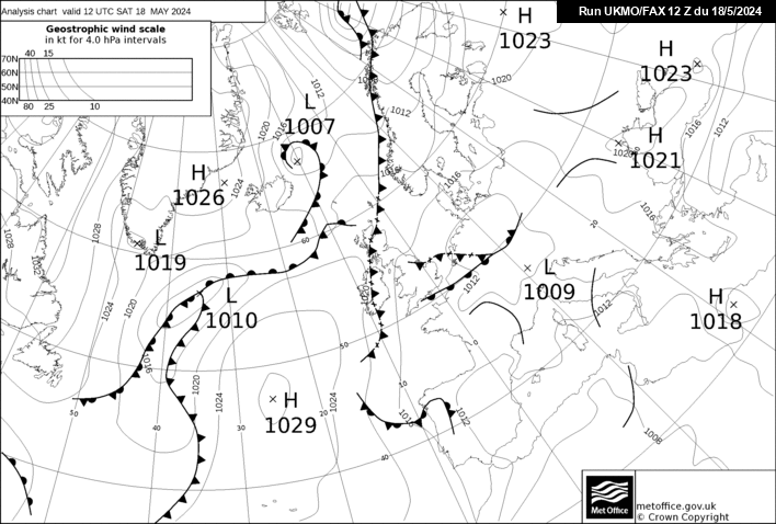
Latest fax shows the upper warm front across England at midnight.
This has obviously helped to modify ground temps along with the wind off the warmer N.sea.
Many stations up and down the East coast reporting temps 2-3C and Bulmer was 4C recently.
Looking at the Fax above it looks to me as though were are not out the wood yet as regards this cold spell.I haven't seen the latest model outputs, but that block could quite easily reinserts itself


Model Mayhem - Moan, Ramp, Go Nuts
in Forecast Model Discussion
Posted
Here we go again, block holding, Atlantic at bay and old blighty in the middle. I think Ill have to up the medication to deal with the mood swings.