


ribster
-
Posts
814 -
Joined
-
Last visited
-
Days Won
2
Content Type
Forums
Blogs
Gallery
Events
Learn About Weather and Meteorology
Community guides
Posts posted by ribster
-
-
18 minutes ago, winterof79 said:
What cold spell. It hasn't happened.
Depends where you are, been 9 days and counting here. Models seem to suggest another 4/5 days of the same, very nice ta!
-
1 hour ago, ribster said:
Funny you know exactly how the usual suspects are going to post in the model thread, peeing on others bonfires. More gratuitous use of the ignore function needed I think...
Same posters have nothing to say about ECM
-
Funny you know exactly how the usual suspects are going to post in the model thread, peeing on others bonfires. More gratuitous use of the ignore function needed I think...
-
 1
1
-
-
8 minutes ago, Sheldon Cooper said:
Gonna Be Colder Earlier Then.
And warmer later...
Love your enthusiasm, but think you may need to temper your posting a little.
-
4
-
-
Totally confused as to why so many come out of the woodwork every year only to take delight in peeing on others bonfires. Seems a very sad past time to me, ought to take up something more constructive...
-
1 hour ago, prolongedSnowLover said:
He said it’s ‘turning milder’ which the ensembles are showing support for.
which planet do some folk live on ? Planet of denial ?
He seemed to be claiming victory for something that has not occurred yet, still cold in the immediate and near future...
No need for turd polishing, stick to the brass
-
1
-
-
52 minutes ago, dragan said:
well il be darned, i’m glad i stuck to my own thoughts on it turning milder instead of many peoples ideas and trying to put twists on the charts to provide cold. You can’t polish a turd (joby)
Certainly an upward trend in temps for sure
Has it turned milder? Still freezing outside here...
-
1
-
-
Bomb the Bass - Winter in July.
-
Is that tumbleweed...
-
2
-
-
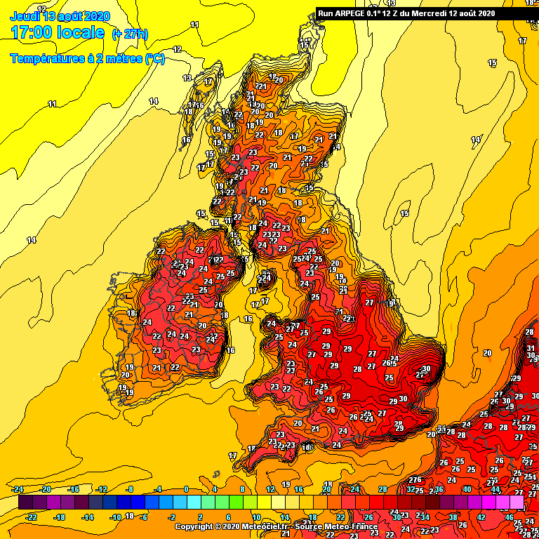
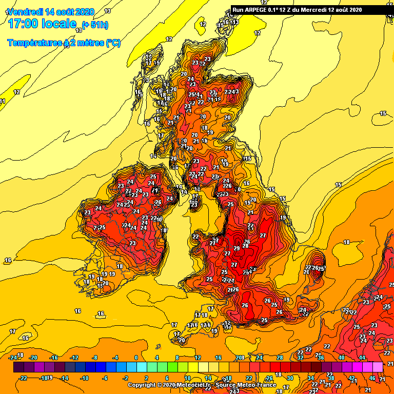
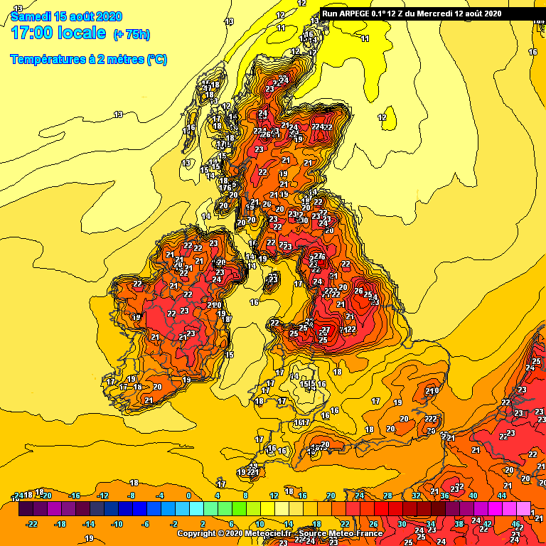
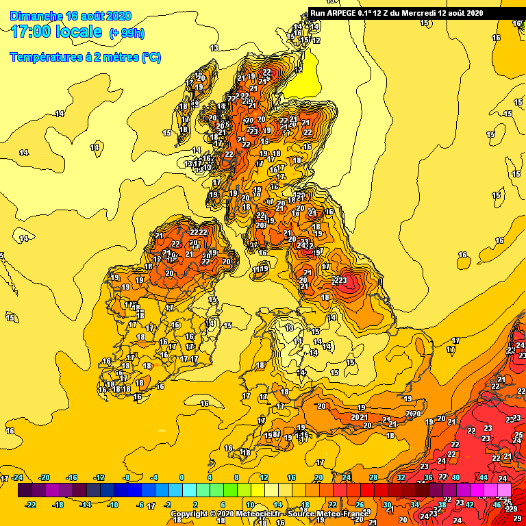
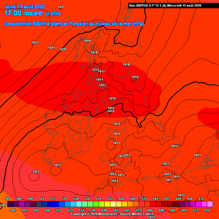
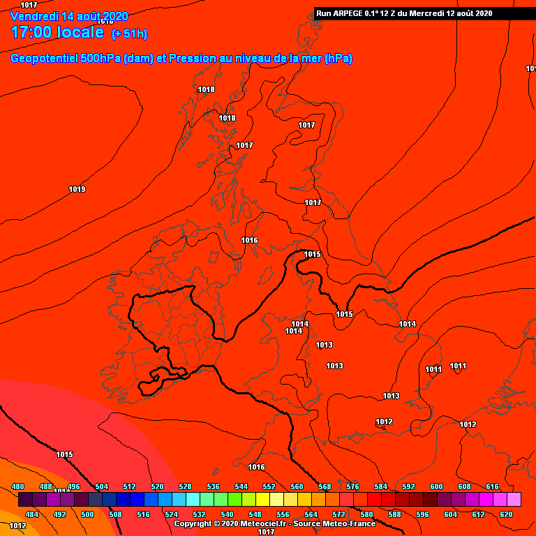
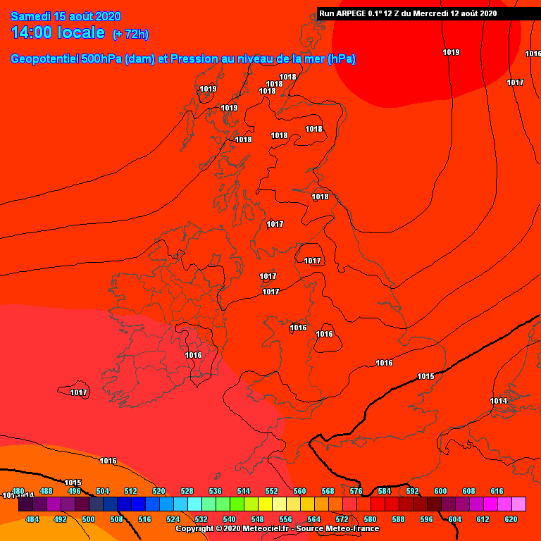
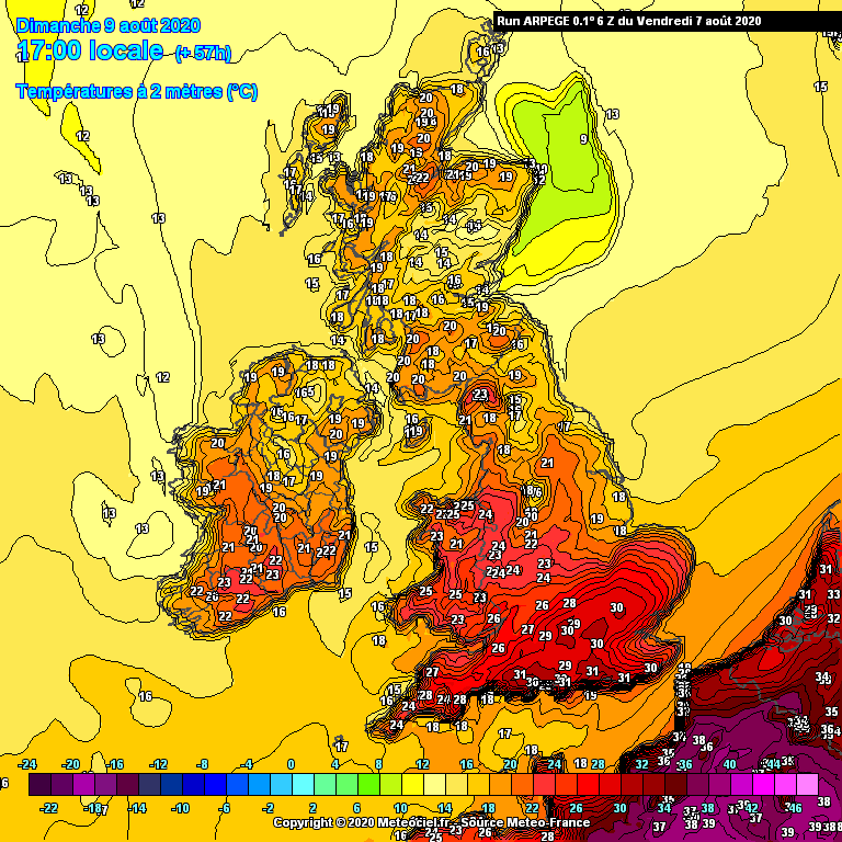
43 minutes ago, stodge said:
Evening all
Another day (the sixth in succession) above 30c in downtown East Ham - we reached 33c early afternoon but a more pronounced E'ly wind sprung up and it's starting to feel fractionally more comfortable.
Thought I'd see where Arpege is taking us and it's very interesting:

A last day of heat (30c?) tomorrow before a much cooler regime takes over for the south and east and the heat switches to the west and north on Friday and the north on Saturday.
The 500hpa synoptics are revealing:
This isn't your normal end to a short-lived hot spell with a front coming in from the Atlantic and sweeping in fresher air from west to east.
In fact, this is the reverse - a complex trough to the south and east is introducing fresher air from the north east so the residual warmth gets pushed back west and north west while the cooler air takes over the east and south. Very unusual synoptics for the end of a prolonged hot spell.
Next week is all about what the Atlantic LP will do - fans of heat will be looking for it to stall out west - 12Z GFS OP didn't suggest that, perhaps the 12Z ECM will.
Yes a very subtle difference in the feel of the air in this locale this evening. A change is afoot...
-
1 hour ago, Mark wheeler said:
I haven’t given the Mighty Navgem an outing for a while so here it is . It’s much slower to my eye anyway in clearing the heat .
incidentally has anyone noticed that recently the navgem’s uppers has fallen largely in line with the other models? Perhaps an upgrade? ( Ahem )
I see a post or Two claiming Summer is over . I suppose we can write off Winter too whilst we are at it . What Nonsense .
Can't be that wide of the mark, 21 days to go?
-
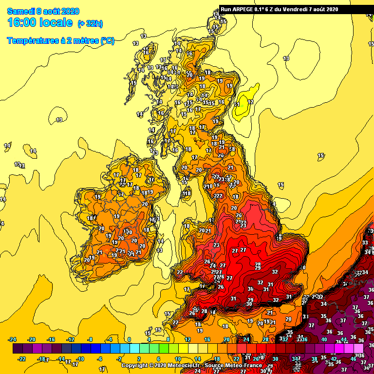
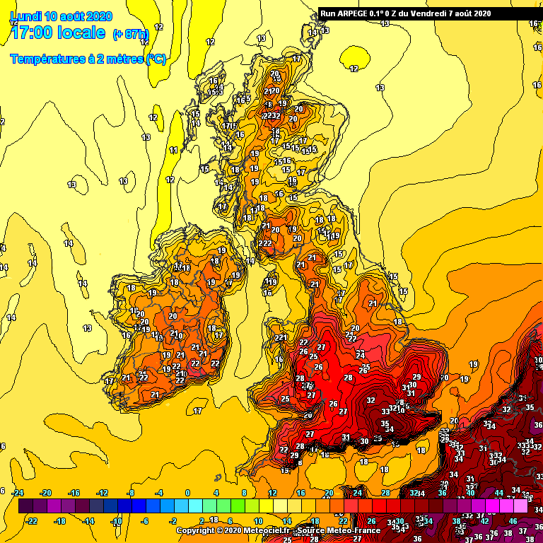
2 minutes ago, stodge said:
Afternoon all
33c here in lowland East London and looking at Arpege, has it backed off some of the really high values forecast a day or so back?
First two are from the 06Z run, last one is from the 00Z.
The curiousity is the heat being "confiend" to the southern coastal counties suggesting an onshore flow for eastern areas and that keeping London fractionally cooler.
The WRF 06Z also suggests a change in the heat profile from the more traditional broad push north of the classic plume to a more sharply defined event for the far SE.
Yes, one day wonder here, temp for today slightly revised down and more so for next four days, before dropping away further.
-
2 hours ago, clark3r said:
If bookies were taking bets on what week will be the best of summer I would bet on 2nd week of august right now
Not exactly a lofty accolade though is it...
-
4
-
-
2 hours ago, Mapantz said:
I'm not new, but seeing a single chart posted with a caption of "hmm" underneath it wasn't particularly helpful either.
Not new? Stone the crows, point taken though
-
19 minutes ago, Djdazzle said:
Deep FI. But the ECM is total rubbish, it has to be said.
Was attempting to show an opposing view to the one way street of traffic, easy for someone new to be mislead...
-
3
-
-
-
Looks a potentially brief affair to me, looks like flattening out.
-
2
-
-
1 minute ago, Zak M said:
Now that's a scorcher
I'll get the bbq ready!
-
2
-
-
2 hours ago, General Cluster said:
As per usual, the runs are nowhere as bad as some of the predictions allegedly based on them... But the most bizarre of the lot, is expecting charts, for Day 14, to verify; by that time, NWP forecasts are almost always nonsense. Think of all those much-hyped wintertime Snowmageddon scenarios that fail to materialise?
We live in neither Siberia nor Abu Dhabi!
Indeed, the distinctly average theme continues, but as you say, there's nae wrong with that. Despite a lot of expostulating to convince one way or the other, that's the way of things currently...
-
2
-
-
3 minutes ago, Zak M said:
Now THAT is what you call a perturbation...
Crikey
One perturbation, 12 days away, what could possibly go wrong?
I'm still enjoying 'average' anyway...
-
4
-
-
9 hours ago, General Cluster said:
Indeed, Karl, the GFS 00Z is not as bad as all that; some sort of ridging in evidence, at least. And, what's so dreadful about 'average' anyway?
And, as the ensembles show, there's a lot going on; though, in these parts at least, perhaps not enough in the rainfall department?
NH Profiles:
Nothing at all, loving average, long may it continue!
-
3
-
-
58 minutes ago, General Cluster said:
Equally there has been an awful amount of hyperbole over a 3 day hot spell in June, yes June!
-
1
-
-
1 hour ago, Zak M said:
GEM looks very tasty for Wednesday
The mighty GEM
-
1
-
-
16 minutes ago, Mark wheeler said:
Well you know what I’m glad Gfs shows this on the pub run . Why? Because One it’s Gfs and two It’s normally wrong .
Looks very similar to UKMO at 144 to me, we've all seen ECM implode at just 72 hours.
-
1
-


Winter 2020/21 chat, ramps, moans and banter
in Spring Weather Discussion
Posted
Sounds like this forum isn't for you then!