


Yeti
-
Posts
1,277 -
Joined
-
Last visited
Content Type
Forums
Blogs
Gallery
Events
Learn About Weather and Meteorology
Community guides
Posts posted by Yeti
-
-
The whining is irritating me that much im going to refrain from posting until the 12Zs!
Some people seriously need to get a grip and compare these charts to previous Decembers!!
Lastly let me ask the whiners a question. If this was 1947 or 1963 do you really think the models would predict endless E,lys/N,lys?

Tbh Dave I think it's the constant mentioning of 1947/63 that's driving some people mad on here; there's being realistic, optimistic and then there's just plain ramping and it's been going on too much here imo! I'm not whining - I'm really happy that we have synoptics setting up like they are doing - but despite their similarity to these epic years, their effects will be very different, particularly in terms of depth of cold and snow.
-
ecm gfs
Perhaps the 2nd bite of the cherry will be the biggest?
I've heard that before!! There are two easterlies that have certainly downgraded somewhat now (to different extents). The northerly looks exciting at the moment but it's so far out I can't imagine it's being programmed anything like correctly yet. Expect shunts either W or E, as per usual...
-
One good thing on the 6z though is that the flow falls very slack later on - it's a pity this doesn't happen after really cold uppers have become entrenched because then minima would be even lower but as we can see here (and these will be too high I imagine) there should be some impressive temps in frost hollows, inland and places where there is any snow cover:
-
Very nice 06 run, but........
People in scotland LOOK OUT!
At 138hrs there is a large yellow dog about to bite you :lol:
The 6z pulls the cold plunge further W into central Europe and so the block doesn't ridge Eastwards as much - hopefully this means the Iberian system is more likely to swing up NE to meet the low in the Eastern Med rather than merge with the GIN low N of the British Isles, giving us a better chance of the Northerly and -ve NAO setting up further E.
-
reallyy a 6c max i thought we were getting 3c maxes.... it looks like this cold spell is constantly downgrading...
Yes, temps are definitely downgrading at the moment as is to be expected really as the GFS fine tunes things. So far the last few runs have lifted max temps on Tuesday from -4 to -2 here and the 6z is no exception. I still think this could end up a huge disappointment for SOME on here i.e. those who are expected heavy, settling snow, simply because ground temps are higher than we would like. Even on the 0z minima are around 3-4c on the coasts and inland are around 1-2 with things holding below 0 further W and into Wales; these of course being the areas where snow is far less likely to fall.
Some people will undoubtedly do quite well but there is endless "amazement" on here as to why the Metoffice is refusing to ramp this up. This is simply because they can't see huge potential for widespread snow and disruption - and ice is unlikely to be too much of a problem either. Whilst the synoptics are absolutely stunning, we're still missing the deep cold pool of cold spells from the past and with it the low temperatures and acute convection. Sorry to be a bore but look at the amazing synoptics here and the (comparatively) disappointing minima:
http://www.wetterzentrale.de/pics/Rtavn1141.png
http://www.wetterzentrale.de/pics/Rtavn11417.png
Nights holding above 0 in many parts, although conditions are probably just about right for snow to fall. I still feel that cool to cold temperatures, cool uppers and a distinct lack of ppn for most of the time does not a spectacular cold spell make. The general forecast for a cool to cold period with wintry showers and some snow at times may well hold true - and whilst I'd welcome that any day, some people might not be so content...
-
That's it....rub it in!!!
We have maxes of........OMG!!!!! -0'C-1'C!!! SO THERE!
Lol you'll be the one laughing with all your snow showers while I sit here staring at Arctic sunshine wishing I lived near some water!
-
Look at those max temps, -7 here!
http://www.wetterzentrale.de/pics/Rtavn16217.png
That's literally -15 uppers in the English channel:
http://www.wetterzentrale.de/pics/Rtavn1562.png
The shortwave is shunted maybe 100/200 miles further S on this run; hence the snow risk increases for everyone.
-
Some nice convection for the East Midlands there!
http://www.wetterzentrale.de/pics/Rtavn1264.png
These synoptics are awesome, just look at that swathe of low heights moving in at 120:
http://www.wetterzentrale.de/pics/Rtavn1201.png
Feeling pretty raw too with the temps and wind:
-
Overall very good this evening , I would just like to say I can still see Snow showers in the midlands on Sunday , I can't see why nobody else is picking up on it , -5 850 , 528 dam and precipitation over the Midlands all night into Monday according to the latest UKMO charts. Does anybody else see this or is it just me ?
Chris
I think it's just you - looks far too mild to me:
http://www.wetterzentrale.de/pics/Rtavn4817.png
We'll have to wait till next week with the colder uppers and lower heights (hopefully) until any real snow potential begins. Wednesday/Thursday looking the best so far for the UK but remember the position of the shortwave is changing quite a lot so the whole setup could end up a few hundred miles further S still (like the 6z).
-
Remind me someone, when was that appalling occasion when the cold outlook collapsed across the models with very short notice? I was talking to someone a while ago about this yesterday and couldn't pin down the date! I do remember it traumatised practically everyone at the time and really put the skids under the trust in a couple of models for months afterwards....
BTW I'm not suggesting we are going to see a re-run before anyone starts twitching!
I believe that was January 2006, with the mother of all Easterlies (-15 isotherm reaching UK) out at about 144 only for it to collapse dramatically into a total non-event!
-
That's the -16 encroaching this area!
http://www.wetterzentrale.de/pics/Rtavn2401.png
A nice Northerly reload in FI there (and not a toppler!) so all in all a much better run than the 0z which was a bit messy in FI and had an area of HP sitting over Europe (the last thing we want).
-
Still some slight differences even at +60 with the 06Z likely to pull in colder E,lys for early next week compared to the other models.
Now at first glance you would say the other models are right. However for the period between +0 & +60 I find the GFS more reliable than even the Fax charts. This was the case with the precip charts during the cold spell in Feb.
Yep, GFS proved pretty awesome last year when it came to precipitation, especially wrt the track and northern extent of fronts.
-
Nice!
Many cm's of snow throughout next week... (Maybe!)
That just says "Schnee im Bergland" (snow in the mountains). Things really aren't looking that snowy at all I'm afraid from the 00z runs, except maybe on the coasts. Before next Thursday the pressure is either too high or the uppers aren't cold enough to produce either good convection or anything other than wintry showers (again near the coasts due to a weak flow). Thursday itself (144) looks a lot better:
http://www.wetterzentrale.de/pics/Rtavn1441.png
However, by Friday the flow is much weaker again, even though the uppers are cold, especially over Europe:
http://www.wetterzentrale.de/pics/Rtavn1681.png
http://www.wetterzentrale.de/pics/Rtavn1802.png
Obviously still a long way out at that stage, but recent runs haven't been much better either in that respect. Not that we have much to complain about - there should be some really cold days coming up...
-
Soon we will be getting to the inevitable point when two notable things happen...
1) Some get so wrapped up on wanting continual upgrade after upgrade shortly after the 'event' has started that they forget to actually 'enjoy the moment'.
2) We get the "it's an upgrade!" "no it's a downgrade!!" scenario when Bill from Dartmoor and Ben from Scotland argue with each over over whether or not a certain run/chart is an upgrade or a downgrade. The futility of these arguments between people often living at opposite ends of the country never fails to amuse/amaze me.
Then it will be "yes it's a bad run, but it's Christmas/Boxing Day/Christmas hols/New Year's Day so obviously there's missing data".
Extremely varied output tonight; lots of people want to ignore the ECM but despite all the good reasons telling me too there's still a part of me that is convinced it will turn out just like that (i.e. sinking high).
Then there's still the rather large issue of the shortwave which is equally erratic on the models; the 12z wanted to pull it right S and bring the cold air into Europe with the UK too near the high, whereas the 18z keeps it over Denmark and the Netherlands again. Its placement will have quite a big impact on the intensity of the cold spell and tightness of flow.
-
I think in this situation you need to know your own area , In this setup I know showers will reach my area , Posting 2 charts below . the PPN one is what i think is a rough guide to where I think showers will fall overall . The second chart is the wind , as you can see it is very breezy on the coast and this would ensure snow showers reach the Midlands.
I'm actually not convinced that heavy snow showers would reach that far inland under this setup.
http://www.wetterzentrale.de/pics/Rtavn1201.png
The flow isn't really that tight and never has been progged to be; with that in mind the easterlies of yore with heavy snow showers blowing right across the country look quite different to today's output:
http://www.wetterzentrale.de/pics/archive/ra/1991/Rrea00119910208.gif
You're right in that any snow showers would probably make their way to the East Midlands at least, but they will probably become lighter and less potent except nearer the coasts. I'm thinking back to last Feb which had a tighter flow and not many heavy showers made their way to inland Yorkshire (most snow came from troughs, fronts and other disturbances).
Think yourselves lucky though... no lake effect snow around here! And I was in East Anglia less than a week ago - bad luck!
-
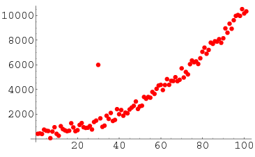
Hello my friend,
I see your point but unfortunately here it has got some credible amount of support (around 4 runs from what I can see). Bearing in mind this is in graph format and the strong links between meteorology and mathematics, in mathematics an outlier is when certain data on a given graph is anomalous from the trend
heres an example:
http://mathworld.wolfram.com/images/eps-gif/OutlierScatterplot_1000.gif
In the instance of the GFS the operational has at least some support, and so it cannot, IMO, be labeled an outlier
But i realise its a bit of a subjective topic given the definition on the forum
Kind Regards
SK
There are quite a few different definitions for identifying outliers (e.g. greater than 1.5x SD away from mean, etc.) but I agree with you; there is too much support from other members to call it an outlier.
-
It's coming, passed the point of no return, its a question now of how deep the snow is going to be as opposed to will it hit the UK or not
Some lucky place is going to get at least 30in of lying snow without doubt, wish it was down here
Are we including Canada in this?! :lol:
As we can see the sw has tracked more SW on the 18z; i.e. better for the UK with a more direct route.
http://www.wetterzentrale.de/pics/Rtavn1921.png
A very long way out, but that's some nice eye candy... snowstorm setting up in the N Sea
-
And If you think these charts are very similar you need glasses mate
ukmo http://www.wetterzentrale.de/pics/Rukm1441.gif
ecm http://www.wetterzentrale.de/pics/Recm1441.gif
gfs http://www.wetterzentrale.de/pics/Rtavn1441.png all at 144h
Well they all look pretty similar to me; remember it's T144 so you'll never get complete agreement! All show the shortwave to varying extents (GFS maybe overcooking; ECM undercooking); all show the strong block with slightly different shaping and hence these two things combined alter the flow slightly over Europe. This is all that matters atm - there have been so many past cases of totally different outcomes at 144, and yet here we have all the main models showing a cold incursion from the NE with the upper trough riding beneath the block. To me that's quite rare - rarely is there so little diversion at this range. Yes, there are differences but none so great that it's a case of "all or nothing" as seen in the past.
-
Yes, I do share your concerns wrt that low dropping south across Scandi. Both GFS and ECM show milder sector being dragged south by this low from a pool of WAA over Iceland, so uppers become less cold after the initial easterly developing this weekend. but then both models pull the low SW and allow a bitter NE'erly to develop ... eventually.
We need to hope that the upper low/cold pool eventually turns SW over the N Sea rather than sink S or SE into central Europe otherwise we may not tap into those coldest air and there is still time for the models to change in respect of a less favourable track of the shortwave moving S early next week. Alot depends on how the low develops and interacts with the southward moving jet streak down the N Sea/Scandi. Still room for error in respect of modeling the shortwave ... which may in turn delay the backing west of the real of the frigid cold towards us.
I'm praying the track changes to straight S... but that's me being selfish!
Temps a touch lower perhaps on the 18z. Just look at the WAA carving out the block at 72!
http://www.wetterzentrale.de/pics/Rtavn721.png
We haven't seen synoptics like this in years... if the current charts were to come off, we would have a cold spell to dwarf last February in both intensity and duration. And all this before Christmas!
Let's just hope it doesn't all go to pot... or I can see a bumper profit for prozac!
-
http://www.wetterzentrale.de/pics/Rtavn2401.png
That's some epic snowstorm sweeping across Europe there! :o
Personally I would much prefer an undercutting low à la UKMO; I don't understand why it can't be anything other than a good thing. It would really kick start the cold spell and drag in much deeper CAA on the northern flank rather than letting the cold filter down slowly on the back of the block that tbh looks quite slack in terms of its flow atm. Most "good old cold spells from the past" began or were greatly enhanced by this (even if the undercut did not produce much snowfall in itself) and the chances of it scuppering our hopes with a block that strong over GL are almost none. It would be too risky with a weaker/lower lat block but there is no way it could ever override the high; any low is doomed to deflect S in a good setup.
-
Well if one thing is true it's certainly that any cold is well-deserved - people here are amazed by just how unseasonably warm it has been recently! As we can see though the -5s should arrive here Friday night and ought to be nudging into the SE a day or so later:
http://www.wetterzentrale.de/pics/Rtavn662.png
http://www.wetterzentrale.de/pics/Rtavn902.png
Ice days already on the continent and I imagine it will feel pretty raw under that high in Britain, especially where any fog lingers, and with some pleasant winter sunshine around too especially away from the S.
See Thread Below about Feb'09
OH the memories!
-
Is it at all possible to view the parallel run somewhere? If not, someone fancy posting just a single chart to show me what all the excitement is?
Anyway, this run continues the trend, it seems to all be about the short waves and how they develop. We need that high to move north too!
http://www.meteociel.fr/modeles/gfse_cartes.php?ech=6&code=0&mode=0&runpara=1
NB, it's working really slowly as the whole of the NW forum has descended on meteociel...
-
I think the WAA is confirmed. That is some block in the Atlantic and no tiddly shortwave will manage to breech that in my opinion.
If I am seeing a trend in the models its, Uk High followed by Easterly and then northerly.
I think if shortwaves cause a problem it will be more likely around here:
http://www.wetterzentrale.de/pics/Rtavn961.png
The block's chances of forming at high enough latitudes could easily be scuppered if a sw nudges its way into the GIN corridor.
-
Don't mean to keep banging on the same drum - but the GFS chart viewer here updates just as fast as everywhere else (if not faster), is using the highest res version of the GFS (unlike many of the wz charts) and all the charts are in english!!
I live in Germany now so I'm allowed to!
Both runs are remarkably similar at 168, although the block looks a bit flimsier and flabbier on the 18z with a slacker flow.
Obviously though that's more-or-less irrelevant at this stage, and the general pattern is the same:
http://www.wetterzentrale.de/pics/Rtavn1801.png
T180 and the PV is shattered and starting to undercut the omega block. (:


Model Output Discussion
in Forecast Model Discussion
Posted
Now that I couldn't agree more with - my point is just that I think certain people should be more realistic about the intensity of the cold to come - as indeed you are IMO - rather than suggesting nationwide gridlock and disruption as was rife last night!
Of course things can still change, but there is not really any doubt now that we are NOT heading for a real deep freeze like 87, 91 etc. as some have been hinting at. Granted, it might have looked like that a few days ago, but things have now changed. Whining though is ridiculous because I personally can't wait for the cold to arrive and I'll be happy with anything seasonal in the offering (it beats the usual!). And that's coming from somebody who knows that the chance of decent snow here is next to 0, despite absolutely frigid temperatures.