


london-snow
-
Posts
1,096 -
Joined
-
Last visited
Content Type
Forums
Blogs
Gallery
Events
Learn About Weather and Meteorology
Community guides
Posts posted by london-snow
-
-
Something must have changed heavy snow and up to at least 2 cms within 20 mins
-
 3
3
-
-
Absolutely terrible radar returns for those west and sw of london a covering if lucky.
-
Please turn west to northwest...
-
Few flakes here morden sw london
-
1
-
-
Just now, nick sussex said:
Not sure what all the panic is about.
The radar clearly shows the band making northwards progress.
I think it’s a case of who’s going to get the most action. Need a more nw movement from that band for my area westwards.
-
Very windy out there now though..
-
1
-
-
Next few frames of radar are crucial needs to keep pivoting nw to see the snow west and sw of london. Otherwise areas further e/ne may get the goods.
-
Just now, Paul Sherman said:
Yes and the sad thing is I have a friend who can get the data from UKV charts etc which he has licence too as well and that is painting a daunting picture for some locations that would blow his 5cm out of the water. Not in my neck of the woods though unfortunately, and areas with elevation obviously
Oh you snow tease...
-
1
-
-
Need to see this pivot west northwest from now on in to give us in the south and west of London for a good chance of a dumping.
Just going by the radar returns she just may be doing that..
-
2
-
-
No rain here in sw London must be good news
-
1 minute ago, Dave Kightley said:
Many in the west will be thinking what the fuss is about going by this run...Hopefully the UKMO is better
Well I guess for you guys you are hoping on a battleground type setups. (Quite the form horse atm)
-
2
-
-
Just now, Dave Kightley said:
Would like the cold air further west on the gfs...
Think most of us would to be fair. I’d hope to see westward corrections when the easterly pattern is settled on and over the years it has been well documented that gfs underplays this and corrections are made closer to time. Massive ecm though coming up..
-
1
-
-
4 minutes ago, kold weather said:
It takes a 1045mbs high to finally exert a solid easterly flow, the boundary before that point is literally down the middle of the UK. for the sake of ease, lets have a westward trend on the later runs from the GFS please!
We are literally at the far end of the flow, we cannot have any more easterly adjustments or the west and Ireland would come under a more average atlantic based set-up.
Correct me if i am wrong but doesn’t the gfs have a big tendency to underplay easterlies and westward correction filters in once the overall pattern is just about there?
-
1
-
-
18 minutes ago, snowice said:
FV3 has mixed out the T850s!
Think I seem to recall kold saying last night if we do get a scandi ridge that it may take some budging that bodes well hopefully..
-
 1
1
-
-
5 minutes ago, Mucka said:
GFSp also improved, we are not there yet but looking good for an Easterly

Yes it’s looking like a high probability the main thing for me is that the overnight ukmo update has come over to a better solution and more inline with the other big two at present. Let’s prey the ecm stays broadly inline with last nights output.
-
2
-
-
Certainly a much more positive overnight update from the meto in their extended period this morning.
-
1
-
-
Sorry but as I read it i would call it a downgrade..
Over the past 4 weeks it has been earmarked for a increasing risk of much colder weather with chances of snow increasing. Now let’s face facts 90% of us don’t live up a hill in northern england or further north with serious elevation (good luck to those that do). We are all seeking countrywide low level snow. Now I believe that is down to little or no blocking being picked up in the mid to long term output. People associate a ssw with blocking however thus far we have seen little or no evidence of this happening and influencing our weather. Those who have said ‘Wedges make Sledges’ may be right but imo no it’s laughable because these ‘Wedges’ do not give the majority of the uk a shot at prolonged cold which is what imo 100% of all winter weather enthusiasts seek.
-
1
-
-
I think a good few days of calmness is required here as imo the bigger picture plays out and eventually may or may not show it’s hand..
If say we have not seen any hints of heights into the Greenland or Scandi vicinity by say early next week then i’d be concerned that either we have a longer delay into a possibility of a cold spell or we may simply be out of luck on this occasion.
However 14+ days and at this juncture we are in a watch and waiting game to see what effects up top has had. We had no QTR and seasoned pros aswell as pros have now tipped a possible cold spell towards the end of the month so let’s sit back and not get hung up on every run and everyone.
I believe we are on the verge and well in with a more than decent shot of a very cold end to January and into February and not just a few glancing cold shots or fleeting useless toothless two day snaps.
-
4
-
-
- Popular Post
16 minutes ago, Timmytour said:But.......but.... could someone post up the 3 worst looking ensembles? Just to remind me that, as my optimism, what can go wrong often does go wrong,
Nooooooo!
There’s a thread for that it’s called the NSACRA (Non snow and cold rampers association) I cannot find a link as i wish not to be associated with such group. This thread has now been hijacked by people armed to the teeth with sledges and snow shovels galore..
And we are ready to use them

-
11
-
1
-
1 minute ago, Ali1977 said:
just need a good ECM now.
Just need some consistency, Trop effects now showing it’s hand imo it’s atm about the overall picture rather than small changes.
-
7
-
-
5 minutes ago, The Eagle said:
This is the straw we have to grasp, and it looks good enough (not quite as impressive as last Winter though) could be 3 or 4 weeks before this propagates down.
We are kind of desperate for a change now.
Really? is this the first warming or the second?
-
1 hour ago, karlos1983 said:
Starting to show some cold members on the EC ENS.... watch that number grow over the next few days (towards the end)
Hmmm up to the 3rd of January..
A tad early as we discussed earlier but maybe a quick trop response with indications of a split?
-
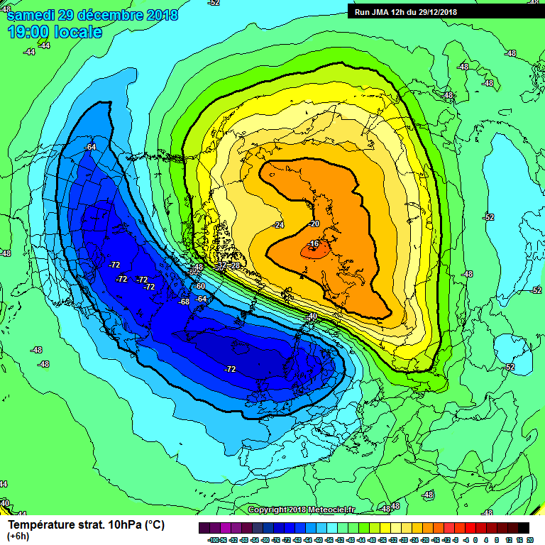
17 minutes ago, Sweatyman said:
pv sounds a bit rubbish sorry mods
Just on that point a lot more knowledgeable posters regarding strat right on this forum rather than a Twitter post with no explanation or evidence.
Also to mention i find gavsweather videos over on YouTube most informative and easy to understand if you want to learn about the strat.
-
2
-
-
With the touted SSW around christmas is it reasonable to think about a sudden swift response filtered into the output. Or are we always looking at a 2 week min lag time for what is going on high up to filter down?
I remember a few years back a dreaded outlook but sudden change and run with it type which materialised (Not to sure if it was strat related though).
Could we we we’ll see this happen post Christmas?


SE and East Anglia general weather discussion 07/11/2018
in Regional
Posted
Morden