


Met4Cast
-
Posts
5,437 -
Joined
-
Last visited
-
Days Won
15
Content Type
Forums
Blogs
Gallery
Events
Learn About Weather and Meteorology
Community guides
Posts posted by Met4Cast
-
-
I know it's FI before anyone shouts at me, however that Northerly has cropped up on the 00z again. And remains with us until pretty much the end of the run.
Interesting to note.
-
Can a moderator delete the silly trolling ramping posts that have started to appear, makes it hard for those who want to understand what the models are actually doing in the reliable time frame, not at stupid number of hours out like 192+ ...... thanks.
It's the model discussion. +192 in within the models, therefore, it's allowed to be discussed here. Looking ahead into FI is handy for trend spotting. Absolutely nothing wrong with it whatsoever.
As for the latest 06Z model. As others have said, no sign of that cold spell at all, and if THIS run were to come off, it'd be generally quite spell of weather, with perhaps nightime frost and fog becoming more frequent.
-
We seem a bit behind on last years values now, then
-
Better if Cyclonic did the updates guys, don't you reckon? - too disjointed to follow otherwise! It was also his idea in the first place, he deserves directorship (if he wants it )
Styx:
Short time contributor, long time reader

I have to agree, it does get quite confusing with images being posted the night before. I like logging on in the morning and seeing Cyclonics morning updates.
Good to see the snow building up more than last year, whether thats a sign or not is yet to be seen.
-
Anyone know if this site has any credibility? Good read if nothing else!! http://www.exactawea...e_Forecast.html
None whatsoever.
-
Uhh, can we please have 3 months of solid snow cover? I'll pay handsomely!
Pay me up front and I'll sort that out for you.
No refunds.
-
Those charts have been subtly changing and to be honest are close to being worthless the further out they go. I wouldn't even call them a guide. I think too much emphasis are placed on these charts.
I agree. Although the Pressure Anomaly charts are generally reasonably accurate 2 months out, I find
-
The atmospheric movements provide the warmth to NW Europe in Winter, not the Gulf Stream, if it was the Gulf Stream we'd be shrouded in fog 10 months of the year and I reckon much more rain. Having a very amateur interest in the weather I find that the Jetsream, the Gulf Stream are interchangeable on for instance the BBC. They are totally different phenomena in fact. The atmospheric heat transfer is what keep us from freezing over most winters. By way of example are we saying last December was because of the Gulf Stream running poorly? What about 1963? Or 1947? If that was the case weather prediction would be nice and simple. Have a read of this http://www.ldeo.colu...tal_QJ_2002.pdf
Answers all questions very well.
For certain this will come up again and again as it is nice and simple argument for sensationalists, very simple cause and affect.
Thanks for posting this - I'm actually having an arguement with someone over on the Daily Mail forum because I've said that even if the Gulf Stream has slowed down, it's very unlikely that it's going to affect our weather. The paper you've posted only helps me prove the point I was making even more.
-
If you class an area the size of France only 'just'.
Just goes to show how hard it is for our little Island to see widespread snowfall. Siberia can see snowfall that covers an area the size of France in just one day, but it seems near on impossible for the entire UK to be covered with snowfall in that time frame.
-
Slightly off topic with regards to CET etc.. but this chart wouldn't be a bad one if we were in winter
Sure, we have a massive displaced Azores High which really isn't going to be good for us if it doesn't move, but what we do have is the first signs of Northern Blocking becoming established, a Western Based NAO (I believe that's what this chart shows with High Pressure near the Eastern Seaboard) isn't the best for us I don't think, but, definitely potential in a chart like this, and definitely good to see signs of Northern Blocking already showing up on the models.
-
More snow across Iceland this year too. I love this thread!
As for the snow moving towards Europe, I wouldn't worry too much yet. We're well up on last years levels already, lets hope we can sustain that.
-
been without broadband for several days so the latest CFS raw output I have is for 9th September
yet another variation, the 3rd so far out of the 5 I've posted
Are those charts available anywhere else other than NW Extra?
-
check this link 4th the cold winter in a row if this is right
The fact that hes basing his forecast on Volcanic Activity throws it out for me. The eruptions were not big enough to have an effect, nor did they produce enough Sulfur Dioxide to begin to reflect sunlight from the Earth.
La Nina/Solar Activity may be favorable as he talks about, but definitely not volcanic activity.
-
Well, unfortunately there has been a substantial increase in magnetic activity from the Sun lately, so if this is a driving factor in our recent cold spells during winter, surely this isn't a good sign?
Whilst the Solar Activity has increased, it is still WELL below what it should be going into Solar Maximum, so I don't think it's likely to be a problem. I also read that sun spots have dropped from the 100's to about 40 in the last couple of weeks or so, how true this is I don't know.
Low Solar Activity is still a key feature, I think a strengthening La Nina combined with a Strengthening -QBO all point to a below average November and December. January is still uncertain, whilst a -QBO points to a colder January, a strengthening La Nina would suggest a milder January. So, maybe we'll see a cross over with colder spells interspersed with milder spells through January, before seeing a milder February.
That's where I stand at the moment, anyway.
-
The winter of 2011/2012 was NOT a cold winter. December 2011 was a
very cold wintry month in many areas but one month does not make up
a winter.
Yes I understand that.
But the overal temperature for the winter 2010/11 came in below average, and the CFS was calling for below average temperatures.
-
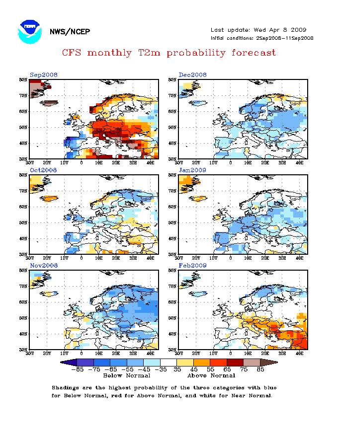
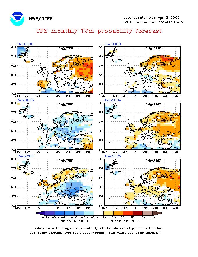
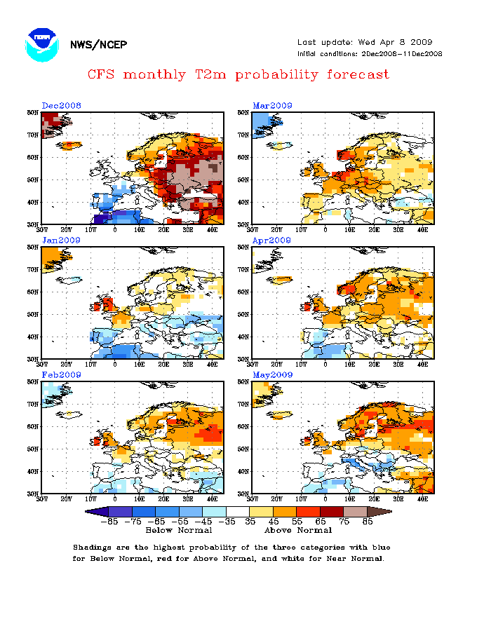
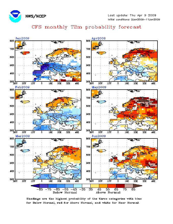
Are we in a virtually identical state to the lead up of the winter of 2008-2009??
For those of you who don't know, 2008-2009 was the first of the real cold winters we have seen recently, snow fell in London on the last few days of October I believe, the first week or so of December saw a real cold spell in Northern England especially the Pennines (29th November to 5th December)
January was another cold and pretty snowy month in the usual locations; Scotland and Northern England; where about 5 days where snowy,
Then of course there was February where the snow and cold was much more widespread and heavy.
Anyway, talking of that Winter, for those relying on the CFS models, they messed up 2008-2009 big time.
Here is the models as of September 2008
http://www.cpc.ncep....uT2mProbMon.gif
^ alright I suppose except for the average forecast February
http://www.cpc.ncep....uT2mProbMon.gif
^ Models in October 2008, even more incorrect
http://www.cpc.ncep....uT2mProbMon.gif
^ November models, one month away from the first cold spell in December, what are the models playing at?
http://www.cpc.ncep....uT2mProbMon.gif
^ models are taking the mick now!
http://www.cpc.ncep....uT2mProbMon.gif
^ January a touch better but February is just totally wrong!
http://www.cpc.ncep....uT2mProbMon.gif
^ All very correct, but its too late now!
So, if ever your planning on using the rather long range CFS models, always wait till a few weeks before hand, after all the independent forecasters have issued their thoughts.
All very incorrect
We have to remember though, that, that was 3 years ago now. The models have been updated, no doubt tweaked and improved since then. They called last years cold winter generally correct in October I believe, I don't have a link to the archived charts and I'm going on memory, so don't hold me to that.
-
ESS?
the purpose of your post is ?
The purpose of YOUR post is..?
The purpose of any of our posts is what? Other than for our own enjoyment?
-
The CFS charts painting an almost identical picture to last winter
Very cold to start with, with High Pressure in the right places. Then towards January High Pressure sinks South, cutting off the cold airflow. The High Pressure shifting South coincides with La Nina strengthening, just like last year too.
So, we could be looking at a near on identical winter to last year, if the La Nina and indeed, CFS forecasts turn out to be correct.
-
All that idiot has done is looked at the CFS long range charts for that day, saw that it was looking average, and based his forecast on that.
Based on the fact that the CFS has been showing colder conditions aswell, I think that forecast needs to be taken with a large warehouse full of salt. That's right, not a pinch of salt. A WAREHOUSE of salt.
(The video that is)The blog however takes both perspectives into account, he looks to average the runs, therefore likely to be much more accurate.
I have to say, before you edited your post I thought that you were calling me an idiot (the blog is mine) so I had replied quite angrily, explaining that I had been watching the charts for some time, and didn't just look at one and decide thats how winter was going to turn out, I then read your edit and quickly deleted my post :lol:
-
Yes I fly Light Aircraft, and whats the Daniel? A sign of winter? Lol
Basically year. The atmosphere over the Arctic is beginning to cool down again. The -10c Isotherm was back around the same time this year. In theory, the earlier the Arctic starts to cool down the better, because it will mean deeper cold will be sitting up in the Arctic come winter which could mean colder weather for us, depending on the type of weather patterns we see, of course.
-
Well surely there must be at least one winter that was cold with a 'strong positive AO/NAO'?
February 1991 had a positive NAO/AO. But we had a Scandinavian High which brought cold snowy weather. Scandinavian highs are about as rare as a dodo these days.
Going to use this thread for my experiment.
Basically every year i monitor when the -10C isotherm retuns in the Northern Hemisphere and compare it to the current year.
You could argue that it will make no difference come winter however logic to me dictates that the better the head start, the better in terms of there being more cold to displace to mid-lattitudes.
GFS6z suggests that 31st July could be our date this year.
It's back!
-
November looks a bit bloomin' cold
I know I know "The CFS change all the time" but they were pretty much spot on last winter from what I can remember, plus, it's been consistent in forecasting cold for November.
What do you guys make of it?
-
Maybe Im just not as bogged down in weather models as some peeps. The atlantic is about to wake up from its slumber, I am neither a snow ramper or a cold ramper, does it actually scare sp,e peeps to know that some people just know..... its called intution.
Hello
I do seem to remember you getting the last two winters generally correct, and I remember talking to you about intuition saying I had an the same thing before a cold winter, yours seems to be calling for a warm and wet winter, mine is calling for a cold and snowy winter. I wonder who will be right?
Obviously I don't base forecasts COMPLETELY on intuition, that'd be crazy. Based on the current ENSO forecasts, Solar Activity, SST Anomalies, Pressure Pattern Anomalies, etc.. I'd say that we're more than likely going to see another cold winter, possibly similar to last winter, starting off very cold and snowy before settling down and becoming a little more closer to the average/slightly below average. Though I do expect we'll see more cold spells spread throughout winter, rather than having it all at once.
It'll be interesting to see whether science or intuition wins out
-
Going to use this thread for my experiment.
Basically every year i monitor when the -10C isotherm retuns in the Northern Hemisphere and compare it to the current year.
Modelling suggests that we will not have it before the 24th at least this year (based on GFS out to 180 hours).
So, using 1st August as a point to aim for, we have the following years (since 1998 because that is how far northern hemisphere charts go back)...
2000: http://www.wetterzentrale.de/archive/2000/avn/Rhavn00220000801.png
2002: http://www.wetterzentrale.de/archive/2002/avn/Rhavn00220020801.png
2003: http://www.wetterzentrale.de/archive/2003/avn/Rhavn00220030801.png
2007: http://www.wetterzentrale.de/archive/2007/avn/Rhavn00220070801.png
2010: http://www.wetterzentrale.de/archive/2010/avn/Rhavn00220100801.png (earliest cold pooling since at least 1998)
You could argue that it will make no difference come winter however logic to me dictates that the better the head start, the better in terms of there being more cold to displace to mid-lattitudes.
GFS6z suggests that 31st July could be our date this year.
GFS has the -10c Isotherm as early as the 22nd, but by the next chart its gone.


 (The video that is)


Model Output Discussion - Early October Onwards
in Forecast Model Discussion
Posted
The problem with that, is FI constantly changes. At times last winter, FI was at just 48hrs