


lorenzo
-
Posts
4,875 -
Joined
-
Last visited
-
Days Won
25
Content Type
Forums
Blogs
Gallery
Events
Learn About Weather and Meteorology
Community guides
Posts posted by lorenzo
-
-
Great Blog Post here from the Capital Weather Gang contrasting recent climatology with historic set up.
-
 1
1
-
-
- Popular Post
Nice looking MJO Plot from the UKMA - control run and UKME - Ensemble run (shaded).

ECM still not keen on the 6-7-8 orbit, perhaps reflected in the latest weekly? GEFS however is.
Phase 6 analogs
Phase 7 analogs
And if UKMO delivers on it's projection with a sustained period of time in Phase 8, analog has a significant ridge which may be the straw that breaks the camels back as far as the vortex is concerned..
-
18
-
-
2
-
-
Yay - nice fat heavy snowflakes here now.
-
Just another breezy day ! Previous windstorms this month have packed a stronger punch from an IMBY perpsective, however clearly still very strong winds to come further North and Northwest.
Looking through the Norway sat loop. Looks like the parent low used up a lot of it's 'oomph' absorbing / interacting with the other sister low overnight, whether that is a reasonable enough explanation for the final depth of the system - who knows.
The morning Fax highlights a further area of Low Pressure directly south of Greenland, and the mass of cold stratospheric air deflected further south, vs immediately funnelling into the main low.
Looking lively on the radar and a few Cb visible on Sat rep latest report.
Mon the Snaw..
-
6
-
-
What a shift BUS, didn't notice your post at half two a.m, busy with the wee guy who decided to have another all night rave. Nothing to do with Santa arriving, just because he likes being up all night most of the time..!
Snawbag ® (Scottishskier) not as deep as predicted on last night GFS run, Meto Faxes from this morning and for midnight.
Even without the depth, that's a solid 18 hours of potential gales.
Snawbag ® delivering healthy Snaw for some parts, turning to sleetbag elsewhere.
South Uist has reached 75mph, Cairngorms at elevation exceeding 100mph. http://www.weatheronline.co.uk/weather/maps/current?LANG=en&CONT=ukuk&LAND=SCO&KEY=SCO&SORT=3&UD=0&INT=06&TYP=windspitzen&ART=tabelle&RUBRIK=akt&R=310&CEL=C&SI=mph
Friday looks to have calmed down a bit also with less of an extreme solution present on the morning model output, gone are the c930mb depths.
ECM / GFS / UKMO
So, Snawbag ® not as violent as Bawbag, which in all honesty am pretty happy about as it means many folks can enjoy Xmas Day tomorrow without other concerns, still a pretty wild day out there..
-
6
-
-
-
1
-
-
Fantastic post LS - Bet you are glad you weren't on a connect flight via any of the London airports tonight !!
-
1
-
-
Tomorrow's headlines, think the Daily Star has some words on it's front page somewhere..
-
2
-
-
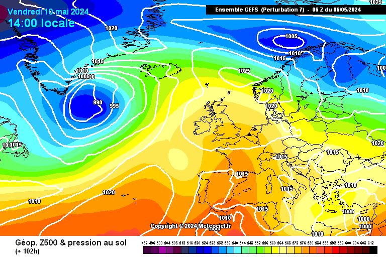
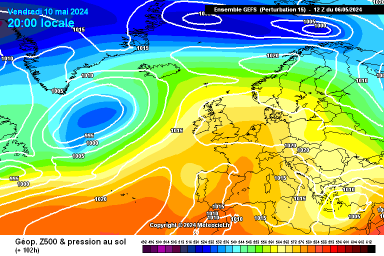
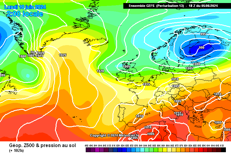
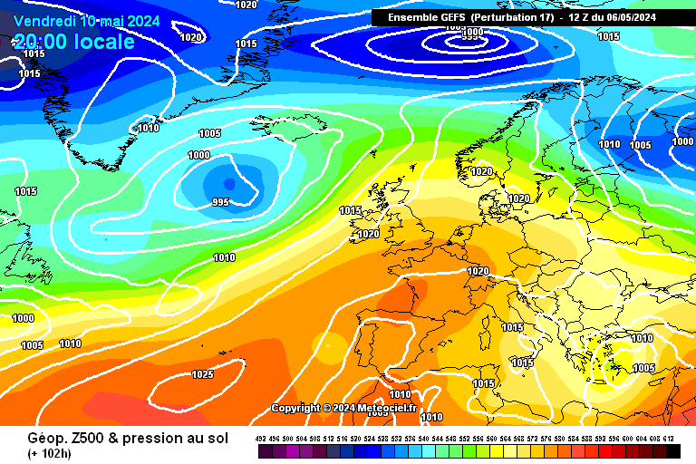
Some outrageous charts in that run for Friday night..
http://modeles.meteociel.fr/modeles/gens/run/gens-7-1-102.png
http://modeles.meteociel.fr/modeles/gens/run/gens-15-1-102.png
http://modeles.meteociel.fr/modeles/gens/run/gens-13-1-102.png
http://modeles.meteociel.fr/modeles/gens/run/gens-17-1-102.png
-
2
-
-
Good spot by Liam, Friday's ensembles from tonight..
http://www.meteociel.fr/cartes_obs/gens_panel.php?modele=0&mode=1&ech=96
-
1
-
-
Hey people,
Im in north west highlands, 956mb at mo and just waiting for it to fall....this is getting weird now, calm outside and i can feel something is coming yet alone know. caught the last few gemanoids (sp?) tonight through a gap in the forest. they are so beautiful!
Anyway, i very kindly had an invite here and just wanted to say its a pleasure to be here...now back to storm watching...does anyone think the depression that follows tomorrows is worse for us up here?? the eye lands right on us?
Tris
Welcome along lupe, helluva time to join - you've got some serious winter weather up and coming!
-
2
-
-
- Popular Post
- Popular Post
From the severe thread, mesosphere spotted this wayward flight from Stockholm.
Pilots not fancying landing this evening...
-
10
-
Just had a wee peek and looks like BAW781C from Stockholm to Heathrow has opted for a go around, up to FL80 now.
current heathrow metar: EGLL 232150Z 20025G38KT 9000 RA BKN016 BKN020 12/10 Q0981
terminal forecast (probabilty 30%) going for gusts of 53 knots from the S/SW. I wouldn't want to be landing an aircraft in that!
Well spotted, surreal looking path that flight has taken?!!!
-
4
-
-
#ukstorm now trending on twitter. Saw a Tweet that referred to an air hostess mentioning on facebook - roughest landing of her entire career and never seen so many sick bags.
Aircraft looking pretty stacked over Heathrow and Gatwick..
-
Snaw and Wind charts from the 18z.
Also, for a wee browse some amazing images in here a couple of good weather ones hidden within..
http://gizmodo.com/the-100-most-astonishing-images-of-2013-1486472299
-
2
-
-
Why settle for one sting jet when you can have two...!
-
7
-
-
New thread, I think we might get busy on Xmas Eve.
Enjoy http://forum.netweather.tv/topic/78858-scotland-regional-discussion-231213/
-
2
-
-
- Popular Post
- Popular Post
Time for a new thread as it is going to get quite busy in the next 24 hrs as our latest Atlantic storm deepens and high impact weather expected for much of Xmas Eve.
Gales, Snow, Thunder, Lightning - the whole works.
Let's please draw a line under the media bias debate and use the relevant thread for commentary on this, whilst I agree with points on both sides of the argument, it really detracts from the thread and creates an unnecessary atmosphere.
Travel safely and keep an eye on the Met Office and Travel updates.
Wishing you all a very merry festive period.
Friendly banter, preferably about the weather but as always not essential for this thread..
Let's go...
-
12
-
Getting bored of this... can we please move on.
On the other hand, I can report the delete button is working well.
-
8
-
-
Sting Jet forming (play animation) http://www.zamg.ac.at/cms/de/wetter/satellitenbild-animation
Nice link, you can also see on Eumetsat Water Vapour imagery the system ingesting the cold air.
Now at 938mb on latest surface chart.
-
3
-
-
Nice GIF of this week as seen by the GFS from Dr. Maue.
Also check this buoy reading... pressure dropping off a cliff. http://www.ndbc.noaa.gov/station_page.php?station=64045
-
2
-
-
Completely agree BMW, please refer to the forum guidelines.
Netweather community guidelines/rules
If your post content, signatures, profile images, etc. are disruptive and impact other members enjoyment of the Netweather community we may ask you to refrain from such actions or revoke your access to this community or features within it.Trolling simply isn't acceptable, and nor is posting in order to attain your post being deleted or wiped out.
The moderators on here do this in their own time, and don't have time to put up with folk being a.r.s.e.h.o.l.e.s.
Am looking forward to some exceptional weather, not a deluge of b.s from folk on the noise up.
Please consider the wider community who use the site.
Thanks.
-
6
-
-
RE: Sting Jet, need a Met. to answer if there is potential for one in this system, am unsure how the interaction with the descending dry air with the area of low pressure further west impacts development.
This animation shows the 2012 New Year storm Sting Jet.
Link here http://cimss.ssec.wisc.edu/goes/blog/archives/9502
-
5
-


Scotland - Regional Discussion - 23/12/13 >>>
in Regional
Posted
Not long to wait for the next storm to chase #Erich this time - Another wonderful name from the FU Berlin folks..
Would be nice if UKMET had a similar scheme then we could get some colloquial cyclone names.. Wonder how this one is shaping up on the still vigorous jet profile, soon find out on the 12z..