


lorenzo
-
Posts
4,875 -
Joined
-
Last visited
-
Days Won
25
Content Type
Forums
Blogs
Gallery
Events
Learn About Weather and Meteorology
Community guides
Posts posted by lorenzo
-
-
ECM follows the GFS with the storm track for Thursday.
951mb low.

-
ECM goes with GFS and sides with GME against the UKMO / GEM solutions.
ECM /GFS
Amber warnings tomorrow? depending on how the 00z see things, expect the 00z to catch folks attention wrt the timeframe plotted bang on peak bombing of the system.
-
 1
1
-
-
The scales are not the problem. Its the date.
You have made the composite from 1.1 to 13.12. This is the actual mean so far for December.
And this is the daily mean for 30/12, from the year collection in Chionos composite form the first post.
Glad you are around to keep me right Recretos
So, as an added bonus / distraction, in my original post that was 2013 so far 30mb heights ! -
1
-
-
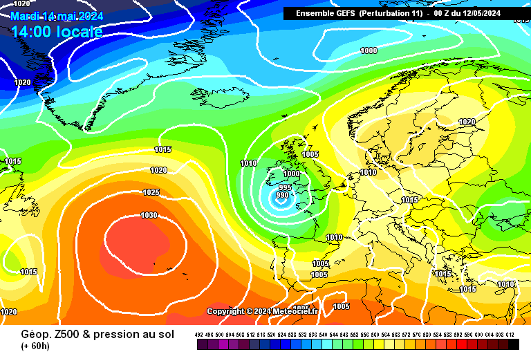
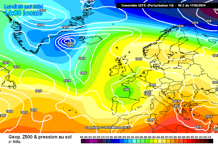
12z take on Thursday's low. GFS / GME deepen the latest Atlantic Beastie. UKMO less intense and GEM a whole lot slower with the Jet.
GFS / GME -
UKMO / GEM -
Over to the ECM, due to the 24 time steps, we will be looking at the equivalent of these time frames on the GFS and missing the most intense phase of deepening of the low.
-
3
-
-
Ouch...devastation if that occurred (worst case scenario)
http://modeles.meteociel.fr/modeles/gens/run/gens-11-1-60.png?12
Not far away from the GME/DWD projection.
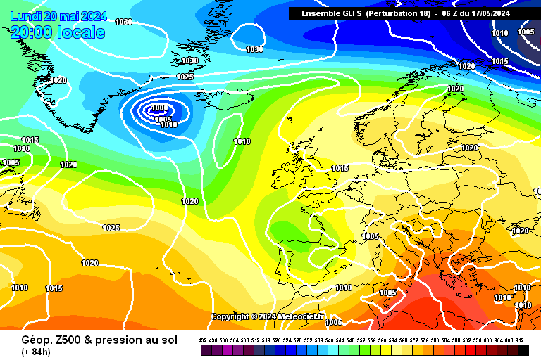
GFS / GEM / UKMO
Quite a variety of solutions and looks like this will be all about timing with respect to how deep rapid cyclogenesis takes the system, which in turn looks to be decided by how fierce the jet it is. GFS as one may expect given it's bias for feedback and deepening of lows in the extreme. GEM which we have seen dartboard happy over the last couple of months sees a slower evolution.
With our experience of not trusting output until the UKMO is on board, over to the fax output !
-
4
-
-
That's 100m/s which is around 224mph........
Remember to check the scales, Tony!
No chance, avoid them at the gym at all costs !
Did notice the scale was slightly different with the monthly composite having a higher range, was thinking more about the geography of the anomaly, with heights concentrated more on the Kara vs East Siberian sea. Either way the vortex is the important part of the puzzle, and it's bang on.
-
1
-
-
Re: Weaker vortex and Wave 2, Recretos made some excellent analysis on this very point a couple of posts back.
Looking at Chiono's very first post and the composite for December and in comparison with December to date, could we be a little bit further on than predicted at this stage? With the vortex tightening wondering if it is using up all it's winter juice more quickly than usual?
Looking at the zonal wind profile however, it certainly isn't messing around.
Next few charts show the heatflux and wave 2 peaks in current output and a gif starting at the top of the strat. down to show there impact.
Think we may need an anomalous Siberian ridge or any kind of Greenland ridge to eventually get in about this Winter's vortex.
-
2
-
-
- Popular Post
- Popular Post
This morning's cloud cover and showers soon disappeared and its a lovely looking day outside now with wall to wall blue skies and sun. Temperature has dropped about a degree, or even two, since this morning and with the breeze I suspect it will feel on the chilly side for a change.
Popped in and read the last few pages of the model thread for the first time since Thursday. The obsession of finding anything resembling a cold chart is striking, although admittedly the stormy synoptics being offered up did at least seem to be getting more attention than they usually seem to.
Model thread into winter is the Hunt for Cold thread, which is fine as this seems to be what the majority of folks like in Winter - the potential for Frosts and copious snowfall.
Where it gets tricky to read is in times like now where there is a bit of a N-S divide, our latitude helping by keeping us on the cold side of the jet and subject to colder air and more traditional winter synoptics. Can totally understand the frustration felt by folks further south, especially when that eurotrash high is sloping around. I think the upcoming active Atlantic phase will be enough to keep everyone pre-occupied.
Guess what I am trying to say is that this is where the regional thread is brilliant as we can ramp away about storms and possible polar maritime incursions in here without grating anyone else !
Definitely into a cooler airmass now, feeling quite sharp out there today when the wind picks up. More wintry element to the higher clouds also.
-
10
-
- Popular Post
- Popular Post
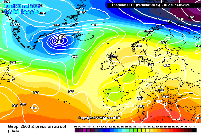
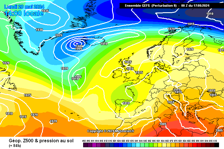
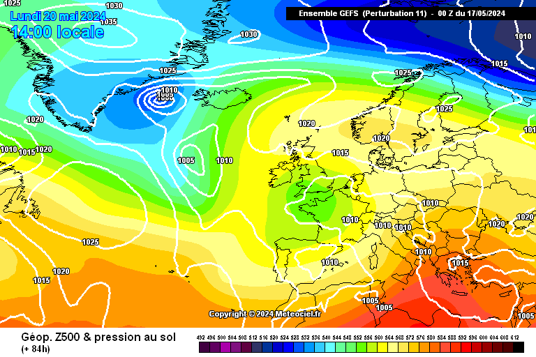
Thursday beginning to look pretty extreme. Many ensembles deepen this low to 935-940mb
http://modeles.meteociel.fr/modeles/gens/run/gens-15-1-84.png http://modeles.meteociel.fr/modeles/gens/run/gens-9-1-84.png
http://modeles.meteociel.fr/modeles/gens/run/gens-11-1-84.png http://modeles.meteociel.fr/modeles/gens/run/gens-14-1-84.png
http://modeles.meteociel.fr/modeles/gens/run/gens-18-1-84.png
GFS 18z has now trended toward the 12z ECM and another uberlow on Xmas day.
WIld, wild charts, odds on a white xmas falling if these came to pass.
-
10
-
Hopefully the fu Berlin will get their stuff sorted out tomorrow. Looked about on the web and it looks like the material from ECM is not available anywhere else.
Some poleward EP Flux on the stratospheric plot on the JMA Page was the most interesting thing I could find today.
-
Strongest part of jet perfectly positioned to engineer that low.
-
3
-
-
What a horrible week and weekend, was on travels last week, Scarborough, Milton , Nottingham, and it was wet from start to finish for the most part, and the weekend was one for staying in bed, with a few whisky's.
Last nights thunder was a surprise, I thought a lorry had crashed through ma door, but I never saw the lightening, but got this from FB.
Amazing pic Cheggers - great find.
Whilst GFS wants to take us back to the euro high solution, tonight the ECM serves up this..
913mb..
-
5
-
-
ECM has the Christmas low at sub 915mb (913mb on the higher res, but the public offering has it sub 915mb), its just that Meteo can't handle pressure that deep.....
Scary really.
Unbelievable.. Braer Storm all over again.-
2
-
-
Got time to watch this programme today. http://www.bbc.co.uk/iplayer/episode/b03l5lvh/One_Wild_Winter_in_the_Scottish_Mountains/
Brilliant and very poignant, really worth watching if you missed it earlier in the week.
Good to see Scotster in there too along with some great footage of the highlands.
-
4
-
-
Met Office warnings updated just now for this one..
-
Met Office warning out for Thursday. Very quick off the mark with this..
-
Windspeed starting to pic up a little out there now.
The nearest LP reading 955mb on the latest surface plot.
K5 Data http://www.ndbc.noaa.gov/station_page.php?station=64045 33.8 ft wave heights !!Hurricane force 12 on the shipping forecast. Wild.-
1
-
-
A trio of sub 960mb lows in the latest surface plot. UKMO for comparison.
Hurricane force winds into Bailey and accompanied by many more warnings..
http://www.metoffice.gov.uk/weather/marine/shipping_forecast.html#All~Bailey
-
1
-
-
GFS relentless with the uber lows.. Continues firing the out on the 06z.
Wonder where the UKMO and ECM will see things this evening, another 'lively' week.
Mean Jet at day 10 from ECM
-
3
-
-
Found this earlier and it is a great site, extremely hypnotic, so HC beware
http://earth.nullschool.net/#current/wind/isobaric/1000hPa/orthographic=-5.98,39.26,512
Click the word Earth and a menu opens for other levels in the atmosphere, you can also click and drag the globe around.
-
3
-
-
An interactive globe to highlight wind flow.
Great site. http://earth.nullschool.net/#current/wind/isobaric/1000hPa/orthographic=-12.66,43.60,512
-
6
-
-
Not to my knowledge, ECM server needs a kick now and again..!
Found this though..
http://earth.nullschool.net/#current/wind/isobaric/10hPa/orthographic=-2.93,84.73,512
-
4
-
-
http://www.wunderground.com/weatherstation/WXDailyHistory.asp?ID=IFOMIDVA2&day=14&year=2013&month=12
Faroes dropped to 935mb as that system passed North of the country.
Amazing reel on yr no a trio of weather bombs. http://www.yr.no/satellitt/europa.html
-
2
-
-
No escaping the weather.. just when you think you have had enough for one day and try to get some zzzzzs
-
3
-


 You have made the composite from 1.1 to 13.12.


 So, as an added bonus / distraction, in my original post that was 2013 so far 30mb heights !


 Unbelievable..


Scotland - Regional Discussion 16/12/2013 >
in Regional
Posted
With the Atlantic super charged and delivering low upon low, a really active end to 2013 ahead, thought it best to kick off a new thread as we approach 2014.
Amazing number of hits on the last thread, and great to see this remain a really popular place for real-time discussion of Scottish Weather, thanks to all the regular contributors and would also like to extend a warm welcome to those of you who look in, and are yet to join in, the more the merrier.
45 pages , 25 K views. Great work folks !!!
On to a new thread for the countdown to 2014 here..
http://forum.netweather.tv/topic/78776-scotland-regional-discussion-16122013/