


Jeremy Shockey
-
Posts
830 -
Joined
-
Last visited
Content Type
Forums
Blogs
Gallery
Events
Learn About Weather and Meteorology
Community guides
Posts posted by Jeremy Shockey
-
-
 ECM 0z ensemble mean
ECM ensembles trending colder after a very brief mild blip. A good mean this morning
Op even interested in something very cold around 15th
-
 8
8
-
-
ECM 0z ensemble mean
The Op was one of the coldest in the later stages but the mean is not bad ( after the mild blip )
An improvement in the medium term for coldies as we enter the second half of the month
-
2
-
-
GEFS 0z ensembles
things remaining fairly chilly according to the GEFS 0z ensembles after a brief mild spell
it will be also very interesting to see the ECM ensemble mean ( later ) after that good ECM 0z Op run
-
7
-
-
Just had a heavy shower in North Newbald that was all sleet , temp still 1.5 c here and dew point of 0.4 c ( the higher Wolds are getting a pasting of snow though )
-
2 minutes ago, Liam Taylor said:
What South Yorkshire
i hope you guys will see something out of it too but i am worried that it runs out of steam a bit after Northumberland , Durham and Cumbria
-
5 minutes ago, Maltonman said:
Any news on the band of rain/sleet and snow coming south on Thurs/Friday? Are we expecting any potential surprises?
It looks promising for North and West Yorkshire , but poor for East again.
That is a decaying front so may be patchy by the time it hits us. ( one to watch )
-
1
-
-
snowing again on top of the Wolds now at 240 m ........but even if you go down to 200 m it is sleety / rain grrrrrrr
-
Nice up top of the Wolds this afternoon
-
4
-
-
Blizzard up at Cot Nab on the Wolds right now
-
2
-
-
1 hour ago, vizzy2004 said:
My side of the Wolds has snowcover this morning James.
Thanks Andy , i might cycle up to Fridaythorpe later , it will be a bit dicey and a long haul , but probably worth it , James
-
Very disappointing again overnight !
Fri looks to be our next chance ( although it is a decaying front ) moving South.
It will probably run out of steam as it approaches Yorkshire. ( i'm getting a bit weary of this chase now )
Aperge 0z Fri 8th
-
2
-
-
Another sleety shower at 04.30 but no intensity ( and moving through too fast )
The main band of showers ( “ stream “ of sorts ) is much further North and not delivering snow there either yet.
another bust for East Yorkshire sadly.
-
Scott ....... do you ever sleep mate ?
-
The odd sleet shower here but no snow yet at 4 am.
-
Just for fun......Predictive radar on Accuweather showing streamer hitting Grimsby at about 10.30 ( will then move North throughout the night turning more Wintry)
-
5 minutes ago, vizzy2004 said:
Every shower getting more and more wintry now. Hoping for all snow here by 10pm, getting it to settle will be the hard part though as showers are rattling through very quick and aren’t packing much punch.
yes agreed Andy ( just been on top of the Wolds 25 mins ago ) and had a heavy sleet shower with hail mixed in. Give it another 5 -6 hours and a drop in temp and we could be in business. ( especially if we pick up one of those streamers in the early hours )
temp now 2.1 c , dew 1.4 c
-
just had a heavy sleet shower which is a good sign for later tonight ( given that it is 4 c with a dewpoint of 3 c now at 2 30 pm ) and my elevation is only 50 m asl
-
if you right are under the intensity of the streamer between 3 am and 9 am with the -8 isotherm over you then it will be probably be snow ( the dew points do look a bit iffy so if you just miss the main streamer then it could be rain or sleet ) .......in my opinion
-
1
-
-
As a rough guide , this streamer could be 50 miles further North or South but looks very promising ( if it hits you ) between 0300 hrs and 0900 hrs tomorrow morning,
i just pray for those in Hull and Beverley and all my snow loving friends in "snow starved E Yorkshire" that they get lucky this time
-
1
-
-
Harmonie 0z
WRF NMM 0z
Dont worry the streamers are still there for Yorkshire and the 850's will be -8 at 4.00 am on Tue morning. The Dew points are also likely to be more favourable than they have been in the last 36 hours . This is the best shot for East Yorkshire but still marginal near coasts and it would be helpful to have a bit of altitude as normal.
-
4
-
-
Was in Hull 50 mins ago and it was 4.5 c and murky with drizzle , no chance of snow ...... let’s hope our Hull friends get something white very soon
-
2
-
-
Harmonie 6z prec.
When one of these streamers hits Yorkshire on Tue morning there is going to be some fun. ( especially when you consider that the -8 isotherm is across most of Yorkshire by then )
-
1
-
-
GFS 6z short ensembles
Very cold up to 9th Jan ........ enough said
-
6
-
 1
1
-
-
GEFS 0z ensembles
ECM 0z ensemble mean
A lot of spread from both sets of 0z ensembles this morning and much uncertainty after 9th Jan ( with the trend of some warmer 850 hPa temps )
However plenty for coldies to get excited about in the next 5 days with the highest probability of widespread snow chances for the UK since 2018
-
2
-
 ECM 0z ensemble mean


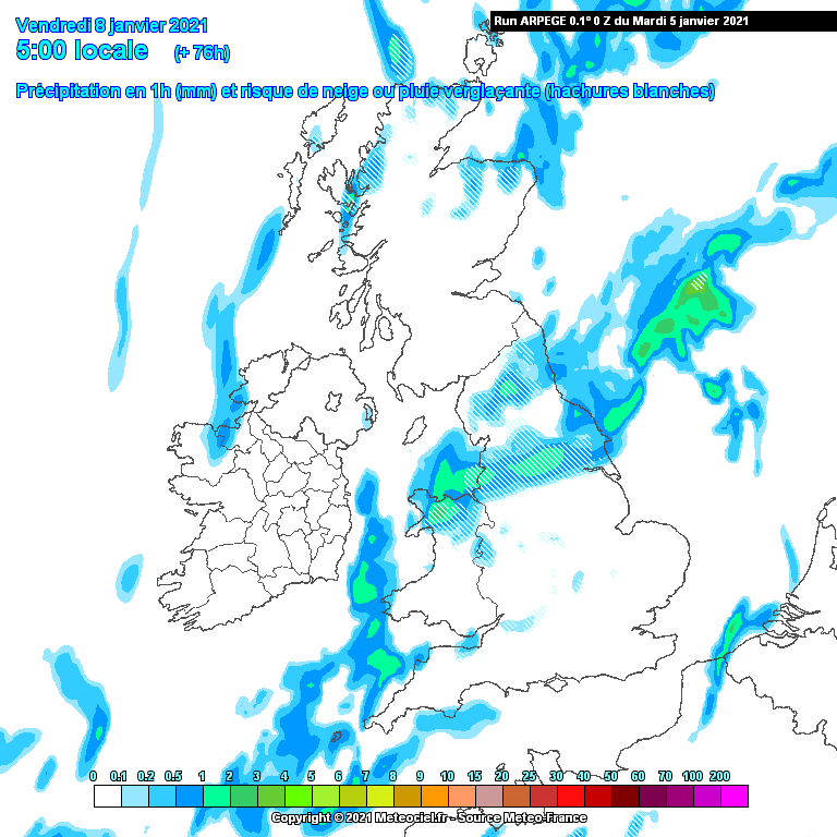 Aperge 0z Fri 8th


 Harmonie 0z
 WRF NMM 0z
 Harmonie 6z prec.


 GEFS 0z ensembles
Yorkshire and E England regional discussion
in Yorkshire & E.England Weather Discussion
Posted
i saw that too .......snow to rain event mostly for high ground i expect ( not for Hull and East Yorkshire sadly ........our time will come )