


The watcher
-
Posts
1,842 -
Joined
-
Last visited
Content Type
Forums
Blogs
Gallery
Events
Learn About Weather and Meteorology
Community guides
Posts posted by The watcher
-
-
Don't come back till you've wrapped that one up with a 147 in the last, a session to spare and a promise from Michele Tabb.
I got wrapped, played alright but opponent played better. Too much Whiskey involved. I love Michaela Tabb
watching the Nolan show now, all I can say is good job I have a job in the morning, not like the cohort on that show. I think it would be cheaper to send everyone on a foreign holiday, and I don't mean Benidorm. People need to open their horizons, I have more English friends and connections as do most Dubliners than Belfast people, what's all this Protestantism Catholicism about the world will never know. What a dreary place.
It's indeed a subject for the minority of people, but lets leave it at that and us majority folk get on with forecasting this nonsense lol. After all, our weather is the same.

-
I have to step in folks. I know its a tough and anxious time for us all but we shouldn't discount anyones forecast with so much uncertainty. In respect of met.ie I think we should leave all criticism aside until such times as they are proved wrong. I'm half hammered in the middle of my snooker match, can't be dealing with poop hitting the fan right now.
*Edited for Whiskey spelling mistakes*
-
So things are changing?
They always are with the weather on our wee Isle, but more so at an early timeframe at the minute with things very much on a knifedge between cold and mild.
I'm having a whiskey now, good old Jack D, and happy because the festival I normally go to had a 30+ band announcement today and it was very good. Got a snooker match in just over an hour so hopefully won't be doing an Alex Higgins tonight. lol
I'm in a good mood today regardless of the output.....health and happiness are on good terms with me at the minute, and no I haven't pulled.......yet.
Ah sorry I didn't realise that! They did the same yesterday at that time. Don't understand them issuing warnings just before the 12z is due out.
If the meto output this afternoon was based on models 06z then with Murrs "missing data rule" surely we could count the 12z's as more reliable, and meto haven't updated for them yet.
-
Either Dew points will get too high (with the moisture content of the air) or thicknesses are too high. However, with today supposedly being rain (and seeing sleet instead) maybe the conditions don't need to be as favorable as we would usually consider for snow risk.
The weather warning says rain but the computer says snow.
To them, computer says NO, but there updates might be a little behind as they have to go through all the hassle of getting verification by chief forecaster. I notice that their updates in the 48hr + area tend to be on output 6-12 hours previous.
-
Noticed Neiller, eastern Ulster in the firing zone again...
Co, Down, Co, Down...
I edited it ^
I'm going to do a little research later into Weekends potential. I need to see what today's stats are as instead of rain, I have sleet. So If I compare to what Friday/Saturday sees I might have a better understanding of what may or may not occur.
-
Northern Ireland Weather uses pretty much what we have on here to forecast. Have seen them post GFS charts a few times.
-
Usually in the 24 hour period is when we see firm up on location for a frontal system. I'm excited slightly now, but if it looks good Thursday I'll be posting ramps galore. Would still like the colder uppers further West so we all get in on the action though.
-
GFS has the cold lingering on for a good while, even here and in outbursts in the furthest West parts of Eire. Surely with so many sliders, undercuts, fronts, battles, etc going on over a good period, we'd all see some white stuff?
It's almost like a model boxing match with all these descriptions (undercut, battle, slider).
-
Northern Ireland could possibly do well out of that too - hope so for them guys. Quality undercut.
Maybe that'll keep the silly protesters away.
Knife edge stuff for our wee Isle and Ireland at the moment. Exciting times ahead and hopeful that the Eastward progression from GFS 06Z does not come back to haunt.
-
It's as knife edge as it comes, with our Island only being 100-150 miles across. Starting to see early warnings and some forecasts, but still the uncertainty remains.
-
some great charts tonight people. even if the atlantic breaks through its not gonna last for long. heights look to be building over greenland on latest ecm run and also an artic high. pv gonna be obliterated in 10 days. interesting times ahead.
My favorite phrase. Make it happen tropo, or I'll have ye.
-
Crazy, absolutely crazy charts. A quick look would make you think an Atlantic storm and zonal was on the way, but a second glance shows the HP to the NE Exerting more and more influence. We want it West, but too far West and no precipitation, too far East and no snow. The battle ground hasn't been far away from Ireland the last few days of runs, a little further West and it'd be perfect for ALL IRELAND
to catch some. That's my ramp for the day .Oops, forgot to say that Bangor has seen alot of shallow convection today with sleet and hail showers quite frequent. Pretty good for literally 20 meters from the coast.
-
GFS looked better initially with heights but in reality Atlantic further east compared to q8z at T18z.
The output has been terrible in terms of Ireland for cold and snow this season and continues to do so. We just don't do well very often on an Easterly. Battle sets itself up in the Irish Sea around days 4/5 on this run.
-
No correction West on the 00z GFS, things probably more East slightly. -5c line hugs East coast for about 48 hours but beyond that it's back to same old. Back to the drawing board for us in terms of looking for snowfall chances beyond day 5.
Looking now for the first possible signs of a change in pattern to low heights in Scandi and heights to our NW, sick of the Easterly chances. Just a Northerly will do.
-
Ireland is a very hard place to get sustained cold into, it's very rare here. Last 2 I remember were 2010 and 1995. Other times have been a 2/3 day spell. Don't get me wrong, it's great to see the snow, but no point if it's not going to settle for more than 24 hours.
Unfortunately this spell over the next 5 days is not of that type for us, any snow will melt away in 24 hours or less (apart from highest peaks). I wouldn't however write off the winter yet, we just need that HP to be over Greenland proper, bringing in a strong Northerly, then for it to either join/stretch East to Scandi and bring in a NE/East spell second. The coldest spells in Ireland usually start with a strong cold flow and then an anticyclonic spell and lying snow.
-
The fact that some have already seen snow in what was expected to be rain is a promising sign for things to come. Not sure what the precipitation was here in Bangor, will have a look at radars now and see.
Broken links SU.
-
Su Campu, can you see if I have an account on boards.ie? Would be under "The watcher". Was going to join the other day but wasn't sure if I had an account already or not. I was wondering what your username meant and searched it on google, it came up as a mod name on boards.ie. Handy.
-
I've a second hand one at my mums that needs taken down.
Sends data to your PC and graphs it out too.
Not sure how much I'd put on it now though.
-
Haven't seen any snow since December 2010, not even falling snow.
-
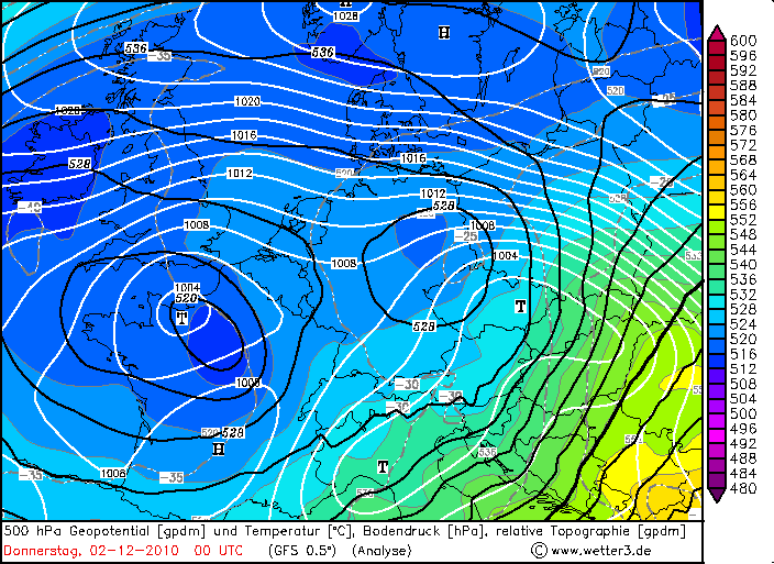
That chart shows 500 hPa geopotential, not thickness. Actual thickness over Ireland at that time was 516-520 dm, as shown by this analysis (colour-shading is thickness, black line is 500 hPa geopotential).
Just checked again and you are right "1000-500mb thickness (DAM) less than 522dm, lower if you are on the coast, but as high as 540dm it is possible in a heavy shower, but unlikely."
Seems I got mixed up with the 2.
-
I've never known it to snow in Ireland with 528 dm thicknesses unless there's already a cold pool in place. 522 is really the benchmark for a setup such as we are looking at in the next few days.
Well 2nd December 2010 as an example:
Nearly a similar synoptic as what we are looking at the next few days but with things a tad further West and the Atlantic knocking on the door. You are right about the cold being embedded, but this would have an effect on lying snow rather than falling.
-
Good post by Stormforce and backed up by BFTV.
Those are the 3 main things I look at when determining snow risk. 850hpa at or below -5, dewpoints at or below 0c and 500 heights at 528 or below.
Anything greater than these 3 (2c higher 850, 1c higher DP and 530dam) is marginal snowfall but can still happen.
I know John Holmes has a guide in the learning section which includes other factors (freezing level, 2m temps) so if you need any more info pop on over. The 3 mentioned though are generally enough.
-
Yep Skywatcher, they have switched them off for the time being to save Bandwidth, which is why (maybe you could all do it too) I'm putting my location in my signature.
Don't think you have a warning point MS, can't see it on your profile. Warning points are usually omitted on reported posts.
Yes, GFS is marginal for Ireland, but we still have time for changes. The last ECM run was 2c lower in 850's for Ireland. We might scrape another couple of degrees off the 850's on the next 1 or 2 GFS Runs. With 3 days still to go and upwards....we could easily see more correction West....or in bad terms, east. I favor the West option though.
-
Please kepp on topic as the mods have been stating all evening! Moaning and general chat threads exist to discuss your grievances re. garden centre managment! Thank you!
Hi Sandra, best leaving it to moderators of the forum to say that. Just causes more clutter.
Welcome to the forums though, and don't worry about Ireland, -4 to -6 850's can be low enough for snowfall. Bring yourself on over to the Ireland regional forums for a more IMBY analysis on what the models show. It's in regional discussion area.


 to catch some. That's my ramp for the day
  .
.

Ireland regional discussion 21/12/12 and beyond
in Regional
Posted
Snow yayyy, sore head noooo.
Mite get a day off tomorrow then.