


A Winter's Tale
-
Posts
4,194 -
Joined
-
Last visited
-
Days Won
6
Content Type
Forums
Blogs
Gallery
Events
Learn About Weather and Meteorology
Community guides
Posts posted by A Winter's Tale
-
-
Im expecting an active Atlantic through sept and oct, more especially mid sept up to and through the most part of october, some deep lows forming soon, but i expect potent lows mid atlantic to buffet the UK, most likely mid sept onwards, using tropical energy as the feeder, the jet stream taking the lows or gales on a fast track into the North sea and maybe Low countries. i do see an early winter pattern evolving at end of oct and november start, with low pressure bringing a North wind across all areas, this being the start of real cold and snow..
We had our winter in December 2010, We had our summer in April/May 2011 and how about we have our winter in November 2011.
Coldest November ever anyone? A White Bonfire Night?
-
Here, tonight- or at least before the end of September. With a record early frost 2011 might just escape the "most boring year ever" tag. Even 1998 and 2002 had there epic wet months, 2008 its record dull August (which 2011 won't quite beat I reckon), the snowless year of 1992 that fantastic May. The only other thing that can rescue it now is a December to rival 2010- and there's my numbers on the Euromillions tonight.
If anyone thinks April means 2011 should escape this label look at my sig.... 2007 absolutely murdered 2011 for sunshine round here.
Hmmm:
Jan 2011 - Some snow for Scotland and a big storm.
Feb 2011 - Very Mild, Spring arrives early
March 2011 - Quite potent cold spell for Scotland, Amazing snowfall in Highlands
Arpil 2011 - Record warmth and sunshine, Summer arrives early
May 2011 - Summer dissapears, first signs of autumn with epic storm.
June 2011 - The dullest I have ever seen.
July 2011 - The dullest for a while.
August 2011 - Very Heavy Rainfall in Scotland.
September 2011 - Indian Summer
October 2011 - Amazing storm, Record cold night and first snow.
November 2011 - Large storm, Big Freeze ending
December 2011 - Record Breaking Cold and snow
Not too bad but could be more interesting....
-
Ah right, let's just say from June 21 and pretend this thread is called 'Second Frost'.
Hehe.
How about the thread being called "When Will I Have my First Frost of 2011/2012".
-
We have already had our first frost in July when the temperature in Kinbrace went down to -0.8c. There may be a couple more frosts in isolated areas during September though I think our first widespread frost will happen sometime around mid October.
-
Although it was largely snowless across England and Wales after December but in Scotland it was generally better than winters such as 2007-2008 with a decent snowfall in the beginning of January. You can't rule out Scotland getting cold and snow after December, even if it's very different in the south.
Let's have a look at how my Forecast is doing so far for August.
AUGUST 2011:
Following a period of settled/warm conditions, the UK should be under the influence of Low Pressure coming from the west. This should bring windy and wet weather across the UK for about a week. The hardest hit areas should be much of Scotland, parts of Northern England and Northern Ireland. The Midlands should be overcast aswell as parts of eastern coasts and Northern parts of Wales. Much of the South and East should remain fairly settled and dry however the South West may be at risk of some heavy rain. - Quite accurare and I mentioned Scotland would be one of the hardest hit places by the lows (albeit it was the only).
Following this unsettled spell we should see a calmer and warmer spell of weather arriving from the South/East. Much of Southern and Eastern England, Southern Wales and Eastern Scotland should benefit from sunshine and pleasant temperatures whereas western areas of England and Wales and SW Scotland may be at risk of rain and cloud cover though the Highlands of Scotland will vary with some days of prolonged rain and some days of wall-wall sunshine. - Not very accurate but following the idea of a more settled period (particulary for the south).
Unsettled South Westerly winds should follow the calmer spell. This will bring rain and wind to all parts though NW England and Scotland will hold onto the rain longer than other regions. There should be some showery spells and sunshine inbetween fronts.
My forecast has so far turned out not too bad.
Not bad for a first attempt but it's just for fun anyway.
-
I haven't got specific dates for all snow events though I have a vague idea of certain snow events.
I mentioned in an other thread that I remember some of the winters during my early childhood had decent falls so somewhere between December 1999 and March 2002.
In chronological order - my favourite snow events:
- Large snowfall(s) in early 2000.
- December 2000/Christmas snowfalls. I remember how great a spell that was and going for a walk on the Campsie Hills towards the end of the spell.
- Early 2001 large snowfalls. I know there were snowfalls in both early 2000/2001. I recall looking out the window watching snow ploughs going up the street, waking up to a winter wonderland, going to my grans in a blizzard (once or twice) and getting stuck on the way back. These events are somewhere between Dec 1999 and 2002 but there were some good winter memories.
- December 2001 brief snowfalls. I remember being in school watching an amazing blizzard. It wasn't 2000 and it could be 2001 but I remember doing the Christmas tree during a great snowfall. There seemed to be so many decent snowfalls (albeit shortlived) during this period.
- December 2003? - A think there was a decent battleground snowfall after Christmas.
- Christmas 2004 - A white Christmas.
- Perhaps December 2005 - Another battleground snowfall
- March 2006 - Of course, the largest snowfall I have ever seen. 30cm from battleground snowfall.
- February 2nd 2009 - The first decent snowfall we had in many years.
- February 8th 2009 - A very decent infact very good snowfall and the best since March 2006. Around 10 or more cm dumped by a front.
- December 20th 2009 - A very simular event to Feb 8th 2009 except this time it came from a polar low.
- Winter 2009-2010 snowfalls - Mainly the big freeze as it probably was overall the snowiest and coldest winter I have ever seen.
- November 26th/28th 2010- Best November snowfall I have ever seen. 26th was an epic blizzard with thunder snow.
- December 6th 2010 - An incredible snowfall that caused absolute mayhem.
- Big Freeze Nov/Dec Snowfalls - An exceptional month of amazing snowy and cold weather aswell as a White Christmas.
So my Top 5 Events in Chronolgical order:
- Snow events from 1999-2002 including Dec 2000.
- March 2006
- Feb 8th 2009.
- Winter snowfalls 2009-2010.
- November/December snowfalls 2010.
-
A bit more detail:
Earliest Snowfall: I think November 2005 although November 2010 would come in close.
Earliest Lying Snow: November 2010 without a doubt. November the 26th.
Latest Snowfall: May 10th 2010.
Latest Lying Snow: Probably March 2006 which was the largest snowfall I've seen.
Warmest Temperature for Snow: I think somewhere around 5-7c.
-
A big new sunspot is emerging
EMERGING SUNSPOT: A big new sunspot is emerging over the sun’s northeastern limb. AR1271 has at least four dark cores and it is crackling with small flares. The sunspot’s entrance was captured in this 24-hour movie from the Solar Dynamics Observatory. NOAA forecasters estimate a 60% chance of M-class solar flares during the next 24 hours. Because of its location near the sun’s limb, AR1271 does not yet pose a threat for Earth-directed eruptions. This could change in the days ahead, however, as the sunspot turns to face our planet. Readers with solar telescopes are encouraged to monitor developments.
Eh what does this mean? Hopefully nothing serious.
-
And it was Derbyshire v Lancashire at Buxton
Earliest falling snow: 30th October 2000
Earliest lying snow: November 2005
Latest falling snow: 2nd May 1987
Latest lying snow: 16th April 1998
Ah yes I think I remember November 2005.
What date did this event happen and was it a northerly or easterly?
-
What would cause it to snow at 8c. Can it snow at temperatures higher than 8c?
-
Earliest: November
Latest: May
Earliest Lying: November
Latest Lying: March
Warmest Temperature for Snow: 6c
-
Hopes for Autumn:
September: Warm to start with - wet middle - cold end with first frost.
October: Storms at very begining - sunny and warm - storm - sunny and cold - storm - frosty nights to end
November: Calm, cold, crisp beginning - stormy middle - cold and quite snowy end.
-
Yes we may be mid way through August, however with such a poor and short summer and an early start to Autumn on the cards I can't resist thinking about Autumn and frosts. So with the best of summer likely to be behind us now, I have started this thread regarding frosts around the country and of course your first Frost. Already, we have had Frosts to start of the session 2011-2012 so lets keep a look out for cold nights, low temps and for when the first widespread frost will arrive.
I seem to remember last year that September had a decent chilly spell with a low of -4.4c in Tyndrum. Will we see a repeat of that?
So Here are the lows to beat:
July - Lowest -2.5 with -0.8c in 2011.
August: -4.5C
September: - 6.7C
October: -11.7C
November: -23.3C
December: -27.2C
January: -27.2C
February: -27.2C
March: -22.8C
April: -15.0C
May: -9.4C
June: -5.6C
-
New Zealand is currently facing a very significant cold spell with some areas experiencing a once in 80 years event.
Here are some articles regarding the snow:
http://www.guardian.co.uk/world/2011/aug/15/new-zealand-snow-heaviest-years
http://online.wsj.com/article/SB10001424053111903392904576511214055411054.html?mod=googlenews_wsj
Quite significant stuff and it may continue for a few more days yet.
To my knowledge, parts of South America had a harsh winter (or harsh periods of winter weather).
I would like to know who severe or notable a winter it has been in the southern hemishphere and what other significant moments during the winter.
Was last winter and the year before quite severe too in the southern Hemisphere and do winters down there reflect what we might get up here?
-
Although it is still mid August, it certainly feels that summer finished a long time ago. Even during settled and sunny spells it feels cold and fresh. By Mid September we should be well and truly into the grip of Autumn. We will see storms this autumn and we will see some signs of cold aswell as warm.
-
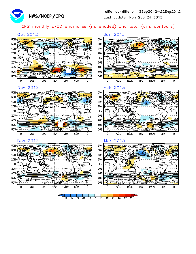
Just for fun, the cold Feb pattern shown by the CFS since last month won't go away ..
That looks nice!
I do feel that we will see a notably cold month this winter and I feel we are likely to see this early in the winter, just as how Spring arrived early, summer arrived very early and Autumn arrived early - I really do feel that by the end of November it will feel positively wintry.
On the other hand we may see January or February being the cold month rather than December so who knows.
The intensity and how prolonged any signifcant cold spell(s) is another matter.
What I would like to see this time round is two very cold months. Preferably, I would like to see a major cold spell starting in early to mid December and lasting towards the New Year, with a mixture of weather following for the half - two thirds of the month before another signifcant cold spell arrives and lasts into February.
The probability of a cold spell among the lines of something between Feb 2009 and Dec 2010 is pretty likely in my opinion. The question is what the winter will be as a whole? Will the remainder be mild; a bit of cold and mild; or cold?
If Anyone who has got stats, fact and historical data could post something about two (or more) sub zero months in one winter; two or more notable - brief or prolonged cold spells and to compare it to below average winters, months etc, the frequency and gaps between winters...
It would be interesting to find out - although the chances of this winter having two major cold spells isn't anywhere near as likely as the one.
-
Maximum snow depths in Angus deeper than Drumochter etc?! Really?
I would imagine that the Drumochter Pass, Strathspey, Southern and Eastern Grampians would get large amount of snow. However, I expect the region of Highland council overall to have smaller snow depths than Eastern Areas due to the Mountains and Geographical Position. If less than a third of that region had snow depths comparable or greater than Angus, you would have take the other two thirds of land into count and the Highland region is a massive area. Anyway, my forecast is just for fun based on my instincts and interpetation of recent weather patterns and factors.
-
A Winter's Tale Long Range Forecast Warning: December 2011
Maximum Snow Depths in December:
Key:
Yellow = 5-10cm
Light Orange = 10-15cm
Dark Orange = 15-20cm
Red = 25-30cm
Dark Redish = 30-40cm
Black = 40cm+
My opinion is very likely to change between now and then however at the moment I feel with the likelyhood of northern blocking to happen after a periods of atlantic lows during the autumn is quite likely.
The map shows northern and eastern areas most likely to be hit by frequent and heavy snow showers. The further south and west you are the less likely to be hit by snow showers.
Although my forecast for January is issued next month, I will have a shot at a brief summery of January and February:
Winter 2011/2012:
DEC 2011:
Well Below Average temperatures and heavy snow at times. Two significant and prolonged cold spells.
JAN 2012:
Slightly Below Average and Below Average for northern and eastern places. Milder to begin with before another significant cold snap arrives. Perhaps some more sharp cold snaps inbetween milder spells later on.
FEB 2012:
Average to slightly below average. A very dry month after a wet and cool January. A relatively significant cold snap during the first third of the month. High Pressure to dominate most of the month. Some significant battleground snowfalls in Scotland to finish the winter.

-
The rain han't been as bad as I first thought (or what the BBC have tried to make it seem).
-
Ive just taken a look at the latest CFS for Temperature
I rest my case with regards to the long range weather models: next week it will probably change.
Can someone explain what that chart is showing (regardless of how pointless and far out it is).
-
Of course you would say that as a scientist, but also as a fellow scientist I know of the limitations of the mathematical and empirical models. Science isnt always correct, in fact because mother nature is not always very good at lending a reliable hand. Howver things in nature tend to oscillate, that we do know, nature loves curves and hates straight lines. Last winter started with a spectacular bang and then fizzled pathetically out the last half of winter (which to all intent and purposes should be the coldest part of winter). Has it not dawned on anyone that whatever turned the winter around on its heals, might not come back and that we are entering more typical weather patterns for our geographical situation, eg wet and windy with the occasional Nly blast. Can you not see a synoptic situation with higher pressure of Mainland Europe and High pressure over Greenland sliding all of the low pressures over the UK this winter. Just as it has been most of this summer. I remember the end of last summer watching a very benign north atlantic pressure map, the same cannot be said this summer.
And NR I am perfectly entitled to my opinion because goodness knows how many times I have heard the same peeps rambling on about solar minimums, gulfstream migrating south and a near neutral ENSO. Im going for a typical winter for the Uk, which is nothing out of the ordinary. Talking of statistics, the odds of a typical winter outweight a return of yet another cold snowy winter, bearing in mind that the cold snap of last winter only lasted 6 weeks (that is for the North), in the South it was just over a month, that hardly constitutes a very cold winter.
A bit of science and a bit of instinct/intuition and observing current and past conditions/patterns is the ticket to having a well balanced forecast.
-
WEATHER DATA FOR PAST DECADE OR SO:
YEAR: 2001 2002 2003 2004 2005 2006 2007 2008 2009 2010
AUTUMN: 10.44 9.80 9.53 9.95 10.38 11.39 9.94 9.12 10.32 8.86
WINTER: 4.53 3.99 4.35 4.71 3.85 5.56 4.86 3.21 1.63 2.43
DIFF: +/- 0 -0.64 -0.27 +0.42 +0.43 +1.10 -1.45 -0.82 +1.20 -1.46
+/- 0 -0.54 +0.36 +0.36 -0.86 +1.71 -0.70 -1.65 -1.58 +0.80
Just some ideas:
Mildest winter followed mildest autumn. Second coldest winter followed coldest autumn.
I guess we need to wait and see.
-
http://www.exactaweather.com/UK_Long_Range_Forecast.html
An update from James Madden.
7th August 2011 Update
Summer 2011 – Recap to date
June 2011
June turned out to be very wet and unsettled across the UK. Rainfall was largely above average, with many areas seeing more than 150% of their normal rainfall amounts, including drought hit eastern areas.
June was also the coldest in the UK for 10 years, with Northern Ireland experiencing their coolest June in 25 years. The mean Central England Temperature (CET) data for June was -0.4C below average.
July 2011
July also turned out to be relatively wet and unsettled across many parts of the UK. Certain parts of England and Scotland received 200% of their normal rainfall amounts, with rainfall amounts elsewhere more near average overall.
July was also the coldest in the UK for over 10 years, with minimum temperature resulting in the coldest July across the UK in over 30 years. The minimum Central England Temperature (CET) data had a significant anomaly of -1.1C. Although it has felt more pleasant at times with less rainless days during July in certain regions, the mean Central England Temperature (CET) data for July was -0.8C below average. Other long range forecasters failed to consider the intensity of the rainfall when it occurred or the minimum temperature, just as they will underestimate the intensity of snowfall and below average temperatures this winter.
Grey Skies
Many regions across the UK have also experienced notable grey skies due to above average cloud cover, as I originally forecast. I expect this trend to continue as I have outlined many times, due to the low levels of solar activity that we have experienced in recent years.
Original Forecast
I originally issued my UK summer forecast on the 30th January this year, well in advance of any other forecaster worldwide.
It read “Summer 2011â€
“It would be adequate to suggest below average temperatures in terms of how I calculate solar activity in my forecasts, so it looks like a summer of grey skies and damp weather, and it's probably safe to say that there will be no BBQ summer again this yearâ€.
I also issued a warning for torrential downpours and severe flooding.
Summer 2011 Publications
I provided the Sunday Sun and Chronicle with my 2011 UK summer forecast in early April which read
“But, sun worshippers have been warned to make the most of the hot weather as long range forecasters say the outlook for summer is gloomy. James Madden said judging by solar activity and the current ocean atmosphere, the UK could see more rain and a dip in temperatures in June, July, and August. He said: “based on the factors covered, the summer as a whole could unfortunately be colder than average with above average rainfall. “In my opinion, odds of a barbecue summer this year are slim.â€
August will have to show a major improvement to avoid a cold and wet UK summer this year. As it stands at present with more unsettled weather in store, a colder than average summer with above average rainfall is looking extremely likely as I originally forecast. The torrential downpours and severe flooding that we have seen in early August, have already seen parts of Yorkshire receive more than one month's rainfall in just 12 hours. Parts of north-east England and Northern Ireland also experienced severe conditions due to localised flooding, with further flood alerts also put in place across Northern England and Scotland.
http://uk.news.yahoo.com/northern-england-put-flood-alert-104014593.html
http://www.guardian.co.uk/uk/2011/aug/04/flash-floods-yorkshire-torrential-rain
La Niña Watch – Update
The Climate Prediction Center recently issued a ENSO alert system status for a (La Niña Watch).
I clearly stated in March and May of this year that
“NOAA predictions give a 50% chance that La Niña conditions will be all but gone by June 2011. I personally feel that this prediction is wrong and once again way underestimated, hence my future flood warnings.â€
“Recent NOAA predictions give a 50% chance that La Niña will have completely disappeared by June 2011. However, I am not convinced that it will completely disappear. Recent indicators may suggest neutral conditions for the season ahead, but it is also important to take forecast accuracy into consideration for this time of year and the current phase of PDO. The possibility of La Niña redeveloping will become clearer over the next few months.â€
Strictly this is true, as atmospheric circulation anomalies still reflect aspects of La Niña. The subsurface oceanic heat content in the upper parts of the equatorial pacific continued to weaken (FIG.1) with strengthening subsurface anomalies in the east-central pacific (FIG.2), hence the La Niña watch that has been issued.
Gulf Stream/North Atlantic Drift
As expected, it is still clearly visible to see from present day NOAA satellite images that no improvements have been offered in regards to the Gulf Stream and North Atlantic drift.
The surface horizontal current (0m in depth) should be more comparable to the image in (FIG.3 – August 2009) below than (FIG.4 – August 2011), in order for the UK and Western Europe to benefit from this valuable heat source.
I clearly stated in early August 2010 that “the strength of the current seemed to be in a position that would no longer feed towards the UK or Northern Europe, due to a breakage that appeared in the gulf loop currentâ€. I have also clearly stated in many of my posts that “if nothing improved soon in regards to the Gulf Stream and North Atlantic drift, that this would begin to alter the climate of the UK, especially more so in winterâ€.
Even at depths of (100m) nothing improves in (FIG.5) below. This is especially important if we compare this to the surface horizontal current of (0m) in 2009 in (FIG.3) below.
Solar Activity
One of the main factors I have strongly emphasised on within my forecasts, is my thesis on future levels of low solar activity.
31st January 2011
Geomagnetic activity is minimal, this will result in extra cloud cover and alter temperatures, with further repercussions of prolonged periods of low solar activity in the future, that could see sunspots vanish.
15th November 2010
The will also have future effects on further periods of prolonged low solar activity.
19th September 2010
This has future effects on further periods of low solar activity, which means more spotless days and more prolonged periods of low solar activity.
Recent scientific research from the National Solar Observatory (NSO), strongly indicate that the next 11 year solar cycle, will be greatly reduced or may not happen at all. Although some sunspots are visible at present (FIG.6), solar activity is minuscule in comparison to what it should be and according to all NASA's predictions to date. I stated in April 2009 that
“David Hathaway is a well respected solar physicist for NASA, who recently reported that there was nothing wrong with the sun on the highly respected NASA website. He stated that the average length of a solar cycle is 131 months with a standard deviation of 14 months. In October 2008 this was 145 months and the standard deviation of 14 months was officially over, which means we are now 6 months (April 2009) outside of his prediction. Although Hathaway suggests that the current solar cycle does not worry him, anticipating many more spotless days before a return to solar max conditions in around 2012? His theories appear very confusing for a scientist who has claimed to of cracked the suns conveyor belt as far back as 1890.â€
Since then NASA and Hathaway have admitted that they were wrong about their predictions in a new scientist article in June 2010. Hathaway also recently stated that we will not reach the 150-200 sunspots as they predicted in 2006, we will instead be heading for a drastic decline that will place us in the lowest sunspot cycle in centuries. As I have stated before this will have future repercussions on further periods of prolonged low solar activity.
The low solar activity that we have experienced in recent years, will once again influence the pattern of the jet stream this winter due to the cooling of the stratosphere. This will block warm air from reaching the UK and create more moisture in terms of snowfall. When high pressure builds towards Greenland (Greenland High) this allows extremely cold easterlies or north-easterlies to develop.
Combined with the other factors that I have covered, this will result in an early start to winter with prolonged periods of cold and widespread heavy snowfall that will see many parts of Scotland/Scottish Highlands, Northern Ireland, North-east England, and Northern England get particularly hard hit throughout. I still expect to see records broken with widespread disruption from snowfall that will once again be hugely underestimated by others.
FIG.6 NASA (7th Aug 2011)
I posted this satellite image back in January 2010 below (FIG.7) and stated that “this is most probably a taste of our near future in the UK.â€
Then this happened in December 2010, only 11 months later (FIG.
I will not be surprised when I can post another satellite image similar to these for the 2011-2012 UK winter.
Our Winter 2011-2012 Publications
Here we have links to what must be the earliest ever publications in regards to an upcoming UK winter below. Maybe this tells us all something?
http://www.strathspey-herald.co.uk/News/No-sun-and-a-severe-weather-warning-21062011.htm
http://www.derryjournal.com/news/local/expert_warns_arctic_winters_on_the_way_1_2826532
http://www.naturalnews.com/033178_radical_weather_extremes.html
http://www.reuters.com/article/2011/06/13/idUS77740+13-Jun-2011+BW20110613
And finally here is some food for thought to leave you all with. The Met Office is to be investigated by MPs following the outcry over the barbecue summer and continuing questions over climate change. The Met office has also come under extreme scrutiny after handing out up to £1.5 million in bonuses, yet they don't issue long range forecasts?
http://www.telegraph.co.uk/earth/earthnews/8648215/MPs-inquiry-into-Met-Office.html
Please feel free to check any of the statements that I have made previously within my past forecasts/blog.
-
Yes Autumn has certainly arrived here with leaves changing colour and a quite a few are on the ground. I'd like to add that the light, air temperature and freshness also feel positively autumnal. At the moment I can only see a few periods of decent weather left this month though the North should continue to be in autumn. However, you can't rule out some decent weather in September.


Mountain Snowfall
in Spring Weather Discussion
Posted
As we approach another autumn, we yet again face the prospects of snowfall on the mountains and hills. Last year, there was a decent snowfall in the Cairngorms and skiing started in November. So this thread is looking at developments of potential or recent snowfalls on the hills. You can post images or update on the situation. Hopefully this will get things a bit more appetising with prospects of snow falling on the hills before we get the real stuff down here. Let's see when the first snowfalls happens, how much, how often it snows, forecasts and of course how high up it snow because the lower the elevation the better!
Estimation for Mountain Snowfall: I'm going for a small snowfall on the Cairngorms in September with a larger and widespread one in October.
First Lying Snowfall: Late October
LINKS:
http://www.snow-forecast.com/resorts/Cairngorm/6day/top
http://www.snow-forecast.com/resorts/Glencoe/6day/top
http://www.snow-forecast.com/resorts/Glenshee/6day/top
http://www.snow-forecast.com/resorts/Nevis-Range/6day/top
http://www.snow-forecast.com/resorts/Lecht/6day/top
http://www.metoffice.gov.uk/loutdoor/mountainsafety/easthighland/easthighland_latest_pressure.html
http://www.metoffice.gov.uk/loutdoor/mountainsafety/westhighland/westhighland_latest_pressure.html
http://www.cairngormmountain.co.uk/webcam