


EML Network
-
Posts
1,210 -
Joined
-
Last visited
Content Type
Forums
Blogs
Gallery
Events
Learn About Weather and Meteorology
Community guides
Posts posted by EML Network
-
-
the drizzle from earlier turned back into sleet/snow again now.
Still have plenty of snow around on the ground, but has become patchy now
-
1 minute ago, mountain shadow said:
Aberdeen under water due to AGW!
lmfao

 thats made me laugh !!
-
 1
1
-
-
12 minutes ago, Tim Bland said:
Here’s Friday morning on 06z in WX format which some may prefer

according to that I now live in Newcastle
-
This is one to watch, Thats a few hours of white out conditions for Lincolnshire and East Anglia.
-
3
-
-
-
Well much better than I had expected.
Snow already beginning to thaw though, so my advice..if you have snow on the ground, go out and enjoy it now as it wont be there for long.
-
6
-
-
Right...time for a walk on the common. a good 5cm here in Epsom

-
5
-
-
11 minutes ago, steveinsussex said:
Saturday is 3 days away though? It may well not happen
its about as accurate as any chart currently and its 12 days older and 48 runs earlier


-
-
Regarding the overnight/tomorrows 'event' we should be able to get an idea of how far North the PPN might go by seeing if it clips the tip of Southern Ireland or not as it starts to encroach around abiut the time the 18z GFS rolls out.
As the projected northward extent never really gets much further North than that
2nd image show this well for midday tomorrow.
-
3
-
-
17 minutes ago, Tim Bland said:
Icon has rain for much of the day (away from high ground) turning to snow in the evening. Chilterns, downs & welsh mountains etc could do well..
Iove how some are ignoring this.
going to be some upset people IMO come this time tomorrow.
Snow falling onto wet ground, with temperatures above zero even overnight and dew points wrong side of marginal.
im expecting rain here if it snows from the outset ill be pleasantly surprized
-
Sleet here now in Epsom/Ashtead border
-
Mets latest offerings.
Mostly rain in the South tomorrow daytime
Snowline for Thursday...Leeds Northwards ?
-
2 minutes ago, sheikhy said:
Bring it on i say!direct hit for me!!!

Gordon Bennet ! thats a 200 mile shift North in 24 hours.
Surely any predictions thereafter will change as a result ?
-
1
-
 1
1
-
-
just plain rain here in Epsom and Ashtead common about 100m above sea level too
-
Its becoming obvious now for those South of London, get out and enjoy whatever snow falls tomorrow before the night because its looking likely to transition to rain as the system heads North.
Amazing just how far North the modelling has moved the PPN compared to what was being modelled just 24 hours ago.
London itself could be in a prime location.
before the real fun heads to the North
-
2
-
-
5 minutes ago, sheikhy said:
Ali maybe those gfs means u posted earlier could prove to be correct!!!wouldnt be surprised if it gets extended even further north!!
if it does its probably bad news for anyone in the South of the warning area = sleet and rain along the coast I would imagine.
Guess we wont have long to wait to find out
-
1
-
-
Just goes to show that you cant really take the snow charts at face value.
im right in the center of that lovely salmon coloured snow zone on the GFS for 6am
The reality...
Yes I know...I forgot to put the washing in
Tomorrows PPN has gone quite a way North on the GFS as well for the South on the 0z run and seems to have been pushed back into the daytime as well. So im figuring that too will be falling as rain.
0Z for 3pm tomorrow
18z for 3pm tomorrow
Thats pretty shocking inconsiatency for something only 36 hours away.
Met office App not even showing any PPN at all for this area tomorrw

Seems little point in posting any other charts now. What does and has throughout this entire saga, seemed more likely is that the area between Midlands and North England are in a good spot for a real pasting and potentially sustained through until the weekend.
Somwhere like Edale Peak Districts and Lakes or North York Moors could do really well out of this
-
7
-
 2
2
-
-
Id think flooding might be making the headlines this weekend if the GFS control is right.
-
2
-
-
Confused dot com !
Dont think many of us are going to wake up tomorrow to much snow if the latest Met Office video is anything to go by.
If anything seems this time tomorrow is more likely to see snow falling out of the sky and falling into wet ground.
= Ice Wed morning and then await to see if we get lucky overnight.
but it will all melt by the time we get to Thursday anyway.
-
3 minutes ago, SLEETY said:
Why no warning out for tues/night we'd morning /snow,
I think they would probably want to wait until tomorrow morning to see if its likely to happen.
Similar to how they waited until this morning to put the overnight warning out.
-
3
-
1
-
-
7 minutes ago, IDO said:
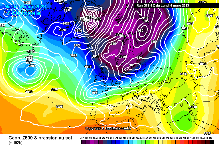
Building blocks for an Easterly setting up there too !
-
7
-
-
-
6
-
-
If I was living in the Lake Districts Id be getting very very excited right about now.
but if you need proof that PPN can crop up at any time during this week.
look no further than right now
GFS PN for 0600
Actual
-
6
-


.png.b1b86ad20a73030ba1dd0af7ecaaa4cf.png)
.png.64ad4a01bd268bffe8cff237af41c318.png)


.png.35499a340affced948e7b997a0b1a06c.png)

.png.23c35f21d2fa2326edcf7b28fe0e6242.png)
.png.087a025c6d8133919aacc17f67d00919.png)


SE, London & EA - Weather Discussion
in SE, London and East Anglia Weather Discussion
Posted
big flakes appearing now in amongst the sleet