


blizzard81
-
Posts
5,277 -
Joined
-
Last visited
-
Days Won
4
Content Type
Forums
Blogs
Gallery
Events
Learn About Weather and Meteorology
Community guides
Posts posted by blizzard81
-
-
2 minutes ago, Eagle Eye said:
How many times do i have to say this. Maybe but it's hard to get a prolonged period of cold even with a major SSW, we're about to get one w/very weak surface response. We just had a reflected wave enhance the Greenland high, w/out we might not even had got it and that was a byproduct of the minor SSW. It was just that we're still in a transient signal period because of the north Pacific signal. A displaced or stretched and zonal link is not a 1 to 1 link, we're not in a zonal set up because of the minor SSW but because of some slight changes in the north American setup combined w/the Alaskan high.
Always North America though. These small changes
-
1 minute ago, Hammy79 said:
Been refraining for commenting on all the moans but this tips me over- pass me the rope? really? A very flippant and not thought out comment at all.
Its weather- it will do what it wants to do, we are literally seeing cold from Sunday evening pour into the UK for at least a week and nothing is set in stone with regard to snow.
Granted we are not seeing the charts we were with a foot of snow in places but in reality that was a scenario in the envelope 7/10 days away. A bit like what we are seeing now with the signaled breakdown- its all scenarios.
Sorry for derailing the thread even more but comments like this get to me, especially with what is going on in the world.
Its. Just. Weather.
He/she could well have been making exactly the same point as you if you think about it.
-
 2
2
-
-
Just now, Bricriu said:
We needed the major ssw. A displaced or stretched pv doesn't cut it as it increases the risk of a return to zonal.
I totally agree
 1 minute ago, Garthvader said:
God almighty pass me the rope!
Give people reasons not to pass it to you

-
5 minutes ago, Lord Grogon said:
“Don’t worry too much about snow chances. Small features will always pop up at short notice that the models won’t yet see”.
I must have read this comment a thousand times in some form over the last few days.
So what has changed? I know people may be a bit grumpy that the models are firming up on an end to this cold spell. But there seems to have been a complete collapse in excitement for the next week. Are people simply overreacting to Wednesdays low no longer going in the desired direction. Or is there something else?
We won't! In response to your first line
 1 minute ago, Wilko999 said:
Snow watch to a bore fest frost watch essentially. Models started to subtly flip a few days ago, some were clinging on but it's normally writing on the wall at that point.
It was when that 'bulge' started to appear wasn't it?

-
4 minutes ago, Met4Cast said:
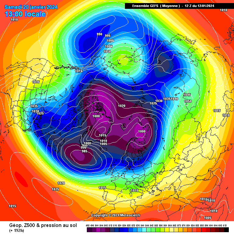
If we look at the GFS strat forecasts I think we can find an answer to where this zonal push within the modelling is coming from.

The Canadian lobe of the sPV appears to get sucked towards Siberia by the stronger SIberian lobe, this occurs 17th-20th, around the time we're seeing modelling flatten the Atlantic pattern out and return the tropical jet northwards. This could perhaps be a response to the minor SSW we've recently seen, perhaps a case of the worst timing ever? (I did muse that a SSW minor or otherwise could potentially disrupt any cold spell a while back).
Once that transition has occurred & based on the current background forcing I see no reason why we wont see high pressure beginning to re-establish itself in a more favourable place for further cold weather outbreaks, Tamara has outlined this far better than I can in a few of her recent posts on this thread.
That was always my biggest fear about this particular warming. I think you're right unfortunately. You couldn't make it up could you?
-
1
-
-
1 minute ago, Metwatch said:
Even the cold that has been stuck around Scandi in recent months is just blown away like it's paper
A while to get there, but more likely than not we are back into a zonalfest for the final 7-10 days of the month. Next opportunity for something of interest is in early February perhaps after next week is over and done with? MJO, rising +AAM anomalies, weakening strat winds etc could come into play, but it's anyone's guess at the moment what will happen in 3 weeks time.I mentioned it yesterday but forgetten by now. I believe the cold air outbreak impacting the lower 48 is indirectly to blame. Temperature gradient increases allowing the jetstream over the Atlantic to strengthen, causing further intense storms over north east USA, overiding any blocking over Greenland, and then sending it all into north west Europe / north east Atlantic.
Absolutely. Predictable now and just a given every winter.
-
6
-
 1
1
-
-
Just now, Richard Fisher said:
I must be the only one that thinks the Wednesday low will reach up to the M4 producing 15-20cm of the white stuff. I just can't see it staying in France based on the Mets low probability of this.
24 hours behind the curve. Not for the first time and not the last.
-
3
-
-
Just now, damianslaw said:
Keep an open mind model wise beyond 120 hrs.. whilst the models are keen to bulldoze the atlantic through, we have a distressed PV - and I would not be at all surprised to see height rises to our NE begin to show in model runs next week for late Jan as the PV continues to stretch and weaken, early next week may see it perform a last gasp so to speak, but it is clearly on the ropes.
Tell the EC46 this.
-
1 minute ago, tight isobar said:
The mother lobe truly regaining her throne!! Not a good Synoptic at all for immediate/ mid range cold for the uk thereafter.!
Amazing turnaround.
-
1
-
-
Just now, IanT said:
…but 11 days away!
All the models are converging on this now though.
-
1
-
-
2 minutes ago, Bricriu said:
I wonder is it a response in the uptick of zonal winds?
Good point. It certainly coincides with this.
-
1 minute ago, IDO said:
It is beginning to play out now. Next Friday, the pattern has collapsed, and on Sat/Sun, we lose the cold uppers and enter a westerly regime for around 7-8 days on current GEM and GEFS means. That westerly flow has yet to be qualified: zonal, cold zonal, or N/S. That remains the question for the latter third of Jan.
As for further cold interest, the models only go to the 28th, so who knows? But looking at the setup, with blocking East to West over the polar field (Pacific and Siberian mean highs), we do need some of these background signals to kick in and not have the three-week changeable spell we had after the Nov cold.
The 12z GEFS mean similar to the 0z from D8-16:
Maybe UK N/S split as to wind and rain?
As for next week, it is cold down in the south and probably the best is a few flakes locally for the minority. Scotland should get a good fix. The low from the Azores looks like a miss, but I will give it one more day to edge north before writing it off.
Your post could just be summed up as 'law of sod' unfortunately.
-
1
-
-
Just now, Hammy79 said:
Is it possible its working on the data the the ops are running with at the moment( where we are seeing a flip back to milder conditions) and not seeing the background signals?
So many questions aren't there? How could there be such a complete 180 degree flip? Especially as it goes against those background signals.
2 minutes ago, January Snowstorm said:I see some of the regulars have vanished tonight! It's kind of surreal to think we woke every night at 4am to eventually end up with this for dinner. It's more of the same really next week cold or very cold but dry. Must be the longest chase in NW history with little to show for it. We didn't even get frost this week just unpleasantly cold..
I didn't.... 4am I mean
-
1
-
-
Just now, Sweatyman said:
absolutely useless. by the time we get there it'll be March next
Try April
-
1
-
3
-
-
- Popular Post
- Popular Post
5 minutes ago, blizzard81 said:Ec46 now pushing any cold interest back until the middle of Feb, after next week.
I find it quite astonishing that within the space of one week we see the complete inverse in synoptics. It's unreal. Talk about polar opposites, if you excuse the pun.

-
10
-
1
-
 1
1
-
Just now, tight isobar said:
Every chance atm..
Optimistic.
-
Ec46 now pushing any cold interest back until the middle of Feb, after next week.
-
1
-
1
-
1
-
-
This spell feels like a more cruel version of the end of Nov/early Dec cold snap. Brilliant synoptics but yet again, most lose out on what really matters. I say this even though I was one of the very lucky few who saw 3 separate snow episodes back then. However, I always remained very conscious of the fact that the vast majority didn't see diddly squat. It is also like the early December cold spell of 2022. It's like the white stuff is like gold dust even though synoptic wise, the charts would give the old classics a run for their money. It really is crazy.
-
5
-
1
-
-
1 minute ago, Sweatyman said:
course it does! typical really
It's hard not to laugh isn't it?
Either that or cry lol.
-
1
-
-
Just now, Bricriu said:
You can nine times out of 10 believe post t120 if it showing a return mild especially when that is backed up broadly by the ensembles. I don't care how unique the set up is. We are very unlikely to see a switch to extending the cold now. It's just a question of how long the milder turn lasts
We just have to keep hoping that the ukmo is nailing this better than the other models but it is beginning to look increasingly isolated now.
-
1
-
-
That huge intense pv lobe heading off the eastern seaboard is just looking irresistible now at the end of next week. These US pv lobe bombs seem to happen every year now and it is these that scupper any chance of a meaningful and lasting cold spell in the UK.
-
3
-
-
2 minutes ago, sheikhy said:
Well if the models are anything to go by ths evening then a lot of us are gona be wondering after all that effort on here what the heck the hype was all about!!nothing widespread in terms of snow and also milder weather moving in by end of next week!!!sure surprises shall turn up in a few spots though or maybe not!!!
Must admit, it does look rather lame in terms of snow plus the models now seem hell bent on the tpv taking a large dose of steroids in a week's time from now.
-
2
-
1
-
-
Absolute brutal cold surging into the US - Again!
-
Another good ukmo run to follow up it's morning run.
-
6
-


.gif.ee211c43ea156d140040fd5ff2107613.gif)
Model Output Discussion - Colder but how cold and for how long?
in Forecast Model Discussion
Posted
Just Googled Dan Hutchings weather....... Drew a blank. Feel like I've been played


 . Joking aside, not good trends today at all it has to be said with regards to something more than a 5 day flirt with winter.