


Bottled Snow
-
Posts
166 -
Joined
-
Last visited
Content Type
Forums
Blogs
Gallery
Events
Learn About Weather and Meteorology
Community guides
Posts posted by Bottled Snow
-
-
7 hours ago, Rocheydub said:
And a great set of runs this morning, UKMO back on board! GFS goes off on a bender in FI bringing SWl’ya back in, but this very much goes against all it previous runs enem in GEFS. No concerns at all.. Big ECM coming up now!
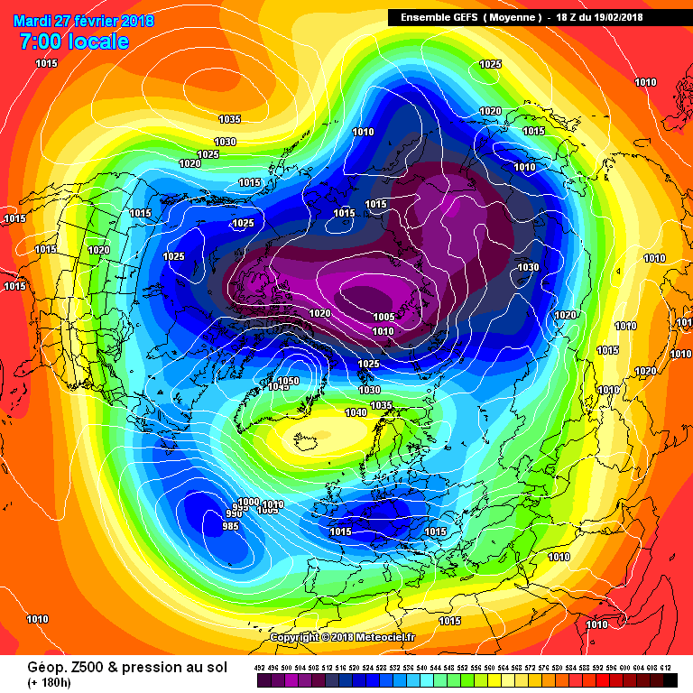
Yes I was worried yesterday that HP would stay too close to our north resulting in cold but mainly dry conditions. However the clear trend for last few runs is to see Ireland hit by a direct easterly with very low uppers, thicknesses and dew points. The Irish Sea should act as a snowmaker once the deep cold gets in early next week. Also risk of more organised snow pushing up from the south later. If current charts verify this could be a spell to rival some of the most potent in the last 30 to 40 years. Amazing considering we are almost in March. Areas most prone to snow would be eastern counties initially but risk likely to become more widespread once cold gets entrenched. As ever always the risk models are over egging things but you get the feeling that all the pices of the jigsaw are coming together now for a memorable event. Exciting times....
PS temp only 5.5 degrees here today in cloudy skies and very brisk southeast wind. The continental feed is already starting to take effect.
-
5 minutes ago, edo said:
thank you @Bring Back1962-63an outstanding well put together very readable post for even a novice
here here ...excellent analysis as always by @Bring Back1962-63
-
 2
2
-
-
20 minutes ago, Man With Beard said:
Clusters finally out but what's this! The numbers do not add up to 51!! Have ECM censored some of them for being too cold? Or too mild???
Anyway this is what we have at T168

3 insanely cold clusters and 1 cluster (the one with 9 runs) that sees the cold pool hitting the southeast but high pressure dominated for the NW. So the "spoiler" cluster of the morning isn't repeated on the clusters we can see tonight. But what of the missing clusters...
EDIT: Just seen that the T156 is complete:
And you can see that the missing cluster is the most ridge dominated for the UK, similar to cluster 2 this morning. But only 8 members in it - the numbers considerably less than this morning's similar cluster. The trend is towards a direct hit from the cold pool, not away from it.
Excellent post and very encouraging to hear. Based on your summary and on GEFS also going for a more direct hit, albeit rather shortwave crazy, we should see UKMO revert back to snowier charts tomorrow, versus the more southerly based high pressure and drier scenario on current run.
-
1 hour ago, Neiller22 said:
Bonkers 18z snow fest! Likely hood of happening. Zilch!
GEFS certainly messy with all those shortwaves. The positive for me though is that the majority of GEFS ensembles have a direct hit of cold uppers and therefore higher snow risk. Very consistent with this so hopefully the UKMO will revert to high pushing further north in future runs, as currently it shows cold but dry with high pressure too close. ECM mean very good this evening but again a little nudge north of the high on ECM would see the coldest air with low thickness levels hitting Ireland and with it better snow prospects. Hopefully the models converge on this in future runs to give us a spell to remember.
-
50 minutes ago, Aliaalu said:
Can someone please summarise chart outputs today. It was my mothers birthday and I had her and her fellow widow chum out for day to Newcastle, exhausted! Who would have thought a day trip with 70-80 year old so exhausting! I have no energy left to read Model thread.....
You would need 12 cans of red bull at least to even think about it?. All models agree progressively colder and dry until Monday. Bitterly cold thereafter with snow risk increasing..... obviously models differ at that range but general theme is for cold to last through next week with possible troughs in the flow bringing snow to some..Frost and ice also widespread.....As we get closer to Monday we will have better idea regarding snow distribution but as always, east is best in these situations.
-
12 minutes ago, Allseasons-si said:
Oh get lost!
this is taking the mick now,means at 180,240
we could be looking at a memorable winter 2018 here matching the historical events of 1947,63,81,87 and 91
and i am getting quiet worried.
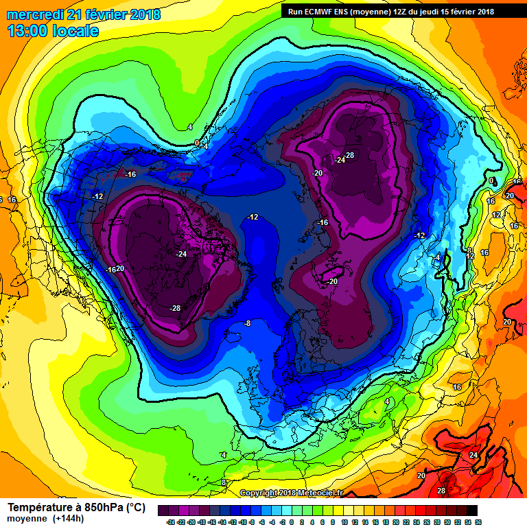
Two brilliant mean charts....the 240hr is exceptional as although the high retrogresses to Greenland we are still in a flow east of north with continued injection of cold uppers ..... continuing risk of more widespread snow in this scenario versus a straight northerly .....we couldn't ask for any better really.
-
6
-
-
Latest 120 hour fax chart for noon Saturday.....Scandi high flexing its muscles....strengthening easterly wind.....bitter cold spreading westwards over Europe.....destination British Isles.....Its coming
-
4
-
-
On 14/02/2018 at 22:23, The Weather Watcher said:
easterly looks more and more likely each passing day.....winters last hurrah could be a stunning one this year.....hopefully kicking off next weekend
-
1 minute ago, Chris D said:
Best chart of any.
Yes my interest / excitement only really gathers pace when cold spells come in to range of Fax charts which are generated with professional met input....excited now...
-
1
-
-
Latest 120 hour fax chart.....notice the warm front in Atlantic west of Ireland facing / heading northwest towards Iceland rather than the normal push eastwards....sure sign of retrogession of cold block...UK and Ireland already in easterly flow ....awaiting infux of very cold uppers and snow from east....stunning output.......night all...
-
4
-
 2
2
-
-
2 hours ago, Banbury said:
Very good
No quick route to mild from there. Ties in with Met forecasting that this could be a prolonged cold spell
-
5 minutes ago, bradythemole said:
I know it has felt that like all winter. But not true in this case, this is very different.
Now down to Day 8 on ECM op and the building blocks are in place before this!
Yes we are under an easterly influence a few days from now. It is only a matter of how long it takes the really cold uppers to reach our shores. Looking at this mornings charts, days 7 to 8 seems a good call but temperatures are slowly droping each day from midweek onwards as the high is already in place. However don't be surprised to see it turn colder a day or two earlier as this is a very rare event and I feel models may still be underestimating the full potential of this record breaking SSW
-
3
-
-
1 minute ago, Lampostwatcher said:
them 3 you mention 78/79 , 81 , 87
is the reason us 40 + year olds have been hooked on the white stuff for years
1987 is the still the champ of all easterlies in my opinion and left a lasting impression. The charts currently being modelled are as close to those synoptics as one could wish to see...Still a way to go before we can get too excited, but if ever we had a chance of seeing something similar to that event, albeit late in the season, then this is surely it.....The latest fax chart I posted above is positive in that regard, as the building blocks are clearly being laid in a relatively reliable timeframe, and with met forecasters input ....exciting times for sure
-
2
-
-
Latest 120 hour fax chart....scandi high in place ......turning colder at the surface in freshening east wind...it seems this predicted very cold spell is starting to take shape
-
4
-
2
-
-
11 minutes ago, colonelks said:
Oh and I think its written in the stars... I was on a train back from Derby last night and happily browsing the forum when I looked left and noticed the chap next to me doing the same, what are the chances of 2 weather geeks sitting next to each other on the same random train? We had a little laugh and chat about how this is all going tits up and then boom I check the ECM on my next train and we're back in the game.
alright hands up peeps.....
which one of you was on the train with colonelks ??
-
3
-
-
not a bad 120hr fax chart... .....
-
13 minutes ago, SN0W SN0W SN0W said:
Solid mean at 144
The uppers on these mean charts are colder than on the operational run. Good....
The mild runs in mean chart will skew the mean. So if the colder cluster is correct ,expect uppers to be lower again in reality than the mean currently shows........Very good
Icon is the new God of models......Excellent
-
2
-
-
4 minutes ago, karlos1983 said:
Well, when your bottom line (££$$) is all that really matters, decisions have to be taken above the level of forecasters, call it a strategy if you like. So although it's probably the more favoured outcome hence why they've weighed towards it, I still think there is an element of punting going on! Way to much detail in their forecast so far ahead, when usually they caveat all the long range forecasts historically.
Call me a cynic if you like, it's just my take on it.
Fair enough everyone is entitled to their opinion. I just would not see them making a forecast for the reasons you outlined. Yes every forecast is a punt as such but based on the best information to hand. In 2012 they were very much on the fence whether it would turn very cold or remain very mild. As it turned out the cold and snow reached the east while the west was mild. This time they are much more bullish and state that it 'May' turn milder at times in the west so a higher liklihood that cold will win out this time in my opinion....all will be revealed in due couse ....
-
1
-
-
20 minutes ago, karlos1983 said:
Either way, it's quite a ridiculous update if you ask me! No model agreement at +96 never mind later next week. Far to bullish and they could come out with egg on their faces! Perhaps it's a punt that they hope will come off given they've just lost a huge contract, then they can shout from the roof tops that they said it first. Probably worth the risk in the grand scheme of things!
Ha Ha I doubt very much that the UK MET would take a punt on a forecast they hope will come off so they can say they said it first. They are a professional organisation with access to much more data than we have. They are calling it cold because that is what the information they have to hand is pointing towards. If it was pointing to mild they would changed their forecast......
-
Just now, The Eagle said:
ECM has moved slightly to the UKMO at 72 to 96 hours which is very positive.
and in general and from experience watching models, once UKMO flips at short range to a colder scenario it usually ends up correct......2013 and WTF springs to mind....
-
3
-
-
3 minutes ago, Jimmyh said:
So where did i see that the ENS were showing today that at some stage during the day the mild option was the scatter where everything else was showing cold
Yes earlier runs showed majority of members going the cold route whereas 18z shows cold runs slightly in minority. Let's sleep tight and hope for upgrades over next few days....
-
16 minutes ago, tight isobar said:
!.
Thats quite a drastic- uptick in ens tbh.
I certainly was't expecting that!.
The mean been heavy on the mid solution..now upspikes and takes members in toe!!!.
Not a good sign!!!
Yet could be the overide- and note b4 agree come into, situ...and the band starts playing again....'perhaps' !!???
I counted 8 brilliant runs for cold from mid term to day 16. Another few eventually get there right at the end. However there are now marginally less very cold members in this suite compared to last few days. Still a strong enough signal and maybe a rogue set, but worrying all the same. We need to see tomorrow's suites show more cold runs to raise confidence. It would also be good to see the operationals come on board with the colder solutions
Night all....
-
1
-
-
29 minutes ago, Mucka said:
Taking a step back and looking at the last few days of output from ECM and GFS in an attempt to separate reality from expectation and perception.
ECM
ECM has only shown cold upper air getting across the UK from the East in 1 of its last 8 runs. (12.5%)
GFS 00z and 12z only out to day 10
GFS has shown cold upper air getting across the UK from the East in 4 of its last 8 runs. (50%)
ECM and GFS ensembles
Both favour colder weather from around 21st/22nd but both have wide range of solutions and scatter with milder runs.
If we look at the lesser models then they are more optimistic about cold chances within the next 10 days.
It is impossible to come to any definitive conclusion except that there will be proclivity toward a more blocked pattern from around the 18th.
There is a low probability of cold pattern establishing itself from around the 20th
There is a little better than average probability of cold pattern establishing itself sometime last 3rd of Feb but lower probability that will be before last week of Feb.
All of the above based on current and recent output.
Things could look very different with new information.
Great post Mucka which highlights the uncertainty especially with this ongoing SSW event .
These easterlies from experience even when they do get here are usually long drawn out affairs. As far back as 1996 I recall forecasters and newspapers here were predicting cold easterlies and a white Xmas about 4 to 5 days out. They eventually landed New Years Eve and gave us a white New Year
Even in 2010 models had initially predicted the really cold uppers to arrive seceral days earlier than reality.
However all the the signs, including anomoly charts and ensembles are to me showing a strong emough signal to believe we will eventually see a very cold spell arrive hopefully mid to late next week.
Fascinating to watch it all unfold though...looking forward to tomorrows runs already...
-
1
-
-
44 minutes ago, The Weather Watcher said:
I'm inclined to say the benign sort of spell seems more likely, but things are still not clear and probably won't be until the latter stages of this week as to whether the SSW is going to impact our weather or any HLB easily being shifted by a quick movement/rebuilt of the PV over Greenland.
you could be right however I do believe that a cold or very cold spell will arrive via northern blocking but it could take until late next week to materialise. The latest anomoly charts which are normally a very good indicator are very strong in signal for this, versus the often flip flopping operational model runs. How long lasting is up for grabs but potentially cold at least in to early part of March and maybe longer would be my call. However all the pieces need to fall right and certainly no gurantee that will happen....fascinating to watch it all unfold though....this SSW is going to play havoc with models for some time yet ...


Ireland Regional Weather Discussion 16/01/2018 Onwards
in Regional
Posted · Edited by Bottled Snow
Yes the east and southeast in the firing line However I expect showers to push across the country at times in the strong easterly wind. So anywhere could see snow by midweek. Excited now....Been waiting years to see a true beast hit our shores again and this looks almost on a par with the 1987 beasterly. That buried much of the eastern half of Ireland in feet of snow. Living in the southeast, I was lucky enough to experience its full force. The snow showers were so frequent that even as the sky cleared as one shower passed through there were snow flakes tumbling down as the next shower followed on its heels. This lasted for 3 days followed by 2 dry cloudy days before mild southerlies took over. That was the only disappointing thing about the 1987 spell that unlike Jan 1982 or Dec 2010, a freeze never followed the snow and it soon turned milder with rain. Would love to see a Jan 87 repeat next week but with an extended cold period thereafter. I kept records of Jan 87 and have studied charts ever since. I honestly believe the synoptics next week will run that spell close for severity, irrespective that we are later in the season. exciting times and hopefully everyone gets in on the action.. and all that before a possible frontal snow event later next week....