


Gavin Hannah
-
Posts
1,317 -
Joined
-
Last visited
-
Days Won
1
Content Type
Forums
Blogs
Gallery
Events
Learn About Weather and Meteorology
Community guides
Posts posted by Gavin Hannah
-
-
The strength of the El Nino is impressive to look at. And the eastern seaboard looks like it could be nice for a dip with those temps lol.
-
Found this comment from Thomas Shafernaker - http://www.techtimes.com/articles/84723/20150915/strong-el-ni%C3%B1o-could-bring-another-big-freeze-winter-to-the-u-k.htm - which no doubt some of the press have subsequently put 2+2=5 - deciding that just because el nino might have helped intensity the winter of 2009/10 (i.e. by increasing moisture levels in the atmosphere) - then every el nino must obviously mean a repeat of 1962 etc - despite the fact that atlantic sea temps and other factors have a greater bearing on what matters here - i.e. northern blocking. Poor journalism - but that's symptomatic of almost everything output by the MSM these days - IMHO anyway.
"This time round El Niño could be the strongest in decades," says Met Office meteorologist Thomas Shafernaker.
"In Europe sometimes winters end up much colder and drier and last much into spring" with a strong El Niño, he explains. "In 2010, the El Niño played a part in bringing huge amounts of snow to the U.K."
That's what annoys me about damn tabloids. They always take stuff out of context. Just because something is 'possibly associated' with contributing to condition x, doesn't mean it will automatically happen. That said, would love another smowmageddon!
-
 3
3
-
-
Incase you haven't seen the Mail.
They have some pretty pictures as well.
And there is a bit about a Tornado in Northhampton yesterday.
-
Putting this into seasonal thread, Jamstec's September update is up and very pleasant on eye,with below average temperatures for UK and Ireland and above average precipitation for south, drier in north,north west
Precipitation Dec,Jan,Feb
Ooooooo that is eye candy indeed. Almost like a noreasterly making it's camp over the UK.

-
1
-
-
Can't be any worse than last year. We had one snowfall which settled for a round 3 hours and then it melted and was warm in the afternoon. Such a shameful winter.
Let's all hope we can do much better this winter. And El Nino might be a help, like it was in 2010.
Fingers crossed!!
Here's hoping!! A 2010 winter would be very nice indeed. Or and 09. IT's been 4 years of ramping and moaning about our cursed luck in here the last few years. All those nearly scenarios that failed to materialise.
-
4
-
-
More like a typical winter's day today rather than autumn down south. 15C, windy with heavy showers. Usual Christmas day weather
Had loads of apples this year, all but one were maggot infested, as for the squirrels, they raided my nuts extra early this year. Looks like high pressure could move in for October. Those darn pesky varmints!! Lol. Looks like HP for the weekend coming. Just transitional or something more permanent as you say?
-
1
-
-
I can say down here that the berries have been in abundance this season. The brambles in particular have been impressive. Trees though are finally starting to turn. A proper autumn week this week too.
-
Coldest winter in 50 years due to El Nino. https://uk.news.yahoo.com/britain-may-face-coldest-winter-064022054.html#1x9vVBK
Meteorologists have predicted that Britain will face its worst winter in over 50 years as a result of El Niño.From the same article above:
-
1
-
-
Aaaannnd I'm back! Wow, looks like the north west passage was almost completely open this year.
-
The GFS output almost reminds me of the great let down a couple of winters ago where at around t.48, the promised N'easterly that looked set to bring severe cold and snow simply vanished.... The last few runs on the GFS models are heartbreaking. Even the Xmas cold shot has been downgraded while the period after is looking stormy and very wet.
I know the past weeks output has been very promising, but this isn't the first time I've seen this happen, nor do I expect it to be the last. :smiliz46:
-
1
-
-
Wow, in 24 hours it's all gone all pete tong on the charts for the Xmas to New year Period...... Where did I put those anti-depresants??
-
My bad Ronan lol, Probably gona give it 55%.
-
Well the 12Z just rocked! The Greenland ridging is just not getting a chance to dig in so this will be an interesting period of model evolution for ther period between Xmas day and New year.
My esitmate for low level snow on Xmas day.. Scotland 60%, England 50%, Wales 50%
Crucial E tonight. Really need to see a cleaner evolution on the Greenland ridge and no pesky short waves
Those shortwaves developing off the north coast bringing lots of snowy goodness from boxing day onwards.
-
2
-
-
I think this describes most of us in here when chasing after that fabled Acorn. Or snow in our case lol.
-
3
-
-
Going to lock this one in the next 30 minutes and open a fresh thread in time for the 12z's.
Fair enough. 17 days into Dec and we're already at 129 pages lol.
-
2
-
-
Computer says yes.
That looks a bit conservative if you ask me...
-
http://www.mirror.co.uk/news/uk-news/uk-weather-country-set-worst-4797980 ...........
I know it's the wrong thread but since fergieweather mentiond Exacta....hehe. -
The output is pretty consistent upto the weekend. It's the finer details that will get nailed down for Xmas day itself this weekend. All, in all, it's still looking "Very promising" for Xmas day, boxing day and perhpas Xmas eve for some.
We need to look to the Eastern Seaboard off Canada this weekend. What happens here is going to determine what kind of cold snap this will be, be it fleeting, sustatined or epic builder.
-
1
-
-
Post Xmas on the GFS P is an absolute stonker! It is rapidly becoming my new favourite model. The key difference to the 18Z is that the ridging is extends further east which puts the uk right in the firing line rather for heavy snowfall rather than just missing out.
00Z
18Z
The presence of a few shortwaves off the north west coast also aid in setting us up for some really fantastic FI charts if cold and snow is your thing.
-
6
-
-
Everyone ready for the 00Z runs?? Good, see you all in here tomorrow when we start this all over again lol.
-
9
-
-
Well thats another run with some decent looking winter weather (Temperature wise). A slight variation on the 12Z upto around t.126-ish. So, I would have to say, atm, unless something drastic happens, Xmas looks like being cold for most at least. Snow fall on the other hand, well that depends on how the pattern evolves over the next few days as we edge towards the weekend.
Woah....
-
7
-
-
Massive whodunnit on tonight's MOD thread
Mystery surrounds
1. Have knocker and mushy hacked MattHugos Twitter account and planted 51 eps ens?
2. Has a west based -NAO caused Nick Sussex to throw a wobbler
3. Who or what is a mean....confusion reigns today
4. Recretos disappearance causes consternation in the Strat thread!
5. Pattern change to be or not to be that is the question?
6. Will Glacier Point please return!?
7. Short waves not causing consternation but due to return at T48
8. MOD thread explodes when Ian Brown posts a Greenland High of 1080 but claims a south westerly mild flow
9. Everyone starts agreeing on MOD thread and it becomes a bit boring!
10. Everyone is happy when snow falls everywhere in the UK on Xmas day
Lol....
-
Rumour has it pub run is a belter and will cause many a sleepless nights upon members.
Lol, if this is true, this site will go into melt down!
-
1
-
-
MattHugo81
Incredibly all 51 EC ENS members between 24th - 26th Dec develop low pressure to the NW with a mild SW'ly and not a hint of cold weather!
ECM is notorious for op led ensemble bias. It tends to do this when there is uncertainty in the system. I would wait for at least two more runs before I took it at face value (two as it usually backs down in instalments).
Yup, even with the GFS, a few more runs are needed. Though that could be why the METO updated the outlook to mild today. Time to strap in for the pub run tonight and see what we get.
From the banter thread...
Rumour has it pub run is a belter and will cause many a sleepless nights upon members.
-
1
-


 Had loads of apples this year, all but one were maggot infested, as for the squirrels, they raided my nuts extra early this year.
  Looks like high pressure could move in for October.


 I know it's the wrong thread but since fergieweather mentiond Exacta....hehe.


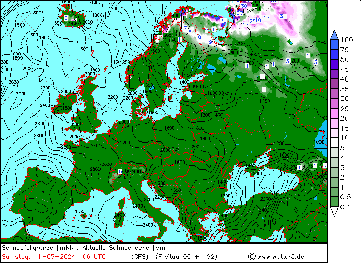
Model Output discussion 1st September 00z------->
in Forecast Model Discussion
Posted
I think many of us have been burned too many times by the Jet to take 'odds - on' trends at face value. It seems we need to load the dice in our favour to get those magical moments to fall just right. Ideally, we want the sort of HP setup in image two to take hold late december.