


tight isobar
-
Posts
5,411 -
Joined
-
Last visited
-
Days Won
15
Content Type
Forums
Blogs
Gallery
Events
Learn About Weather and Meteorology
Community guides
Posts posted by tight isobar
-
-
2 minutes ago, PiscesStar said:
What are your thoughts as things stand on the models
Anyones guess atm- I’ll reiterate, today’s outs will almost certainly firm up now. Kent has a decent chance of some snow for sure even given the current outs.. we’ll see where we are at this afternoon
 . @ outputs latest takes.
-
 5
5
-
-
-
- Popular Post
- Popular Post
3 minutes ago, Gowon said:A bit more ppn getting further south now on the ICON:

Encouraging. As I said (but post now moved) it’s the 1st official day of our arctic outbreak, and I’ve already had an unexpected dusting!.. on we roll the gfs 6z will be interesting for possible upgrades in placements.
-
10
-
Incidentally - this being a notion of unexpected activity, only a dusting but not picked up via any asserted model!!! @ Bampton oxfordshire just now .

-
3
-
 1
1
-
 1
1
-
-
25 minutes ago, nick sussex said:
There’s still some uncertainty there , also as the front might pivot as the low tracks east so some precip could edge nw into the far se as that happens .
It is very frustrating as the snow could have lasted a while .
I’d give it till the end of today .
We are rinsing the hell out of this now !!

 .. but yeah 1 more pop it’s I suppose worth but for me no change via the 6z. It’s a dead en. But again we’ll give it a final note this morning…
-
2
-
-
Bummer
 .. still not completely shutting this 1 down just yet.. this is the crux of northward transfer!!.. I’ll still await ens.. nxt suites I think…@north west waver spoiler -
-
5
-
-
-
6
-
-
Just now, JimBob said:
Met office warning now out until Thursday and none for the south so they see no risk of snow down here.
These warnings will wax n wane over the nxt few days- as to be expected in such a flow- tiny increments will change possible warning
 zones/ areas. Seen this MANY times ..
-
4
-
-
8 minutes ago, Ali1977 said:
The last METO didn’t mention it, so I’m hoping that’s because it’s changing all the time. We need a big move north on the 12z - v unlikely but certainly possible!!
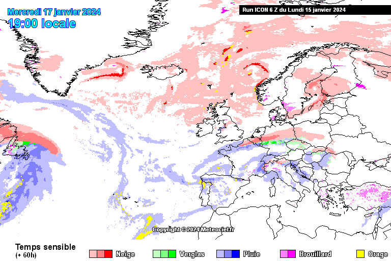
The 00z London ones say… precipitation “highly likely “ between 16/18th on we roll…. To add gfs 6z snow depth chart for the same time “ given it’s all subjective atm” but rays of light certainly filtering through on this ..
-
6
-
-
Yeah ere we go again peeps-( buckle up buttercups) msts 00z even hinting “ bk end of January “ cold transition!! . And can we perhaps get a better wellied mlb/- HLB together . Further I’m still punting some drops n shocks, in our now getting - going cold SPELL!- even though the very latest modeling discounts that to a degree.
-
3
-
-
1 minute ago, Ali1977 said:
Strong mean for the south still
Now that a solid mean!! Over to the 12z on this 1
-
5
-
-
We are now over the cusp and into arctic airflow.. and that being on the very verge of a new week- That all taken into account today’s 12z suites would/ should offer up much sterner exaction’s!.. on local overheads- as well as nationwide!..
-
2
-
-
1 minute ago, Kasim Awan said:
Yeah looking like going to the South now. Around a 15/20% chance of a more northerly track.
Even the risk of snow showers into the Cheshire gap has reduced somewhat.
The fact is over 90% of the UK population will remain snow free from this cold snap.
The risk of troughs forming in the flow is very low because it gets shunted out by Atlantic air very quickly.
Enjoy everyone

Indeed snow chances evaporating every run
 now !!!@countrywide.
-
3 minutes ago, Ali1977 said:
Well I think that’s it With the ECM and UKMO not showing it , it was always v unlikely!!
If there’s no change on today’s 12z it’s a no - goer!!. Kent and the south coast still in with a pretty big shout.
-
3
-
1
-
-
I’m dropping v1- snap going forward- from tonight’s 12z epsf- The next variation is there and … let’s hope it’s an evolutionary trait, @ eyes to the polar CONTINENTAL plots….

-
4
-
-
Just b4? I rip through the eps throws like a hungry man going through a bin!!! Let’s take a blend of upper temperatures/ member trends- and precipitation!!! I’ll leave the longer term s said “ for now”!! Let’s look at a random blend of icon/ gfs/gem- keeping it simple the guise of pressure- and precipitation spikes with a flat 24 hr zone in ens @cross ,,, more or less… these the London. Spreads.. precipitation- to level values say…. The ops/ raws are underestimating the frontal interruption “ pretty naively”!!! - watch this 1 upgrade in a massive/marked scale….

-
6
-
1
-
-
2 minutes ago, Tim Bland said:
Here’s another view of icon for midweek. Gets above m4 in the east and covers London and Essex up to beds and just scraping south cambs ..
The prognosis is …

-
5
-
1
-
-
4 minutes ago, Mcconnor8 said:
This run also has snow in the midlands as the low moves away.
That’s a watcher!- I had a feeling not only an inland extension.. but a bow..n, pivot under the flow….. That “would be something “!!

-
5
-
-
5 minutes ago, Ali1977 said:
Nearly up to the M4

Safice to say- a classic under /upper maybe?!! The energy it will have gained… if she hits @ 150/200 miles on bedrock!! It’s snow chaos!! “ once again “ - this is a truly evolutionary if- but- or maybe.. keep watching

-
8
-
-
41 minutes ago, Ali1977 said:
ECM no where near though unfortunately
We have until Monday on this- and I’ve seen these bounce until 12hrs out @ fruition! It’s still worth a note..
-
7
-
-
- Popular Post
- Popular Post
Ec 96- northward she rolls !!
-
14
-
 northward track on this - how effective still remains!!
-
3
-
-
4 minutes ago, Tim Bland said:
Good for the south East on Weds. let’s hope the northward push continues so more of snow starved south can get at least a covering out of this spell

There is scope !! And if the-gfs has relaxing shortwaving in the mid Atlantic north.. the window becomes wider!!
-
Ec 6z- and a want of uk channel/ land mark structure!!.. again this has legs..
!! Nudge north ya @@******
-
6
-


Model Output Discussion - Colder but how cold and for how long?
in Forecast Model Discussion
Posted · Edited by tight isobar
A definitive sway into southerly tracking winds across france… and biscay she’s getting bumped up ???


