


tight isobar
-
Posts
5,411 -
Joined
-
Last visited
-
Days Won
15
Content Type
Forums
Blogs
Gallery
Events
Learn About Weather and Meteorology
Community guides
Posts posted by tight isobar
-
-
Incidentally a much better shape n, angle of attack via lps on gfs 6z let’s ava look what she does !!

-
 5
5
-
 1
1
-
-
- Popular Post
- Popular Post
Just a quick illustration of how slight variations in wind components / direction can have a massive effect on precipitation on our small island… all that lovely white stuff going begging!.. however also an illustration of how we could well see some surprises nxt week


-
13
-
1
-
- Popular Post
- Popular Post
As a southern contingent member, I feel as though I had an invite to the wedding of the year!- only to find out the groom is now banged up- the bride is missing n, they both now hate each other
 .. yet as a substitute the local drunk has he’s 40th in the local spit n sawdust boozer on the same day!
 .. a bit deflated for sure!! But on a serious note there still remains big scope/ hope for the northern contingent, and still outside chances further south- as pop up occlusions and / or developing shower activity in the flow materialize… what’s more im of high confidence that the Atlantic bash through may not survive to very long… av a good day no matter what your preference/ persuasion

-
26
-
Just now, blizzard81 said:
Amazing turnaround.
Indeed !!!!
-
1
-
-
The mother lobe truly regaining her throne!! Not a good Synoptic at all for immediate/ mid range cold for the uk thereafter.!
-
2
-
1
-
-
1 minute ago, Scandinavian High. said:
Is there any chance this system could move north to effect southern England.or As the dust settled now on this.
Every chance atm..
-
3
-
-
Intriguing evo… the 18z trying to perhaps make something out of mass pv lobe energy’s!
-
1
-
-
Definitely wont land making @ southern most uk…@Lps gfs 18z still has wiggle room though this.. it’s 5/6 days out..
-
6 minutes ago, Sweatyman said:
why does it stop there and not carry on?
It’s an occlusion, so Peters out rather quickly.
-
1
-
1
-
-
Output Out to120 hrs.. then it’s dynamical no man’s land - there is an awful lot to be balanced out from after Thursday nxt week!!
-
4
-
-
It’s not yet decided!! Ec 12z
-
4
-
1
-
-
3 minutes ago, Sweatyman said:
You watch it'll be up to Brum by the 18z
That’s certainly not out of the question! North wales/ north/ mid midlands extension…
-
4
-
-
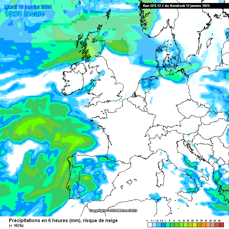
2 minutes ago, IDO said:
Yes, look at the moisture in that low:
We can see the oranges as they pass through the low countries. A bit further north, please, even if it may mean rain to snow further south.
Then ens on this gfs run
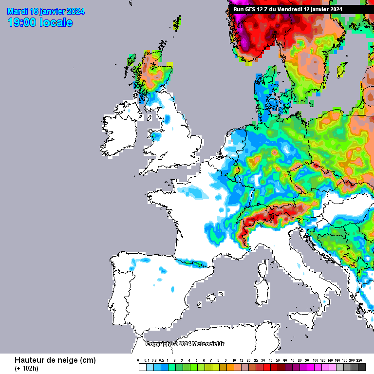
 will be interesting in the precipitation spike ticks.. for say London.. for a guise on possible direction of geographical land basing!! This is FAR FAR- from resolved!!@channel !!
-
7
-
-
The skirting system- leaves adequate sync for deeper cold penetration!!. All subjects to change, but we are slowly getting towards compact evolution!
-
1
-
-
Looks like a possibility of a pivot format here!! All subject to change- interesting nonetheless!!
-
2
-
-
- Popular Post
- Popular Post
-
9
-
1
-
8 minutes ago, Speedbird said:
barely a glancing blow on those frames, the northerly fast becoming a NW'ly barely affecting anywhere south of the Midlands
That’s not the case pal -8 hpa-entrenched sub uk wide!!
Edit: as per 1 of my earlier posts, it’s quite a baring difference in output going forward- once we actually have arctic air sitting across us- the Atlantic will behave according, but quite different I think…to what some are thinking!
-
5
-
-
Definitive slight upgrade via 6z ec a better aligned inflow- and we watch to the west as the much spoken above system sets sail to nw Europe- but we await as per dynamics!
-
3
-
-
2 minutes ago, TSNWK said:
Thing is the mild return is being driven by the vortex moving east to west over the polar regions I don’t think our local conditions are going to make much difference to the vortex moving over the polar regions and the subsequent impact of that to us.
You’d be surprised I think- the models will adjust/ align much sharper once we reach arctic infer/ draw.. plenty of scope here .

-
3
-
1
-
-
We need to remember- the cold is pretty much nailed on now.. And we must await how output deals with the formats once overhead for prolongment/ deeper cold/- or indeed breakdowns.So a lot to look out for from around Sunday onwards @ modeling wise.Anyway the snow opportunity’s in the oncoming incursion, to me look bountiful
-
7
-
-
Runner gate still well in the balance. And ec highlighting even a fairly modest mlb get good deep winter Synoptics in. We’ll see how the ec evolves to the end
-
2
-
-
Ukmo is a banger this morning.. And we have a lot to look at!.. the lps runner
is modeled “well south into nxt week via this model”. But has plenty of feature possibilities once into the northerly!.. All in all a good run. I’m locking off with the GFS upto 120 hrs atm…
12 minutes ago, northwestsnow said:It literally is the ….. GFmess right now !!
-
5
-
-
Just now, That ECM said:
I wish you wrote the met extended.

They don’t


-
5
-
 1
1
-
-
Ec 12z plots-ens… mustard upto the 22nd.. after that pick your pert/ member??!!… A cold spell is coming… the jackpot question- still remains, how notable.. n, how prolonged… Keep watching.
-
8
-


Model Output Discussion - Colder but how cold and for how long?
in Forecast Model Discussion
Posted · Edited by tight isobar
I’m still biasly optimistic . There’s another 48 hrs of modeling on this b4 assumption/ assurance…