


.jpg.66eb1d612a19e333068352f9a1a6b9ea.jpg)
.jpg.689334a3abd90b862654383e9bd4ca03.jpg)
wiltshire weather
-
Posts
299 -
Joined
-
Last visited
Content Type
Forums
Blogs
Gallery
Events
Learn About Weather and Meteorology
Community guides
Posts posted by wiltshire weather
-
-
3 minutes ago, Nick Croker said:
I like the look of the SNOW finger pointing my way out of South London.

Should give quite a covering for those who catch that shower train!
-
Seems to be a rash of showers headed our way from London right now:
-
 2
2
-
-
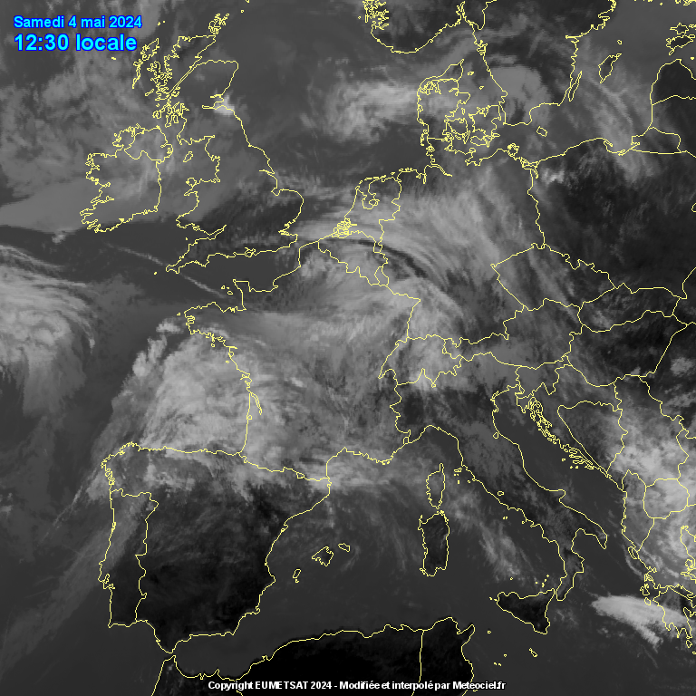
I'm not entirely sure the models etc. have got this correct yet.
Just looking at the latest ICON rolling out now and storm EMMA currently appears to be further east than that model run is showing.
For example in the satellite pic below, the front running down the south east coast of Italy is already well inland:
whereas the ICON has it not making that location untill 2300:
May not make an ounce of difference of course, but any correction eastward I think would be a good thing before it swings up towards us as the core of the heavier precipitation would hit our region instead of heading up to Ireland.
Also, I assume the further elongated the low pressure is eastwards, the more cold air it continues to pull in.
Either way, the ICON is still showing a decent snow event for the next two days even for me in the NE of our region
-
 2
2
-
-
Temp got down to -9.2c here last night, dont think we'll be breaking that for a while!
Keeping fingers crossed for all you guys along the south coast today.
-
1
-
-
This is exhausting! GFS upgrades as others have mentioned:
-
Maybe the answer in what Meto are seeing lies in their updated FAX charts for Thurs/Fri:
2 minutes ago, Mark N said:Especially for those NE in this thread.
Hirlam looks great for Thursday sends the first band North and less focus on moving it NW at that point..
I'd quite happily take those !
-
Updated ICON fragments the snow quite a bit. Still snow across the region Thurs but Friday looks like a non-event almost.
However, it does keep the cold going and apart from a brief warm-up early Friday morning, brings back colder 850 uppers (below 0 anyway) until Sunday evening (the end of its run).
-
1
-
-
-9.1c now.
Snowy pic from earlier this evening out with the dog during our one and only snowstorm so far:
-
5
-
-
Hmm, my forecast for tomorrow seems to have gone from sunny all day to cloudy with snow late afternoon/evening.
Wonder what has caused that to change? Not that I'm complaining mind!
-
3
-
-
Hah! Sorry for my earlier gaff! Forgot to put in the all important minus sign! What a plonker...
Anyway, now down from the earlier -6.9c to -7.8c here.
-
2
-
-
Temperature has dropped like a stone here after a snow storm left 2cms of snow cover in 20 mins earlier!
Already down to 6.9 deg c
-
Really looks like this is going to go down to the wire with changes right up to the event itself and even as it's happening!
I'm sure there will be both upgrades and downgrades along the way, what a fascinating hobby we have
-
1
-
-
3 minutes ago, AWD said:
Looks like too much PPN there. Probably to do with the grid resolution of the model.
Unfortunately, I think you're probably right! Seems the GEM always overdoes the precipitation...
-
1 minute ago, Nights King said:
Still time for this to improve for all of us further I think it will get pushed further south yet wednesday as models start to get a handle on it.
Could still get it stalling...
Note I posted the GFS again first of all, corrected my post now
-
Really, really hoping the GEM has got this nailed !
-
2
-
1
-
-
GFS 12z snow prediction Thurs-Fri
Not as good for me Thursday but better Friday. Seems similar to the ICON I posted earlier.
-
Updated ICON snow predictions for Thus-Sat:
-
1
-
-
Not entirely sure if the scale of this is in mm or cm, but here's the accumulated precipitation for Thurs going into Friday from the ARPEGE 6z:
Seems to match up with the warning area quite well.
-
2
-
-
-
4 minutes ago, Tamara said:
Hello people to my west
I thought I would visit and try and send some snow your way
The streamer that has given the cover here is showing signs of shifting west and some of you in the eastern part of your region should hopefully be seeing some very soon
Tomorrow looks good for those of you further west of your region as well
And then of course there is Thursday/Friday...
Good luck to all x
Lovely pics Tamara, hopefully we will all be seeing something like that over here as well
-
2
-
-
Even my Meto app has now got some snow showing for this afternoon!
-
Looks like the area over Kent is actually moving East, as well as the one coming down from the Midlands.
First image was at 1050, second one at 1200:
-
2
-
-
HIRLAM short range updated for the 6z - takes us up to Thursday and shows a lot of what @Bring Back1962-63 alluded to in his excellent analysis earlier (please go and read it if you can, it's on page 106 of this thread).
-
1
-
-
A late start getting online this morning and only just catching up, whilst the heaviest flurry we've had so far is on the go.
Thought I'd take a look at the various outputs for snow Thurs/Fri/Sat and its looking pretty good for our region as it stands, although the GEM isn't good from Friday onwards.
I'll do the ARPEGE shortly but its still updating its 06z run:
ICON 6z:
GFS 6z:
GEM 0z:


South West and Central Southern England Regional Weather Discussion 22/02/2018 Onwards
in Regional
Posted
As an appetizer, I'm quite happy to take what the HIRLAM is showing for tonight:
Fits in well with the showers showing up on the radar too:
Seems to be building off the Essex coast before moving across.