


Skullzrulerz
-
Posts
8,069 -
Joined
-
Last visited
Content Type
Forums
Blogs
Gallery
Events
Learn About Weather and Meteorology
Community guides
Posts posted by Skullzrulerz
-
-
Just now, Charlie Harnett said:
Peak of the winds here now in the red
Be aware that the Red Warning doesn't expire until 12am today, even if it's peaked in you're area.
-
 2
2
-
-
3 minutes ago, Nick L said:
All weather stations in Cornwall have recorded gusts of 60-70mph so far. It's gone exactly to forecast.
It's most likely because I live in the Southern part, even on though I'm about 200 meters the clay pit hilly areas are the saving grace.
Anyways I said my bit, and will no longer comment on this thread.
-
1
-
-
Still nothing of note so far, wind has died down and besides seeing leafs that's about it.
For this area it's been a let down so to speak which is a good thing.
-
-
Just now, BornFromTheVoid said:
Just lost power. No more weather updates from me
Stay safe!
-
3
-
-
So far, quite windy at the moment nothing out of the ordinary at current.
-
1
-
-
When does the ECM Update?
-
7 minutes ago, Jayces said:
I'm pretty sure the big pink area out to sea is thus due to it being flat so nothing to moderate the wind. As a rule coasts will always have the strongest gusts but inland they will be reduced by topography and buildings etc. So regardless of movement there will always be less pink overland. At least that's my take on it, I could be wrong of course.
Thank you for explaining, much appreciated.
-
1
-
-
6 minutes ago, Mark Smithy said:
There is no change from the Met Office red warning area and it is not true that there is any significant move northwards (which has been another of your tiresome little mantras). The only change is that the low appears to be deepening more significantly and rapidly than even the Met forecast at this early stage. That makes the pink area more, not less, extensive.
And I know exactly where Cornwall is, thanks.
To be frank you have spent the last few days constantly attempting to pooh-pooh this storm. This is what you posted:

The met office will reserve that right to update the Red Warning as they please, as said it will become a nowcasting situation as even you have said it's deeper then forecast.
Even small changes in positioning of said low can have big differences in some areas.
Thank you very much for bringing up my post, for you're information there's no wheelies bins out as bin day is cancelled.
-
Just now, Coopsy said:
93 mph for the SE. That’s going to be up there as one of the most powerful storms in a generation.
It's going to be a nowcasting situation, I understand that some people are criticising the met office and rightly so, but with these changes at short notice I would imagine how difficult it must be for their team.
-
5
-
-
5 minutes ago, Mark Smithy said:
It's also complete rubbish but you've been on one ever since you said it would be nothing more than "a bit of a breeze"
If this verified it would be more extensive than the existing Met Office red warning.
You do realize that most of the pink/purple area is thankfully north of Cornwall?
The resulting of a more northerly track is while Cornwall and the far west do avoid the worst it does mean that Wales/Bristol faces the brunt of it.
-
1
-
-
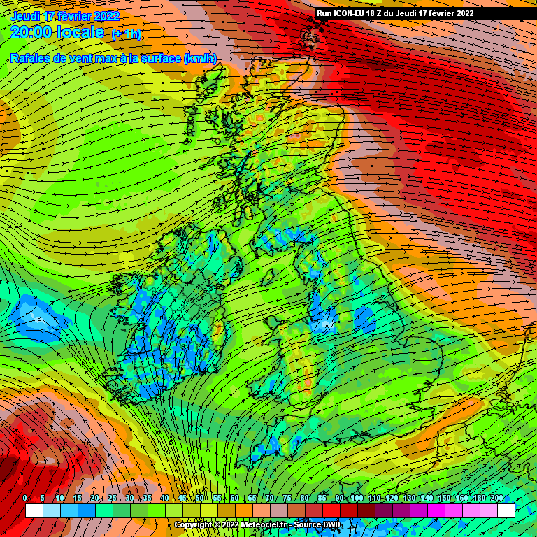
1 minute ago, Mike Poole said:
ICON-EU 18z take on it, looks a little further north and stronger to me than the 12z suite:
And with that shift North, Cornwall avoids the biggest pinkish areas.
-
A upgrade to winds in the South East, not good news at all.
-
If the storm is more north then forecast would that mean the far south west has less of the worst winds?
-
1
-
-
33 minutes ago, Midlander said:
Yeah it’s with in the 72mph contour line
Do you have a link so i can look at other places please?
-
1
-
-
3 minutes ago, Midlander said:
The St Austell area, that wind speed for gusts is 72mph? Can't really tell.
-
1
-
-
9 minutes ago, Man With Beard said:
ECM is out. Gusts of 89mph around Canterbury!
What about for Cornwall? Is the ECM has stronger winds this time?
-
1
-
-
11 minutes ago, Mark Smithy said:
Crikey. The 12z ICON-EU is pretty shocking across most of southern Britain.
Is the low further South this time?
-
Just now, Theresnoway said:
The Met Office Red has disappeared from the App, I wonder if they’re updating?
There's a new yellow warning for wind out for Saturday.
-
 1
1
-
-
Looking at the Met Office, so Bodmin has the same wind gusts as St Austell (slightly weaker non gusts) I don't understand why we are not in a red warning.
That's not to mention we have a higher population here.
-
1 minute ago, Met4Cast said:
You would struggle to find a more textbook example of what a storm looks like just before it starts bombing.
Rapid intensification is likely through this afternoon and overnight.
Nowcasting time, the question being will it be further south or north then forecasted?
-
1
-
-
Will the Red Warning include Southern Cornwall later on?
-
2 minutes ago, Nick L said:
Simply inadequate red warning from the Met Office.
What others areas did you think that the red warning would be issued?
-
1 minute ago, Mark Smithy said:
There we go. The Met Office clearly agrees!!
RED issued for north Devon and Cornwall. I imagine other places will follow later in the day.
St Austell is about 5-6 miles from that Red Warning area.
I'm surprised that southern Cornwall isn't in the red area.


South West and Central Southern England Regional Weather Discussion
in SW and CS England Weather Discussion
Posted
Got a big hail shower! Turning a bit white here