


SteveB
-
Posts
12,151 -
Joined
-
Last visited
-
Days Won
1
Content Type
Forums
Blogs
Gallery
Events
Learn About Weather and Meteorology
Community guides
Posts posted by SteveB
-
-
46 minutes ago, Seasonal Trim said:
Used to love this thread in my early days on this forum. Until I realised that snows progress across Europe doesn't matter a jot to what happens on our tiny Island of the edge of the Atlantic.
Seen a fast growth, slow growth, growth right up to the border of France and growth in every direction.
But nothing that indicates whether we're gonna get anything for us.
Such a shame.
Still a good thread though. Never get tired of seeing snow
 and ice
  .
.
Love the twitter thread too
-
 4
4
-
-
15 minutes ago, Don said:
Perhaps we should not even bother looking for cold this coming winter then?!

I didn't say that! The hunt for cold is fun, but the models just don't seem to get a handle on this side of the pond. When reality tells us that the serious cold spells shown in FI don't usually happen.
Even when the whole ensemble suite is showing cold it turns out to be a false dawn.
What's the saying..... even a broken clock is correct twice a day.
Maybe it will happen this year!
-
4
-
-
16 minutes ago, Catacol said:
October 50 year averages:

November 50 year averages
December 50 year averages
What are you seeing here?
And to play the game a bit further - how about recorded minimums?
October 50 year first
November
December
And - if you want to talk maximums and not simply cherry pick - here we go with November:
December....
Fred - it is time to stop peddling the idea that the world is about to go cold. It isn't. I will be a snow hoper until the day I die - but the world is warming....it is out of control....and our winter chances are fading fast. Cross fingers for a split vortex SSW because without one we need a very very favourable dice roll.
Only the ultra hard-core snow lovers are clinging onto the hope for a Winter like the ones we used to get pre 1980's.
Western Europe is locked into a perennial spell of mild Winters, and the stats back it up.
Yes there will be the odd cold spell, but they are becoming shorter and few and far between.
What I don't get, is why do the models have a proper cold spell in the far reaches of FI, and bring in forward right down to T120 or even T90 and then start to water it down to a two day cold spell or nothing at all. I thought the models programme in these failures and learn from them on future runs. It happened a fair few times last Winter and the one before that.
This year I would like to think the models and the programmer's have learnt something.
-
5
-
-
14 minutes ago, I remember Atlantic 252 said:
feel some records going again this year! last year was the tropical new years day, every setup now is less cold than same setup say 30 or so years ago, last Feb E'ly sucked as only gave wet snow,
tropical maritime air feel now could be 16-18, rather than 12-13
Agree!
This year I'm focusing on how warm and wet it's going to get, rather than chase fantasy BFTE or polar lows that never happen, but are continually shown in the far reaches of FI.
-
3
-
-
In my little part of the world, snow is a very rare thing indeed. 2009 and 2018 aside, every other winter has either been snowless or the odd day where snow has been falling but not settling or settling but gone within a few hours. I could probably count on two hands the amount of times that's happened over the last 13yrs.
Frosts seem to come later in the Winter, and some of the frostiest times are Feb/March time.
Gone are the days of frontal snow. Last time was the early 80's
I can't see anything changing soon, infact probably even less snow and frost is the most probable outcome.
-
4
-
-
22 minutes ago, Daniel* said:
At this point a return to near normal will be comforting this is favoured outcome into early November. Calling winter a dud in October is silly - remember our climate is known for variability, this year is being anomalously warm even on last decade it won’t persist forever.
Agree it won't persist forever, but it might persist for a lifetime.
-
Just now, Frostbite80 said:
I can see anything happening tbh no winter season is the same and just because we have had above average temps over the last few months has no indication on what the following months will hold, infact if you look at historical years where octobers have been warm....
I agree with all you say, but...... we haven't had a below average month this year, we are nearly into November and looking at almost record breaking high temps for the time of year.
It would be some turnaround and at the best time of year, to flip the above average temps to below average temps.
Maybe I've had my fingers burnt far to many time over the last several Winters looking at the models to believe any of them when they show blocked cold synoptic.
Until I see snow falling outside my window, nothing the models say or show will make me think cold is on the way.
I'll be looking out for record warm temps this Winter, and satisfy my weather interest in that, rather than chase fantasy beasts from the East.
-
1
-
-
4 minutes ago, Frostbite80 said:
No disrespect but we arnt even in november yet. Can we not give it a little longer before people shout warm or cold
A mild or even warm Winter really is the form horse.
Hand on heart, can you see anything else other than that this year?
-
1
-
-
5 minutes ago, Aleman said:
To get back on topic:
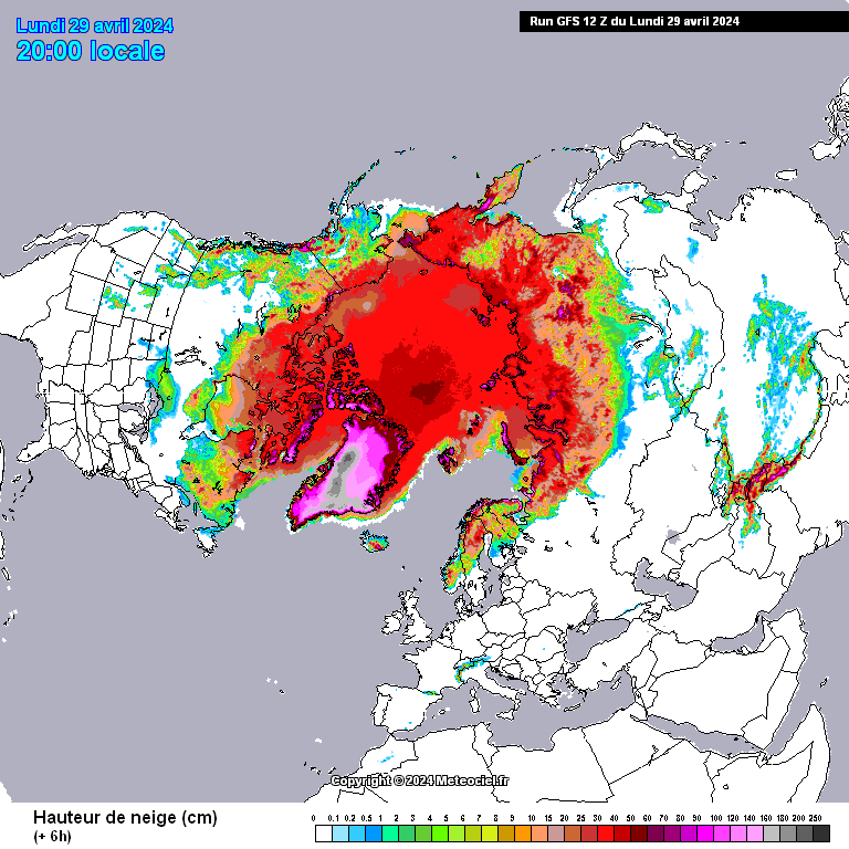
There's lots of new snow and ice after a bit of a pause. The main pack has linked to Alaska/Yukon and the low that brought those northerlies has driven widespread snow down the western USA, almost to the Mexican border. There's a bonus the latest system bringing some westward expansion to Russia. Meanwhile, Laptev is filling in.
It's fantastic to see everywhere else in the Northern hemisphere do well.
-
10 minutes ago, Catacol said:
A grain of truth in an otherwise off target assessment. Snow chances in the U.K. are reducing apace - the warmer sources of air to both north and east are well documented and observable. The sub tropical highs are edging north. The cooling stratosphere is enhancing vortex strength on average as the years roll by. It is true that extreme weather events are becoming more extreme as forecast by CC models, but few of these are of the icy cold variety. We will see more heat records, more storms emerging from the tropics to higher latitudes as our oceans warm. The U.K. is in absolutely the wrong place to avoid the warmest/wettest winter impacts of these.
The grain of truth lies in the ongoing chances of vortex disruption. Observation may be hinting that a warming world means more frequent vortex disruption events but in truth we don’t have the longitudinal record to be confident of that. And unless the vortex splits these events are not guaranteed to bring anything remarkable.
I agree that extreme events will occur and at some point snow will feature. I was in Santiago in 2007 when they saw snow at sea level for the first time in 40 years. These things happen. But we may also be edging ever closer to a context where, when they DO happen, our media will be reporting on “heaviest snow for 15 years” - because lowland snow in the south will become that rare. I say this with no joy whatever. I think we have passed a fairly substantial global tipping point in climate and for our generation there is no going back. Perhaps our grandchildren might see temperatures stabilise. Or perhaps politicians will continue to fail to act, and extremes magnified by +2 global averages will become an ongoing nightmare for many.
So sad to hear, but so very true.
-
3
-
-
I love your optimism, however, there is no escaping the fact that we are breaking more warm records than cold. And doesn't seem to be changing anytime soon.
While the rest of the Northern hemisphere can still get cold and snowy Winters, even record breaking cold Winters. The UK and indeed Western Europe seem to be stuck in a perpetual mild/warm pattern.
I fear the same thing happening this Winter as it did in Summer, high temperature records being broken.
I love this thread, because it allows me to see what cold and snowy weather looks like, while sitting here at home admiring the warm Autumn weather.
-
2
-
-
44 minutes ago, Don said:
It's difficult to get things to bode well for our winters these days with climate change really kicking in!
It loathes me to say it, but I think you're right.
-
2
-
-
Unfortunately I have to agree with you.
Something must be very wrong, if at the beginning of the Winter season, I'm wondering if I'll see any snow at all this season.
We live in depressing times in an equally depressing Country if it's snow and cold you like.
-
-
Nice little storm just rumbled on through.
Best storm for a long while, and incredibly the second one of the year.
-
4
-
-
28 minutes ago, RJBingham said:
Dec
Jan
Feb
Most of the world is on

-
11.8c and 58mm please
-
- Popular Post
- Popular Post
Don't really want anymore warmth.
The cool misty dry chilly part sounds better.
-
13
-
A bit of thunder and lightning here.
-
12 minutes ago, dr weather said:
Looks like Weston is going to get some action very shortly ...

It could still go wrong
-
8 minutes ago, MP-R said:
Well obviously, it was tongue in cheek haha.
If we get through this week with no storms… I really will declare the weather as dead! This setup is normally half decent for here.
I'm totally onboard with what you're saying.
-
1
-
-
2 minutes ago, Ben Sainsbury said:
Quite like yesterday I think we will likely see a few surprises! I'm gonna be heading out myself today, maybe around the Yeovil area?
I wouldn't bother even venturing anywhere near Weston - I don't think we will see anything, continuing on with the same theme as it has been all year..... no storms!
Hardly got any rain last night, let alone storms! It's been poor.
-
2
-
-
28 minutes ago, MP-R said:
iPhone app gives me 100% chance of thunder later… what could possibly go wrong…

Bright sunny start.
Everything!
Success rate for predicted thunderstorms to what has materialised has been 0% this year...... come to think of it...... most of the last several years!
I'll hold my breath, this week does look promising on most days - surely Weston can get an overhead storm?
-
14.9c and 86mm please


Snow and Ice in the Northern Hemisphere: Winter 22/23
in Spring Weather Discussion
Posted
It must be buried somewhere in the forum. Maybe a new one will be created!