


Nouska
-
Posts
1,331 -
Joined
-
Days Won
4
Content Type
Forums
Blogs
Gallery
Events
Learn About Weather and Meteorology
Community guides
Posts posted by Nouska
-
-
1 hour ago, frozencanals said:
afternoon all,
Wow what a contrast with the January cold, now we are sitting under a red warning for storm force winds this weekend.... so we are laying bets on when the power and phone lines will drop, first world problems eh?
Take care and stay safe everyone...
FC
Hi, yes, you too. It is looking like an exceptionally rough night and morning in your specific area. We've been chatting on a status update. The internet playing up badly now but don't know if it is weather related or something else - a bit temperamental like all utilities in rural France!
-
 2
2
-
-
- Popular Post
- Popular Post
I hope you guys realise I'm sacrificing my roof in order to set up your easterly.

-
56
-
5 minutes ago, Summer Sun said:
Short ens shows the Op on the warm side of the mean later next week
Full set should be out imminently
I think it is better to use the one with climatology - in this instance, they are all below climatology from the 8th.
-
4
-
-
Horrible forecast!
http://www.meteofrance.com/accueil
How long without power this time?
QuoteFrom Friday to Sunday, three active depressions will follow one another in France. They will be associated with violent gusts of wind and will maintain a strongly agitated and dangerous sea on the Atlantic coast. From this evening, very strong waves are expected on the Finistère which is placed in vigilance orange waves-submersion.
To monitor the situation, consult our forecasts and the vigilance map.
Friday 3 February, violent winds are expected to affect western France in the passage of a very hollow depression. At the end of the morning, gusts could reach 120-130 km / h on a coastal strip of southern Brittany in Pays de la Loire. They will quickly reach the northern coasts of Brittany and the Cotentin. Inland, gusts of the order of 100-110 km / h are expected from Brittany in the Pays de la Loire and up to Normandy. The sea will be strong and dangerous on the entire Atlantic coast.
Potentially very violent winds Saturday
In this well-established perturbed context, a new storm is expected to hit France on Saturday (February 4th). At this stage, the scenario envisaged is a trajectory running from the Charentes and Vendée coasts to the North-East through the Massif Central. As of the second part of the night from Friday to Saturday, the gusts could be locally very violent, sometimes reaching 150 km / h on the Charente and Vendée coast, 130 km / h along the Aquitaine coast. Inland, the wind will also blow very strong, up to 120 km / h on the Charentes and the Massif Central. The sea will remain dangerous on the coastline, particularly from the Vendée to the Spanish border where the risk of waves submersion will be high.
Another Depression on Sunday
On Sunday, a new depression could affect the country with strong winds on the coast and inland. However, its trajectory and intensity remain to be specified. The southern regions may also be affected by these strong winds.Update with the 12Z models.
Nasty squall line modelled before the wind comes in with full force.
Strongest winds reaching your area Spike.
-
2
-
-
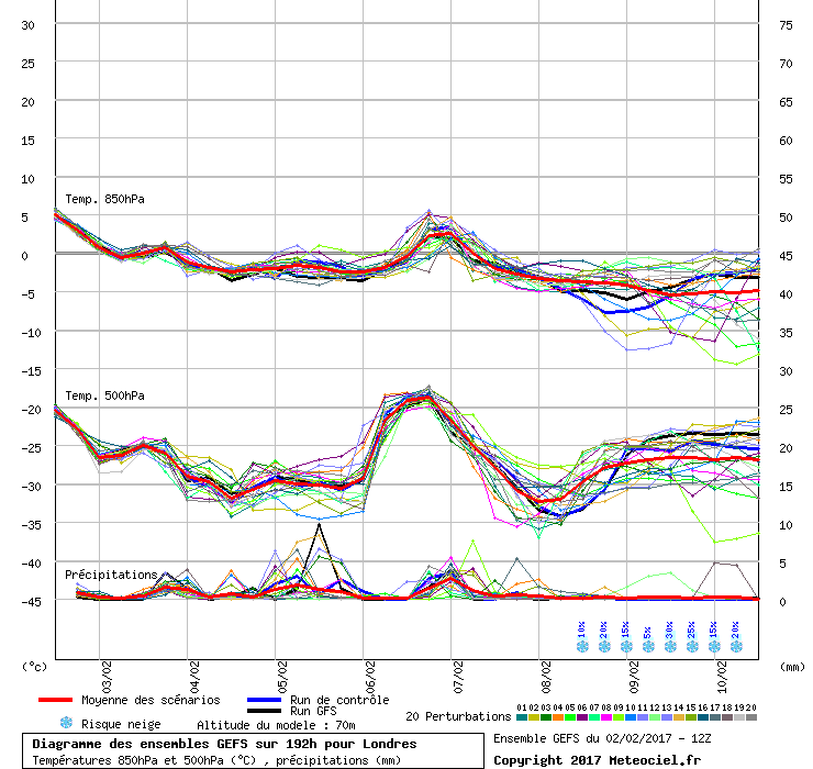
Comparing the latest ensembles for SW Holland to the 12Zrun I posted last night.
There is still the 'shadow' of the previous run but much of the scatter afterwards has been resolved. There may be six clusters but a good percentage of them go easterly as early as the 7th.
Looking at the extended EPS means - cold 850 temperatures right the way to the end of the run.
eg.
Edit to say - loving the up to the top button!
-
5
-
-
- Popular Post
- Popular Post
1 hour ago, Ali1977 said:Easterly quadrant flow favoured by day 10 - but not a done deal by any means.
The wind direction from SW Holland (closer to SE UK than De bilt) sector tells that story. Rapid swings as the storms rush through, hit the block, then the flatlining in an easterly. Too much scatter for complete confidence but I don't see any other definitive cluster apart from the easterly one.
-
15
-
- Popular Post
- Popular Post
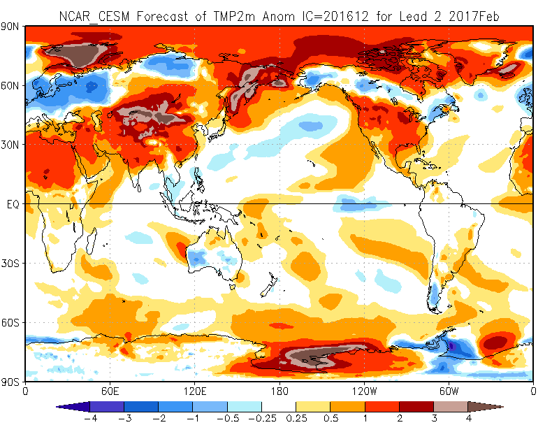
On 07/12/2016 at 17:10, Nouska said:The one long range model I have been impressed by - NCAR CESM - had been consistently showing a very cool picture for February - blinked last month - now back again . I know it is ice anomaly coupled but no idea as to whether it has stratosphere forecasting abilities. This sees the October/November pattern re-establishing with the cold managing to penetrate as far as the UK.
This is the model that Dr Ventrice has been singing the praises of, from a USA point of view. A rare success in model terms for October too, Eurasia wise.
http://www.cesm.ucar.edu/about/
In view of current modelling, thought I would repost this again.
Will this be another success for the NCAR CESM and will the cold get as far as it forecasts it to - I have more confidence this time - in both the model and what it shows.
-
11
-
This mornings ECM 360 hour ensemble mean still looking good - sees the Scandinavian high pressure still present at a good latitude, Atlantic kept at bay and indications of very southerly jet stream. The mean 850 temps not very low but do not need to be with a continental feed.
Probabilities for T850 < -8C coming in from the east, starting to make an appearance.
-
7
-
-
A risk of a 'so near, yet so far' scenario when two of the stations are west and only one east - based on what has gone before, I'll opt for same figure as January as that seems to have been quite accurate.
3,9C.
-
1
-
-
The ECM 360 hour MSLP ensemble mean is an interesting chart as in there appears to be no connector to the Atlantic on the isobars - if I'm reading correctly, the east is the player and the spread for the south is quite low at fifteen days in the future.
-
5
-
-
Well, there are some historic cold February months in the NOAA upstream analogues derived from the GFS 06Z run!
http://www.cpc.ncep.noaa.gov/products/predictions/short_range/tools/model_guidance.php?dayin=11
Why do those conundrums always feature on the last day of the month - when CET competition requires an entry.....decisions, decisions.... the ECM not buying it as yet and remembering sudden swing on cusp of the last two months.
-
6
-
-
Just now, nick sussex said:
That looks better than yesterdays forecast, the phase 5 composite looks quite close to both the ECM/GFS outputs which could suggest we're seeing the MJO impacting more on the NH pattern. NCEP update their overview later so hopefully that sticks to last weeks suggestions that we'll be seeing less interference on the MJO.
It's interesting to note that the last two major SSWs coincided with that MJO phasing in a high amplitude.
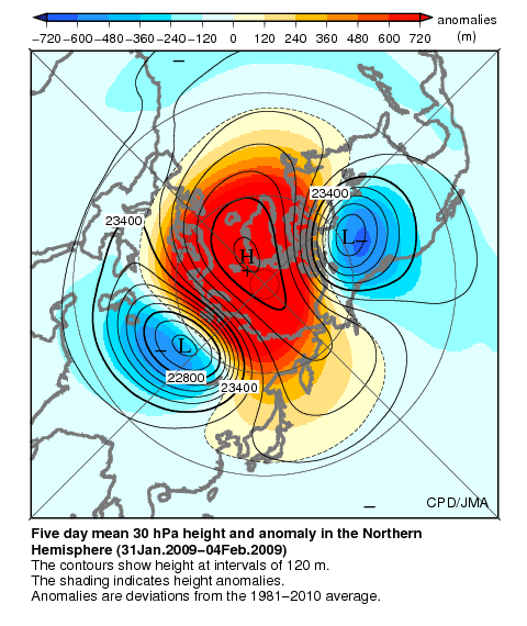
Jan '09
Jan '13 There's maybe something in the theory you were reading about in that paper - difficult to identify the chicken or the egg as the jump coincides with SSW commencement on 6th January 2013 but MJO leads well ahead of SSW date 24th January 2009.
http://ds.data.jma.go.jp/gmd/tcc/tcc/products/clisys/mjo/monitor.html
-
9
-
-
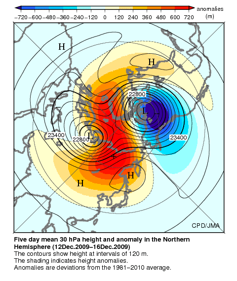
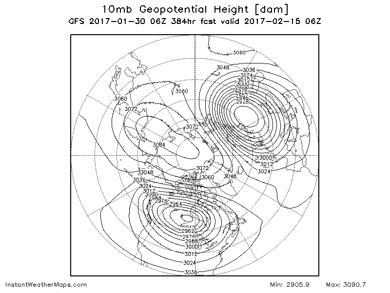
5 minutes ago, chionomaniac said:
That was the record breaker SSW - from 'over the top'. The ones I am thinking of occurred late 2009 and 2010 and involved trop induced splitting propagating upwards on a weak vortex before it had a chance to get it's act together.
OK ... here they are - if same time frames you are thinking of.
Dec 09
Nov 10 -
6
-
-
7 minutes ago, chionomaniac said:
Yes, it's happened before 2009/10, 2010/11 ( I think) but the split was Greenland based.
January 2009 split had heights centred over Greenland.
Compare GFS 06Z forecast split with heights focused on eastern Siberia.
Would the end result not be similar or is there a risk of the two lows rejoining over the Atlantic when the core heights are not in that sector?
-
5
-
-
1 hour ago, bluearmy said:
There must be something on the nw site re this chris - perhaps the first page of the strat thread?
anyway, wave 1 will be driven by one wave (usually from one big ridge ) whereas wave 2 requires two ridges ( see upcoming trop pattern with big n Pacific and scandi ridges into the polar field)
these waves can be driven from the trop upwards or the strat down
I don't know if it is mentioned in the first page or not but this question asked many times over the years. There is a good explanation in a specific thread in the learners section. Unfortunately some of the visuals are missing. Maybe an idea to link this in the opening post of the strat thread.
-
4
-
-
28 minutes ago, nick sussex said:
It's really at the moment trying to scrape some interest until we see a change upstream, all our eggs are really in the strat warming weakening the PV and the MJO together working to bring about a change to the NH pattern to help deliver a better chance of some snow and deeper cold.
There are more promising signs of a wave2 development on the 06Z GFS - that would be the first step to get a better pattern above and then rely on this being reflected further down.
from this
to this At first glance, it may seem as if the core vortex is setting up in the worst possible location but there are plenty of historical situations where this has worked out well if a proper split occurs - simply because of the suggestion from Ed (I think) that the jet does not cross the split.
-
9
-
-
1 minute ago, Ruben Amsterdam said:
First nacreous clouds spotted near Tromsø, Norway. Very spectacular sunset here in Oslo, also due to the cold stratosphere (allthough I personally did not observe any "classic" pearly clouds. All signs that the vortex is indeed displaced.
Thanks Ruben.
The forecast penetration of a very cold strat over the UK was overdone on the first phase but looking better for the weekend with -84C overhead - should verify at such close range. Question - will there be clear enough skies to view and are there other missing factors to consider in the formation of nacreous clouds?
-
1
-
-
55 minutes ago, feb1991blizzard said:
Its more important where the Ridge / vortex or vortices position themselves after the warming, On that 192 chart, if there wasn't another warming immanent, the vortex would quickly move back over the pole, I'm guessing here but probably with negligible effect on the troposphere.
Agreed - just as an example, I'll include the SSW reanalysis charts for 2006 that I posted in the winter thread.
pre 2006 SSW - almost identical to the current displacement.
Afterwards the vortex moved over the Eurasian land mass and led to a colder pattern for the UK. This is the type of response Cohen is looking for in his recent report and what @Singularity was describing, either here or in the model thread.
I'm not seeing that yet as the tendency this time is to want to move back polewards after each wave of warming. The QBO was east phase back in 2006 - the fact we are in a strongly west phase may be what is preventing the final push.
2 minutes ago, booferking said:Does the 06z get us any closer to 2006?
Looking at the temperature chart does not help here - need to look at the geopotential heights charts that go with it.
-
4
-
-
11 hours ago, Jason M said:
Nope not kidding, its a Bartlett set up. Persistent band of high pressure to our SE. Its not exactly the same as the 1988 version of course and as said above it might not happen like that, but IMHO the 18z is a Bartlett set up (much like most of Dec tbh).
A Bartlett, you say .... "not exactly the same as 1988 version" ..... damned right - nothing at all like the '88 orange monster.
I've never seen a 'blue Bartlett' before ... maybe it's been affected by all the European cold.
What you are seeing is mostly returning polar maritime air - a Bartlett has very warm upper air, centred over France, and feeds a constant train of tropical maritime air into the UK.
Compare the 18Z animation to a typical Bartlett type chart.
-
9
-
-
32 minutes ago, MP-R said:
We'd need February to be chilly though. 01st-11th and 19th-28th were cold periods, with a period of cool Atlanticness in the middle. February already looks like starting in, not only contrary vein, but also quite unusually Atlantic-dominated.
Interesting to note that the SSW of January 21st 2006 was preceded by an almost identical pattern of warming and geopotential heights as are forecast for this one.
The pattern that followed was different to what is being modelled in the far reaches of GFS. Back then the vortex buried itself deep over the landmass of Eurasia but on this occasion it is forecast to keep more over the N.Scandinavian sector.
-
2
-
-
Hmm... see references to SSW January 2013 similarity in model thread. Yes, immediate response to initial warming might be similar but a split vortex followed very rapidly. Nothing like this currently showing in stratospheric levels but that's not to say it will not occur, should there be a technical reversal of zonal winds as was the case back then.
Edit for @Allseasons-si to show projected day 12 forecast.
No signs of a split on GFS and not on ECM at day 10 either.
The problem with the displacement is there is still the tail going back to NE Canada - not allowing the separation for heights to build in the gap. It's a strange year of disconnects - could still allow for something different to evolve from tropospheric up rather than strat down.
-
5
-
-
34 minutes ago, feb1991blizzard said:
Just wondering what did week 5 of the EC46 look like, looked like week 4 might have been a transition week?
I posted the week 5 T850 chart on the strat thread - cold southern UK and down here.
-
2
-
-
We go from this ...
to this ....
The models will be playing around with what the effects are at the surface but the current move to a southerly jet stream looks like a fairly quick response to the strat picture or am I missing something?
-
6
-
-
1 hour ago, Paul_1978 said:
I'm surprised that nobody picked up on his follow up to an earlier SSW tweet.
Just guessing, as he says or are there signs in the longer range products they use.
Late February on the EC46 has suggestion of negative T850 to the south and heights raised over N. Scandinavia.
-
4
-


 Jan '13
 Nov 10
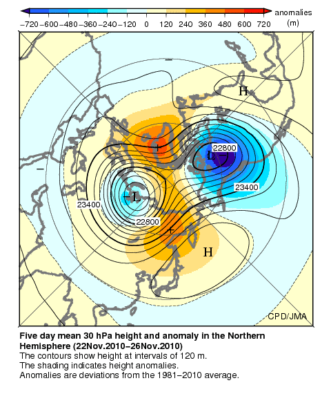
 to this


France weather
in Weather Around The World
Posted
A wee touch north again on the 12Z AROME and a more south westerly angle of approach. I might just dodge the worst of this bullet. Dry slot appearing on water vapour satellite - they must be reckoning on a sting jet with the forecast wind speeds.
AROME ARPEGE
Source.
http://brunnur.vedur.is/myndir/seviri/2017/02/03/seviri_eurnat_wv6-2.html