


Paul Sherman
-
Posts
8,809 -
Joined
-
Last visited
-
Days Won
26
Content Type
Forums
Blogs
Gallery
Events
Learn About Weather and Meteorology
Community guides
Everything posted by Paul Sherman
-
Storm & Convective Discussion 12z 21/7/14 ------>
Paul Sherman replied to A.J's topic in Storms & Severe Weather
Flashbang, All the pointers were there yesterday afternoon, you could have even checked the BBC Weather page and clicked the link for the broadcast they do which showed Thunderstorms in the early hours of monday, a few pages back there is a link to Model forecasts of where they put the storms at 2-4am this morning, they nailed the Essex storms but failed on the East Sussex Convergence Storms. I was very close to going North of Chelmsford at 1am and sitting it out but gambled and opted out last night, still got a Decent Storm at 4am but the best lightning in the dark was Stansted, Saffrom Waldon and Brighton area last night. Why dont you utilise the free charts from Netweather which show Cape, LI, Converging winds etc, also gives modelled precip etc, your whining posts are totally wrong this morning as all the signs were there for a convergence zone from The Wash to The South Coast on all yesterdays models! -
2 very close Bolts here in Leigh On Sea but all quiet now, first at 350am and second around 4am, nothing but rain since!
-
Storm & Convective Discussion 12z 21/7/14 ------>
Paul Sherman replied to A.J's topic in Storms & Severe Weather
Not a drop of rain today here but thundering most of the day, the very nature of these hit n miss torrential storms, took a drive to Wat Tyler earlier and was in torrential rain just 4 miles from my house so you dont have to go far! -
Storm & Convective Discussion 12z 21/7/14 ------>
Paul Sherman replied to A.J's topic in Storms & Severe Weather
From the pictures I have seen it was 100% a Supercell no questions asked at all IMHO And I have seen a few Supercells in my time. Everything supported it as well, with SE Surface winds, 30kts of Deep layer Shear, 82f temperatures with 68f Dewpoints, NE Of a Low Pressure moving from North west France to Northern England by the end of the day. It had a persistantly rotating mesocyclone from pretty much all the pictures I have seen of this from Swindon to Oxford and and others have said the classic radar signature as well. Great catch and a rare visitor to the Uk Mainland -
Storm & Convective Discussion 12z 21/7/14 ------>
Paul Sherman replied to A.J's topic in Storms & Severe Weather
There are always going to be winners and losers, thats the very nature of Thunderstorms if you are in a static location, if you get out and about then you have a much better chance. For Leigh On Sea it was a fantastic 4 Days, I would also say Kent and Dorset did very well also, this backed up by the lightning maps from the 4 day event. Thursday nights Storm was a bit of a bonus with a Bifurcated Trough pushing Storms North West and North East (The North-East part was not meant to happen but once the trough started to Bifurcate in the Channel it was suddenly game on) It was some of the best Elevated Lightning I have seen in 15 years in this part of the world. Friday Nights Storms were in 2 parts, The first part was from 3 Surface Based Supercells that were just the other side of the Channel near Rouens that drifted North on the Southerly Flow, This hit SE Essex around 9pm and went on until 1030pm, once again some great Elevated Cg Lightning and a beautiful Gust Front (Not as nice as the South Coast though) The Second part of Friday nights storms came along at 3am until 6am on Saturday Morning and was mainly IC Lightning with sporadic Cg's thrown in, the best part about this storm was the constant lightning for 3 hours lighting up the bedroom, it really was non stop. I was away for Saturday in West Wales at a BBQ But had chatted to some other chasers and we plumped for Oxford as a location for possible Supercells so would have been all over that (Sods Law) but was glad the forecast verified in that respect. I also missed Sundays CZ Storms that initiated over Leigh On Sea, Hail, CG Lightning, Flooding and damaged roads around these parts greeted me on my return at 6pm. Guess SE Essex was lucky this time around but am expecting other parts of the country to get in on the action end of this week as Easterlies at the surface are never good for locations East of London in Homegrown Storms, so maybe some of the members who missed out will be in the action Wed-Friday! Good Luck All! -
Lol Oh the Irony, Mrs Shermanator sent me a message at exactly the time you posted this also geefully telling me this was happening with hail as well, where was I - On the bloody M6! Payoff was some superb structure near Peterborough and Cambridge today (y)
- 3,744 replies
-
- 1
-

-
- plume
- thunderstorms
- (and 4 more)
-
Lol it was pretty lively in my part of Essex for a good 2 hours!
- 3,744 replies
-
- 6
-
-
- plume
- thunderstorms
- (and 4 more)
-
1 More from me focusing on the Shelf Cloud Structure

- 3,744 replies
-
- 9
-
-
- plume
- thunderstorms
- (and 4 more)
-
Not a bad evening, some luverly Cgs over Kentishire this evening and a Shelf To Die For although picturing it was a bugger in the fading light.
- 3,744 replies
-
- 19
-
-
- plume
- thunderstorms
- (and 4 more)
-
Some Skies that look more akin to Florida here atm in SE Essex, lovely Storm to my South being lit up pink by the rising sun. A nice Cg from 330am this morning from a Severe Storm near Leigh On Sea
-
Thanks for the heads up Nanu, saw those on radar, hoping these clear off today though so we can get that heat building for tonights Main Course!
-
One of the best Elevated Storms I can remember here in SE Essex hit at 3am, rudely woke me up but these were worth it. Bring on tonight! The last few literally were hitting a few hundred yards away so even I retreated to the Kitchen whilst the bad boys were striking! Paul S
- 3,744 replies
-
- 13
-
-
- plume
- thunderstorms
- (and 4 more)
-
Where from ? The Cherbourg Area ? Those Storms are Surface Based so doubt they will cross the channel in 1 piece, might be a few grumbles along the south coast but would not expect much in the SE Tonight, we need the Plume to destabilise tomorrow evening and the release of the ML Cape.
-
Certainly was a memorable one, T/T/d of 84/77 that day, 40kts of Deep Layer Shear, Dryline, 5,500Jkg Of Cape, these are not too far from what is being progged by ECM/GFS Still although I expect it to downgrade quite a bit. Our biggest enemy where we are situated is actually France with big MCS Storms pushing forward their anvil shields and killing off the next days chances, 28th June 2012 was a bit different with those Storms initiating in clear air over Worcestershire, Gloucestershire etc and moving into untouched / unworked air, the System the night before headed up through the NW/ Wales and Irish Sea, so do we really want the MCS Tomorrow night ?? With regards to Strongest in the Uk if you look on the Torro Site there have been 2 x T8 (EF4) Tornadoes in the last thousand years, there was also a 1 Mile Wide Wedge in Herefordshire and the Longest track was from West of London all the way to the North Norfolk Coast, some 115 miles on the ground.
- 3,744 replies
-
- 2
-
-
- plume
- thunderstorms
- (and 4 more)
-
Its not hard to see why those Supercell Composites are very favourable, Deep Layer Shear On The Order Of 30-40kts, T/T/d of 84/71 and a Neg Tilt Trough are the perfect ingredients for Supercells to form, we ideally look for anything over 30kts as a rule of thumb when chasing these systems in Tornado Alley The big old question is wether Surface Heating and indeed a Surface Based Storm can utilise that 2,000jkg of energy, we only have a very small land mass to get these things done.
- 3,744 replies
-
- 5
-
-
- plume
- thunderstorms
- (and 4 more)
-
All depends on todays 12z runs I guess, Usually we see a shift eastwards and this will be key for either Fri into Saturday or Saturday into Sunday, I reckon we will do ok from this as the Plume destabilises from the west over the next 3 days!
- 3,744 replies
-
- 2
-
-
- plume
- thunderstorms
- (and 4 more)
-
Not often you see a shift west in the model output, would take that as a good sign, we dont want Belgium, Holland and France getting the clippers again. Will be heading somewhere just south of the Midlands Friday Night for hopefully some elevated lightning coming up through the spine of the country. Hand is forced for Saturday as Arron is hosting the annual Stormchasers BBQ This year in Aberwystwyth so will be heading North to Brum and then west into wales via Welshpool during the morning and early afternoon, could be a lively old drive towards the West Midlands, downside to heading west could be the development of the plume breaking down Saturday night into Sunday on home turf which is why I am heading out Friday evening. Good luck all and if some home grown surface based storms can fire the temp/t/d, available Cape and 30-40knts of Deep Layer Shear would be enough for Very Severe Storms for the Uk. Edit: Also had to laugh at an earlier comment on Lincs missing out - Seriously ? Both days look good for that location as is always the case! Paul S
- 3,744 replies
-
- 7
-
-
- plume
- thunderstorms
- (and 4 more)
-
Thats a Wrap! 52 days of action packed chasing with 22,500 Miles covered across 17 States thats just over 400 miles per day. 27 Tornadoes including 4 x EF4's, a couple of EF3's and a few EF2's in the mix. Nebraska topped our list with 17 Tornadoes, Followed by 3 each in Texas and South Dakota. 2 in Colorado and 1 each in Kansas and New Mexico. My structure award goes to Roswell on 7th June with that 9 stacked Mothership and close runner up in Kansas on 10th May. Would like to give a huge thanks to the staff who put up with me for 7 weeks and the great guests we had along for the ride. Hope to see a lot of you at the BBQ In Wales in July and Here's to the 2015 Season being another great opportunity to see the biggest Storms on Planet Earth. See ya under the Meso next year. Will update with pictures over the next few days!
-
The Northern target verified with some pretty structures, hail bows and large hail for the last day. Some pictures.
-
Going to take our chances with another Greeley monster today Neil. Want to be close to Denver for tomorrows flights as well. Thanks for following us this year
-
Weather gods are being kind and our last 2 chase days look like being Easterly Upslope Storms in and around the Denver area and with the flight back on Wednesday evening this is perfect for us, starting the day in NE Colorado so not far to go for todays risk, looking for some supercell structures today. Paul S
-
June 17th 2014 - Nebraska serves up 6 more tornadoes!
Paul Sherman posted a topic in Storm Chase USA
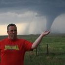
Just the 6 Tornadoes today in Nebraska, most at night but the 1 mile wide wedge was nice to chase at about 8pm tonight. Another Incredible Days Chasing in Nebraska which takes the season tally to 24 (Equal Best) and 13 in 2 Days! Had to have our wits about us at darkness with 3 Tornadoes surrounding us to our West North and East but seeing them dance about in the strobe lightning was so peacefull! Glad that Coleridge pretty much dodged a loaded gun today and most of the tornadoes stayed over open land, the only power flashes we saw were power lines getting brought down. Some Pictures from this amazing day with Tornadoes 1, 5 and 6 shown here. The two Stovepipes were churning away at the same time with a cone to our west, it was which way to shoot at times.
-
7 Tornadoes today (Including 5 Wedges) takes me to 100 Not Out!! Just a couple of the 100's of pictures we got with these beasts coming straight at us at times, twice we had 2 on the ground at once, some shameless plugging for the Netweather Tours as well
-
Yep we are firmly in that area Neil. thanks for starting the thread
-
Left Cheyenne for the Drive South to Denver picking up our final tour 4 guest then off towards the North East. At brush we took 71 south chasing the tail end Charlie. Initially LP with a nice clear base but soon morphed into an HP beast catching a glimpse of a tornado in the distance. As we ran out of road options we were caught under the base and hit with giant hail, possibly 4-5 inch smashing both windscreens. Rich caught this must see video of the Hail. As we headed east into Kansas licking our wounds this dirty storm hadn't finished with us yet. Finding it it hard to keep alongside this huge monster we edged through the thick cloud of outflow dust and debris. Stopping to refuel the storm caught us up and we just made it out of town before the wall of dust once again descended passing Dominator 4 on the way. We arrived in Colby Kansas to be greeted by a barrage of Hail and strong winds that would later increase to a 115mph straight line passing through Kansas and parts of Nebraska leaving a trail of destruction in its wake. No Streaming or GPS on Tour 4 but you can follow our chases on Spotter Network ID: Nick Parnell


