


Paul Sherman
-
Posts
8,809 -
Joined
-
Last visited
-
Days Won
26
Content Type
Forums
Blogs
Gallery
Events
Learn About Weather and Meteorology
Community guides
Everything posted by Paul Sherman
-
Day 9 of Tour 2 looks messy and not great for severe potential and thats why the See Text Risk is valid, not expecting a Slight Risk upgrade today so will meander upto the clear Skies in NE Colorado hoping that some of these front range storms can put on some hail and lightning, not expecting anything structure wise today but Colorado can do magical things sometimes, expecting the Slight to be extended down to the Panhandles tomorrow so should be some action on the way back to DFW Saturday as well. Sunday looks amazing in Western Kansas at the moment but due to a late straggler we cant unfortunately make that risk.
-
See you guys over the weekend, tour 3 currently looking very active for the start so you should be all knackered by the middle of next week and possibly sick of lightning by next wednesday lol
-
It really had been a High Plains season in 2014 and once again we will be driving towards Colorado from our starting position of Amarillo. Could be a few storms pop up along the way but looking really to poisition for Tour 2's last feasible chase day on Friday in NE Colorado and SE Wyoming before the trip back Saturday away from a very nice Slight Risk which is going to hurt (Hey Ho) Paul S
-
Tom as Paul is driving today - re-location day yes was under the canopy of the hotel. Trees were everywhere.
-
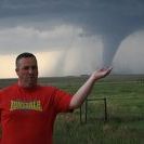
Pretty much a carbon copy of what Stu saw in the daily thread with almost identical pictures lol. Started in Hobbs and had the first Supercell of the day near Seminole go up and chased this towards Lamesa, saw a bried birdfart tornado with this Supercell, binned this for a Classic Supercell further South-West and watched it travel towards Garden City where we witnessed a multi vortex just east of the town, just about dodged the 3.5" Hail near Sterling City and witnessed a nice rope tornado near Broome, travelled to San Angelo for the night and got cored at the hotel by small hail and an amazing Cg which hit across the road, ate in Applebys with tonnes of chasers. A great day with 3 Tornadoes for the guests who are really pleased!

-
Starting in Sonora and pretty much rince and repeat from Saturday with another 5% Tornado Risk, looks messy again with a few outflow boundaries scattered around the place, expecting messy HP Supercells once again with stunning shelf clouds. Paul S
-
Reports & Pictures Chase Day 13 - New Mexico
Paul Sherman replied to Paul Sherman's topic in Storm Chase USA
Both shots were shot outside in clean air on a hotel balcony, also have video evidence with the same thing as well, would that be internal camera reflections as well on a video camera ? -
Reports & Pictures Chase Day 13 - New Mexico
Paul Sherman replied to Paul Sherman's topic in Storm Chase USA
Just seen the Super Slo-Mo of this and it does indeed match that description Neil, very excited about this. -
Reports & Pictures Chase Day 13 - New Mexico
Paul Sherman replied to Paul Sherman's topic in Storm Chase USA
Hi Ian Yes we have 2 pictures from Graham and John Finney that I will upload now, also have video from dave vicary. Hopefully someone can shed some light on this
-
Started the day in Lamar (C Eastern Colorado) with a chase target in mind of Hobbs to Carlsbad and that played out very nicely with 2 LP Supercells coming off the mountains and onto the Plains. Both were visually stunning and both were getting their arses kicked by a tornado warned storm heading northbound in the 500mb Southerly Flow. Ended the day in Carlsbad with severe storm after severe storm just to the west of town, it was here we also think we have captured an extremely rare instance of ball lightning, with 2 visual, 1 video recording and 2 Cameras picking up a fast moving green orb. Regards Paul S
-
Started the day in Burlington and drifted west to round 2 of the DCVZ (Denver Cyclone) one limiting factor today was upper winds which were quite weak at 20kts. We got one of the best storms of the day near Byers and saw some decent structure for a time before it all fell apart. Drifted back west to near Burlington and shot some great Cg Lightning to end the day. Southbound tomorrow.
- 1 reply
-
- 2
-

-
Some really nice Structure near Byers (CO) Today before it crapped out, now gunna play with the Lightning in Eastern Colorado before the journey south for tomorrow. Piccies Later!
-
Everyone is meeting up today after both cars split the risks yesterday with Amarillo and Colorado being the targets. Today's risk is minimal with only Multi Cell Storms expected due to lack of flow aloft with 25kts expected. So with the Panhandles in mind for Friday and Saturday we wil head south from our overnight location of Burlington and have a bit of fun with some hail and lightning, you never know something might structure up but not holding my breath today. In fact could actually be some DCVZ Action again today with possible Supercells so might have a dabble with that Regards Paul S
- 1 reply
-
- 1
-
-
Tom here as Paul is driving at the moment. We are just trying the get out of Fort Worth , road works a nightmare. Two vans rolling as Dave has taken a hit for the team and will be following on later once the two final guest arrive. we will meet up with them tomorrow. John is driving the second vehicle. Our destination is to begin with is Goodland, Kansas. Over and out for now.
-
Chase Day 8 Discussion - Slight Risk WY, MT
Paul Sherman replied to nsrobins's topic in Storm Chase USA
Just crossed into Wyoming which makes it the 10th State on this trip and a new record for the Netweather tours beating the 9 from a few years ago. Champagne corks popping here -
Chase Day 8 Discussion - Slight Risk WY, MT
Paul Sherman replied to nsrobins's topic in Storm Chase USA
We are on the Wyoming / Nebraska Border and will be leaving for the northbound journey in the next few hours, expecting a few supercells to head eastbound later on and with one eye on changeover on Wednesday and being 1,200 miles away we will have to think later about the trip back south. Hoping for some nice structure today above most else -
Long drive today to get in to position for the risk tomorrow in Wyoming. Hoping to see temps above 60f for the first time in 3 days lol
-
Just heading south from Louiseville atm, getting underneath the warm front for the storms coming up from Central Southern Kentucky, cant make Ohio with 3 main cities in the way
-
Yep Nick is right on all of that, it will be the furthest east any tour has ever gone, will be sitting underneath that warm front in Northern Kentucky Indiana or SW Ohio. Cannot disagree with anything Nick says there, LP Moving North East from Kentucky and hope to grab something under the warm front later. Wish us luck in chase terrain none of us have ever done before.
-
Brief Outline of our chase yesterday. Started in St Jo (Missouri) and tracked an elevated storm that became surface based briefly in SE Iowa, as it crossed the Mississippi into Illinois the Cold Front caught it and it went back into Linear Mode. Was good to see the transition from High Based to HP To Linear. Couple of pictures from yesterday.
-
Chase Day 1 Discussion - MODERATE risk KS/NE
Paul Sherman replied to nsrobins's topic in Storm Chase USA
Very tough chase today, witnessed a Multi Vortex near Clay Centre, then followed the HP East to Highway 81 where we saw it cross 500 yards in front of us ripping some sheet metal and flinging it across the road, took the next east road from Exeter to drive alongside a White Cone Tornado, mad RFD And Power lines down along the way, then stair stepped North to Highway 71 and saw the edges of the Corvonia Wedge about 12 miles North of Lincoln. Knackered but 4 Tornadoes in 2 Days and 1,200 Miles was very worth it! Sleeeeeeeep Time! Pictures on Phone so will have to somehow transport them over to photoshop to resize -
Am actually really happy with how today is shaping up, should clouds and left over storms move away and destabilisation occur then 2,500jpg of Cape and 40kts of Bulk Shear will easily support Supercell Structures over Iowa and Missouri, was not expecting the 5% Tornado Risk must admit. This could turn out to be a decent day, Target in the Morning. Night all after a Mad Mad Day in Nebraska!
-
We left DFW At 9am and had 2 targets in mind, the first was Northern Missouri and the 2nd the dryline in Southern Kansas, the 2nd target kind of fell into our laps so we went with that. Upn entering Kansas at South Haven we positioned ourselves near the first developing dryline storm, we chased this and kept an eye on it and then did the classic stair stepping down to the next one. The 2nd cell became a very nice Classic Supercell with super fast rotation, but this could not get the job done, it did have some very nice structure though. At this time another storm to our west caught our attention and quickly became supercellular, this one really put on a show and was a huge Classic Supercell Wedding Cake and looked like a pancake. Not as much rotation with this one though but an amazing sight. This was fast becoming structure heaven once again, what hapened next was totally out of the blue and really was the "Climax" of the day (Literally) A storm developed between the 2 Supercells and quickly put down a lovely Rope Tornado on the road to our North near the town of Climax (Kansas) I kid you not. - Laura French's Picture After this we picked our way through a few Supercells to end the day at St Joseph in Missouri which is handily placed for todays Moderate Risk. Regards Paul S
-
We have left nice and early today on the 6 hours drive north to Kansas for a decent risk. Expecting a diffuse front across NE Oklahoma to lift northwards as a Warm Front later today, expecting storm initiation around 4pm somewhere near the front in Eastern Kansas and any Supercell that can ride the front has a decent chance of a Tornado later today. Extremely Large hail will be the primary hazard today so need to be careful with that but should be some decent supercell structures to be viewed by the Storm Chase Virgins. Paul S
-
Chase target today was Wichita Falls (Texas) and a more robust chance of Big Supercells capable of Very Large Hail and possible tornadoes were on offer. We chased 3 Supercells all within 25 miles of Wichita Falls in the end and Supercells number 2 and 3 stole the show for structure. Once again was great testing the kit and it held up amazingly well. - Classic Supercell near Henrietta (Texas) Supercell near Birkbennett (Texas) Paul Sherman


