


Paul Sherman
-
Posts
8,809 -
Joined
-
Last visited
-
Days Won
26
Content Type
Forums
Blogs
Gallery
Events
Learn About Weather and Meteorology
Community guides
Everything posted by Paul Sherman
-
Well it would not be a changeover day without a Moderate Risk - So once again a pretty decent shot at some illusive spinny things today, lets see if 2014 can actually deliver a decent Moderate Risk today. Chase area to be defined next few hours.
-
Stormchasers Summer BBQ in sheepland! 19th July
Paul Sherman replied to Arron's topic in Storm Chase USA
Bump - Dont want this being lost on Page 2 Any questions just ask away to the newbies -
Bonus Chase Day 4 Of Tour 4 Minus 3 Days - WY/SD/NE
Paul Sherman replied to Paul Sherman's topic in Storm Chase USA
Lol thanks Roger Yes what a score amazing Dutch Storms a bit grungy today, hoping for better tomorrow -
Bonus Chase Day 4 Of Tour 4 Minus 3 Days - WY/SD/NE
Paul Sherman replied to Paul Sherman's topic in Storm Chase USA
Easily reachable, after chasing today will stay in Cheyenne again, then up early to pick nick up from denver and fast route along the 76 and 80 into Nebraska -
Bonus Chase Day 4 Of Tour 4 Minus 3 Days - WY/SD/NE
Paul Sherman replied to Paul Sherman's topic in Storm Chase USA
Neil it is Friday today unless something mad happened overnight, not even talking about Saturday yet Just to let you know -
As it says on the tin, a few days before tour 4 starts (3 in fact) so will have a peek at some High Plains action and leave Cheyenne in the morning and drive upto NE Wyoming and SW S Dakota to hopefully see some High Plains action
-
Last chase day for the tour and its upto Kansas we go for some storms maily consisting of wind and hail and then get pushed south eastwards back towards DFW By an MCS, Hopefully some good lightning ops later
-
Binned off the risk as too far to wait and get back to Armadillo, so we are going to see what impact the recent rains have had on the creeks in the Palo Duro Canyon.
-
Starting in Roswell today with a decent chance of some Supercells again some of which could be tornadic, Tornado Watch will be issued shortly. Paul S
-
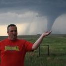
Really amazing chase day today which saw my first ever New Mexico Tornado 15 miles North of Roswell. Started in Clovis and commited west to the Supercell near Vaughn, Structure was incredible with a Stacked Plate Classic Supercell in front of us, so big nobody could fit it in their shots. Then just north of Roswell a very close Tornado across the road from us, after this I took the first golfball hailstone to the back which stung a bit from a 2nd LP Supercell. An amazing chase day which the team thouroughly enjoyed. More of the same tomorrow. Just a selection of the hundreds taken with the Tornado at the end!

- 1 reply
-
- 1
-

-
Sitting in Clovis pondering wether to play with the Caprock Magic or await some developments further along the boundary near the West Texas / New Mexico border
-
And already noting the boundary is sinking fast so will be targeting further south over the Santo Cristo mountains, will be west of Amarillo
-
Leaving Dumas in a mo, heading towards Clayton intially to hope the skies clear out for some convection over the mountains, HRRR Shows a repeat of yesterday so expecting a few severe storms and Supercells over the mountains near Capulin before more storms form ahead and slam the Panhandles later. Hoping we can get some photogenic storms today after yesterdays lousy chase
-
Chase Day 26 - Slight risk CO, KS, OK, TX
Paul Sherman replied to nsrobins's topic in Storm Chase USA
Just a fore warning, going to lose the stream in about 20 minutes time just to let you know, the Oklahoma Panhandle is notorious for zero data coverage. Hopefully it will be back tuther side when in New Mexico -
Another classic supercell. Thanks colorado
-
Starting the day in Limon and will head up towards Denver today for some expected initiation around the Denver area, rinse and repeat like yesterday we are hoping, going to take a look at the damage just to our South East in Hugo first. Paul S
-
Hi Guys yes we are going to take our chances in Eastern and NE Colorado today which places us perfecly for tomorrow as well
-
Big Big day coming up, all models all over the place at the moment, will decide in the morning and see where that warm front has meandered to, some say SD/NE Border others further south, one thing is for sure it could be a very big day with all parameters maxed out. Paul S
-
Starting in Woodward and will keep the OFB In play before we head north to probably Concordia ready for the big day tomorrow, if a storm can go up and ride the outflow boundary today could be a big bonus.
-
Reports & Pictures Chase Day 21 - Oklahoma
Paul Sherman replied to Paul Sherman's topic in Storm Chase USA
Meeting the rest of the team in Greensburg today, we are going North from Woodward and they are coming west from Wichita. Will hang back for a while before we head north just in case this outflow boundary does something spectacular today, have been burned by these before most notably on the 24th May 2008. -
Started the day in Ardmore and went south to drop the tour 2 guests off at DFW And pick up the new guys for tour 3, a quick change around and off we set at 1145am, after grabbing a lunch my target area was Woodward upto Dodge City and the plan was to roll up towards any tail end charlie storms on the dryline, what we got was another great bonus chase day and witnessed 2 Supercells, the first a Classic and the 2nd an LP Supercell. The storms took there time to structure up when they broke away from a bowing line further north over Kansas but once they did and set up in a line to our north the structure was very nice with the best mammatus of the trip so far. Some pictures from Richard of the 1st June Storms
-
Absoutely fantastic days chasing, meandered up towards Woodward and got onto a pair of stunning Supercells that just sat in front of us for about an hour, first was a Classic and the 2nd an LP Supercell, lots of gasps and oohs and aahs from the newbies who were picking their jaws up off the floor. The 2nd part of the team in Wichita overnight also got slammed by the line at their hotel so we both scored today. Pictures to follow off my Iphone tomorrow.
-
Yep Southern target for us today but would have targeted N Central Kansas today if I could have made it, so a trip back up my favourite road (NOT) The I35 Then probably at this stage towards Woodward and Dodge.
-
Yes can everyone meet with Quentin please, need you guys at Car Rentals at 11am ready for departure.
-
The next 10 days if the ECM Is to be believed will be action packed and not for the faint of heart newbie chase virgins, hope you guys are ready for this - Lol


