


NApplewhite
-
Posts
209 -
Joined
-
Last visited
Content Type
Forums
Blogs
Gallery
Events
Learn About Weather and Meteorology
Community guides
Posts posted by NApplewhite
-
-
19 minutes ago, Man With Beard said:
ECM ensembles fairly united until Saturday, but a big divergence by Sunday in southern areas with members fairly evenly spread between 22C and 35C! (raw 1pm temps) Northern areas fairly likely to see less hot conditions by Sunday.
I dont want cool conditions in Wales! Its not fair! The heat is only 100 miles away!
-
 1
1
-
-
9 hours ago, 38.7°C said:
Gfs 18z is dusting down the old blowtorch as early as Thursday now and is showing 31c for London on Thursday. As for Friday here is the chart is for 09.00 and you just know its going to be a hot day when charts at 9am are looking like these....

Massive downgrade for the hot weather for North East Wales and Cheshire its turning into just warm weather on Friday and Saturday with temperatures falling by 10c during Saturday night and Sunday daytime - from 29 down to 19. The wind direction has shifted markedly in the GFS forecasts this morning (London hangs onto the heat). No blowtorch for Wales!
-
12 minutes ago, mb018538 said:
GFS OP is a wet, cool and more unsettled outlier today:
I'd back the ECM any day and twice on a Sunday. Global Fail System has been dreadful all summer as usual.CFS Model agrees with GFS of very unsettled conditions at day 8 to day 12. Average conditions the following week.
-
1
-
-
20 minutes ago, mb018538 said:
ECM not looking great at day 8:
But much less threatening at day 10:
Doesn't look amazing - I know - but I've seen heaps worse in summer.
GFS models agree - very heavy rain over England and Wales for the period 24th July to 27th July 2020 with large precipitation amounts and suppressed temperatures.
Long range forecasts on the brilliant Accuweather (what models do they use) are indicating a very warm and dry period August 10th to August 31st 2020 across the UK.
-
1 hour ago, summer blizzard said:
GFS to day 10 is similar to recent runs.
Day 7 - Ridge begins to collapse
Day 8 - Fronts arrive in the west
Day 9 - Low Pressure firmly in control
1st August 2020 looks hot
-
21 minutes ago, summer blizzard said:
Euro and GFS essentially in agreement that next week will be somewhat similar to this week however both models show the Azores High withdrawing by day 8 and a cyclonic output thereafter.
Basically summer is over! i give up on seeing any Blue skies and hot sunshine in north east Wales this year. Time to emigrate to Australia!
-
1
-
-
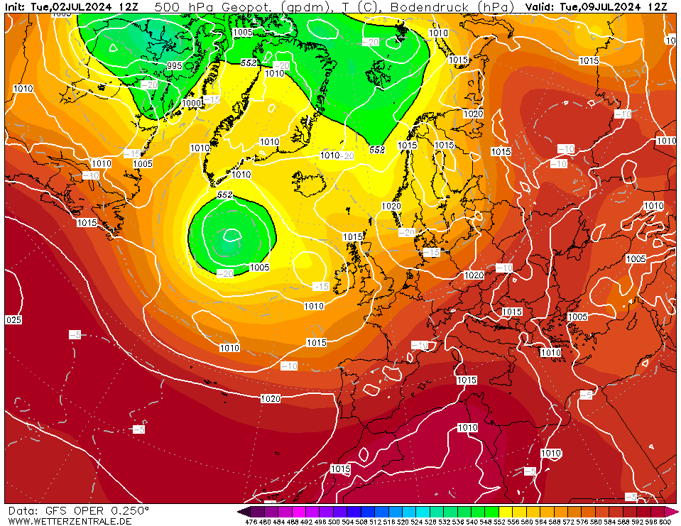
2 minutes ago, NApplewhite said:
Look at the position of the Jet Stream in 8 days time (24th July)
- shocking that its so far south (how often do you see a powerful Jet over the south of France and Balearics and Italy, Western Balkans) ? the UK, Northern France, low countries and Germany, Poland, Scandinavia are all the wrong side of the jet! only the south of Spain looks hot at the end of next week and North Africa! very disappointing
Short term its looking OK - for the first time in five days we have patches of blue over Bradley, Wrexham but its cold.
-
Look at the position of the Jet Stream in 8 days time (24th July)
- shocking that its so far south (how often do you see a powerful Jet over the south of France and Balearics and Italy, Western Balkans) ? the UK, Northern France, low countries and Germany, Poland, Scandinavia are all the wrong side of the jet! only the south of Spain looks hot at the end of next week and North Africa! very disappointing
-
Just now, mb018538 said:
It’s certainly part of the problem. Stubbornly strong easterlies all summer so far just haven’t helped us at all. This one as you say will really fire up the mid lat energy.
So my theory that the East Pacific storms will impact on a poor UK summer was correct!
-
13 hours ago, Mark wheeler said:
Ukmo 144 . No Heatwave but it certainly could be worse .
I will take this but temperatures are looking to be much lower than average - places like Leeds and manchester will struggle to reach 14-16 degrees this month.
-
- Popular Post
- Popular Post
1 hour ago, JON SNOW said:I managed to cherry pick some nice charts from the GEFS 6z and the mean looks preety decent next week..that’s it from me now..back tomoz hopefully sometime!
Cherry picking these charts isnt really helpful to meterological analysis
-
10
-
Weather is currently very unsettled across most of Europe - very unusual for July when we normally expect clear skies over Spain, Germany, France and the low countries! Could this be a later than normal European Monsoon? Azores high is very close to Western Europe - its teasing us as it never properly makes it today. NW/SE Split with the south coast of England and channel islands getting the benefit of the ridging Azores high (though the high looks to slowly retrogress and elongate). Renewed push on Monday but it brings very cool Northerly/NW winds. The Iceland low moves into Scandinavia with western parts seeing more sunshine closer to the (weak) Azores ridge. Month end is looking very unsettled as well with plenty of heavy rain to close out a miserable July in the UK. The sunshine shortage is the biggest problem this month with major shortfalls continuing.
-
2 minutes ago, Zak M said:
More cherry picking from me...
Don't cherry pick lol
-
2
-
 1
1
-
-
7 minutes ago, NApplewhite said:
Talking of Tropical systems, while what remains of what was once Tropical Storm Cristina is now in the Central Pacific, meteorologists are monitoring a new tropical depression in the East Pacific this week.
A broad area of low pressure moving off the southern coast of Mexico over the warm waters of the East Pacific Ocean developed into Tropical Depression Six-E on Monday afternoon with maximum sustained winds of 35 mph.
While this depression is expected to become more organized through the beginning of the week, there is one thing that will keep it from rapidly strengthening.
- this system is expected to encounter vertical wind shear, or the change in direction and speed of wind at increasing heights in the atmosphere. As a result, depression may be slow to gain strength over the next couple of days as the system moves away from any major landmass.
If the system continues to strengthen, it could become a named tropical storm by midweek.
The next system to reach tropical storm status, which is a system with maximum sustained winds of at least 39 mph, in the East Pacific Basin would be given the name Douglas.
Meanwhile, what remains of former Tropical Storm Cristina continues to spin farther west and has moved into the Central Pacific Basin.
Cristina weakened as it moved over cooler waters late Sunday night and was designated as a post-tropical cyclone, or remnant low, by the National Hurricane Center. Cristina initially formed late last Monday night.
Cristina became a strong tropical storm with sustained winds of 70 mph last Thursday through Friday
What remains of Cristina will not pose a direct threat to any land, but forecasters will continue to monitor the potential for impacts to the Hawaiian Islands late this week. I'm wondering what the science is around this type of tropical activity in the East Pacific on the jet stream (there is a heat dome developing over the Mid - West, Western United States) driving the Jetstream over Canada. Could this exit over the North Atlantic and increase the power of the jetstream over the next week or two? I'm interested to find out the meteorologists/scientific perspective and the impact on UK weather conditions downstream.
I've attached the latest 700 HPA wind forecasts and a snapshot of the 850s.
Lovely low pressure over the UK at +300 according to GFS!!
-
1 hour ago, Northwest NI said:
You would think these ex hurricanes coming into the mix would produce beneficial outcomes occasionally. All weather being chaotic to some extent, you’d think it would possibly sweep away poor weather just once in a while. Always seems to result in the toning down of a better outcome.
Talking of Tropical systems, while what remains of what was once Tropical Storm Cristina is now in the Central Pacific, meteorologists are monitoring a new tropical depression in the East Pacific this week.
A broad area of low pressure moving off the southern coast of Mexico over the warm waters of the East Pacific Ocean developed into Tropical Depression Six-E on Monday afternoon with maximum sustained winds of 35 mph.
While this depression is expected to become more organized through the beginning of the week, there is one thing that will keep it from rapidly strengthening.
- this system is expected to encounter vertical wind shear, or the change in direction and speed of wind at increasing heights in the atmosphere. As a result, depression may be slow to gain strength over the next couple of days as the system moves away from any major landmass.
If the system continues to strengthen, it could become a named tropical storm by midweek.
The next system to reach tropical storm status, which is a system with maximum sustained winds of at least 39 mph, in the East Pacific Basin would be given the name Douglas.
Meanwhile, what remains of former Tropical Storm Cristina continues to spin farther west and has moved into the Central Pacific Basin.
Cristina weakened as it moved over cooler waters late Sunday night and was designated as a post-tropical cyclone, or remnant low, by the National Hurricane Center. Cristina initially formed late last Monday night.
Cristina became a strong tropical storm with sustained winds of 70 mph last Thursday through Friday
What remains of Cristina will not pose a direct threat to any land, but forecasters will continue to monitor the potential for impacts to the Hawaiian Islands late this week. I'm wondering what the science is around this type of tropical activity in the East Pacific on the jet stream (there is a heat dome developing over the Mid - West, Western United States) driving the Jetstream over Canada. Could this exit over the North Atlantic and increase the power of the jetstream over the next week or two? I'm interested to find out the meteorologists/scientific perspective and the impact on UK weather conditions downstream.
I've attached the latest 700 HPA wind forecasts and a snapshot of the 850s.
-
I give up on this summer! I'm off to Rhodes for a week of blue skies and hot sunshine in August! June and July has been dire and August looking no better!
Look at the position of the high - cool NW winds off the Atlantic according to the CFS model. September looking average at best. November looks very wet and windy.
-
1
-
-
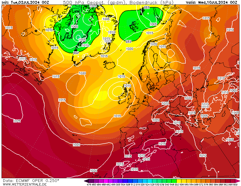
48 minutes ago, mb018538 said:
For those that discount the impact of tropical systems on forecast models - check this loop out for Friday out.
Ex Fay has been added to the mixing bowl, and as Ant Masiello states, watch how the Icelandic low depth and position keeps changing as the model changes how it resolves the impact of Fay. As it happens, the forecast from today actually has it deepest, which is in part why the weekend forecast has been toned down a notch.
ECMWF is pretty disappointing for the next 10 days. Ex Fay added to the Icelandic low will lead to unsettled conditions this weekend.
Driest and warmest in the south
Thursday and Friday should be dry and warm in most of the UK with the risk of rain becoming restricted to the north west. Temperatures in many areas will be over 21C (70F) and in the south 28C (82F) could be reached.
Through the weekend cloud and patchy outbreaks of rain steadily push southeastwards. Cooler and showery conditions follow into northern areas but there is uncertainty about the timing.
Early next week week it should be generally dry and settled weather as high pressure builds from the southwest again. Later on the the risk of showery rain increases. Plenty of Rain to look forward to on Saturday.
-
4 hours ago, Alderc said:
Close but no cigar this morning, all the models just about keep high pressure in control through days 6-7, although low pressure close to the north of Scotland may introduce a cooler pool of air and a weak northerly. In fact there's probably about the best cross agreement we've seen in weeks with this solution this morning. GEM probably the most optimistic this morning and keep some warmer uppers in for longer and temps into the high 20s for the south.
Fairly decent weather next week but no heatwave. Wet week commencing 27th July.
-
1 hour ago, Zak M said:
Indeed Mike -
With those uppers too the majority of places should exceed 20c, with the mid-twenties possible somewhere in the SE/London area
Lots of low pressure with brief ridges of high pressure throughout July
Wednesday 1 July – Sunday 5 July
The month will start with a shallow area of low pressure overhead, and several fronts in the vicinity. Wednesday and Thursday will be mostly cloudy and fresh, with patchy light rain across Northern Ireland and Scotland, and showers across many parts of Wales and England. On Thursday night, a front will push in from the Atlantic and into Northern Ireland, bringing brisk winds and rather persistent rain here into Friday morning.
Friday will be a wet day for many as the front tracks eastwards into Scotland and gradually into northern England and Wales later in the day. The exception will likely be for southeast England, where the front is unlikely to reach until Friday night, by which point the rain will become increasingly patchy. It will remain fresh and windy over the weekend.
Friday's front will linger over England and Wales on Saturday, bringing mostly cloudy skies and patches of light rain. On Sunday, an another area of low pressure will deepen as it heads in from the Atlantic and towards the northwest of the UK. Strong winds can be expected almost everywhere, but particularly for northern Scotland. There will be rain too, being more persistent and widespread for Northern Ireland and Scotland, whilst southeast England may avoid the rain entirely.
Monday 6 July – Sunday 12 July
The deep area of low pressure that will affect the UK over the preceding weekend will move away into Scandinavia on Sunday night.
This will allow a northerly flow to develop over the UK for the first few days of the week.
With cooler air feeding in from the north, it will turn fairly cool for Tuesday and Wednesday, with a scattering of light showers blowing in from the north, too.
From mid-week onwards, a few low pressures are expected to track in once more from the Atlantic, bringing some rain and breezy conditions to the UK at times through the remainder of the week.
However, these unsettled periods may be largely confined to Scotland and Northern Ireland, whilst southern parts of England and Wales may stay mainly dry.
This is because high pressure over western Europe is expected to extend into the south of the UK, forcing fronts in the north to weaken as they nudge in from the northwest.
As a result, the wettest and windiest weather is likely to be across northern areas from mid-week through to the weekend, whilst Southeast England should see some dry and calm days.
Monday 13 July – Sunday 26 July
A continuation of the previous week is expected as we head into the middle of the month, with a possible north-south split in the weather. Areas of low pressure are expected to track close to or just to the north of Scotland, and so wet and windy spells look likely across the north of the UK. Meanwhile, high pressure should still be holding some influence over the southern half of the UK. This should largely keep fronts at bay, hence allowing for mainly dry and calm conditions across southern England and Wales.
The south is also where there is the greatest chance of temperatures trending slightly above the seasonal normal. Meanwhile, in Scotland, temperatures are generally expected to be close to, or just below the seasonal norm, with banks of cloud impeding the Sun's warmth.
Deeper in July, a pattern change is expected. High pressure should build across the UK by the week of Monday 20th, and this should bring drier, calmer and warmer conditions more extensively, including to Northern Ireland and Scotland.
For those looking for another heatwave, the latter part of the month has the greater chance of seeing one. Climatologically, late-July is indeed a favourable time for hot weather in the UK. In July 2019, after a few fairly mundane weeks of weather with temperatures mainly peaking in the low 20s Celsius, late-July entertained record-breaking heat. The UK's highest temperature ever recorded was set at Cambridge Botanic Garden on 25th July 2019, with 38.7C. Though there are no tangible signs of any hot periods in July 2020 yet, late-July may be a reasonable candidate for one.
-
4
-
-
11 minutes ago, MATT
 said:
said:
Thanks for that, but you do realise you've just posted the Weather online forecast for the week ahead issued this morning by Alexi Veneros...
Enough said for Northern England and Wales!
-
On 25/06/2020 at 13:54, DeepSnow said:
Another scorcher here in Barry where I live atm, must ve around 30C, shame my weather stations back home with the parents!
Very quiet in here with the heat and thundery potential!
Heavy rain shower at 15.00 here in Wrexham on 1st July 2020
-
8 minutes ago, JON SNOW said:
Just before the 12z gets into full swing, just want to say I concur with the positive comments regarding further into July seeing a return of more summery conditions ( at times)!. If we take a look at the Ecm 0z ensemble mean it clearly shows an improving picture as next week progresses and I honestly believe we are going to see similar weather towards / during / beyond mid July as we had last week! I don’t think we are looking at an Atlantic driven damp cool squib July by any means!
-
39 minutes ago, MATT said:
Yes that looks pretty good, and it's what Brian Glaze was calling for in his extended outlook for Summer, namely a good month in August. I think Weather online are also making a similar call too, would be interesting to know what Tams makes of it... Or perhaps she may find it a little to early just yet..
CFS is very good for August with higher than normal pressure over the UK. September looks pretty good too
Mixed outlook for this week though!
During Friday outbreaks of rain push across much of the north and west. They will be heavy at times and accompanied by strong winds. There could be some rain in central counties too but much of the south and east remains dry.
Through Saturday outbreaks of rain clear southeastwards. Brighter and showery conditions follow them from the west. Temperatures remain similar to recent days. Another band of persistent rain is likely to push across northern areas overnight with showery conditions returning for Sunday. The south probably remains drier, although there could be a few showers around.
Next week is looking mixed. The south should have quite a lot of dry and warm weather. In the north it stays more unsettled with showers or longer spells of rain and at times they could push southwards.
Low pressure will continue to move east and circulate over Scandinavia on Monday 6th July 2020 allowing for ridging high pressure and drier conditions to come about for the start of the week. With that low pressure still relatively close by the northwest of the country will hang on to wetter conditions; Scotland will see outbreaks of rain, possibly heavy and persistent in that northwesterly wind in the morning, before turning more showery during the afternoon. Sunny spells with showers also expected across Northern Ireland, northwest England and northwest Wales. Drier elsewhere. Highs at 14 to 16C in the north and 18 to 21C in the south.
Tuesday 7/7/20
A largely dry day is currently forecast for Tuesday as a ridge of high pressure nudges up from the Azores. Turning cloudy across western places though through the afternoon with rain moving in to Northern Ireland and western Ireland and then western Scotland later on. Temperatures 14 to 17C in the north. Highs at around 17 to 20C in the south.
Wednesday 8/7/20
A wet day is expected for the northern half of the country; including Scotland, northern England, Wales as well as Northern Ireland and northern parts of Ireland. Further south should stay mainly dry with sunny spells. Temperatures around 16 to 19C. Cooler in the far north of Scotland with highs reaching to only 13 to 14C and warm in the southeast of England at 23C.
Thursday 9/7/20
Low pressure will clear to the east on Thursday with a brief ridge of high pressure bringing drier and brighter conditions for a short time before it clouds up again in the west in advance of the next Atlantic Low pressure. Temperatures around 16 to 20C and warmer in the southeast of England at 22C.
-
2
-
-
On 30/06/2020 at 14:12, Zak M said:
I think the GEFS perturbations are going crazy again...
What a scorcher of a perturbation p2 is though, definitely would be some thundery potential mainly for the SW. Shame it's way into the unreliable timeframe!
This perturbation looks good !
-
1
-

.png.e19f73d223086b17f3e727c9da949837.png)


Model output discussion - into July 2020
in Forecast Model Discussion
Posted · Edited by NApplewhite
Im hoping we get the heat in Wrexham! GFS showing feels like of 33 on Friday and only 19 on Saturday while London gets 35-36. Even Cardiff gets 26-27 on Saturday! its not fair! Either way it feels more than the 18 degrees showing on my thermoter! very humid and warm this evening up in Wales.