


Eagle Eye
-
Posts
7,256 -
Joined
-
Last visited
-
Days Won
42
Content Type
Forums
Blogs
Gallery
Events
Learn About Weather and Meteorology
Community guides
Posts posted by Eagle Eye
-
-
Am in Paris and tomorrow I may end up taking most of your CAPE and maybe even a Storm or two, it's always when I'm on holiday.

-
 4
4
-
-
10 hours ago, zaax said:
Sometime in the autumn the sun is so low that evaporation by the sun stops in the uk.
When is this date?It's the energy technically that causes the evaporation, hotter substances have more energy so will evaporate easier than colder substances but unless they are absolute freezing they still have some some energy and sublimation can still occur.
-
3
-
-
- Popular Post
- Popular Post
Polar-night jet oscillation, where there is an extreme warm stratospheric event that causes a SSW but doesn't cause all SSW's because of how infrequent it is, also what happens in response.
The last time one of these occurred in 2018, strong westerlies causing a strong SSW and the eventual collapsing jet stream that has reversed to easterlies falling to the surface. This is probably the best way that a SSW could occur during a westerly year. It is likely that it'll be very difficult to predict but it does show that an enhanced zonal wind in stratosphere does not mean that rapid weakening and reversing could occur and if it does occur like that you could argue it may enhance the easterlies but that's more something that should be left to the more mathematical of the members here rather than me.
Some of this was written in a PhD thesis and so I've done my best to interpret the more difficult parts:
The first thing to note is that the Arctic is plunged into night for months on end due to the misalignment of the earth's spin axis and it's orbital movement. There is therefore a big contrast in thermal heating between the mid latitudes and the Polar latitude. This means that strong westerly winds spin up. This forms over both poles in Winters and is typically called the Stratosphere Polar Vortex.
These winds are disturbed by the wave patterns known as Rossby waves. Rossby waves are typically formed by the contrast in heating, these waves can only propagate upwards in westerly winds and when they propagate into the stratosphere they can decelerate the zonal winds.
Rossby waves occur at irregular intervals and often do not move linearly, breaking up at the critical moments. Their effects mostly seem to show in SSW's. The atmosphere is mostly in local thermodynamic equilibrium (LTE) which means that locally there is very little difference in the heat dynamics in the atmosphere. The atmosphere likes to tend towards LTE and that works on a very localised levels with things such as thunderstorms and lightning.
The document then goes over the Coriolis force and it's role in Rossby waves but that is way beyond my level.
One of the more important atmospheric symmetries is the near symmetry above the rotational axis of the earth. Although there are surface disturbances, the flow tending towards the zonal mean . So for such a movement away from the mean, there is always a counter-reaction down.
Rossby waves wave speeds are easterly and so they will tend to transfer/share an easterly movement to wherever they propagate. That is one of the more fundamental parts of the Arctic Vortex's variability. Another thing to note is that Rossby waves depend on westerly flow for their propagation.
Much of the behaviour of the vortex occurs irregularly and cannot be forecast accurately in a long-term advanced notice although the chance can be worked out based on a few different variables.
Recently (ish), we began to work out that the Stratosphere can in fact affect the weather below it which can be seen by effects such as the NAM.
The lag correlations seem to suggest that the zonal wind anomalies will migrate towards the pole and then back down over several months and the temperature anomalies are in balance with the thermal wind anomalies and the zonal wind anomalies. The vortex tends to favour counter clockwise anomalies should be noted as well. Therefore the variability is stable in the Winter in that sudden dramatic effects are unfavourable most Winter's. This is the way that SSW's are recovered from so their effects can last a few weeks to a month or two in the Stratosphere although surface effects will vary based on the dynamics at the surface where the LTE is disturbed a lot more often.
The initial amplification of the anomalies are quicker than the downward movement and with this coinciding with a SSW there are significant anomalies that will take time to recover because of the unbalanced thermodynamics. This Stratospheric unbalanced is caused directly by the Rossby wave caused eastward momentum and the actual warming is caused by the rapid amplification of atmospheric waves.
There is evidence to suggest that the QBO and the phases of the solar cycle can actually affect the Polar Vortex but there's not really enough evidence for it all to be concluded and so even though the pHD goes over it I would rather not get mixed up in a scandal.
The weakening of the strong anomalies in radiative heating is helped by the process of radiative transfer. This weakening is a large scale process which is technically non-linear but it's simpler to think of it as linear. This weakening of the anomalies dissipates a lot of the wave activity usually.
PJO's occur in about 1/2 of all SSW's, they pretty much all have the same dynamical processes including in recovery. The height at which it recovers initially is where the radiative transfer begins, the lower Stratosphere taking the longest time to recover. As well as that, when a SSW reaches the tropopause there is a 'robust shift of the tropospheric jets".
Events triggered by an extended pulse of wave activity are found to coincide with PJO events so that's one thing to look for if you are looking to have a live look at the more exact dynamical recovery of the PJO over a couple months after a SSW event. An extended period of wave influence is needed for the warming to descend to the lower stratosphere and so minor SSW's can occur with a brief period of Rossby wave propagation.
Having a look at the temperature analysis at 10hpa and 30hpa, the 30hpa specifically is looking further along in high development than the 10hpa suggesting that Tropospheric waves are slowly beginning to propagate upwards but as I have discussed before we need specific setups, most commonly the Scandanavian high and Pacific troughing for a sudden warming event to occur.
Looking at it tropospherically and right now I don't think there's much chance of an extended pulse of Scandanavian ridging and Pacific troughing any time soon which is probably a good sign because we wouldn't want one too early.
The current seasonal anomalies don't really suggest anything in the way of Pacific troughing and so anything may be a brief wave interaction so despite the good blocking signals I think we may have to be relying on that blocking as any SSW that happens could end up being minor. On a positive note, it's the CFS and when is that ever correct
 ? I don't think the dynamical recovery process of the PJO will be needed this Winter though but if it is I've got this all written and I've already got to page 65 of the pHD thesis and I've got this written down in case I forget it now.
SSW frequency per decade.
The thesis then goes on about mathematical conclusions, so I've skipped out that part because I'm not the greatest mathematician.
The PJO affects tropospheric movement as said before and that would suggest that it can affect seasonal patterns and this can be used to predict a general pattern of what could happen after a PJO event and so seasonal forecasting may look more accurate if one of these events do occur although I'm not sure the seasonal models can handle the dynamical processes as well as a human with a better knowledge of maths and dynamics than me can.
The thesis does say "indeed enhanced predictability has been found following certain sudden warmings in forecasting case studies"
The lower stratosphere's warming persists for however long the recovery process of the PJO occurs, however, the upper stratosphere cools rapidly and thus forms an anomalously strong upper polar jet and in increase in vertical wind shear in the stratosphere. Eventually, as the lower stratosphere returns gradually back to normal, the cold in the stratosphere descends. This is one of the reasons that Winters with SSW's are no warmer in the stratosphere than normal Winters. Winds at that level take months to return back to normal.
As the winds recover in the lower stratosphere, the westward movement in the mesosphere increases (more specifically the drag) and slowly descends towards the bottom of the mesosphere. During the PJO recovery, the upwards velocity in the stratosphere decreases and above that the circulation in the upper stratosphere descends.
Looking at the lower stratosphere now and we know that the wave driving is suppressed in this part in the recovery phase. As well as this there is still some downward movement in the lower stratosphere so it should in theory suppress wave activity in the troposphere although the forcing downwards is weak so how much it would suppress wave activity would be down to you but that is important in considering seasonal predictions after a PJO event.
Diabatic heating plays a significant process here so let's talk about that. It is the major driving force of atmospheric circulation in the tropics which first suggests that we may see significant movement of the MJO phases as the waves cycle quicker than normal/stronger than normal because it is closely related to moisture convergence. That suggests that the troposphere may counteract the suppression with moisture activity increasing after the initial suppression and so wave activity may eventually return to normal but that could take probably somewhere between 30-90 days as a guess based of MJO cycling.
The anomalies in the low stratosphere have been shown to affect the tropospheric movement and circulation, the coupling between these two regions are actually at their strongest when weak vortex events happen followed by the PJO recovery.
This next bit is still as important as the rest as it deals with the stratospheric-tropospheric coupling which could probably have a whole book written about it.
Tropospheric jets undergo momentum fluctuations on a planetary scale. The tropospheric jet response to stratospheric coupling is strongest at 40 degrees N although the strongest stratospheric mechanisms cannot fully explain the strength of the response between tropospheric jet shifting. So it isn't entirely proved exactly how coupling feedbacks happen in terms of the mechanisms involved and it's best that I don't go into the competing theories.
The coupling of the tropospheric circulation to the stratosphere is also of interest as it may be a pathway for transmitting the influence of the stratosphere to the surface. Tropical anomalies could change the structure of the Rossby waves that cause the warming in the first place. As partly discussed earlier, the best way of the downward movement from the upper part of the stratosphere is likely found in the changing of Rossby waving.
Onto radiative damping, which is an interesting subject (I think I'm starting to sound extremely boring now), weakening radiative damping warms the stratosphere, the opposite does the opposite. Lower stratospheric warming induces a shift in the tropospheric jet and so surface winds and an enhanced vertical wind shear. The change in torques that maintains the surface winds difference is used in an upwards linear movement and so the re-coupling of the stratosphere and the troposphere completes itself and the cycle is complete and I am exhausted, this took a week to read. There is a little bit more but that's to do with the troposphere response of the stratosphere again.
I'll quote the whole of the conclusion here
"The focus of this body of work has been the identification and description of Polar-night Jet Oscillation (PJO) events, an intraseasonal mode of variability present in the Arctic polar-night jet. The statistical (Chapter 4) and dynamical (Chapters 3 and 5) behaviour of this mode has been investigated in satellite observations, reanalyses, a comprehensive chemistry-climate model, and a simplified general circulation model (Chapter 6). The main results are summarized and synthesized in the next subsection, followed by a discussion of their implications for the motivating themes mentioned at the beginning of Chapter 1. The thesis concludes with a discussion of potential future directions."
Was not sure whether to put this here or elsewhere but I've put my previous 'deep-dives' here so I'll put this here for now and let the mods decide where it is best.
-
18
-
 4
4
-
1 minute ago, JonStaples said:
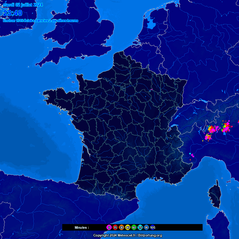
That storm in France must be quite something. The 'total strikes in last two hours' counter on blitzortung's UK map reached 76,000 at one point - I've never seen it reach that level before, in fact I'm not sure I've seen that high a count on the 'whole world' map.
Decent MCS by the looks of where the lightning is placed, would imagine some good CAPE and shearing in that kind of setup.
-
My forecast verification from yesterday.
-
8
-
-
11 minutes ago, Blessed Weather said:
Yes, not too bad a performance from Arpege. Interesting to see the development of a multi-cell line of storms in the west of the Region, as @Dami and @Mesoscale report above. From a fledgling shower at 05.45 (red circle) to an active line of storms by 07.15. For the east of the Region, I'm looking at the still developing area of rain out in the North Sea and heading into the SE corner. Might get a single cell storm or two out of that later.
Radar: 05.45:
07.15:
Yes, looks to be some enhanced MUCAPE/SB CAPE combining with a PV lobe just because of the way the convection is developing in a line over the SE. PV lobes typically move quite slow and so it may enhance development on the Eastern edge of the MCS once it hits the coast but only if the vorticity planes are connected/end up connecting. Which I admit is probably a rather confusing sentence even if you understand Potential Vorticity. Speaking of, some lightning here from the Convection but I didn't see it.
Going back to the development just North of Luton and that's probably what I was talking about earlier with CAPE ahead of the MCS and a local increase in shearing and maybe some Potential Vorticity allowing for rapid development.
-
1
-
-
@Blessed WeatherThe MCS didn't really cross the channel intact but there was some development in front of it suggesting the ARGEGE with it's CAPE on the northern edge of the MCS was the best performing model just positioned the MCS too far East.
-
Look at the movement of the system over the UK, amazing and relaxing.
-
1
-
-
Slowly building.
-
1
-
-
Storms just North of Bordeaux, first signs of the potential future MCS properly evolving, lines up pretty well with where the strongest relative vorticity fluctuations are/forecasted to be in a couple hours.

-
1
-
-
Stuff in southern France pushing North, don't know whether that'll be the MCS or not but perhaps good signs for the SE for tomorrow morning.
-
2
-
-
1 minute ago, Ben Sainsbury said:
Think you're most at risk from tomorrow morning 6am-ish.
Thanks
Time when I wake up so got an hour and a half before I get the bus, sounds like it should be fun
-
Just now, Ben Sainsbury said:
Looks like fairly widespread development from AcCas across the channel. Could be quite a thundery night later on.
Nothing much really here, sorry to say this again but I trust your judgement rather than my biased judgement, what are my chances of Storms tonight?
-
1
-
-
My risk for today and till about 10am tomorrow
Zooming in on the SE and East Anglia risk:
Quite the contrast in forecasts as @Blessed Weather says.
The UKV has quite the late arrival but a strong MCS but there is a split between Kent and the northern parts of East Anglia where nothing happens.
AROME has the most amazing October MCS possibly ever, then another one.
ARPEGE has a more northern based MCS followed by a northern flank MCS which is likely followed by moderate rain in that typical after a failed MCS look.
ICON has a less energetic MCS followed by some slightly more substantial CAPE early Friday morning.
ECM has a first MCS perhaps caused by strong potential vorticity mixing with the high theta-W values that the others either haven't picked up or it's an ECM mistake.
All in all, there's wide differences including in timing and so I'd take an umbrella with you just in case.
-
2
-
-
Interested to see what's being seen from this Storm system, possible squall line.
In fact a possible leading stratiform region by the looks of it, these occur in MCS's, favoured when the Storm relative upper-level winds are from the rear to the front of the Storm
-
3
-
-
After all of this, I'm going to Disneyland Paris on Saturday till Tuesday and hopefully I'll get a shot of lightning behind the castle

-
1
-
-
A lot of Storm potential this week based off the 15Z UKV.
Thursday morning: MCS formed likely due to an enhanced DLS and a lobe of PV I would think because we're on the Western side of it, the lightning extent is unknown.
Friday to Saturday: Likely some surface based CAPE and then some elevated Storms due to a lack of theta-W just strong enough to hold some Storms together in the diminishing low level CAPE.
And then likely some frontal rain with built in squall lines on Sunday, perhaps but it doesn't seem to be on the ECM.
-
2
-
-
Sunset of the year here in my opinion.
(One of the only times that I will take a photograph in portrait mode)
-
4
-
-
- Popular Post
- Popular Post
On 13/10/2022 at 11:25, Eagle Eye said:"RMM1 and RMM2 are mathematical methods that combine cloud amount and winds at upper and lower levels of the atmosphere to provide a measure of the strength and location of the MJO. When this index is within the centre circle the MJO is considered weak. Outside of this circle the index is stronger and will usually move in an anti-clockwise direction as the MJO moves from west to east."
Here's lots of information about RMM1 and RMM2, how they're calculated and the interpretations of the latest MJO forecasting.
The RMM's are calculated using a combination of different functions to do with outgoing longwave radiation (OLR) values onto a spacial patterns based off the MJO characteristics (the way that it's graphed). The MJO convective patterns can be captured using the OLR values because it's a proxy (substitute) for convection. As well as that, zonal winds in the upper and lower part of the Troposphere, an increase in zonal wind activity and amplification means that the oscillating pattern has likely reached that area. OLR values are realtime but zonal winds do run a few days behind so RMM values may be slightly off. There is then a removal of the ENSO in this calculation because the values associated with the La Nina/El Nino patterns resemble that of the MJO and so the removal of SST values is introduced into the RMM values. The mean of the last 120 days is also subtracted to make sure that the ENSO does not make any change to the MJO positioning.
The variation in RMM1 values frequency, you can see the typical 30-80 day patterns in where they are associated (sometimes quoted as 30-90 days).
As well as RMM2.
An analysis from 1974 to 2003 of the MJO positioning, you can see the typical movement in terms of being in the weaker values with phases 5-8 looking to be the most common when the MJO is out of the weaker values.
The lag between RMM1 and RMM2
Seemingly, the only difference between RMM1 and RMM2 are the height of the Troposphere. One is at the entry and the other at the ceiling of the troposphere from what I understand. If that is true then RMM1 is likely as it enters the Troposphere and RMM2 at the ceiling of the Troposphere because that makes the most sense.
So how do we calculate amplification.
It's not as difficult as you would think:
When you think of it like that it makes sense, it makes the RMM a 3D model by squaring the values but the square root of them together calculates the difference between their (OLR and zonal wind) values at different heights to work out how much forcing there is specifically in the troposphere as created by the MJO.
The amplification of the MJO and it's forcing for Tropospheric waves is reaching similar values to what you would expect going into late Autumn/early Winter so we're in a similar period to last year but we've entered slightly earlier, perhaps giving time for blocking to occur so we may have a better Winter if the amplification lasts and we get lucky with the positioning of blocking, either Greenland or Scandinavian blocking. If there's enough vertical propagation then a SSW may occur as I have said previously but whether we'll get the Pacific toughing is a big question and minor SSW's are possible that have little effect on surface conditions so there are 'drawbacks' as such. We could of course get stuck under blocking high's so that's another 'drawback', this sort of pattern is a 25% success rate I would say. So don't act too surprised if nothing happens majorly this Winter, we're sort of clutching at 4 straws and only 1 of them is going to be what we want.
The MJO is currently somewhere between phase 6 and 7 with forecasts going towards phases 7 and 8.
So what happens in those phases?
Not really much difference in terms of NAO so don't expect major changes towards cold but apart from that there's not much that can be expected except maybe some blocking if I had to hazard a guess.
The RMet's has a section on this based off change of NAO regime.
So, what will we be looking for over the Winter, here's the figures:
"In the observational data, the lag 0 NAO+ response to MJO phase 3 is zero (i.e. climatological probability of observing NAO+). After approximately one week, the probability of occurrence of NAO+ rises by more 30%, implying predictability of entering an NAO+ regime. However, in the model, the chances of experiencing an NAO+ event are approximately constant from lag 0 onwards, at 20% higher than the climatological mean."
"There is a strong NAO− response to MJO phase 6 in the observational data. In this case, the response peaks approximately two weeks after phase 6 and exhibits a 47% increase in NAO− occurrence, suggesting phase 6 as a precursor to an NAO− event."There's quite a lot to read there but it does hopefully set you up on what to look for in the MJO this Winter as a -NAO event is what we would want for a colder pattern.
Next time(?) I'll likely be talking about certain Arctic oscillations to look out for but some of them are more low frequency events that are more to look out for in your peripheral vision because they're even less frequent than SSW's.
-
6
-
7
-
Later on this week, Wednesday night and there looks to be some significant WAA(Warm Air Advection) pushing up energy from the South (varying amounts on the models but most seem to have at least some) due to a widespread advection of theta-W values well into the 14's. There looks to be some CIN but too little to avoid the whole event and also some DLS (Deep-Layer Shear) so even the models with low CAPE values, there should be enough shearing to help with height and longevity of any Storms as well as organisation into an MCS or a squall line. There's not much tilting to the trough so any extra kick by a negatively trough is unlikely at this time but there is a plane of relative vorticity that should help with initiation so as long as there is some CAPE there, something should be created if the rest goes to plan.
-
3
-
-
Summer 2022 was the warmest on record according to the C3S climate bulletin (for Europe at least)
"The average surface air temperature over the continent for the months of June, July and August was 0.4°C above the record set by the summer 2021."
-
3
-
2
-
-
- Popular Post
- Popular Post
The anomalies are about to properly leave Phase 5 over the Maritime continent and we can see the RMM values are expected to increase as they enter phase 6 specifically based off most models so it's still relatively weak at the moment. You can see the anomalies sort of moving Northeastwards as well as increasing their wave output in the latest GFS run.
Here's the MJO forecast (and history) from most major models' recent updates.
Here's the amplitude at the moment, you can see it increasing quite quickly, I suspect that it'll be nearer the top end of the graph based off RMM1 and RMM2 forecasting, specifically RMM1 is near the top end of the forecasts.
Here's a little help on understanding what RMM is, I will talk more about it soon, have found a document about it as well as other associations with it but will take me a while.
"RMM1 and RMM2 are mathematical methods that combine cloud amount and winds at upper and lower levels of the atmosphere to provide a measure of the strength and location of the MJO. When this index is within the centre circle the MJO is considered weak. Outside of this circle the index is stronger and will usually move in an anti-clockwise direction as the MJO moves from west to east."
-
10
-
29 minutes ago, RainAllNight said:
Just for fun I've had a look through charts for the same day in previous years to see if there's been anything similar in my lifetime to what's being forecast for next week, and 2001 stands out as being quite remarkably similar, and according to Google this was the third of three consecutive La Niña years, just like this year. In recent years, 2020 (also La Niña) looks the most similar, although it lacks the joined-up heights to the north.
2001 was in fact a triple dip La Nina however it didn't carry on over the Winter, it went into Neutral from the summer onwards.
Arguably, the year could be unlike others and there's so much difference in the seasonals anything could happen.
-
5
-
-
3 minutes ago, Ed Stone said:
And, as both myself and others have repeatedly pointed out, temps in mid-October 1978 were close to 25C: IMO, weather in September (1973), October (1974), November (1988) has little if any effect on the following winter?

You could make the argument that it does but it's indirectly and is a very low correlation. Essentially, anything can still happen this Winter because we've still got months left and patterns change quickly usually in a La Nina year.
-
3
-


.png.f82dfc8cc2dac4df317eec5e99d3115a.png)

.png.6ad89b88685f31505b5a56460b8372ef.png)
.png.6281386a0aff68c73c5dbfa347b5f533.png)
.png.6dec7389132fa85045de086060328be9.png)
.png.40a30fce4475919caecc70692e9cbbbb.png)


Model Output Discussion - Autumn arrives
in Forecast Model Discussion
Posted
Well, after that 180 page document summarised, I'm getting my friend Olivis to pick between a choice of 3 docuemnts every week for the next 3 years and I will summarise each document by the end of each week, so by the end of the 3 years when including holidays I should have read nearly 150 documents on Meteorology by the time I'm hopefully starting university. Don't worry, I haven't made her do it she was genuinely up for doing it, she loves learning and helping others learn more than I do although she's more of a mathematician (maybe I should ask her to do the mathematical stuff in the future) than a Meteorologist.
In the meanwhile, the effect on the enhanced wave activity propagating northwards from the tropics is being felt in the Rossby action of the atmosphere and that could likely mean that blocking persists for a while although beyond that with enough upwards forcing the NAO may be reversed by the eastward forcing on the Rossby Waves but you can get different areas of the bases of the NAO and so I wouldn't be willing to call it.