


Paul_1978
-
Posts
1,454 -
Joined
-
Last visited
Content Type
Forums
Blogs
Gallery
Events
Learn About Weather and Meteorology
Community guides
Posts posted by Paul_1978
-
-
Well what I'm taking from the GFS so far this morning is that is that it's going to be a week of fluctuations. The snow line will be in various places across the country over the week - there will be cold periods with snow, and less cold periods with rain. For those who like snow, we will get some; for those who don't you'll get your less cold spells with rain.
Overall an interesting week ahead and that's why we're all here because we love the weather.
Personally I'll have to keep watching the forecast as I am supposed to be in London on Wednesday, travelling down from Yorkshire and back again later in the day. Could be a bit dodgy... we shall see!
-
 3
3
-
-
- Popular Post
56 minutes ago, sunnijim said:I don't say this lightly ( and we have been here before with charts on the perifery of and within FI) that haven't verified anything like shown) but...
This would be a March spell for the history books talked of in the same breath as 47 and 63, with the key to the historic nature it being March of course.
If we can get a couple of weeks out of the situation as shown.
Come on now.....
-
11
-
40 minutes ago, RainAllNight said:
The coldest day currently showing up within the more reliable timeframe is next Tuesday, with the UKMO having found the lowest 2m temps for this day.

4C-6C in Yorkshire is just a chilly day, not particularly cold. A way to go for the really cold weather people are looking for.
-
4
-
-
30 minutes ago, Cloud 10 said:
18z sticking to the script so far.
Doesn’t look cold at face value, and in fact rather dry too.
Good synoptics, so we’ll see if we can get some cold as we enter March.
-
3 hours ago, Met4Cast said:
The 06z det is a very clear outlier unfortunately, 0 support from it’s ensemble suite.
"A clear outlier".......but only for 24 hours...?
Very tightly packed from 17th to 24th Feb.
-
2
-
-
Having enjoyed the almost spring-like weather recently, I for one am not particularly looking forward to any upcoming colder weather. I love snow but would have preferred it in Dec and Jan, not as we are about to enter March!
-
3
-
 1
1
-
-
1 minute ago, mushymanrob said:
Whats a QTR?...
tiaQuick Trop Response
-
2
-
 2
2
-
-
48 minutes ago, Johnp said:
Oh dear - a much flatter 18z run so far up to day 8.
Nothing interesting has been on the cards before day 8 on any model anyway. GFS turning out alright in the end. We need to reel these decent charts in with a rod and line!
-
4
-
-
This may have already been mentioned, apologies if it has. Marco from the Met Office tweeted that if a warming does occur then it is expected to have no impact on our weather as the strat and trop are not coupled.
Original post: https://community.netweather.tv/topic/98196-model-output-discussion-new-year-and-beyond/?do=findComment&comment=4796251 -
57 minutes ago, frosty ground said:
What you have written and what the tweet states are not the same.
have you missed a tweet?
It’s the second tweet down - for some reason copying the link has quoted both the first and the second.
-
3
-
-
This may have already been mentioned, apologies if it has. Marco from the Met Office tweeted that if a warming does occur then it is expected to have no impact on our weather as the strat and trop are not coupled.
-
1
-
4
-
4
-
-
2 hours ago, Bricriu said:
The thing is the ECM chart is what you might expect to see before the consequences of a SSW or something close to one are seen in the Troposphere. Although the fact the UKMO long range still makes no reference to blocking is concerning. If Glosea saw a strong signal up in the strat for a SSW you would think the texted forecast would make some mention of it. The video forecast yesterday would also suggest their model sees it as unlikely.
Yesterday's video suggested there was a 25% chance of an SSW (obviously as things stood on 18/01), but the picture may have changed/improved today? I don't think the MO's text forecasts would change until the probability is higher, and as we know an SSW is not a guarantee of anything anyway, In fact it probably makes things even more complicated than normal when it comes for forecasting

-
1
-
1
-
-
- Popular Post
29 minutes ago, northwestsnow said:Yup.
Basically the Atlantic wins.
Don’t keep being so negative mate. With a possible impending SSW, all bets are off as far as I’m concerned.
-
8
-
2
-
This thread is extraordinarily quiet given what is potentially in the offing, so here is a Tweet to get the discussion going.
-
3
-
1
-
3
-
-
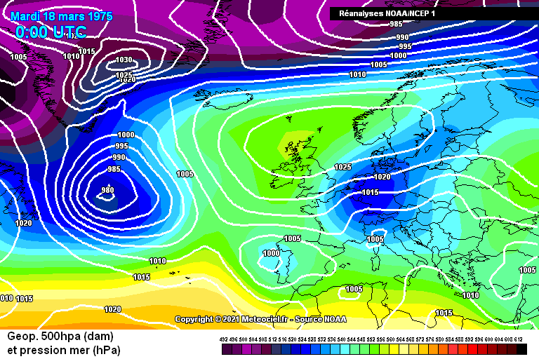
Funnily enough I have just been running through the charts from Dec 1974, Jan to March 1975. I noticed that the weather was predominantly westerly from Dec to Feb and then all of a sudden a cold March came out of nowhere but not until around the 10th:
18th March looks bitterly cold too, with a low pushing up from France by 20th.
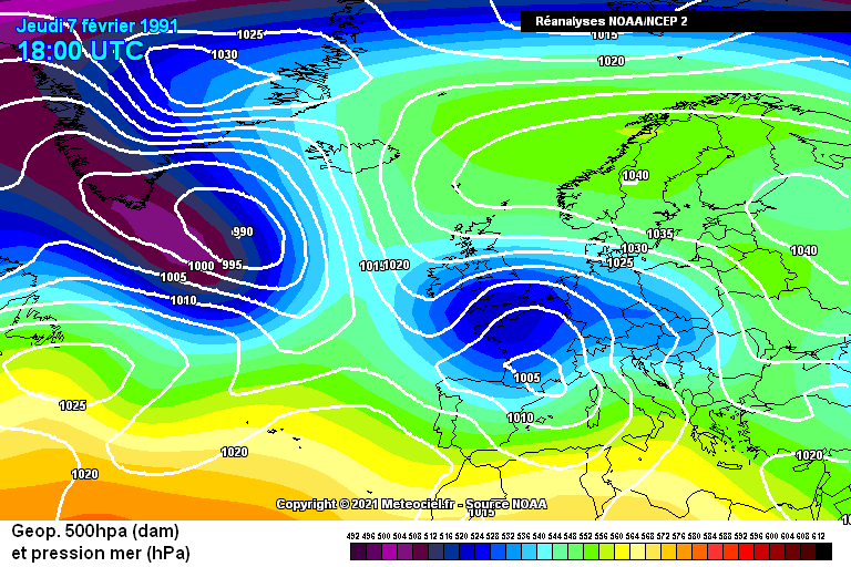
....the last chart perhaps being similar to one of the famous Feb 1991 charts:
So whilst the winter of 1974/75 seemed generally mild, it certainly went out with a bang.
Would be interested to hear of anyone else's memories of March 1975.
-
Great post - a little known event not talked about very often. Cheers!
-
21 hours ago, Drifter said:
Crikey

See you in Feb.
I genuinely hope that is tongue in cheek in you’re literally not writing off the rest of winter!!

-
-
A bizarre 18z GFS. Pretty much the same low pressure system stuck in the Atlantic for 200 hours. I’m not buying that!
-
3
-
1
-
-
3 hours ago, Frank Trough said:
Reservoir levels are still low though, so rain is much needed. Fine balance though between wanting to fill reservoirs and not wanting issues with flooding.
(ps great username)

-
6
-
-
16 minutes ago, Lukesluckybunch said:
It's too far out though..to take seriously this 18z never got going tbh
I genuinely don’t know which 18z run you’re looking at as this is another great GFS run on the whole that we’d have all given our right arms for in November!
-
9
-
-
12z GFS is turning into one of the great runs of all time! Coupled with today's MO update, let's hope it is onto something, but there's a big divergence amongst the models at the minute.
But hey, this is why we all love model watching right? The next chase is on!
-
3
-
-
2 hours ago, Mucka said:
Icon and GEM are cannon fodder and more likely to confuse than enlighten.
No they are not. Don’t forget Ian Fergusson’s recent tweet which suggested he rated ICON and GEM more than the GFS!
-
1
-
-
9 minutes ago, Met4Cast said:
The AAM has as expected fallen through the floor with a further strong -MT event & signs of westerly momentum returning to the mid-high lats. The UK likely to be on the boundary between cold/mild with snow possible (mostly in the N) before milder air eventually wins out. i.e any colder periods for the remainder of this year are likely to be transient affairs but may still produce snowfall for many.
MJO prediction suggests renewed Greenland blocking end of 1st > 2nd week of Jan but my current thinking is it'll be more west based, i.e UK remains milder with probably low pressure sat over the UK rather than being forced to the south like this current cold spell.
Had the MJO cycled around into these phases during the second half of this month like early forecasts had suggested things would be very different, but the timing is off to support prolonged cold into the UK and of course is only one aspect of the global budget.
To add to the above.. the trop led running of things may be on borrowed time with signs of the stronger u-winds descending down from the stratosphere. SPV possibly setting up shop over Greenland again. Cold lovers *perhaps* living on borrowed time now.
No signs of an SSW in the forecast nor any sign of an SSW precursor pattern appearing on the outputs. Unfortunately I'm growing more & more confident that an SSW is unlikely this year, or at least in the next 3-4 weeks.
So.. transient periods of colder weather but the trajectory does appear to be increasingly towards a milder one for the UK. Indeed, GLOSEA suggests westerly winds becoming more dominent as January progresses, fitting well with the above background signals.
Well that isn’t what we wanted to hear.
Seems at odds with Matt Hugo’s thoughts earlier though unless I am misinterpreting?
Edit: Matt’s post was focused on Christmas and New Year - you’re looking much further ahead.


Model Output Discussion - A cold start to Spring?
in Forecast Model Discussion
Posted
Jeez that doesn't bode well for my train journey from London back up to Yorkshire at 5.30pm tomorrow.
As regards the GFS 6z, it looks like it's going to remain cold to Saturday, perhaps a slight warm up on Sunday but with the cold digging back in by Monday as the next low passes through..