


snowbunting
-
Posts
268 -
Joined
-
Last visited
Content Type
Forums
Blogs
Gallery
Events
Learn About Weather and Meteorology
Community guides
Posts posted by snowbunting
-
-
4 minutes ago, Man With Beard said:
ECM monthly D15-D21, claims the Atlantic will be back. At odds with sounds coming out of the METO.

The ECM cant even get D7-D14 right. Nope reckon blocking in some form or another in charge rest of Feb.
-
 2
2
-
-
30 minutes ago, Snipper said:
Don't be nasty about my wife.
You wish☺
-
2 hours ago, Seasonality said:
Some Monday morning cheer. SCORCHIO!!!!
That cannot be deemed sexy. That just looks weird. Too many nights at the computer for some of you lads. Perhaps too much weather porn!
-
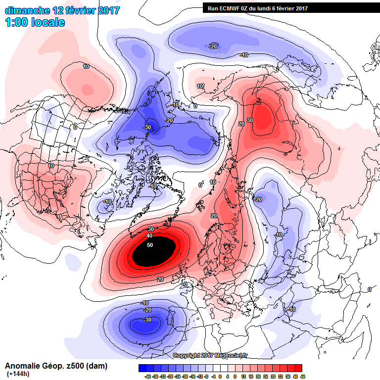
1 minute ago, Weather-history said:
ECM 500hpa anomaly chart. at 144hrs
Thats one monster of a block. Dry and cold and sunny for us in the Western Isle for a long time. March will be interesting.
-
2
-
-
4 minutes ago, blizzard81 said:
Mmm, that retched Azores high determined to be mischievous again. However, Tamara seemed certain in her post earlier today that the Azores high would not scupper this one. Squeaky bum time indeed lol.
Missed that post, now hunting for it.
-
Long range that looks a monster area of High pressure in the Atlantic. Anyone for an early spring?
-
1
-
-
5 minutes ago, feb1991blizzard said:
Doesn't look an outlier to me, it looks the same as the mean more or less.
Agreed. Was looking at the charts, I think a scandi high bringing a brief easterly then settling into high pressure centred over the North of the UK would not be unreasonable, if following the ECM. Repeat 2013?
-
4.0C for me please
-
When you see powerful atlantic storms turning westwards again. You must think... hang on?
-
2
-
-
no this is far more interesting!
-
2 hours ago, Gray-Wolf said:
Does it open the door for tropical air incursions to the north?
Oh Gray Wolf. The possibility of summer for the western isles!!
-
3
-
-
Good find Knocker! What if a wavy jetsream became so wavy that it suddenly and abruptly dissapated?
-
Wow.. where did that warming come from? That appeared out of slight warming. Given the timescale it has made an appearance at. Little wonder the models are chopping and changing.
-
1
-
-
There we have it. First tentative signs of a Nly airflow. Induced from a Greenie High. Think it is best to look at the NAO going negative on the emsembles. It is way out on the run, but supports my hunch. Sorry guys. Gut instinct rules with me much of the time.
-
13 minutes ago, KTtom said:
I cant believe some on this thread are still hanging their hopes on high pressure to the East? One thing that has been solid consistency in the models and the Met is deep trough to the west of the UK...untill that high pressure relents to the east we will be stuck in milder air, we desperately need the troughs to clear east to give us a chance of a pm incursion...gfs tries it's best..easterly, no chance.
I think its going to come from a Nly blast and Greenie high extending down.
-
2
-
-
Our high level stratospheric cloud today. Shortly after this the main part went and oily pearl white. Extremely high up. The sun rising was another 45minutes away.
This is the part that gets me. Last time we had conditions like this was Dec 2012, Jan we had a spate of SSW. Very cold spring
Feb2006... the same very cold spring
Feb1996 the same. Very cold spring.
So why should this be no different. I dont buy into a full blown atlantic driven pattern. It doesnt feel condusive to what we have seen with lows shooting northwards to svalvbard.
-
Just now, mb018538 said:
Erm, are we looking at the same charts here?? Looks pretty Atlantic dominated to me!
Ensembles also have no cold members, and plenty of ppn throughout. Unsettled.Personally think it will take another stratospheric warming over the poles to weaken the strength of the PV. I noticed on the second last chart just how sausage like the PV is forecast to be. Another warming event will almost certainly split that... then the fun and games could begin. I have no idea how close we are to a reversal of the QBO... its overdue.. and Im still trying to work out where the MJO fits into this as well! Given how dry and non typical this winter has been so far I wouldnt be surprised if we see something special late winter. Show isnt over!
-
5.1 please. Think feb will start of atlantic dominated then effects of SSW will begin to show their hand.
-
1
-
-
56 minutes ago, Kentish Man said:
Now the ECM has gone on full on mild mode perhaps cold fans should be more hopeful given the overrated model has spent most of this winter predicting cold spells that have not materialised.
Hmmm that nly blast was pretty severe though. Winds were very strong and blowing in Graupel and thundersnow. I personally think the GFS and ECM got it right. A brief Nly followed on by a toppler high pressure. The easterly was grasping at straws. If you want an easterly wait till feb. The coldest part of our winter isnt here yet.
-
59 minutes ago, MP-R said:
I seem to remember a brief return to zonality in mid-February 2006, only for 3-4 days between the cold first half and the easterly in the second half. The models might be showing something similar with time, if zonality returns at all (which is still doubtful). If a scenario does play out like that, I just hope the easterly has 10 times more punch than the Feb 2006 one which was just grey and cold. The serious cold and snow didn't really arrive until the winds swerved northerly.
It was march 06 that turned really brutal. Most snow I had seen for years. Recorded 17 days of snow lying.
-
12 minutes ago, markyo said:
Old Ma Nature usually addresses the balance in the UK,a dry hot summer would most certainly not be good at all,levels are low,wildlife suffers,fingers crossed for a natural re balance. I know many yearn for those high temps but it's like those seeking really low temps in winter,they both hurt and destroy the countryside,i was around in 76,that was a killer without any doubt.
Think a repeat of 2013 for feb and march is on the cards. Time before that was spring 2006. 1984 produced similar synoptics. 1984 and2006 were long warm summers. I expect the same this year if for no other reason than being overdue.
-
The mild warmth just before this baby lands a punch. If Im not mistaken that is a SSW. The GFS is really good at predicting them long range. Long term blocking I wouldnt bet against now. Feb looks very very interesting. It is to forget the cold blob in the atlantic ocean. But from my untrained eyes it seems to be where alot of the high pressures increase from.
-
The hunt continues that easterly was always going to be grasping at straws. You might want to draw your attention to another nly outbreak in 9 days time as the PV finally moves out of Canada. Ive seen it a few times now and the NAO forecasts would support it. The ensembles support that kind of setup too albeit slightly different times.
-
1
-
-
On the topic of reminicing about times gone by. It has been a long long time since we had proper blizzard conditions. But on Lewis that is exactly what we have tight now. It is defo snowing though rainfall radar shows sleet. Meto forecasted snow shower then sleet. So much colder than forecasted. Presently have 2 inches of snow on ground. 50mph gusts... more snow falling. Proper little blizzard. Here is hoping that occluded front doesnt have too a warm an upper.


Model output discussion 25th Jan - The final third of winter beckons..
in Forecast Model Discussion
Posted
I can see the high pressure to the north evolvong sending down a very potent nly blast +240hrs.