
- Popular Post


gottolovethisweather
-
Posts
7,850 -
Joined
-
Last visited
Content Type
Forums
Blogs
Gallery
Events
Learn About Weather and Meteorology
Community guides
Posts posted by gottolovethisweather
-
-
3 minutes ago, Ben Sainsbury said:
GFS 12z looking much better on this run. You can see the high sitting further west over the Atlantic. Amplication better too as stretching up to Greenland. As the high has a better tilt the winds sit more NE than E bringing the risk of snow showers, possibly colder too. Good consistency I must admit.
12z at 168hr:

6z at 174hr:
I must say, that is an absolute perfect placement of the High-Pressure cell there too, couldn't have drawn a more perfect chart for the start of a new weather year. If such charts are still being predicted in a couple of days henceforth I'll be very interested, just not getting too excited yet.
-
 4
4
-
-
11 minutes ago, Steve Murr said:
Snow showers moving SW across the UK as the colder air digs...
What timeframe is that Steve?
-
2
-
-
On 21/12/2016 at 13:00, gottolovethisweather said:
Yes indeed Legritter, I think some cold days ahead as we close out the year, a tad deja vu, but I'm not bothered, dry, frosty by night, chance of ice days all suggest it'll be fantastic for walks out in the countryside.
1BUMP.
Not that I've followed the outputs of late as I've been otherwise engaged but it seems five days on, most predictions are still on course for a rather cold end to this year and potentially and even colder beginning to the new one. Glad to witness plenty of consistency in the modelling (based on other folk's analysis of it) as there often is when HP is ruling the roost somewhere nearby.
Get outside and enjoy the beautiful weather away from parts NW while you can, people.
-
1
-
-
Well, the future must be bright given some of the outputs of late and the fact that the sun even came out briefly here in Newbury, complete with seasonal drizzle, so a kind of a drizzly sunshine, lol. If any the films I've watched of late verify, it'll be an interesting end to 20-16 and beginning of 2017.
If only? One never knows.
Have a great day, all.
Best Wishes
gottolovethisweather
-
3
-
-
33 minutes ago, stewfox said:
Need to close that net
Blocked to the East of us, Blocked to the West, Stuck in the middle with nothingness.
Deuce points.
-
5
-
-
34 minutes ago, Ed Stone said:
And, just in case anyone had thought I'd exhausted my supply of pathetic tennis-related metaphors, Mr GFS has just sent a potentially match-winning backhand drive-volley right between the tramlines!
I've got one question for you then, Pete. Will it snow in Wimbledon?
-
5
-
-
10 minutes ago, swfc said:
so moving into the early part of jan there maybe some mlb??? wow how far can this bar be lowered when frost causes orgasmic comments!!!.guess its better than rain but really looking at the ever present heighths to the south whats to like
Orgasms aside, it is all weather-related discussion.
Any pictures or the orgasm didn't happen? Second thoughts I'm off to the watch the ECM unravel.
-
4
-
-
41 minutes ago, booferking said:
Im with MS on this one that high pressure is a right pain in the backside
Winter is about snow you can get frost in Autumn,spring even summer sometimes it not very hard to get frost, Winter is about snow
2Errr, nope.
Winter is about a possible record-breakingly mild and pretty darn breezy Christmas day. Welcome to 2016.
What of 2017? All the mildies might be screaming If only it could last and people wouldn't get their runny noses and frostbitten fingers and toes. I say be careful what they wish for, post-Boxing Day and onwards it might get quite nippy by day and night with stubborn fog returning instead of stubborn Jetstream drove depressions hurling themselves towards parts North and Northwest UK.
All to play for by then, but primarily mild, damp and gloomy at times and very windy beforehand. The snow will return, it simply feels like an age before it ever does so that when it does arrive, REVEL IN IT! Make snow angels, run around naked in it, take videos, photos, the lot, its getting rarer in the UK for sure. Who knows whether my mate or my niece's kids will ever witness deep snow cover away from the highest hills in future, one can hope they will in this climate of extremes of ours, for now, I might send them on a one-dayer to the Sahara lol. We have to laugh otherwise, we'd all cry.
-
7
-
-
11 minutes ago, Snowmut said:Don't worry Bing's got this covered aswell!!
It will snow again,there will be grit shortages,impassable roads,school,airport closures,etc etc....but when,we don't know..but everyday is a day closer!!
Merry Xmas
What have I started, lol. YouTube videos everywhere.
Quietly yet quickly attempts to dig out a blocked scenario development, this from the overnight ECM 0z at t+168 hours (28th December).
A doodle showing the hoped for "stuck in the middle with you" blocked scenario, not one that is currently on the cards, but COULD yet develop as the NWP outputs play about with all such possibilities over the coming days.
-
3
-
-
29 minutes ago, legritter said:
Must be very hard to say what the synoptic situation will be come early January, at ten days away that's ages in meteorological time .Also bearing in mind that the upper atmosphere at this moment could be cooking something up ,even in this modern day the amount of data collected is minimal even with sattelite and computers ,our only hope from current pattern is time IF you want some magical white stuff and ice days , looking very likely that the Atlantic could slow down so let's hope any high pressure can establish in the right position ,another straw clutch for me is the fact that the euro slug as been king for a while ,let's hope a new king comes to power , thanks to Fergie weather for his input into our top weather forum ,cheers
.
Yes indeed Legritter, I think some cold days ahead as we close out the year, a tad deja vu, but I'm not bothered, dry, frosty by night, chance of ice days all suggest it'll be fantastic for walks out in the countryside.
-
8
-
-
1 hour ago, fergieweather said:
Latest DECIDER products lean to increased risk of NW'ly flow early into New Year; equal chances of high cell being centred over France or W of Ireland by that stage.
So in other words, BLOCKED to the West of us, BLOCKED to the East of us, STUCK IN THE MIDDLE OF YOU.
Wow, a song from the year I was born. Happy Christmas everyone. I quite like the battleground atmospheric stagnation in the model outputs post-Christmas because it makes us deliberate what might come about as we enter the New Year, something we'll be debating over for days no doubt.
-
6
-
-
4 hours ago, Banbury said:
Chilly not cold I said but too be fair below the average for most of the UK
I personally don't understand all the debate over whether something is cold or cool or balmy as to me it's all barmy and doesn't do much to assist confused or those less-experienced in model reading. But today was cold in Newbury, Berkshire today with a 5.5c Maximum at midnight and a daytime high of 4.4c; that's cold enough for wintriness given the right parameters. As for the upcoming days, it is suggested the big day itself will be mild, but even that could change right now, aside from the more cool rPM air than anything else with the briefest warm sectors in between. Come, Boxing Day into the turn of the year, it may well become more settled and more appropriately less STORMY, not that the South should see much in the way of rain or gales, bar tomorrow if current expectations go to plan.
-
1
-
-
52 minutes ago, igloo said:
you mean the best of a bad bunch still way better than the billions spent on LRF
Ah, we should all realise that we can second guess the weather, just as we cannot second guess Mother Nature. Much respect to those who put their collective heads above the parapet, though, at least it always gives us something to whine about, lol.
-
1
-
-
6 minutes ago, mulzy said:
It's still the gold standard!
Always is, always will be.
-
31 minutes ago, Summer Sun said:
As you were really high pressure to the SE low pressure to the NW leaving the UK in a southwesterly flow
Pleasant enough in any sunshine but always the chance of stubborn fog where / if skies clear then frosts would return
I don't mind a bit of stubborn fog, tends to make things feel more seasonal and can't often keep things chilly. It's the stubborn heights over Europe and due south of us I don't want in winter and those stubborn jet stream disturbances. Off to hunt darts action now, not chart action.
-
16 minutes ago, West is Best said:
The Bartlett High
I don't trust the ECM at the moment. It has been so wayward. It's only finally picking up on the Christmas Eve low.
It sure does seem to struggle post D5 from what I've scrutinised of late, but I tend to only follow the 12zs of all NWP outputs and compare daily, which seems to provide more consistency in terms of understanding their evolution.
-
1
-
-
49 minutes ago, phil nw. said:
Just looking at the coming few days and a real pickup in the Atlantic jet is already showing it's hand upstream with the first shot of colder air hitting Scotland by Wednesday.Rain with strong to gale westerlies and quite extensive snowfall for the Highland region by the looks.
These unsettled conditions then extending south through the week. We can see on the gfs for Friday the 2 lows one close to north west Scotland and the next one due to arrive Christmas day just leaving Newfoundland-just look at the strong jet all the way across fed by cold flow off the Arctic Canadian/Greenland area coming south into the milder Atlantic air.
During the transient spells of polar air it will feel quite chilly everywhere with snowfall showing up across higher ground in Scotland and some other northern areas from time to time.
A very mobile pattern at least until beyond Christmas is now looking odds on with severe weather warnings quite likely for gales from those 2 lows as we get closer to the time.
6Thanks as ever Phil Nw for your input. As others might have missed my post as it lurks at the bottom of the previous page, I'll link to it below. I concur with all that Phil states above. The Jet is about to get big time FIRED UP!
-
On 16/12/2016 at 10:41, gottolovethisweather said:
That's some serious depth of cold out towards Greenland but will it ever leave their shores. I cannot convince myself to look past the 21st/22nd December right now, but I have a feeling the period immediately around Christmas Day and towards the close of the year will be a memorable one. Everything but the kitchen sink springs to mind, so yes I favour an active period! Snow for some too with not everyone joining in the fun and a lot of transient stuff.
Three days on and we can now approach the festive period with a higher degree of confidence in the forecast.
A significant (memorable?) period of active zonality and not your typical SW'rly type is set to besiege vast areas of the United Kingdom during the festive period. In particular, if I were living in the Northern extremities I would be preparing myself for that "everything but the kitchen sink" reference above. As for the specifics nearer the time stick with the local forecasts and media updates as I think these next ten to twelve days will start getting a lot of media attention. We needn't be fearing for our lives here, but we do need to use a lot of common sense when making travel plans, etc., etc. This prediction of forecast conditions could easily get downgraded in time, but equally, with a ferocious Jet Stream going bananas spinning depressions towards the UK (Tomasz's words not mine) I would at least, keep tuned. Nothing overly mild except brief spells of WAA ridging between the lows, temporary periods of wintry precipitation are on the cards too. Cool to average, little chance for frosts and sustained dry weather, in other words, UNSETTLED being the key phrase to describe our upcoming weather pattern.
Down IMBY it might not be much worth writing home about but matters not to me, there is much going on elsewhere for me and others to focus on. TAKE CARE.
Let's see what tonight's ECM makes of the next few days now.
-
1
-
-
10 minutes ago, IDO said:
No. It was based on looking at the ensembles that are tending by D10 to suggest the mini ridge/trough combo is in a good cluster and as GEM and ECM ops are in that ball park I drew the conclusion that the GFS was overplaying the Atlantic zonal flow (a regular occurrence):
2Can you please clarify your future posts with the timescales you are referring to, otherwise we end up with a lot of posts like this very one, querying what you mean.
IDO, you are not alone in this as plenty of other folk do the same , anyway........ Onwards and upwards. Enjoy your evening, people.
-
2
-
-
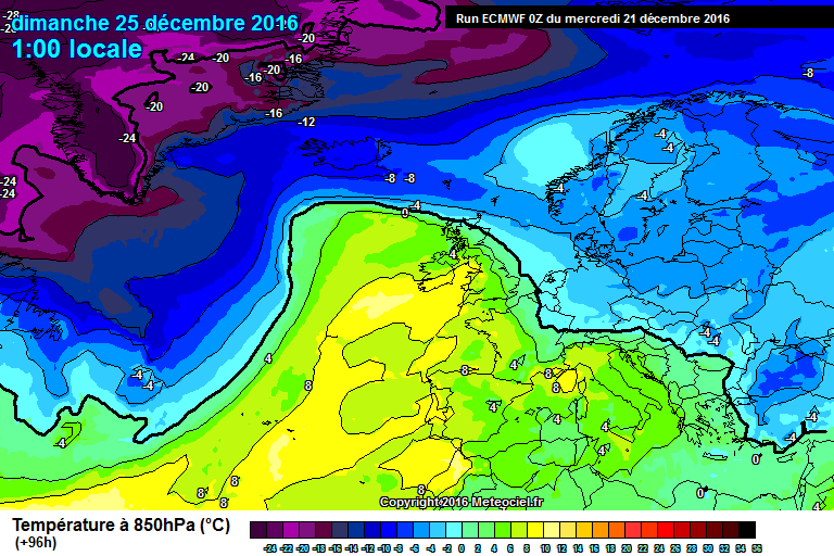
17 minutes ago, IDO said:
That is fleeting and Christmas day looks mild to me, especially the south. The ECM uppers:
London ENS
And GFS suggests Christmas Eve and Christmas Day highs 3c above average and I believe they are being too progressive with the Atlantic and will have mini-ridge trough combo rather than stormy come the day, more like ECM and GEM.
Christmas Day looks mild, but the 20th, 22nd, 23rd and the 24th all look below average even in the temperate South for once. Are you cherry picking your comments now I'm Dreaming of A White Christmas?
Anyway, I'm intrigued by what you think might happen by D16 and will await those analyses with interest. To my mind, tonight's ECM is something to be treasured given the flow is largely from off the Atlantic throughout. Much to be cheery about IF the ECM were to verify, not perfect for coldies but any means but NOT as desperately poor as some might think it is, from reading in between the lines on some of the posts in here tonight. Off to watch the darts, enjoy your evening IDO and everyone else!
-
7
-
-
49 minutes ago, Captain Shortwave said:
Now before I potentially go on a bit of a rant, can we just call the upcoming week zonal, because it is not a cold zonal pattern, cold zonality comes from a suppressed jetstream over central/southern Europe with the polar vortex positioned mainly to our north/north east allowing the Azores high to be placed further north in the Atlantic. Hence a dominance of west to north west winds with the jet still blowing strongly.
To point this out for every colder shot, there is a milder slot following quickly behind.
Charts for Thursday through to Sunday, cool/mild/cool/mild, temperatures coming out near normal ,again perhaps siding a little above due to the wind preventing cold nights.
A perfect analysis of how things currently stand, the good Captain I thank you muchly.
At least that's a posting I've managed to take something from, given all the private conservations between individuals in public in here previously. However, I do believe wintriness is likely to feature more within the media forecasts as we approach the big day. The 23rd/24th December remains of interest for coldies away from my back yard, as does post Boxing Day. With forecasts hinting at even the remotest chance of a few people seeing some magic white crystals, I'd grasp that opportunity with vigour giving the far from perfect stratospheric conditions right now, so enjoy it as and when it does come about. How's the ECM unfolding anyone?
-
4
-
-
47 minutes ago, Summer Sun said:
High pressure over Europe drags up a lot of mild air in between Christmas and New year
In six months time, I'd love those charts to verify (I bet you would too, Summer Sun), hopefully that's where they'll stay, come the more reliable ECM 12z runs.
-
53 minutes ago, IDO said:
FWIW Christmas Day now a washout into Boxing Day. Not that it will happen, but hard to call that wintry:
And remember uppers generally downgrade on the GFS as we approach T0. The GEM is quite mild already washing out the upper temps:
Zonal for sure but cold zonality not really. As for snow, sea-level unlikely IMO even up North, down south no chance at the moment. After D10 upper anomalies way above average for western Europe. That promises a very mild post Christmas period, though that is to do with the trending resurgence to mid-lat of the Azores energy; however where the core high sits will guide us to surface temps and on this run very mild, conversely the 06z was cool.
Happy Christmas to you too, I'm Dreaming Of A White Christmas.
You're surely too wise (like all of us old-timers), to write off prospects of some transient snowfall come the festive period, especially given we are talking timeframes of t+19,000 minutes or thereabouts. Yet, you did cleverly present an argument for all options being on a table, I say it a few more days of model runs before jumping on board, the nothing festive happening train. BTW I do think the 22nd into the 23rd December holds some wintry interest for a few as this period has held firm as being that way over a number of outputs now.
Happy Christmas to everyone else too. Off out shortly, the ECM will likely restore some faith for coldies.
-
7
-
-
12 hours ago, gottolovethisweather said:
That's some serious depth of cold out towards Greenland but will it ever leave their shores. I cannot convince myself to look past the 21st/22nd December right now, but I have a feeling the period immediately around Christmas Day and towards the close of the year will be a memorable one. Everything but the kitchen sink springs to mind, so yes I favour an active period! Snow for some too with not everyone joining in the fun and a lot of transient stuff.
After tonight's cheerier updates (well, if you're active seasonal weather, they be cheery) I thought I'd BUMP my post from around midday. John Hammond's BBC long-ranger update was also an intriguing one.
Slowly, Slowly, Catchy Monkey.
-
4
-


 Deuce points.

 What of 2017?
 We have to laugh otherwise, we'd all cry.


 .
.


 Down IMBY it might not be much worth writing home about but matters not to me, there is much going on elsewhere for me and others to focus on. TAKE CARE.
 IDO, you are not alone in this as plenty of other folk do the same

 Anyway, I'm intrigued by what you think might happen by D16 and will await those analyses with interest. To my mind, tonight's ECM is something to be treasured given the flow is largely from off the Atlantic throughout. Much to be cheery about IF the ECM were to verify, not perfect for coldies but any means but NOT as desperately poor as some might think it is, from reading in between the lines on some of the posts in here tonight. Off to watch the darts, enjoy your evening IDO and everyone else!


Model output discussion - 5th December 2016 - Into Winter we go
in Forecast Model Discussion
Posted
I verify this as "Post of the day", nicely put together Aaki Khan.