


-
Recently Browsing 0 members
- No registered users viewing this page.
-
Our picks
-

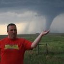
Storm Chasing Tour 2 report - Tornado in Oklahoma
Tom Lynch posted a post in a topic,
Storm chase tour 2 delivered again with another tornado on day 7 of the tour - this time in Oklahoma.

Picked By
Paul, -
-
Birth of a thunderstorm
Sky Full posted a gallery image in Member's Gallery,
Birth of a thunderstorm - captured by Sky Full-
-
- 0 replies
Picked By
Paul, -
-
TOUR 2 Tornado Alley
Tom Lynch posted a topic in Storm Chase USA,
Tour 2 of the USA storm chase is currently underway, and the team has already witnessed a one-mile-wide tornado.- 12 replies
Picked By
Paul, -
Storm Chase Tour 1 2024 - Photos and Highlights
Paul H posted a post in a topic,
Highlights and photos from tour 1 of the WeatherHolidays USA storm chase - including bonus Northern Lights.
Picked By
Paul, -
-
Northern lights spectacular May 2024
Eagle Eye posted a post in a topic,
Amazing Aurora photos from last night.
Picked By
Paul, -
-


Recommended Posts
Archived
This topic is now archived and is closed to further replies.