


General Model Output Discussion
-
Recently Browsing 0 members
- No registered users viewing this page.
-
Our picks
-

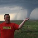
TOUR 2 Tornado Alley
Tom Lynch posted a topic in Storm Chase USA,
Tour 2 of the USA storm chase is currently underway, and the team has already witnessed a one-mile-wide tornado.- 7 replies

Picked By
Paul, -
Storm Chase Tour 1 2024 - Photos and Highlights
Paul H posted a post in a topic,
Highlights and photos from tour 1 of the WeatherHolidays USA storm chase - including bonus Northern Lights.
Picked By
Paul, -
-
Northern lights spectacular May 2024
Eagle Eye posted a post in a topic,
Amazing Aurora photos from last night.
Picked By
Paul, -
-
Major USA tornado outbreak possible
WeatherArc posted a post in a topic,
A major tornado outbreak is possible in Kansas and Oklahoma on Sunday 6th, May.
Picked By
Paul, -
-
How to quote a part (or all) of someone's post
Paul posted a guide in Posts and Posting,
While we trial the new 'reply-to' rather than quote button on the community, you may be wondering how to quote someone's post - click here to read a quick guide.-
- 0 replies
Picked By
Paul, -
-
-
Latest Weather News
Bank Holiday Weekend: Not a washout by any means, mostly dry for many
The Bank Holiday Weekend is looking mostly dry, though there will be some rain in the far west Saturday, while showers can't be ruled out elsewhere for the rest of the weekend, but most of the time it will be dry with some warm sunny spells. View the full blog here

A change on the way as midweek rain and blustery winds arrive
The recent settled weather has been interrupted by thundery downpours, but a low pressure will bring a shift to more persistent rain and blustery winds. Heavy rain in places midweek. Read the full update here

UK Storm and Severe Convective Forecast
UK Severe Convective & Storm Forecast - Issued 2024-05-21 07:41:17 Valid: 21/05/2024 0800 - 22/05/2024 0600 THUNDERSTORM WATCH - TUES 21 MAY 2024 Click here for the full forecast


Recommended Posts