


cooling climate
-
Posts
1,946 -
Joined
-
Last visited
Content Type
Forums
Blogs
Gallery
Events
Learn About Weather and Meteorology
Community guides
Posts posted by cooling climate
-
-
A stretched and displaced vortex this winter left some areas warmer (Spitzberg especially) and other areas colder but with a good possibility of a colder spring and summer again we should see the positive trend in multi sea ice, volume, area and extent continue with 2012 standing out as the anomaly rather than the trend or norm.
-
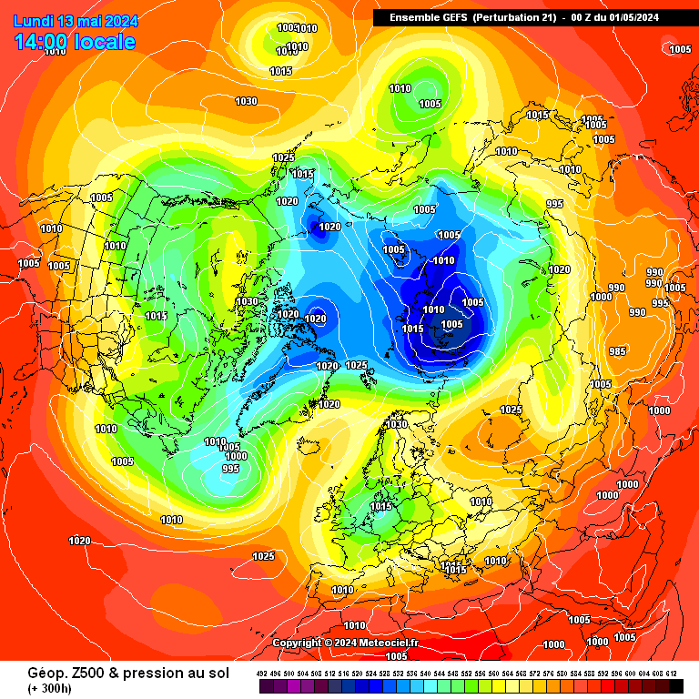
Plenty of eye candy in the latter stages of the 12z gefs this afternoon for Northerly fans with a
chilly looking ensemble mean.
http://modeles.meteociel.fr/modeles/gens/run/gensnh-21-1-300.png?12

Yes growing signs of a cold snap (spell) developing perhaps around the 19th onwards. Good strat warming forecast which would probably be the instigator of this and could possibly lead to colder and perhaps wintry incursions during April as well. Loving the dry spell but we have plenty of time for warmth and a couple of spring snowfalls would not go amiss.
-
 8
8
-
-
Let's not get sucked into thinking the second half of march will be cold and unsettled, just remember how the models have teased coldies for the last 3 months and we haven't had a cold spell or even a proper cold snap. The intensifying anticyclone next week could stick around for a fair while.
Regardless of what has happened in the last three months it has no bearing on what will happen over the coming weeks and I for one am still hopeful of seeing some snow,perhaps even laying snow before March or April is out.
-
5
-
-
The GFS starting to consistently model what looks very much like a final warming. This May well be worth following as high latitude blocking can still deliver something noteworthy and potent in mild to late March.
-
1
-
-
Winter 88/89 has always stuck out for me as being a memorable winter for all the wrong reasons very mild,wet and windy but this winter has over shadowed that I think. Stratosphere wise though they were two very different winters.WInter89 the vortex was very strong and positioned in situ over Greenland and the pole. This winter the vortex has been displaced with one section as we know over south east Canada which is not such a bad position had we had a negative QBOand more in the way of stratosphere warnings. We also saw persistent northeast Pacific ridges which is also a good synoptic (think 09/10 for example) to have had,had we seen greater warming and more in the way of blocking. An Alaskan vortex is normally a killer for winter as it promotes zonality across the state's which normally means similar for us. I could be way off the mark here but I believe a moderate to high active sun this winter led to the very strong QBO which scuppered the chances for stronger stratosphere warnings and blocking.
-
1
-
-
I was reading through a paper on solar forcing and came across this paragraph about polar vortex condition in relation to QBO and solar cycle phase.
Does this not contradict the earlier comments about the vortex being very strong and cold because we are now in Smax/wQBO?
Full paper.
http://onlinelibrary.wiley.com/enhanced/doi/10.1029/2009RG000282/
Near to the start of this winters strat thread I linked to a recent paper which challenges the theory that during solar max and w QBO sudden strat warmings are more common. I believe there is strong data to support the cold strat w QBO theory.
-
2
-
-
The models more in line with what I would expect to see going forward. Expect to see more upgrades in future runs for a colder and perhaps more wintry outlook.
-
2
-
-
With over 50 years behind me this will be the first winter where there has not been a single flake of snow during the three winter months (Dec, Jan and Feb). I thought 88/89 was bad. I am reasonably confident however of seeing something more wintry during March however with much more in the way of northern blocking.
-
Is the earth's temperature not higher than 150 years ago then?
Has it not stopped rising for short spells in that time only to start the upward trend again?
Has the sun not decreased in activity before during the same period?
basic questions CC, have you the answers please?
To answer all three questions in one I will say
I am not denying there has been warming but that stoped some 16 years ago. Before then
there has been cooling and warming periods which would tie in with natural climate cycles
PDO, AMO, NAM, enso etc but the warming we have seen in the eighties and nineties I
believe was due to a very active sun lag effect during the 20th century which is now going in
the opposite direction.
The IPCC said the warming would go on unabated reaching Xc by the year blah, blah. Then
when the warming went into hiatus as it has done they ran around like headless chickens
trying to explain it and finally came up with enso and PDO cycle to explain the pause.
How come they missed this. The truth is they probably didn't it is just a poor excuse for the
missing warming. There are so many other things I could go into but to tell you the truth I
really can't be bothered I know the warmists have their blinkered view and the sceptics have
theirs and to keep going over and over the same arguments is tidious to the extreme.
If there had been warming for the past 15 years or more then there would be no argument but
there hasn't pure and simple.
-
2
-
-
It's been explained to you numerous times! Over short time frames factors such natural variability is dominant. ENSO can add or take >0.2C from the global annual average temperature, while the effect of CO2 is less that 0.2C per decade. So when you start a trend line at a very strong El Nino, such as 1997/1998 (possibly adding around 0.3C to the temperature) and then follow it through a La Nina dominant period, the warming trend will be reduced, which is what we see.
GISS ................ .................... .................... HADCRUT
UAH, JMA, NCDC and others show a similar slow warming trend, actually only RSS shows no warming trend. But when you consider the record strong Pacific trade winds, the low solar activity, the -ve PDO, increased aerosols, etc, it's remarkable that we're not rapidly cooling!
Too many people think that because a forecast was vaguely correct, that the methodology and science behind it must be correct. The fact of the matter is, that so many forecast are made each year that some are bound to be right, whether their method uses tea leaves, hallucinogenic conversations with rabbits, their misunderstanding of teleconnections or whatever else. The odd correct forecast doesn't mean that the methodology is either sound or scientific.
Only time and a thorough analysis of the scientific basis to ones forecasting methodology will show it to be worthwhile or not.
You do not have to explain anything to me Voidy. There has been no warming for years apart from small
fluctuations in temperature up and down,but if the sun is to go into hibernation ( most pointers are looking
that but you probably can not see that either) then there is only one way the temperatures are going and
that is not up.
-
1
-
-
Do those not infer winds from the opposite direction as in normal weather, ie - an Easterly is the Westward movement of air surely??
Yes you are right. The way its worded is not very good but as you say a westward movement
of air is of course a easterly or negative QBO.
-
1
-
-
For those who seem convinced that climate change is a fraud, I would love to read your peer-reviewed scientific research that disproves it, so send me a PM please
Climate change has been going on for millenia and will continue to do so.
-
3
-
-
Ian Pennell who opened a thread in the Autumn entitled late Autumn and winter 2013/14
mild stormy short cold snaps later.
His long range forecast made on the 20th of October was virtually spot on and the reasoning
behind it was also excellent, 95/100 I think. One of the most accurate forecasts I have read in
years.
-
6
-
-
I won't bother-keep your blinkered view, fortunately the majority of people have a more open mind, dare I say ? more common sense than a lot of your posts suggest with you
You are getting very fond of putting people down. Do you remember Mr Ian pennell from the late Autumn
and Winter thread 2013/14 who made a very well reasoned and explained forcast back in October 2013.
He then updated on the 3rd of December saying that he forecast for the winter was looking very good to
which you replied "Come on you COMIC its the 4th of December and you seriously believe your forecast
is correct for WINTER after just 3 days today being the 4th.
His forecast has been virtually spot on together with his reasoning and made more incredible by the fact
that it was made in October. I wonder if you will take your blinkers off for long enough to acknowledge this
and withdraw your insulting comment.
Netweather would do well to sign him up for their longrange forecasting team.As for the Meto I love the
way they portray themselves as all knowing after the event. May be they should contact Mr Pennell
themselves.
-
2
-
-
No, because there's a very high probability that 'CO2-inspired climate change' will be mentioned in there, somewhere. In which case my time would be better spent reading the barcode on a bag of cat litter. If I've presumed wrong, let me know. Thanks.
Your right of course.Just read the article and they are still banging on about the fallacy of
global warming. There has been a hiatus of warming for the past 16 plus years and there own
predictive forcasts over the last several years have all been found to be to warm compared to
what actually verified.They go on to say and I quote "the warming we are already committed to
over the next few decades". Does that mean that even if the climate which hasn't warmed shows
a cooling trend they will ignore it and continue to promote global warming.
In summary they say it is down to a number of varibles although my bet would be that the very
strong westerly QBO played an important part and perhaps along with a sun that was at times
asleep and the next very active which may have aided the strength of the QBO.
On the BBC one morning last week they blamed it on a cyclone in the southeast pacific in
November that led to the winter we have had. Had a laugh over that one.
-
2
-
-
I'd be surprised if this is correct as this was a single bang sort to speak. We've had eruptions that were explosive and lasted longer in recent years.
Karyo
John Search has been studying volcano's for years and I can not imagine he would tweet
something like that off the top of his head without data or satelite imagery at hand.
-
John Search has tweeted that the sulphur dioxide plume from the
Kelut volcano is the largest in the world for many years.
-
My long range forecast for winter 13/14 for the UK bombed. There was though one
part of my forecast that was very accurate and that was persistent ridging in the north
east Pacific with the vortex setting up home between Hudsons Bay and southeast
Canada.I was expecting a more - AO though similar to 1977 which was my undoing.
I don't know how many remember the winter of 77 which was brutal for the midwest
and northeast US but being a -QBO we saw much more in the way of northern blocking
which is why even though the vortex was in a similar area we had a completely
different winter. Of course there were other factors involved as well such as enso etc.
Anyways back to my forecast for the UK this winter and I will have to award myself a big fat 0.
-
1
-
-
Well the charts you said were wrong for the past couple of weeks turned out to be correct, with no real background signals to drive a pattern change except the gradual waning of the cold and unstable conditions over Canada, then it's more likely we will we pressure rise from the south rather than from any other direction. Whilst there might be weak heights to our north, all they will probably do is help bring more rain to the UK as low pressure is forced between the two competing high pressure systems.
I think you may have your wires crossed. I have said for days now we would see a more amplified
pattern with heights to the north/northeast developing due to the strat warming we had.
This would develope from mid February along with colder weather which I then put back
to the last third of February several days ago. I also said that we would not see strong
blocking like 2010 etc but shallower heights but heights none the less.
-
1
-
-
The outputs this afternoon do not look that great from a cold perspective but I do not
believe everything that I see in the model output and would suggest that what the models
are now showing may well be underplaying the amplification in the pattern ahead.
T120 onwards is still very much up in the air so to speak (no pun intended).
-
Hi Tamara - I think to be fair whilst its all nicely written your basing all your assumptions on persistence rather than anything scientific.
There is one key thing that you, me or the met cant forecast with any confidence is when things will change, & this is the problem & one that will plague us with years to come.
In terms of the overnight ECM evolution & what you've presented (BOLD), theres nothing there that will actually stop the ridge moving North if that's whats going to happen.- & in reality makes all the science & all the wonderful wordy posts that you or I may punt forward- it makes it mute.
Take Dec 27 1984- this looks horrific.
http://modeles.meteociel.fr/modeles/reana/1984/archivesnh-1984-12-27-0-0.png
492 heights over eastern Canada, deep deep depression aligned towards the UK - looks pretty hopeless.
However against the odds an atlantic ridge gets NE
http://modeles.meteociel.fr/modeles/reana/1984/archivesnh-1984-12-29-0-0.png (29th)
move onto the 2nd of Jan
http://modeles.meteociel.fr/modeles/reana/1985/archivesnh-1985-1-1-0-0.png
All of a sudden we have a modest Svalbard high & an atlantic ridge culminating in this
http://modeles.meteociel.fr/modeles/reana/1985/archivesnh-1985-1-4-12-0.png
The bottom line is this winter has been cr*p, but at some point it will change & at that point it will make all the posts that forecast persistence look stupid.
Tonight may be it, we may wipe the whole of winter out- but just because there is vorticity to the NW & or no imminent change- doesn't mean a change isn't imminent.......
S
Unfortunately with the example you give of end of December 84 there was a major warming with a
SSW in early Jan and an imediate trop response. In fact it was in a very similar locale to the warming
we have just had albeit far stronger.
-
They are usually very good and much better in my view (others disagree) than the synoptic models. If the 3 are very similar over about 3 days to each other and consistent then about 70% accuracy at 500mb. The clever bit then is to try and get the surface pattern close.
Yes I can think of one instance when the synoptic models consistently showed a change before the anomaly charts but just the one I can recall in 4 years daily watching throughout each year.
Sounds like selective memory to me. There have been several at least in my recollection. It is for this reason
I do not subscribe to your methology.
Back to the here and now and the heights and amplified pattern that I have been banging on about since the
start of the month is trying to exert itself in the NWP charts. The ups and downs especially by the ECM (again)
may mean they are rushing this slightly which is not uncommon when the models try to bring in a more
amplified or blocked pattern.
I still stand by my forecast of a much colder last third of February and on into March.
-
1
-
-
I certainly would not be shouting about the ECM this winter. Compared to what we have come to
expect from the model I think it has had a very poor season.
I said in an earlier post that the amplification between t120 and t168 is far from settled and
because of this it is harder to look beyond a week with any confidence. The pub run holds a lot of
interest tonight and may well be showing the ECM the way forward. Then again it could be just that
the pub run.
-
3
-
-
There seems to be a lot of potential (yes that word again) around the t120 to t168 mark for
amplification to the north. Until the models agree on the amount of amplification it is hard to
judge what will happen beyond this time frame. Another 24hours modeling should give a
clearer picture as to where we are headed in the next week or so.
-
4
-


Model output discussion 13th Feb onwards
in Forecast Model Discussion
Posted
A change to much colder wintry conditions courtesy of stratosphere warming continues to gain momentum and should soon be in range of the ECM model.H500 anomaly charts and ncep 8-15 day charts should soon pick up this change.