


cooling climate
-
Posts
1,946 -
Joined
-
Last visited
Content Type
Forums
Blogs
Gallery
Events
Learn About Weather and Meteorology
Community guides
Posts posted by cooling climate
-
-
UKMO on its own tonight a t96 with the ECM and GFS almost identical.
-
The differences between the UKMO and the GFS at just t96 are stark.
The GFS has the low a few hundred miles further north and 20mb deeper
also the high is centred over Moscow compared with UKMO which has it
just to the east of Svalbard. Crazy at such short range.
Just seen the UKMO t144 chart and its a beauty. Mr Murr will be happy
with that.
-
 1
1
-
-
If I am reading that right it is not a 2m temperature but an anomaly thereforeGFS continues with its cooling trend for mainland UK this afternoons 12z 8 day temperatures anomaly is another cold one for all but the far south west, Kent and parts of western wales where temperatures are marginally above average here

it is not really that cold at all,just 1c or so centigrade below normal.
-
Apart from half a dozen posts just wizzed through 8 pages of will it snow
why are the Met not on board etc,etc.
GFS t120 and low to the south over France with a continental feed and -2c
to -3c uppers so rather cold for much of England and little in the way of
snow for low laying areas.
It will be the end of the working week or start of February as I said
yesterday before we see anything in the way of snow apart from further north.
-
Well I certainly will not be waxing the skies just jet.I see no reason to
change my initial thoughts of rather cold with some hill snow next week.
Perhaps the chance of something more wintry further south from t168 onwards
but unlikely to see any proper cold laying snow until February now.
Just like the ECM op I have not been overlly impressed by it ens members
either this winter.
Anybody forget to mention the UKMO model tonight synoptics look ok but lack
of cold air is a problem.
-
The wave 2 starting to feature more and more now with even a split possible.
A fair way out yet but the sblit is in a very good location for us if the
charta are anywhere near the mark.
I think weather wise for February we should perhaps be looking to our east
which is of course also where our coldest weather is normally sourced.
Personaly I definitely like the trend I am now seeing from the strat models.
-
1
-
-
The ECM t144 chart is a dream winter chart with a channel low and Scandinavian
high plus its January what more could you want... Ah yes cold air. You could
not make it up.
The t168 chart does offer something of a more wintry nature as does the t192
and beyond that it looks like weak heights to the north and the lows traveling
on a more southerly jet which could make for some interesting weather if we
can get some cold into the pattern.
-
1
-
-
Nothing very inspiring tonight from a coldies point of view.Next week may well
be rather cold with temps of 5c or 6c and some hill snow perhaps but nothing
in the way of proper winter weather,freeze etc.
It is certainly looking as if low land areas of the UK especially in the south
will have to wait until February for a chance of any proper cold weather ie
laying snow etc.
-
1
-
-
Must admit the 18z FI seems to be playing out the way I would expect to see
things evolve due to the strat warming as we move on into February.
-
2
-
-
A SSW is not the be all and end all as long as we can get some decent warming
well into the Arctic which will allow for greater amplification in the region.
This can of course be through wave 1 or wave 2 as we all know.
-
1
-
-
It would not take a huge leap of faith to see the JMA being right from t144 onwards.http://www.meteociel.fr/modeles/jma.php?ech=24&mode=1&nh=1&archive=0 JMA wants to set off a Rampede tonight ( 3 days running ) Inline with the UKMO but shades better- ECM 168- NICE but not the best run of the day S
-
LOL what the hell is going on. We got the ridge amplification but the low
does not want to sink south. Stupid I known but it is as if the models are
conspiring to keep the cold out of the UK.
-
Never can tell with the ECM these days but looking at the t120 chart I
would expect a much better run tonight with a more amplified pattern
than the 0z this morning.
-
1
-
-
In the past I would have agreed with that statement 90% of the time butIf only the BBC forecasts were in Netweather-speak: "Brighter spells tomorrow followed by soul-destroying messterlies as the PV continues to splodge its duff over the UK."
Meanwhile, this is much better than the ECM earlier as no energy migrates from Siberia back across the pole.
You wouldn't bet against the ECM though.
this winter the ECM has been all over the shop the same as the rest of
the models.
-
2
-
-
I would not be at all surprised as Recretos post above shows with a couple of
the GEFS members that we will see more in the way of wave 2 being modeled in
the strat charts in the days to come.
-
2
-
-
Strange run in as much as there is much stronger ridging over Pacific
north America compared to the 12z run yet the heights over the Arctic
are not as good.
-
Looking at the ECM,and GFS t192 charts and the JMA at t168
the similarities are obvious. There are of course some differences
which you would expect at the 7 to 8 day range but with a Arctic
high sitting over the pole and an Azores high wanting to ridge north
I woul not bet against the JMA tonight.
-
2
-
-
I must admit to being disappointed by the ECM t192 chart as I thought it was going
the same way as the JMA.Things certainly looking a lot more interesting from the
models with some real potential as we go through next week.
May soon have something to get excited about in the days ahead.
-
Silly question but does it matter what a certain Chrisfawkes thinks I would
prefer to believe the consistency of the strat charts myself. As for an
actual SSW this warming does seem to want to have a good crack at it.
Great post again Recretos.
-
Good post.I have not seen one post where anyone is saying deep freeze and raging blizzardsare on the way all we are saying is that a pattern change to something much more in linewith winter weather may be on the way.The GFS is less keen on Arctic heights this morning and the trouble sometimes with waveamplification and effects on the troposphere is that the models can react to quickly tothis although this is of course just one run. The ECM this morning tanks the AO as ithas consistently being doing the last few runs. As for the UKMO well what can you sayeveryone has moved on past the will it won't easterly except for the UKMO but since itson its own its probably best to ignore I think.I think John you have turned into a bit of a Grinch this year. I think the only victim of models seems to be you. I haven't seen anyone hype it out of proportion, just some analysis on whats put infront of us. Again, the only one taking it out of context is you.
-
1
-
-
- Popular Post
- Popular Post
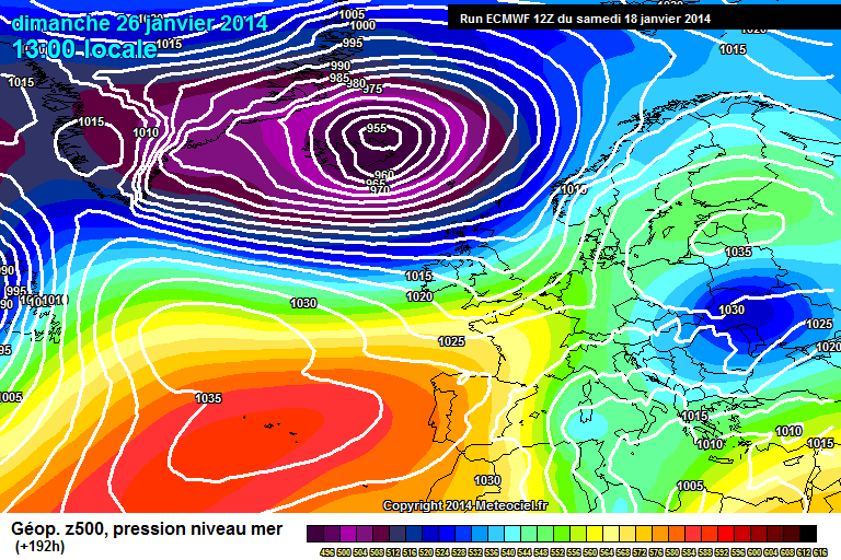
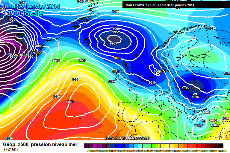
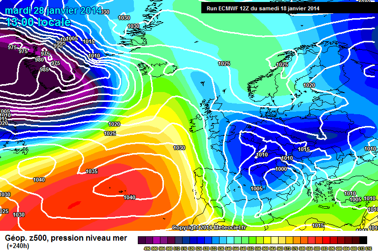
With the amplifing pattern the low has no choice but to disrupt and undercut. Plusyou will not have to worry about shortwaves running northeast or east into theblock but would in fact move south or southeast.I think your quite right in that some stella runs are not far off in the model runsand that the chances of real winter weather in the extended range is gainingmomentum. The ECM and GFS has started to become quite persistent with a tanking AOand possibilities of a link up with a Scandi high.If this does happen then ourchances of seeing some proper cold will greatly increase because the energy and lowsthat will continue to want to push east will have nowhere to go but southeast andundercut.Some posters this evening are either blinkered or have no idea what they are lookingat. We have not seen anything like these sort of blocked charts showing in the modeloutput this winter until now so things are definitely not the same.In a couple of days time it may well be a case of not will it get cold but how coldwill it get.I saved that insane cold op run from the ECM ens last night just to seehow near the mark it may be in 10 days time.If things go our way it may not be that insane a run after all.Also some people are confusing the H5 anomalies with the surface feature. The person that posted the 5 day ECM for today & from 5 days ago shows the ECM has nailed the whole pattern, the issue being if your living in the UK then the models error at day 5 can mean a swing of 10 maybe even 15 degrees for us. However it nailed the height anomalies in the right place. If you look at 168/192 if its modelling those height anomalies correctly again then the odds are FAVOURING a cold NW Europe as opposed to an atlantic driven pattern due to the teleconnections that support the anomalies. Our best chance of cold this season & certainly better than the beat up coke can scandi high from this past few days. S Just to show whos boss look at the low disappear in 48 hourshttp://www.meteociel.fr/modeles/ecmwf/runs/2014011812/ECM1-192.GIF?18-0 955 LOWhttp://www.meteociel.fr/modeles/ecmwf/runs/2014011812/ECM1-216.GIF?18-0 990 LOWhttp://www.meteociel.fr/modeles/ecmwf/runs/2014011812/ECM1-240.GIF?18-0 1010 LOW over the continent.
-
10
-
I think over the coming days we are going to see mouth watering charts
with the east definitely the direction to be looking towards the end of
the month onwards.
Looking forward to the ECM model picking up the very strong warming that
the GFS is showing which should be in the next day or two.
-
1
-
-
GFS t186 nicely poised are we going to see a GFS special
this afternoon I wonder fingers crossed could be first one
of the season.
-
Do not see much of a downgrade as you call it in fact I think it has been prettyconsistent since it first started showing up in the strat charts. The only thingthat has been inconsistent is as Ruben Amsterdam says and that is the modeling ofthe effect it has on the vortices.It should soon (another day or two) be coming into range on the ECM charts hopefully.The warming has downgraded in the last couple of runs. The vortex doesn't split at the 30hpa. Karyo
-
1
-


Model Output Discussion 19th January 2014-18z onwards.
in Forecast Model Discussion
Posted
I only use the three models ECM,UKMO and GFS if there is not agreementbetween the three of them then I conclude there is a problem with thepattern they are showing and do not bother to look elsewhere to try andback up the pattern I would prefer to be right. That to me is strawclutching. When the UKMO came out I wondered if it was to good to betrue although it does seem strange that the UKMO would be that differentat such a early timeframe. After all at just 4 days out these are verybig descrepencies between the UKMO and the ECM,GFS which I mentioned in aearlier post.