


snowlover2009
-
Posts
751 -
Joined
-
Last visited
-
Days Won
3
Content Type
Forums
Blogs
Gallery
Events
Learn About Weather and Meteorology
Community guides
Posts posted by snowlover2009
-
-
Some very interesting FI charts popping up, even the ECM is not far from showing a high latitude block to our north, this is amazing:
http://hw.nwstatic.co.uk/gfsimages/gfs.20111103/18/384/h500slp.png
Nothing record breaking, but the massive potential for the rest of the month and into December
-
Mark Vogan is part of Accuweather isn't he? Plus, I heard hints from JB going for more cold for us this winter. It does look good.
I cannot get over that in 30 days it will be winter. Not officially, but some, like me class it as winter. Also that people will be in Christmas mode!
-
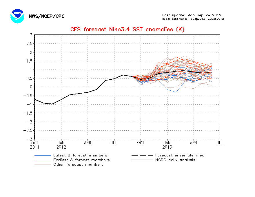
The way this is heading, the La nina will end up being weaker, than last year, with how the forecast members have flipped. The grey and blue ones are the new runs!
http://www.cpc.ncep.noaa.gov/products/analysis_monitoring/lanina/images3/nino34SSTMon.gif
I think we could be odds on for a major shift from very mild weather to very cold weather in the coming weeks. Watch this space. Something similar to November/December 1981. Looking in the archives, you would have never have guessed the December coming would be a record cold month. The pattern just suddenly shift. I don't know what you guys think.
I am not saying a repeat of last year of when the cold came early, but some forecasters are expecting the cold to come in the second part of winter. If this is the case, judging by the new cfs link above, I think the cold could come early as next month.
-
GFS FI Is nice and settled tonight with high pressure around. Rain fall looks low for a good while yet.

Anything after next week is looking a bit better, but that is way out and probably going to change a lot. The models have been flipping a lot out in FI. It is looking very autumnal and unsettled next week to my eye, so rainfall won't be all that low as you say.
To my eye, I see the jet heading south, which could result in more unsettled weather, but if it tracks too far south, we stay dry.
-
While, people may want support from the ecm, to back gfs up, GFS does show polar maritime air to start November, before the cold showing in FI. The ecm, only last night and the day before also showed polar maritime air, with that huge storm. So, not a million miles from both showing the same thing.
-
Looks like the models are firming up on an unsettled and cool start to November, with phases of polar maritime incursions.
I think we could be looking at a very unsettled month.
-
Wouldn't more ice around Greenland, mean less blocking around that area and also more snow further south, could also mean less blocking further north. With less blocking to the north, the snow extent will shift south, but only so far I imagine. But I could be wrong.
-
The jet crashing into Africa!
http://hw.nwstatic.co.uk/gfsimages/gfs.20111016/18/384/hgt300.png
Some promising signs showing at the moment. The ECM is my favourite though tonight. Both have the Jet way south.
-
Im not sure why- but I cant paste into this thread-
The ECM 192 ( YES is a long way away) shows a key component for Winter- the jet diving south-
THe problem in this scenario is look what it brings with it!
A HUGE 960 MB STORM- Thats a real bad one-
http://www.meteociel...H1-192.GIF?15-0
S
All very November 2009 and we know what came after....
The blocking to the north, jet diving south. Perfect.
-
Superb charts across all 3 models. It's really hard to believe considering the output a few days ago was so dire..!
Can't help but wish it was 11th Nov though... are we coming too early?
Memories of that time and week, when we started to see the first cold charts, little did we know what was around the corner.
When does the GEM start to do its evening runs?
-
Wonder if the UK will get any pixels, also eastern europe should get some with the cold air coming through.
-
Some eye candy from tonights ECM in terms of northern blocking but still uncertainty as to how far east the pattern progresses. If the neg NAO is too west based then you could end up with the coldest air heading into the Atlantic.
The real interest doesn't really appear till post 168hrs and so alot could change in the meantime. However the trend is there for that northern blocking so certainly a chance for something colder in the outlook.
That would be disappointing, however ever it usually keeps us in the cool/cold air. It happened a lot last autumn, maybe November and look what happened. The storms usually dig more south from what I recall.
-
Christ, the weather watching and chart watching is starting to get interesting!
-
Here's the latest update:
That map is going to really take off next week.
-
It is absolutely uncanny how the models once again are showing stonking charts for the time of year. I was really not expecting this after the last 2 years. I agree, I think this is just the starters for a memorable November. Can you imagine the media and forum if we were to have a rinse and repeat of the end of last November, but a longer lasting spell throughout the month? Next week, looking cold and wet from the gfs, with wintry showers in Scotland over higher ground maybe? I could be wrong, but not far off is all I am sure of.
-
A major pattern change looks likely next week, while we see a good deal of northern blocking, the first proper and notable blocking of the autumn, it could be a very wet week next week and I don't mean lightly. However it is early days just yet:
http://hw.nwstatic.co.uk/gfsimages/gfs.20111011/06/168/h500slp.png
http://hw.nwstatic.co.uk/gfsimages/gfs.20111011/06/168/6hrprecip.png
http://hw.nwstatic.co.uk/gfsimages/gfs.20111011/06/177/h500slp.png
http://hw.nwstatic.co.uk/gfsimages/gfs.20111011/06/177/6hrprecip.png
http://hw.nwstatic.co.uk/gfsimages/gfs.20111011/06/183/6hrprecip.png
http://hw.nwstatic.co.uk/gfsimages/gfs.20111011/06/183/h500slp.png
A 2 day deluge and flooding very likely if it were to verify, we need more runs though, but it does look like proper autumn next week for the whole country and added to that some cold temperatures.
In FI:
http://hw.nwstatic.co.uk/gfsimages/gfs.20111011/06/204/h500slp.png
http://hw.nwstatic.co.uk/gfsimages/gfs.20111011/06/228/h500slp.png
http://hw.nwstatic.co.uk/gfsimages/gfs.20111011/06/252/h500slp.png
http://hw.nwstatic.co.uk/gfsimages/gfs.20111011/06/276/h850t850eu.png
http://hw.nwstatic.co.uk/gfsimages/gfs.20111011/06/384/h500slp.png
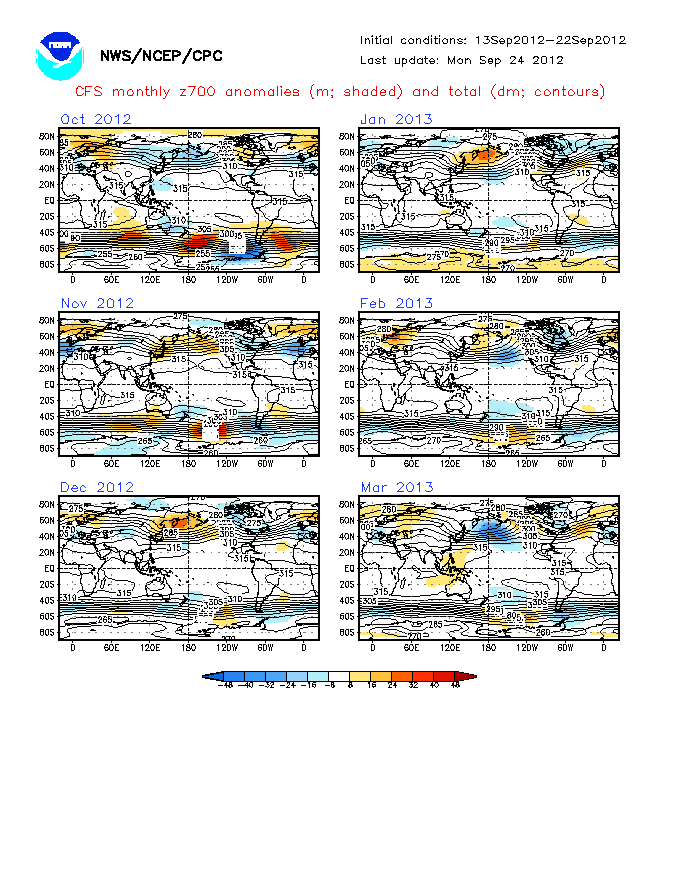
All very nice, but FI, however the same sort style of charts all pepped up 2009 and 2010 and some extent in 2008. I wouldn't be surprised if they were near the mark tbh. Cfs looks to support gfs, just saying:
http://www.cpc.ncep.noaa.gov/products/analysis_monitoring/lanina/images3/glbz700Mon.gif November pattern would probably match the gfs pattern in FI, that block would take some shifting. December starting to look anticyclonic and below average. If the La nina is being overdone like has been said before, December will probably end up looking similar to the November anomaly. Still early, but I am not surprised at the models at the moment.
-
Polar Maritime air, in my experiences of model watching, seem to always bring cold northerly winds or a cold attack at some stage, even in November 2009:
http://www.wetterzentrale.de/pics/archive/ra/2009/Rrea00120091127.gif
I would take it.
-
The fact is we still won't really know. November 2009 gave no indication to the winter.
Yes but looking back in the archives, you can see blocking was in place still, to the north and over Scandinavia:
It doesn't guarantee anything, but it is a good sign IMO, I didn't notice it as much until i looked back on it.
http://www.wetterzentrale.de/pics/archive/ra/2009/Rrea00120091111.gif
http://www.wetterzentrale.de/pics/archive/ra/2009/Rrea00120091129.gif
Throughout the month, there was occasions off weak high pressure building to the north of those low pressure systems that kept driving into the UK.
-
We do seem to be breaking more records in recent years or having usual events occurring. Summer 2007 and 2008? April 2011, November 2009, December 2010, November 2010, Winter 2009/10, October 2008 snow, summer 2006, winter 2007/08.
-
I can't see the GFS programming this at all on this mornings run for the bulk of the populated country. Looks to me like the GFS is continuing an Indian summer as Slowpoke suggests.
Well on that note this is all i can say, it look like temperatures will drop like a stone this week, with a possible mild up to above average temperatures for sunday/monday, nothing significant and clouds amounts being a problem, looking at the wind flow, thereafter, high pressure rises after with temperatures dropping slightly to around average, or just below, with night time fog and frosts. An Indian summer is characterized as an above average period of temperatures and sunshine. I don't get why people are getting hints of another Indian summer, when the weather looks fairly average to below after the weekend. I know things are likely to change, but at the moment that is what it is showing and the the white average line, is around 5c uppers most of the run. FI would bring consistent overnight fog and frost, with average temperatures or near average.
Can I remind you that an Indian summer is 'a period of considerably above normal temperatures, accompanied by dry and hazy conditions', from wiki, but it is true and I know this. I don't see anything considerably above normal in the forecast after today/tomorrow.
-
Indian Summer progged by GFS this morning!
I don't what charts you looking at, but 4 days or so of unsettled weather. Replaced by above average temperatures for a couple of days and a cool seasonal high looks very likely to me, with overnight frost and fog. Temperatures near average, if not below. I wouldn't define this as an indian summer.
-
I think any mild spell, if it comes after the blip next week, will be are average, sort of October mild spell, maybe something similar to end October 2009, maybe a tad less mild, as that was quite big mild spell for the time of year, wasn't it? This spell at the moment is an historic event, so any hope of another rinse and repeat will leave people disappointed, maybe low 20s possible in odd favoured spots in the south, if we get another major ridge, but I can't see it. The current pattern apparently is caused by an amplification of the jet, which produces intermittent ridges and troughs and giving north to south or south to north air movements ( known as meridional flow) as opposed to the regular west to east flow. Where these ridges and troughs are situatated dictate what type of airstream one is in. Either record breaking warmth (like now) or cold released from the poles (forecast). So the recent cold runs from gfs in FI and the colder ensembles on the models, maybe onto something. Could be an interesting month weather wise.
-
Though this lasted most of the month. In fact November 1st - December 9th 2009 was probably the longest unsettled spell since the pattern change. It was also wetter in Bristol than even October and November 2000!
also probably the last, longest spell of unsettled weather to the present, which is terrible.
-
Posted this in the depth thread, but this thread is always alive, so will post it here, if its ok:
Interesting post from Nickl over on weather outlook:
'this evenings noaa cpc update 6/10 day chart is possibly the most amplified that i can ever recall from the eastern pacific all the way to scandinavia. these set ups can be quite persistant and our outlook for the first half of october depends on where we end up sitting in the overall pattern. the whole of the month could well be quite blocked over the NH which has been quite well trailed.'
Interesting for those who are looking for some early cold/cool weather for October. 'most amplified that i can ever recall from eastern pacific' not sure what this means, however it does sound like a good response for any cold fans. Do you know what he means by that quote?
regards


Model Output Discussion - 14th - 20th November
in Forecast Model Discussion
Posted
I don't have a problem with the gfs runs, I don't know why other people do. Ok it isn't showing a deep freeze, but the cold potential is there in FI and the pattern only needs to move north a bit to be similar to ecm run this morning. We get a period of cold zonality too from gfs, which beats what we have had of late. So I don't know how people complain. Temperatures would probably fall below average with temperatures around 4 to 10c. if gfs came off from next Sunday onwards.The ukmo is good too. My neck of the woods already starting to feel more seasonal with a high of 8.8 today.