


snowlover2009
-
Posts
751 -
Joined
-
Last visited
-
Days Won
3
Content Type
Forums
Blogs
Gallery
Events
Learn About Weather and Meteorology
Community guides
Posts posted by snowlover2009
-
-
A massive cool down here next week, don't know what that will mean for the snow cover?
-
It is so good to have GP back again, I love reading his posts. However I do feel that again, this year we will see the core of winter In December and January mostly, after reading summer Blizzards analysis.
-
GFS 18z attempts to break this one down much earlier than recent runs, on that basis we can probably consign it to the bin, until tomorrow runs. It looks a little suspect anyway as it alters the air feed direction to a SSW'ly which seems a little unlikely.
FI with a it's intense high pressure scenario looks equally as shady.
I thought this too, however the high in FI is much cooler than the one this week thankfully. I can imagine night time fog and frost being a possibility. The cold to the north of us at the end is such a tease...
-
January 1795
February 1947
March 1947
April 2011
May 2003
June 2006
July 2006
August 2003
September 1674
October 1740
November 2010
December 2010 or 1890
Amazing how 2 months in the same year, both close together and just recently are popular choices.
-
There is definitely a trend for a pattern change for the following week(october) after the warm spell, it could be a big shock to the system. from 20 to 26c, to 9 to 15c in the first week of October if ECM tonight is to go by. Some gfs runs go below -5 air uppers, which would result in temperatures being below 10c for northern parts in particular, I would imagine. But we will see. I am not a fan of unseasonable weather, so sorry if I seem to by passing the fact.
-
It is nailed on that summer will make one more return and that will probably be it. Of course we can expect more dry sunny days, but any real warmth, then this will probably be it, summer temperature wise IMO. The charts do look juicy, but so sad they didn't occur during summer, even the start of September it could have brought us mid to high 20s widely.
I have to say though, the discussion above about how similar this upcoming spell is to the last week of September 1895 is extremely interesting IMO. Not only is it occurring on the same week and nearly the same days, but looking through the october archive, I wouldn't believe that it would go from this:
http://www.wetterzentrale.de/pics/archive/ra/1895/Rrea00118950925.gif
http://www.wetterzentrale.de/pics/archive/ra/1895/Rrea00118950926.gif
http://www.wetterzentrale.de/pics/archive/ra/1895/Rrea00118950927.gif
http://www.wetterzentrale.de/pics/archive/ra/1895/Rrea00118951001.gif
to this:
http://www.wetterzentrale.de/pics/archive/ra/1895/Rrea00118951020.gif
http://www.wetterzentrale.de/pics/archive/ra/1895/Rrea00118951021.gif
http://www.wetterzentrale.de/pics/archive/ra/1895/Rrea00118951022.gif
http://www.wetterzentrale.de/pics/archive/ra/1895/Rrea00118951023.gif Snow showers
http://www.wetterzentrale.de/pics/archive/ra/1895/Rrea00218951023.gif
http://www.wetterzentrale.de/pics/archive/ra/1895/Rrea00118951025.gif Wow
So it could turn out to be an interesting month, the similarities are uncanny. This is not an insult to anyone, but all I have to say is, for those who think it could be a long lasting event throughout, you only need to look at the above, to see how much things can change. But for now enjoy out late summer or indian summer!
-
http://jisao.washing.../pdo/PDO.latest
PDO data is in and shows that after the third most negative July on record, August was the second most negative (the most negative being 1955 which led to the sub-zero feb).
Anologues for the July-August period are...
2001
1984
1978
1971
1962
1961
1955
1952
1950
1978, 1962 and 1955. The PDO may do us a big favour this winter.
Very good analogues there and this autumn and potential dry and mild/warm october which looks pretty likely to me, is really starting to give me a lot of hope for this coming winter.
-
A dry month very likely unless we start to see models shift, but at the moment FI continues the dry, warm theme, although by then, anything will be mid to high teens, as we get cooler.
11.6c.
In summary a dry month, mild month, with a dramatic change to the end of the month as a proper northern block becomes established. The very end of FI show the smallest potential of this happening, with the high drifting more to the north west.
First week, average to above, but not as warm as last week of september. Second week, high drifting more to the north west, still mild for a time with the uppers a few chilly nights. Third week, high stalls in the atlantic and the UK, giving average to above average conditions with mild air still holding on. Last week getting cooler with frost become more predominant and the high noticeably setting up to the north west of the uk.
By the middle of the month, I expect the models to be hinting and leaning towards our first cold spell since last winter, giving us a very cold start to November.
-
The ecm is cracking, will it be a sunny high? I have my doubts, I do find it interesting though. The orientation of the high would bring bitter cold to the UK. If the ecm verifies, it will be a pretty warm end to september for the time of year and by the end of the first week of october, it could quite possibly end up being the opposite, by that i mean very cool air pushing in afterwards. The northern blocking which cfs and net weather are suggesting looks to be setting in after the warm spell, if these charts are to go by. One final round of summer and that is probably going to be as good as it gets till next spring.
-
Interesting ECM and GFS hint at a Indian summer for the start of October while the CFS doesn't.
Anyway I now know where this mornings media of freezing winter come from.
However we could do with some rain. This month looks like once again coming in below average continuing the dry year.
That is technically not true. They are predicting a warm spell for the time of year in the last week of this month, then ecm has a scandi high developed towards the end of September and start of October later in the run, which would eventually bring cooler and dry weather, when the warm uppers move away. So it is line with the cfs and net weather, the gfs I think is trying to do it, but failing. It has rarely shown a few cool spells in FI this recent week.
-
oh you wouldn't be saying this if you were in the firing line. I bet you was one of people ramping it and over exaggerating about or at least thinking it. Now we know what places will be affected your left disappointed, so you moan and belittle it!If I'm being totally honest, i think people are thinking this is going to be much more impressive than it really will be.
-
This storm has got me thinking about past storms. the last major on here was around the third week Of november, can't remember the date. Does anyone has any archive wetterzentrale charts for it. What were peoples views on it?
-
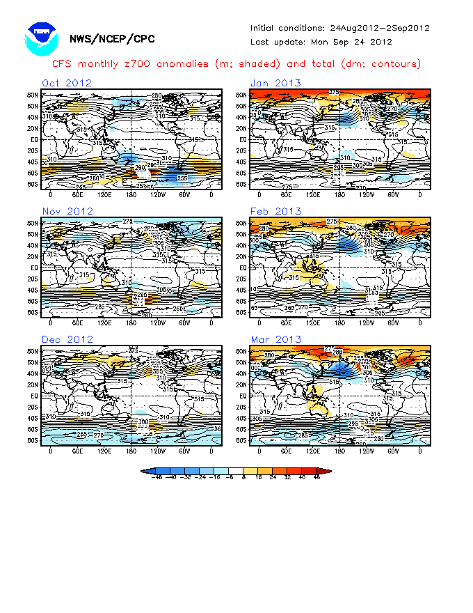
looked at the cfs charts lately? Starting to nudge more and more to higher heights, all very slowly, but incredible sign to see:
http://www.cpc.ncep.noaa.gov/products/analysis_monitoring/lanina/images1/glbz700Mon.gif This model not as good, but December looks ok, with probably occasional cold punt from the north as the pressure over the uk gets pushed south and then pressure rises slightly to the west.
http://www.cpc.ncep.noaa.gov/products/analysis_monitoring/lanina/images2/glbz700Mon.gif Oct and Nov blocked, -nao probably and cold. December, Stronger pressure to the west and northwest of the UK, not a big greenland high, but even in winter like 63 and 1890, pressure was still low enough to bring in the very cold air. Blue air mass in europe.
Jan looks ok, looks cold, can't imagine, it being that mild. Feb, well fantastic.
http://www.cpc.ncep.noaa.gov/products/analysis_monitoring/lanina/images3/glbz700Mon.gif Oct and Nov -NAO and blocked= cold. December blocked Atlantic with pressure nudging to greenland, =cold. Over recent days the trend has been for the oranges to move more north or being favoured position. Jan and feb would be cold, looks more favour for polar maritime air?
The way I see it, as long as there is not much in the way of high pressure to the south of the uk and blues all around the north, all looks positive, based on these charts. Most of high pressure is shown to the west, north west and near greenland.
-
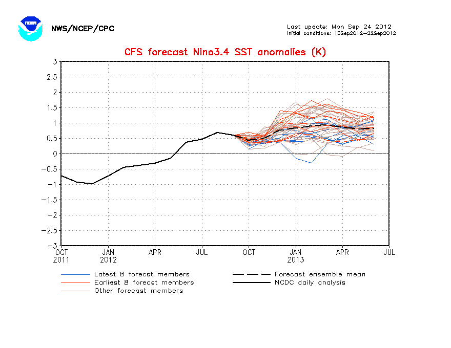
la nina is getting stronger around january 2012, some runs go off the page! If i am reading it correct
http://www.cpc.ncep.noaa.gov/products/analysis_monitoring/lanina/images3/nino34SSTMon.gif
Would i write believing this would be bad for cold lovers after december at least?
Oh well, a similar winter to last would not be bad, but hopefully if it does get milder, hopefully some massive storms and interesting weather!
-
has anyone noticed how consistent gfs in particular has been in bringing the jet south and pushing the azores out of the way and digging some quite strong low pressure systems to the south? I just can't wait for the cosy early nights, with the wind and rain hitting the windows.
-
summer is over -
Its been dead in the water since the last time I posted-
To much + VE blocking over the pole pushing the jet a good 1000 miles further SE than Normal for the Summer- If someone wants to reanalise this Summers 200 Charts then they will see the jet anomaly across the south of the UK-
There will of course be the odd flirtation with nice weather to come,- however the temp is now in the way down-
I recorded 12c on the car earlier in the rain- even this weekends decent weather has been supressed-
All I keep noticing is how far the 0c line is spreading south at this early stage across the NH
S
Wise words. I think autumn will kick off in style for once.
The thing is steve, if anyone else was to say summer is over, we would get people on the band wagon and moaning for writing summer off. But I agree with all you said, the 0c line is quite strangely spreading south early and the gfs runs have hinted at a lot of strong, deep atlantic depressions. Gfs has tendency to overdo lows, but the general theme would be unsettled, even if the lows are modelled wrong.
The +VE blocking over the pole is or has gone no where, I think we will need something extremely luck to get anything summer worthy for a week. The weekend 'heatwave' is a one day event to the south east and we have a good indication that it will be generally unsettled most of the time next week, which takes us to pretty much the end of August. People can say, it is still early and september can deliver the goods, but Personally I think the same pattern will carry on, if not more lively and obviously more autumnal. Problem is, it is alirght saying there is September, but I think pretty much most people, want autumnal weather to kick in or just lose interest.
-
Tonight's ECM brings with it 3 day's of settled ish weather next week, before low pressure takes over again;
http://www.wetterzen...ics/Recm961.gif
http://www.wetterzen...cs/Recm1201.gif
Gavin look at the charts again, there is a trough over the south east on tuesday which would bring heavy rain or heavy showers to parts of the country, monday and wednesday look ok, but probably a few showers and thereafter unsettled all the way to the end.
-
Anyway, I believe Dec and Feb are going to be the coldest months, with a wet and cool autumn, with some notable storms to hopefully look forward to.
-
Just for fun, the cold Feb pattern shown by the CFS since last month won't go away ..

nice, you have teased us twice with those feb charts, what do dec and jan hint at?
-
downgraded substantially, there uppers are not as strong. itll go sooner or later.
next weeks loking like a repeat of this.... a breif settled start before pressure drops and unsettled weather takes over for the second half of the week. although its not currently looking as windy.
I agree, pressure was expected to rise for a bit longer, but just recently it looks like the south will fair best for anything remotely settled from the south next week, with low pressure taking control again and central areas getting more rain this time as the low comes in on south westerly flow.
-
Just 15c, very autumnal feel, very dull, windy and blustery rain at times, looks like this evening/ tonight we will get our rain as we missed most of the frontal rain/
It maybe a mild night tonight, but I think the heating may go on for a bit later...
-
Just thinking the current sun has gone very quiet, compared to a few days ago. Now there was not many spots, but there is very little now, is it normal:
http://sohowww.nascom.nasa.gov/data/realtime/hmi_igr/1024/latest.html
Impacts on winter?
-
http://www.weatheronline.co.uk/cgi-app/reports?MENU=Seasonal-outlook
Sounds like my perfect autumn, generally cool, windy, unsettled as time goes on.
To note, it sounds like a continuation of the weather we have now, but one thing to remember, low pressure will be a bigger scale through autumn and will generally be more unsettled than summer is, e.g. wind and heavy rain. I just hope my dream autumn pulls off a cool and very unsettled September with Gales. October, very cool and unsettled, stormy. To the end of October, blocking taking place with a cold high, bringing frost and fog over Halloween and into bonfire night. November, cold with frost and heavy snow through the month, with the odd unsettled stormy period. A bit like last year, but it was not particularly wet in September and not many storms. The Atlantic seems to be waking up a tad recently.
-
To those mentioning the sun, well it looks quieter than it did a few week ago to me:
http://sohowww.nascom.nasa.gov/data/realtime/hmi_igr/1024/latest.html The dots are really faded and only one notable dot or two. Besides if we are heading to solar maximum, the sun is still very quiet.

Model Output Discussion - September Onwards
in Forecast Model Discussion
Posted
If the charts are to come by, we could see nearly around 16c drop in the upper temperatures and over 16c drop in temperatures. Temperatures predicted at 26c until Saturday, massive shock to the system.