


No Balls Like Snow Balls
-
Posts
2,978 -
Joined
-
Last visited
-
Days Won
3
Content Type
Forums
Blogs
Gallery
Events
Learn About Weather and Meteorology
Community guides
Posts posted by No Balls Like Snow Balls
-
-
Currently 9.8c and sunny whoop whoop
-
I am really liking the look of FI on both the ECM and GFS, plenty of PM incursions and even signs of heights building over greenland and the azores high linking up with this

-
UKMO has something quite different @ 144hrs, just a flabby area of low pressure, nothing like the GFS.
Yes UKMO is rather flabby, ECM on the other hand is quite tight, similar to GFS, worth keeping an eye on.
Edit: comes to nothing on ECM
-
All 3 major models now have this potential storm showing at T144, agree with earlier posts though that it probably wouldn't be as severe as GFS is modeling.
-
Not too far in FI either so something to definetly keep an eye on, although you have to say that there's a good chance it will get downgraded as it comes into the reliable!
Mild SWesterly winds then come in after, albiet briefly! 10c Isotherm not far away from the SW!
All in all a much more mobile and unsettled spell being progged! More active weather may finally be just around the corner for all!
Not sure I like deep FI though! A rather flat pattern with westerly winds, and the Polar Vortex pushed back up north into well.......... polar land!!
It's been showing this flat pattern quite a lot in FI at the moment, it never seems to make it any further into the reliable though.
-
12z is suggesting some very strong winds for the 24th/25th for south west England, South Wales and Southern Ireland!
All associated with a small but deep area of LP running along the English channel!
Not a good time to go sailing of the Isles of Scilly!
I think if that came off it would be the first time in a long time that the South got a good battering.
-
According to GFS 12Z it looks like it will be cool, wet and at times windy for most parts of the UK next week. Standard autumn weather at last maybe?
-
Currently 8.8c, a bit misty, but sun is threatening to come through.
-
Currently 5.9c
-
I suppose you could say that from the 21st of this month there is at least a very slow gradual cool down of upper air temps
If the GFS were to verify you could also say that from the 23rd onwards you would lose the double digit daytime temps for good, still nothing amazingly cold though but a start.
-
Currently 4.6c and guess what!! Cloudy again
-
ECM and UKMO are pretty much identical at T144 while the GFS is no where near at the same time frame, you could either say in this instance then that T144 is FI or the GFS should be ignored?, personally I would go with the majority and say the ECM and UKMO are correct with the position of the high for the medium term. I think this ties in with the METO outlook stating cooler in the East of UK. Could be interesting developments with the Azores high in 8-10 days time as GFS shows ridging North at T216 and the ECM shows ridging at T240, one to watch maybe?, it's not the first time it's been shown on the runs either.
-
Our weather is as dynamic as a dried up dogs turd at the moment (and that's putting it nicely)
-
I think you might be confusing Shetlands with Scilly... !
Not really. It seems every time i see the weather forecast for Shetland it's 12c no matter what time of year it is
. I don't think anyone would wish to see the same type of conditions all year round. I don't think it would take long to get fed up with it. -
We get a shot at real change in late December when the next burst of westerly winds is due to take place in the Indian Ocean, by which time seasonal wavelengths should begin to get a bit more favourable and hopefully the polar stratosphere should begin to warm a little. Whether this takes effect immediately or more progressively (I'll favour the latter) is open to debate.
The GWO is merely reflecting the overall global synoptic pattern so it is not in itself preventing a more favourable pattern from evoliving, it's just the entire system at the moment is fixed on delivering an Atlantic trough and downstream ridge over western Europe.
In terms of managing expectation, I would go for change into the second half of the winter as more likely, after Christmas at least.
Your like the grim reaper and pantomime villan all rolled into one
-
Seriously there is a time and a place for mild weather and the start of December is not it. I can imagine this current mild spell is what somewhere like the Shetland Islands is all year round.
-
Um Snow!, Yes please!!
-
It's good to see that there's no sign at all of any wintry weather, as yet, from this morning's GFS run. At least for those of us who have to worry about paying our electricity bills, that is...
That will go down like a lead balloon in here
-
Currently 9.2c, sun is coming through low cloud.
-
Just take a look at the 3 monthly chart
http://www.cpc.ncep....uT2mProbSea.gif
Not only does winter look mild but an early and much warmer than normal spring could be on offer next year.
I do believe the last update they did was showing December as above average, now they go for average, it's a LRF so it is what it is and probably subject to change every update. But they could be right too.
-
Good to see the UKMO now following the ECM
Did anybody mention how much I love Euro Highs? :')Yeah UKMO euro high is in much better position than GFS at T144, the ECM will probably back GFS now
-
With respect rich1, you are falling into the trap that makes this place so frustrating at times. The MDT exists to comment on what the models are showing, so to comment currently on a mild/very mild set up and outlook is not doom casting as you call it, it's perfectly fair and reasonable. Without question 99% of members want to see cold and snow, but until the charts show it you, I and everyone else only have two real options, either lurk and wait for colder synoptics or objectively comment on what can be currently seen, to imply cold when it isn't there is both pointless and more importantly misleading to less experienced/new members.
Maybe i was reading the post wrong but to me it seems the December forecast was made on 1 CFS run today!!. FI does not show anything that could be called a trend as we have 2 major models both pointing in different directions so it's far far far to early to call December, so maybe he was better off saying come back next week for a answer :winky:
-
No sign of the GFS 12Z moving towards the ECM 00Z solution at all, but no surprise there really. Still the low out West and the High out East with no sign of a breakdown in the reliable. Seriously we need to rely on the euro high moving into the correct position for any chance of cold at this minute.
-
What time does the GFS start to roll out?
about 4pm, the is a link somewhere on NW mentioning times of each model's runs.


 . I don't think anyone would wish to see the same type of conditions all year round. I don't think it would take long to get fed up with it.
 Did anybody mention how much I love Euro Highs? :')
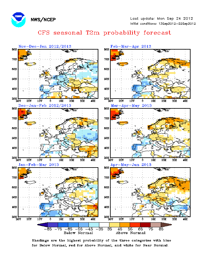
The Winter emotions and moaning thread
in Spring Weather Discussion
Posted · Edited by No balls like Snow Balls
One of the benefits is it put's a smile on people's faces as you see them outside building snowmen, sledging and having snowball fights. I believe it's what they call having fun, although i think some people are adverse to having fun no doubt.