
- Popular Post


weirpig
-
Posts
10,425 -
Joined
-
Last visited
-
Days Won
2
Content Type
Forums
Blogs
Gallery
Events
Learn About Weather and Meteorology
Community guides
Posts posted by weirpig
-
-
Looking into the future is difficult with the models. But it also looks like the here and now is also causing the models difficulties the low for Sunday is modelled in three different ways on the hi res models the euro4 going for a washout of a day for most of England. The arpege is going for the low to be more southerly and hardly any precipitation makes it past the south Midlands. And the arome has rain turning to snow for Wales Midlands and central northern England place your bets
-
Just for fun you understand! the above chart i posted was from the 0z this is the run from the 6z some might see the white stuff falling quite a bit of intense precipitation about. of course until the track is nailed down all speculation.

-
Maybe you and us maybe in for some fun and games fingers crossed.
-
BANK!
-
 2
2
-
-
2 minutes ago, Nouska said:
ARPEGE using some of Meteociel's new gizmos
Wow very nice what a lovely feature wales midlands and the north may see some pink pixels certainly not a boring start to the season
-
2
-
-
44 minutes ago, PerfectStorm said:
Was looking at that, keeps the 'colder' upper air temperatures on its northern flank, however it's quite hard to see what's happening when the frames are every 24 hours. Snow for the midlands?
i Think Nouska posted this link earlier it doesnt seem to show any snow from the ECM run although it isnt the easiest to navigate. And indeed the chart could be from last nights ecm
-
1
-
-
1 minute ago, feb1991blizzard said:
That's the dew point.
Lol whoops lesson learned look twice before you post . Yeah like I was saying rain
-
4
-
-
3 minutes ago, PerfectStorm said:
Not true. In fact it might be a push for snow to fall in the peak district.
It's all conjecture anyway but I would have thought snow could fall and 1 or 2c
-
1
-
-
2 minutes ago, CreweCold said:
The 6z had a threat of wintryness for low ground too
Yes this type of scenario always does well for the Midlands and further north think the uppers maybe a tad too high but high ground may well do well. One to watch
-
3
-
-
1 minute ago, Iceaxecrampon said:
Which LP? - the Sunday LP looks "interesting" for the Midlands to say the least - the channel LP is not exactly a default system which the models sometimes can struggle with.
Yes should have been clearer the LP at t120hours of course pinpointing the exact route it will take is like pinning the tail on the donkey
-
1
-
-
Having a quick Look Through the ensembles for the period regarding the low its a little bit of a mixed bag ( at this range it was always likely to be) Some have the low undercutting the Uk, Some have it bringing Snow to the Midlands and the North , And a few bringing heavy rain. one Perb even has the South east buried under snow.
-
2
-
-
All conjecture But the control as the first Low at t120 tracking more southerly with snow sleet rain on its northern edge maybe even the far south may see a sprinkle of the white stuff?
-
1
-
-
4 minutes ago, Spah1 said:
Fair enough.
However I do like extreme weather so it would certainly be exciting as my sons trampoline ends up in next doors garden
-
2
-
-
1 minute ago, Spah1 said:
Why do you want it downgrading?
I'm having a few days of work the latter part of the week I was hoping to sort out the garden before the onset of winter plus our fence isn't the best
-
1
-
-
Hopefully that feature will be downgraded on the next run. Looks very wet and wild one to keep an eye on
-
1 minute ago, CreweCold said:
Personally, that GLOSEA update is not for me...I'm looking at that thinking there would be frequent interludes of S'ly winds as low pressure stalls to the W and SW rather than running underneath the block which, may at times, be further S than Scandi.
Possibly Crew but all indications at the moment seems to be going for a front loaded winter the later half may be quite a lot more milder maybe influenced more by southerly winds. im still thinging we are looking at a cold if not very cold December.
-
4
-
-
Those charts are from Dec-Feb but are there charts available per month. ie a probability map for December,January etc?
-
7 minutes ago, No Balls Like Snow Balls said:
METO probability maps updated.
If im reading that correctly doesnt that point to the possibility of a warmer than average winter? if so thats quite a bit different to what they were saying earlier in the month as ever time will tell.
-
1
-
-
6 minutes ago, Summer Sun said:
looking at the 00z ens temperatures recover during the final full week of November before cooling down again right at the end of the month
Weather Online's thought's for the next week
Im a bit confused bt that is the last figure the daytime temps and the first night time?
-
1
-
-
maybe not cold for our little isle yet. But look at scandi again they are having a very cold start to the season.
-
4
-
-
Again remarkably similiar on the 6z at 144 now for the business end.
-
3
-
-
Lol same here lesson listen to wife when she says no more drink. Onwards and upwards
-
1
-
-
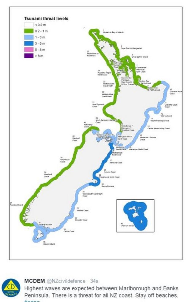
7 minutes ago, Gael_Force said:
It has been upgraded: 7.8 or 7.9, depending which site you look at.
3-5 metre waves forecast for the north east.
I've been watching this closely waves could cause quite a bit on impact. On a side note sorry
-
1
-
-
34 minutes ago, iapennell said:
BTW do any of you know about Accounting? I know this is a strange topic to bring up on this Forum but I am currently studying AAT Advance Diploma in Accounting and are familiar with how assets, liabilities, capital, expenditure and income are accounted for: A business is healthy with good prospects if it has lots of assets, has goodwill and is profitable- any Accountant will tell you this. Likewise, as you can divide money up this way, there are parralels as to how heat and momentum can be divided up.
So then, we have a situation where large amounts of heat are stored in the oceans at higher latitudes, the Northern Hemisphere has been (overall) absorbing more heat than it has lost over several years and there is a large amount of this heat stored into the oceans-particularly just west and north of Britain and this country is likely to be a benefactor of this stored heat in the coming months as it is released into the atmosphere.
Overall, thanks to the laws of Conservation of Angular Momentum, the Earth-Atmosphere system only leaks very small amounts of momentum to Space (chiefly through out-gassing and marine/atmospheric tidal friction due to the Sun and the Moon- the latter being much more important). However, to follow the Accounting analogy Westerly AAM as transferred between and stored in different Ledgers": In this case these ledgers would be the solid Earth, the oceans, the Troposphere and the Stratosphere/Mesosphere and with regards to the surface Easterlies are expenditure and Westerlies income. When excess Westerly AAM is stored in the Troposphere or in the stratosphere (i.e. Westerly QBO's) and there is a strong transfer of Westerly AAM into the atmosphere at low latitudes increasing this store, the atmospheric ledgers of Westerly Momentum would soon be bursting to the brim: As such these factors increase the prospect for Westerly AAM to be returned to the surface (using Accounting analogy there are assets and money in the bank for a businessman to draw upon for personal use). This only happens if there are Westerlies interacting with the underlying surface with the frictional impact with these causing a loss of Westerly AAM.
In other words, I hope that you can appreciate why both the heat and momentum budgets are such the they don't point to a hard winter in Britain.
Yes I have a CTA however I'm sorry Ian still don't understand brain must be overfilled with figures


.png.ffbd4873e5a1187797679e3f2179114c.png)


Model Output Discussions 06z 04/11/16
in Forecast Model Discussion
Posted · Edited by weirpig
Well that was fun! A humdinger of a Northerly dive barrel Lows cold air galore and the run ends with a easterly what could go wrong? easily the run of the season hopefully it sits at the mild end of the ensembles.