


Kirkcaldy Weather
-
Posts
6,693 -
Joined
-
Last visited
-
Days Won
11
Content Type
Forums
Blogs
Gallery
Events
Learn About Weather and Meteorology
Community guides
Posts posted by Kirkcaldy Weather
-
-
23 hours ago, thebigyin said:
I'm up to 30 Internet tabs open, most of which are weather related. I probably need some sort of counselling.
Think your 30 tabs are something... I'm at the stage my browser just puts a smiley
 theres too many to add up

-
 8
8
-
-
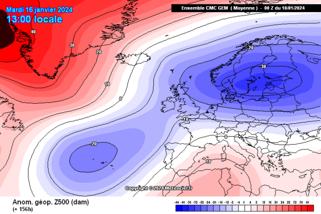
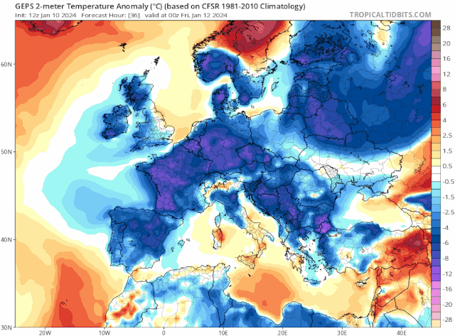
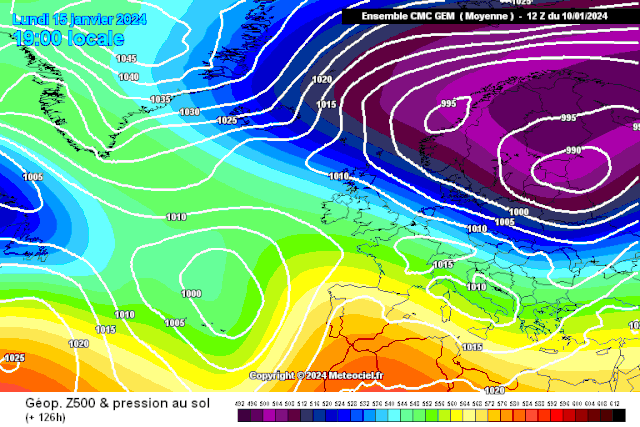
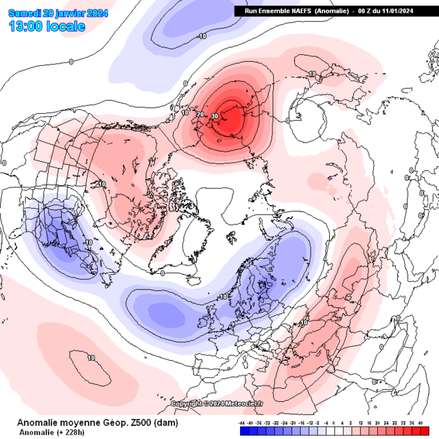
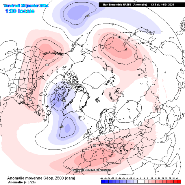
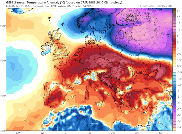
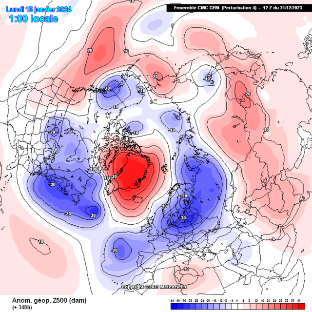
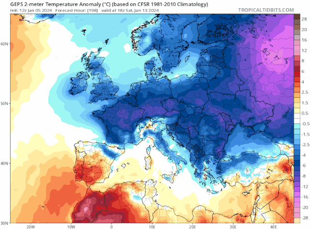
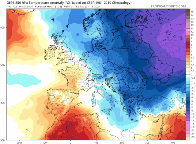
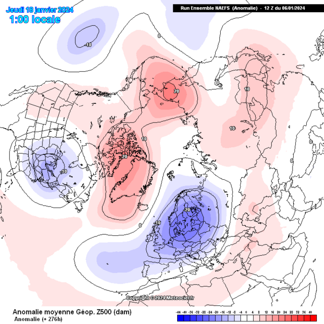
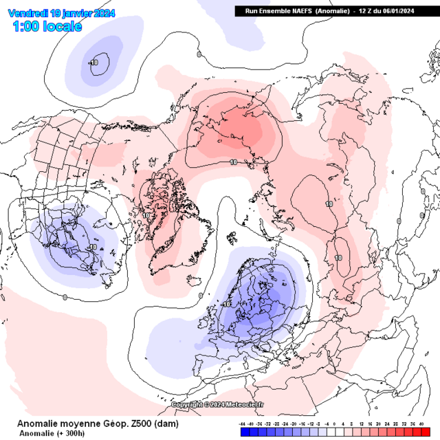
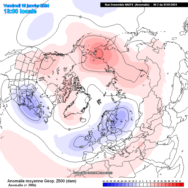
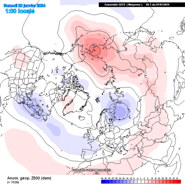
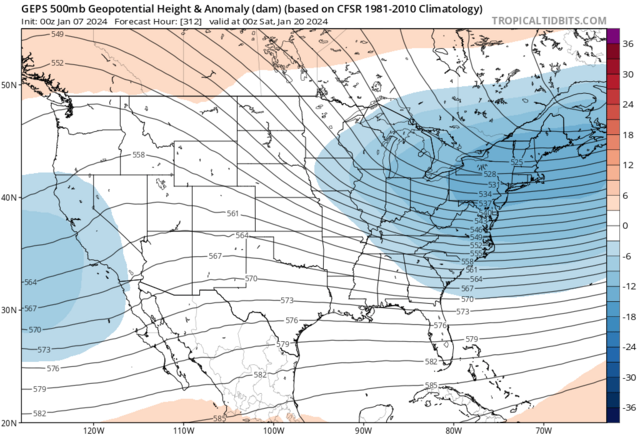
Super happy with the evolution since Late December now its becoming clearer in some finer detailing of this upcoming significant cold episode.
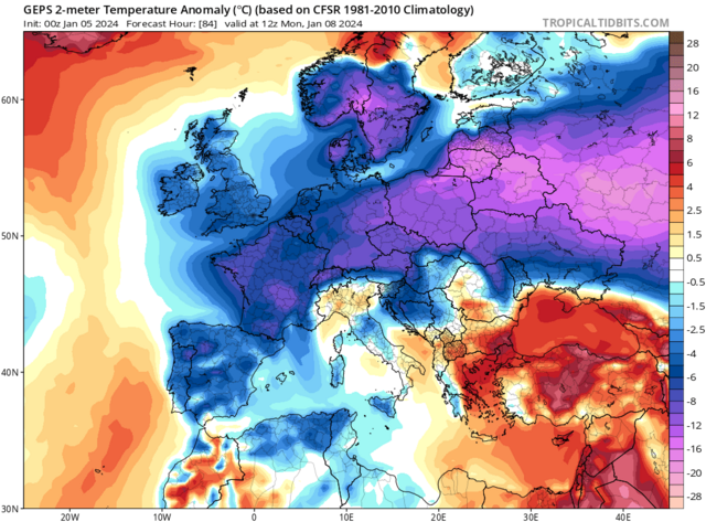
- Significant cold front moving south bringing significant below avg surface and 850hpa temperature anomalies by Sunday January 14th
- Surface temperatures point to a severe winter weather event.
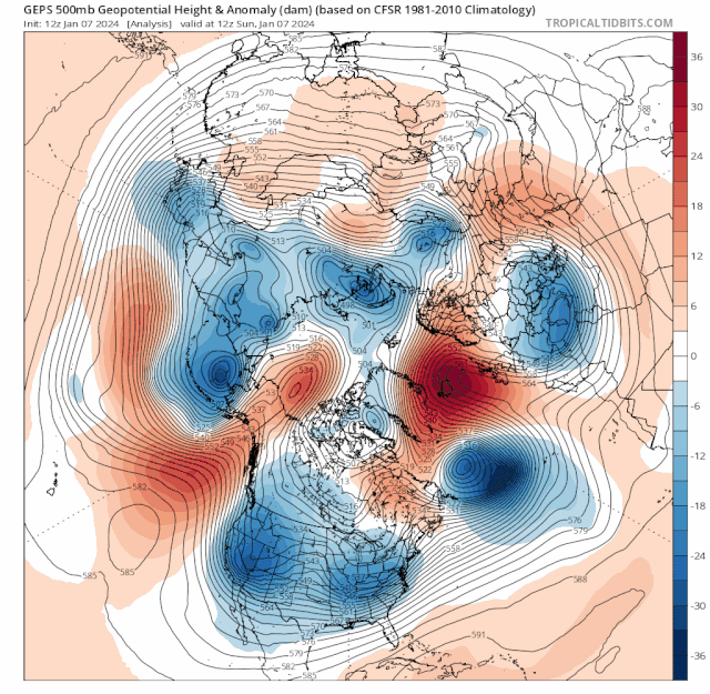
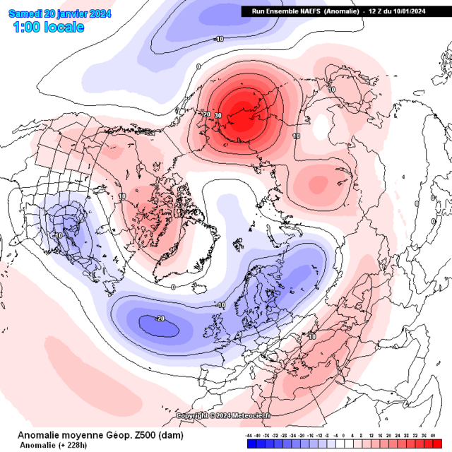
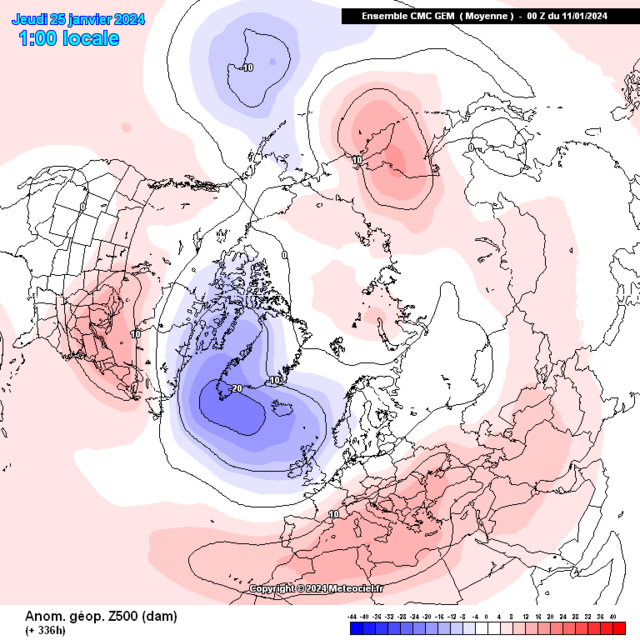
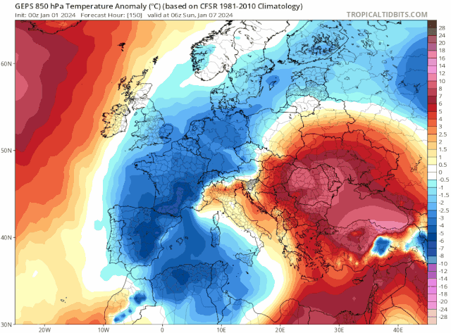
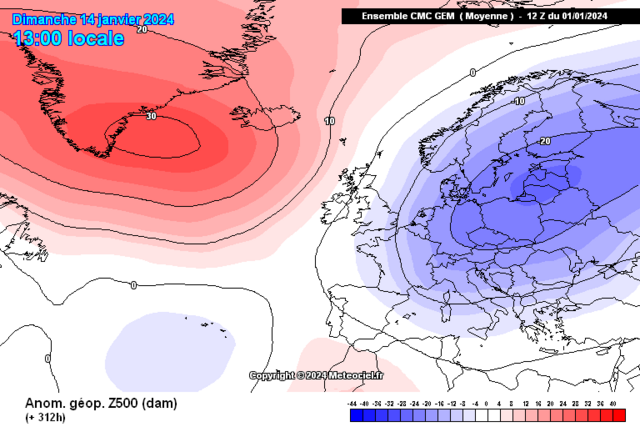
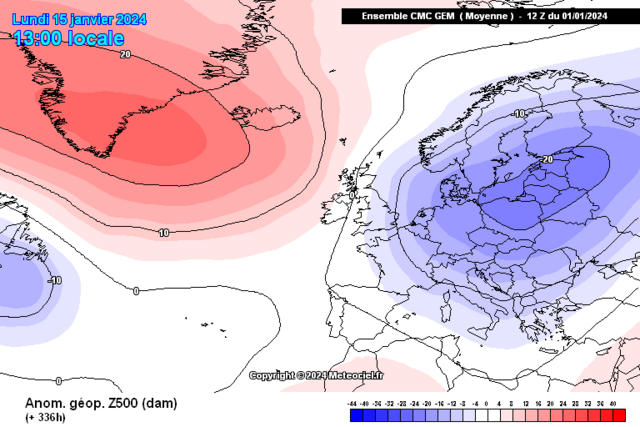
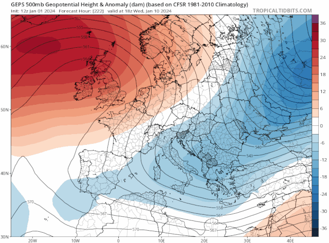
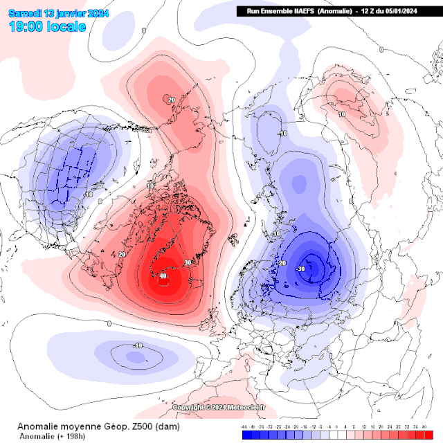
"Through Jan week 2 toward the aforementioned middle month period we'll have the -NAO,-AO,PNA,El Ninò,MJO and Easterly QBO feeding towards the setup going retrogressive this will have a couple of significant changes with a westwards moving trough which links with expectations into elongation with the centre over the Baltics, Scandinavia as this is occuring the high pressure and block will shift northwestward to reside across Greenland this is more supporting of colder 850hpa temps likely from the Northeast, we maintain below average surface temps during this with possible scope for these to get colder"
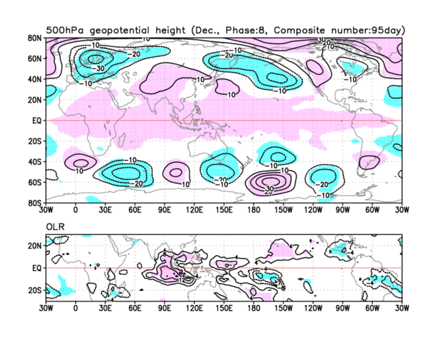
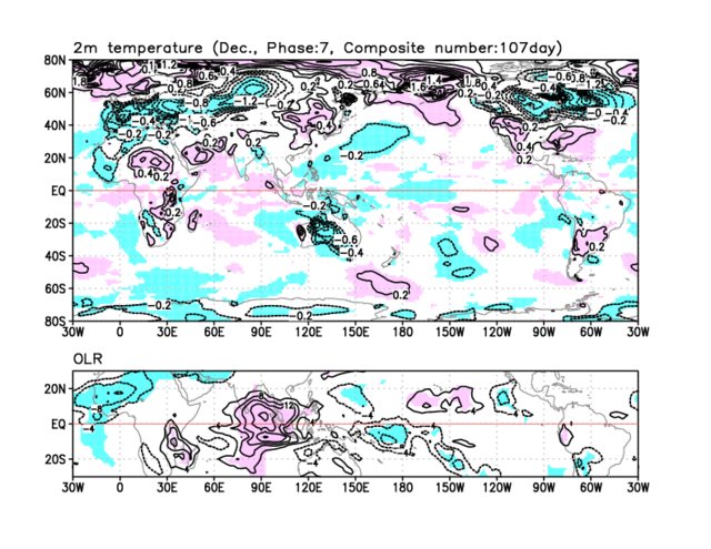
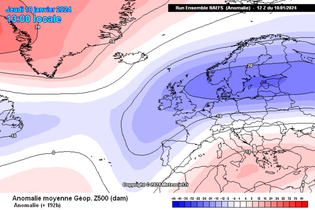
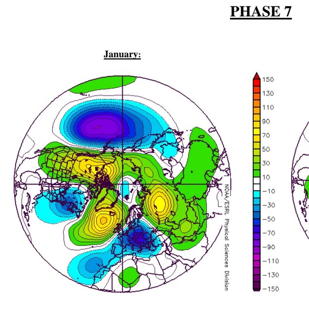
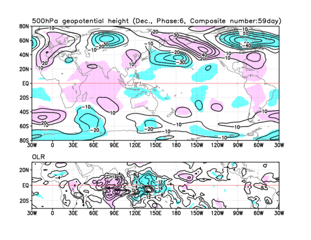
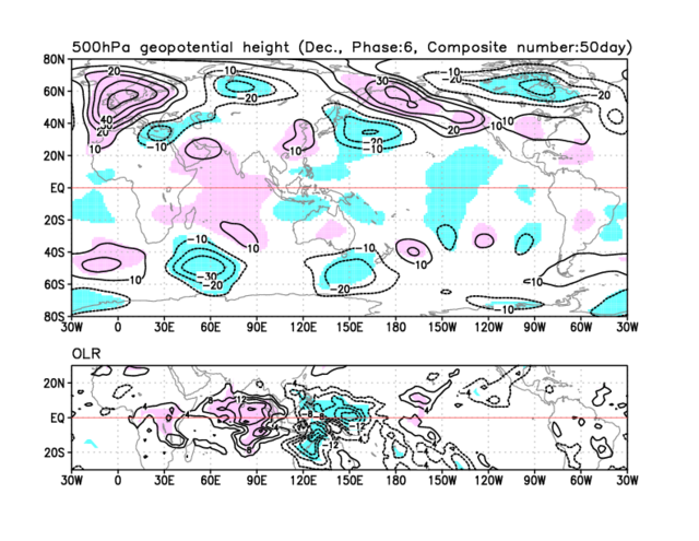
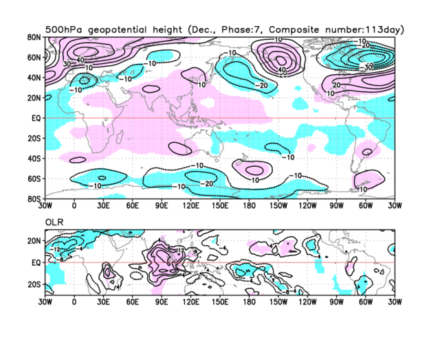
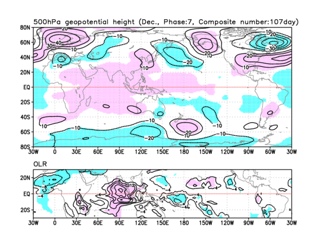
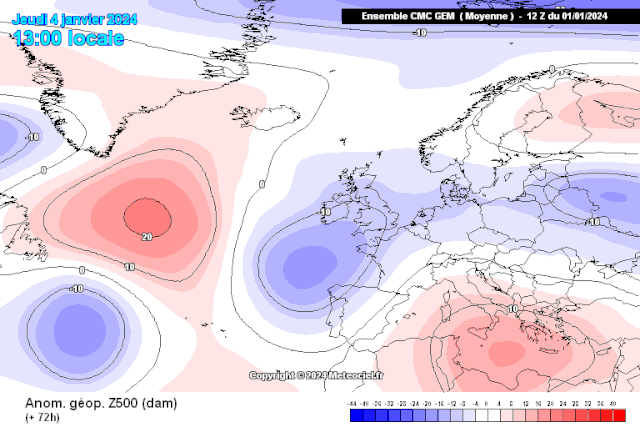
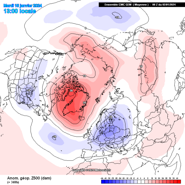
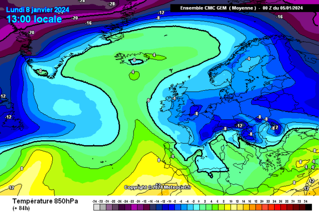
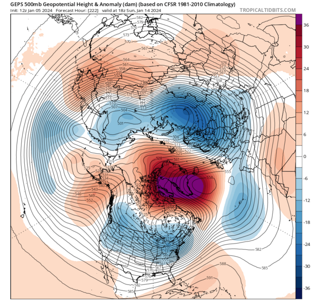
'Seeing the heart of these colder temperatures at surface and upper level becoming centred through Europe with just the far south of the UK clinging to is perfectly anticipated thanks to the phase 7 feedback'
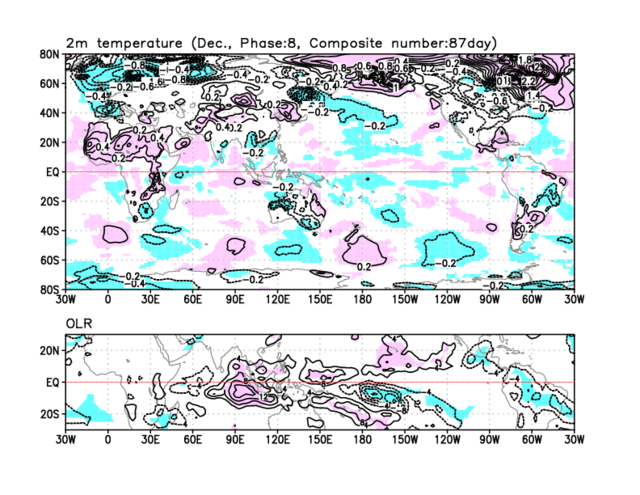
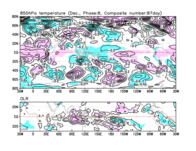
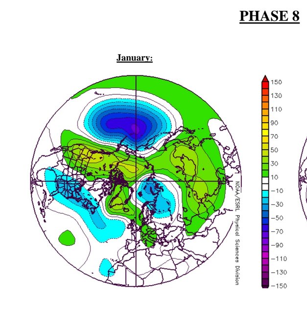
Note the movement northwards of this cold anomaly from phases 7 into 8
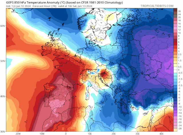
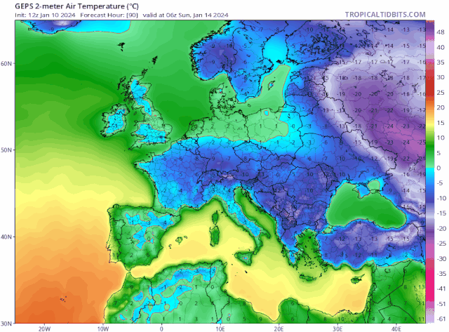
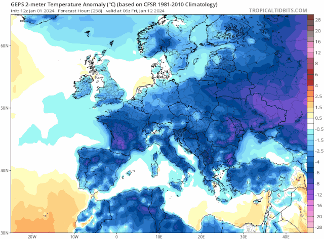
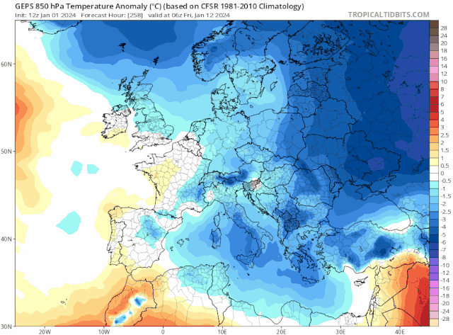
From the above we can Note the significance of both 850hpa temps and in particular surface temperatures as both will contain anomalies roughly 15 > 20 Degrees BELOW AVERAGE, this will give multiple ice days in succession with liklihood of significant ice days over Scotland and Northern regions of England though there will be ice days for Ireland


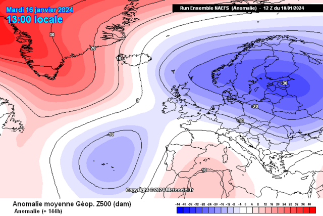
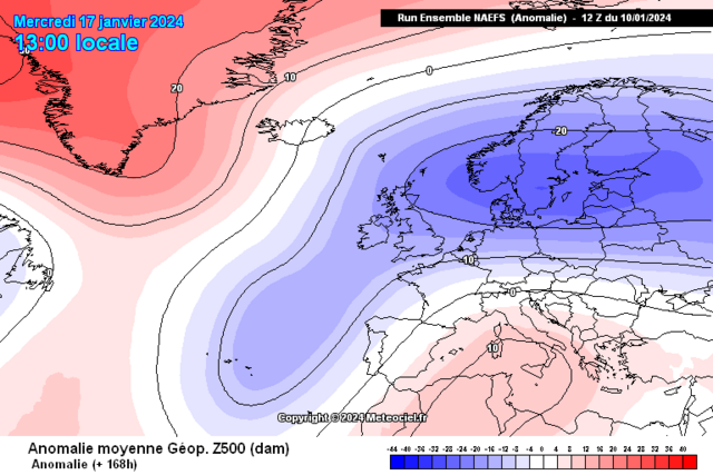
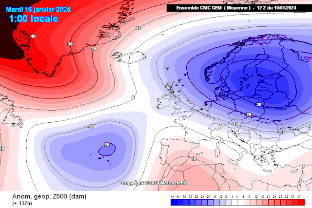
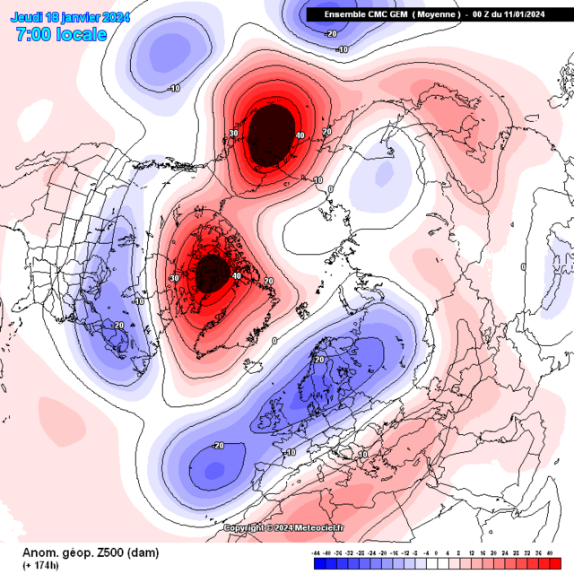
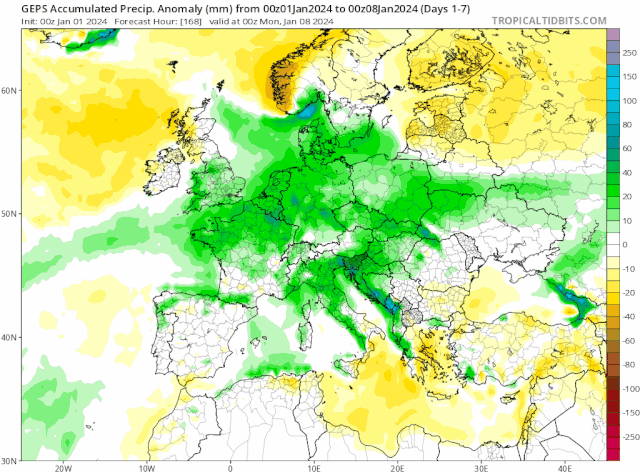
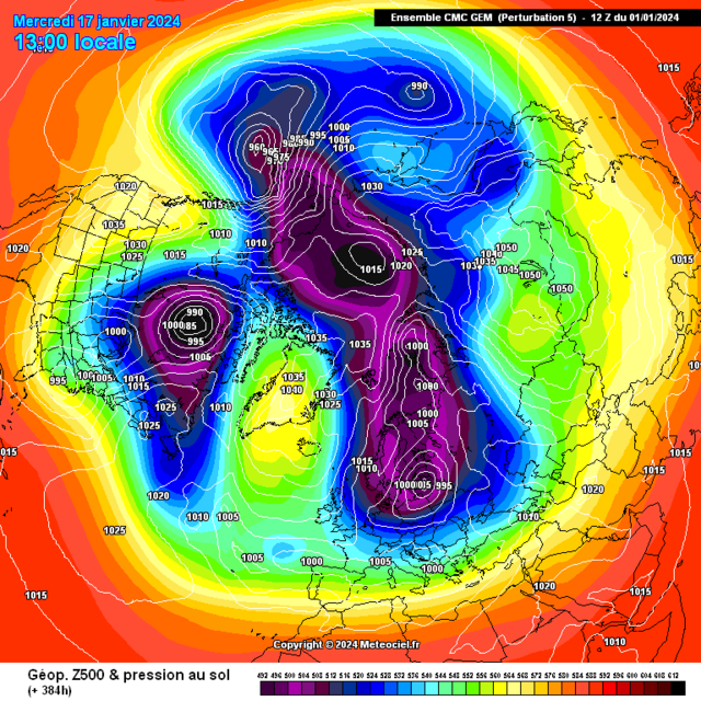
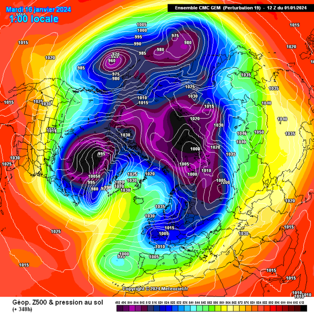
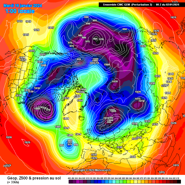
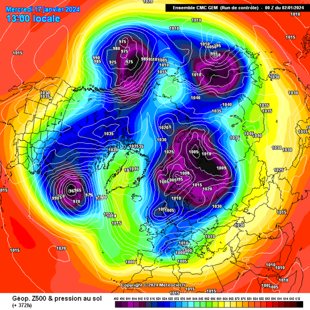
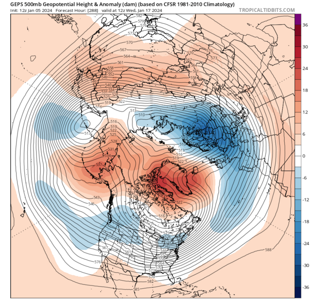
A timeframe with a focal point towards wintry precip event(s) will be from January 16th through 18th with the cyclone in the Atlantic starting the merging process to the Scandinavian Baltic Trough
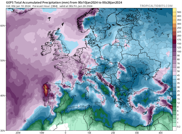
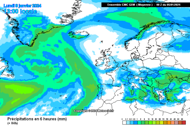
7 day precip anomaly. I'm expectant of significant flash flood event[s] for Portugal and its border into Northwest Spain
Such an excellent showcase of all the teleconnective feedback coming into one stunning meteorological display


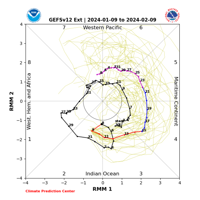
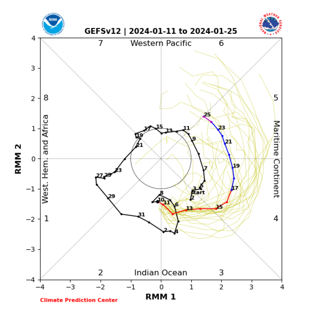
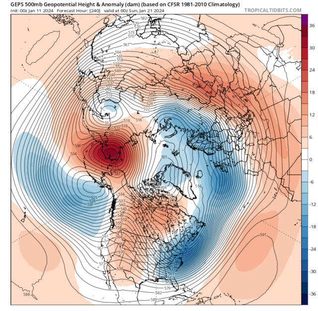
"My thinking holds steady with the MJO working into the Maritimes generally Mid Jan maybe into January week 3 as this increases cyclonic developments seeing these sorts of 500hpa setups during that period is very plausible.''
Following the MJO passing across the Maritimes we begin seeing feedback of phases 1 and into 2 as January week 4 gets started a high forms toward the Maritimes which might extend through Canada, also I'm starting to notice the trend toward cut off low development toward Mexico, far Southwest US

Original post: https://community.netweather.tv/topic/99760-model-output-discussion-colder-but-how-cold-and-for-how-long/?do=findComment&comment=5007007-
1
-
 1
1
-
- Popular Post
16 hours ago, Huntforsnow said:We haven’t heard from @Kirkcaldy Weather in a while
 2 minutes ago, Kirkcaldy Weather said:
Super happy with the evolution since Late December now its becoming clearer in some finer detailing of this upcoming significant cold episode.
- Significant cold front moving south bringing significant below avg surface and 850hpa temperature anomalies by Sunday January 14th
- Surface temperatures point to a severe winter weather event.
"Through Jan week 2 toward the aforementioned middle month period we'll have the -NAO,-AO,PNA,El Ninò,MJO and Easterly QBO feeding towards the setup going retrogressive this will have a couple of significant changes with a westwards moving trough which links with expectations into elongation with the centre over the Baltics, Scandinavia as this is occuring the high pressure and block will shift northwestward to reside across Greenland this is more supporting of colder 850hpa temps likely from the Northeast, we maintain below average surface temps during this with possible scope for these to get colder"
'Seeing the heart of these colder temperatures at surface and upper level becoming centred through Europe with just the far south of the UK clinging to is perfectly anticipated thanks to the phase 7 feedback'
Note the movement northwards of this cold anomaly from phases 7 into 8
From the above we can Note the significance of both 850hpa temps and in particular surface temperatures as both will contain anomalies roughly 15 > 20 Degrees BELOW AVERAGE, this will give multiple ice days in succession with liklihood of significant ice days over Scotland and Northern regions of England though there will be ice days for Ireland
A timeframe with a focal point towards wintry precip event(s) will be from January 16th through 18th with the cyclone in the Atlantic starting the merging process to the Scandinavian Baltic Trough
7 day precip anomaly. I'm expectant of significant flash flood event[s] for Portugal and its border into Northwest Spain
Such an excellent showcase of all the teleconnective feedback coming into one stunning meteorological display
"My thinking holds steady with the MJO working into the Maritimes generally Mid Jan maybe into January week 3 as this increases cyclonic developments seeing these sorts of 500hpa setups during that period is very plausible.''
Following the MJO passing across the Maritimes we begin seeing feedback of phases 1 and into 2 as January week 4 gets started a high forms toward the Maritimes which might extend through Canada, also I'm starting to notice the trend toward cut off low development toward Mexico, far Southwest US


-
13
-
 2
2
-
1
-
- Popular Post
- Popular Post
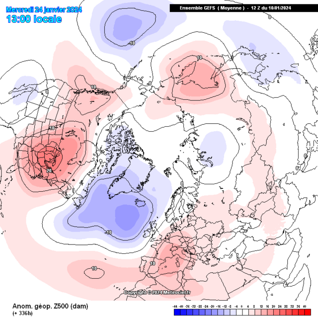
Super happy with the evolution since Late December now its becoming clearer in some finer detailing of this upcoming significant cold episode.
- Significant cold front moving south bringing significant below avg surface and 850hpa temperature anomalies by Sunday January 14th
- Surface temperatures point to a severe winter weather event.
"Through Jan week 2 toward the aforementioned middle month period we'll have the -NAO,-AO,PNA,El Ninò,MJO and Easterly QBO feeding towards the setup going retrogressive this will have a couple of significant changes with a westwards moving trough which links with expectations into elongation with the centre over the Baltics, Scandinavia as this is occuring the high pressure and block will shift northwestward to reside across Greenland this is more supporting of colder 850hpa temps likely from the Northeast, we maintain below average surface temps during this with possible scope for these to get colder"
'Seeing the heart of these colder temperatures at surface and upper level becoming centred through Europe with just the far south of the UK clinging to is perfectly anticipated thanks to the phase 7 feedback'
Note the movement northwards of this cold anomaly from phases 7 into 8
From the above we can Note the significance of both 850hpa temps and in particular surface temperatures as both will contain anomalies roughly 15 > 20 Degrees BELOW AVERAGE, this will give multiple ice days in succession with liklihood of significant ice days over Scotland and Northern regions of England though there will be ice days for Ireland
A timeframe with a focal point towards wintry precip event(s) will be from January 16th through 18th with the cyclone in the Atlantic starting the merging process to the Scandinavian Baltic Trough
7 day precip anomaly. I'm expectant of significant flash flood event[s] for Portugal and its border into Northwest Spain
Such an excellent showcase of all the teleconnective feedback coming into one stunning meteorological display
"My thinking holds steady with the MJO working into the Maritimes generally Mid Jan maybe into January week 3 as this increases cyclonic developments seeing these sorts of 500hpa setups during that period is very plausible.''
Following the MJO passing across the Maritimes we begin seeing feedback of phases 1 and into 2 as January week 4 gets started a high forms toward the Maritimes which might extend through Canada, also I'm starting to notice the trend toward cut off low development toward Mexico, far Southwest US
-
6
-
5
-
13
-
-
-
-
-
On 02/01/2024 at 14:35, Kirkcaldy Weather said:
First off I'd like to wish you all a happy new year


Leading onto my prior post(s)
This week is the beginning of the expected 500hpa shifts with a Rossby Wave Break which takes a low from the UK down into Italy and begins the switch toward what is known as a 'Southerly tracking Jet'
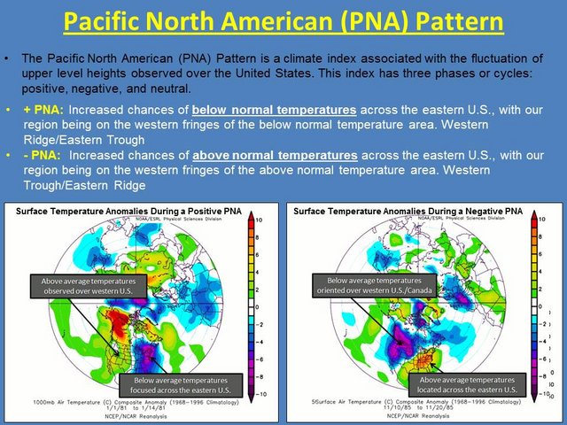
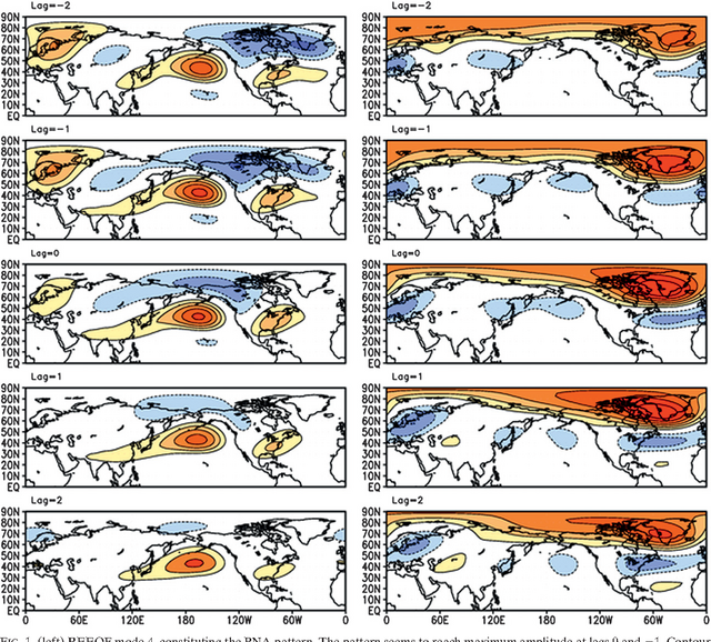
I've always remained focused into January week 2 for the shift to a colder pattern, I expect the first major talking point is the ongoing negative PNA coming into the 500hpa pattern
This causes a trough to take shape over the Western US which looks like having an opportunity to threaten cold temperature records and with the low pressure setting up I wouldn't be surprised for significant snow in this region
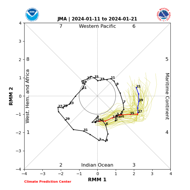
For the UK as the -PNA feedback paired to the MJO feedback covered in my previous post develops this sees high pressure and blocking being the main influence at least for a time more on that below, all the relevant 500hpa composites are covered in my prior post however using the JMA MJO evolution covers it / simplifies it rather well for learners etc

Starting with the Southerly tracking Jet & trough plus the build in heights through and North of the UK
So with the -PNA and MJO feedback being at the forefront we see the below average temperatures begin as we go into January week 2
With this stage of proceedings dominated by higher pressure this will bring drier than average conditions and you'll also be able to watch the Jet becoming directed increasingly further south as discussed.
With this being high pressure in control during this period this equates to 850hpa temps above average particularly closest to the highs centre ie North UK and to the North of the UK
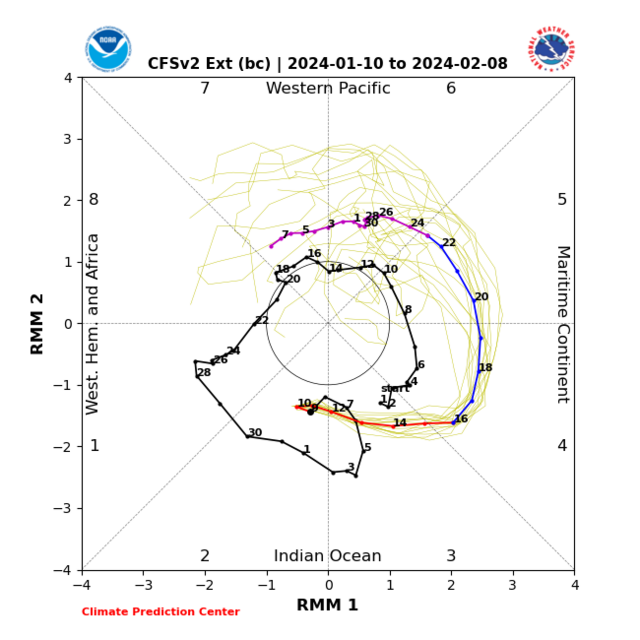
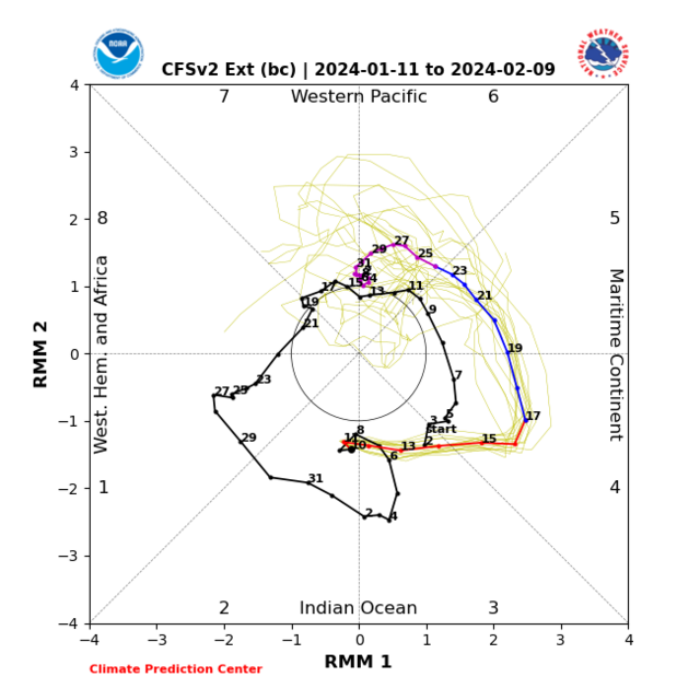
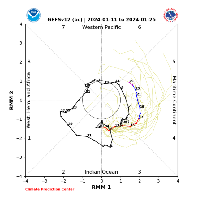
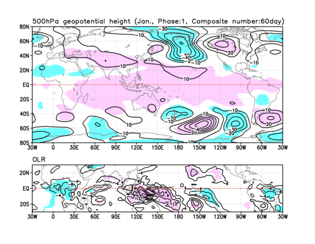
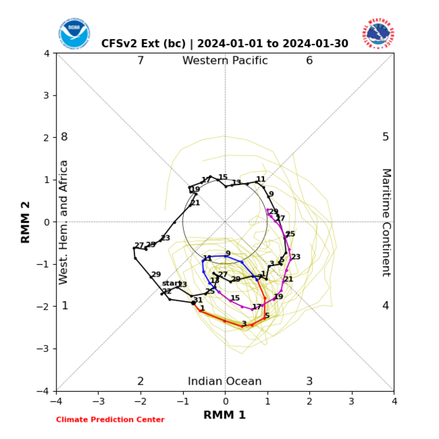
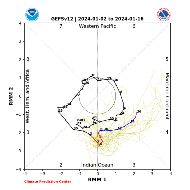
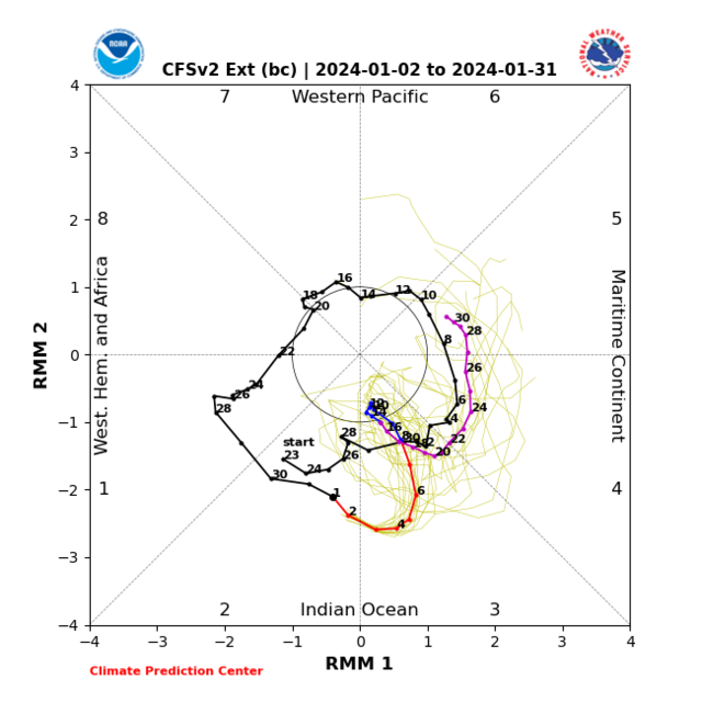
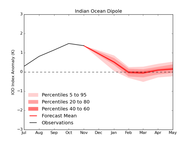
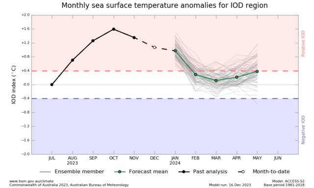
Now lets dive into the MJO because it carries importance at various levels. This cycle across the Indian Ocean is likely THE one which begins and coincides with the positive Indian Ocean Dipole event which is still gradually weakening however now begins to do so in a more dramatic fashion compared to the slowish weakening from October
Not shocking to be seeing some further interfering into the MJO's progress over the IO in particular the CFS expecting that more so than the GEFS and GFS, This could have some impact with regard to an important evolution of the cyclonic developments across Canada into the Maritimes I'd still favour mid Jan but might be slightly later should we get the interference a la the CFS.
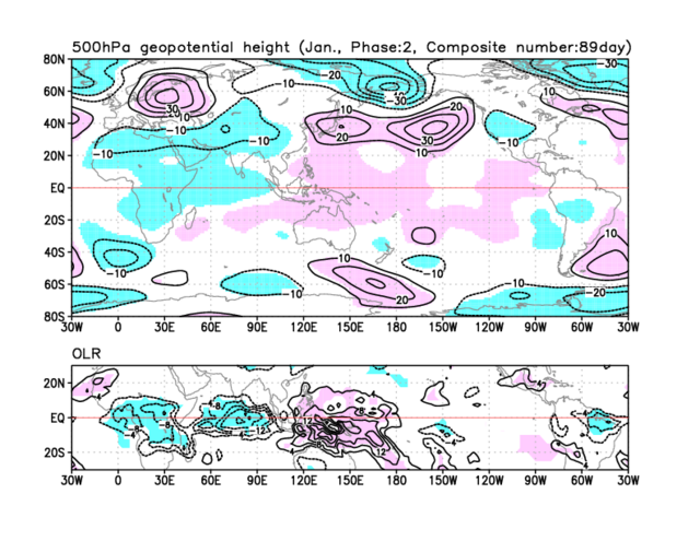
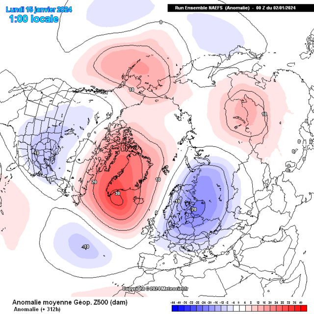
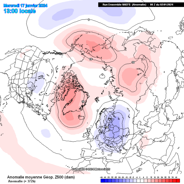
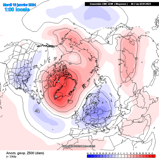
Through Jan week 2 toward the aforementioned middle month period we'll have the -NAO,-AO,PNA,El Ninò,MJO and Easterly QBO feeding towards the setup going retrogressive this will have a couple of significant changes with a westwards moving trough which links with expectations into elongation with the centre over the Baltics, Scandinavia as this is occuring the high pressure and block will shift northwestward to reside across Greenland this is more supporting of colder 850hpa temps likely from the Northeast, we maintain below average surface temps during this with possible scope for these to get colder
My thinking holds steady with the MJO working into the Maritimes generally Mid Jan maybe into January week 3 as this increases cyclonic developments seeing these sorts of 500hpa setups during that period is very plausible.
These 500hpa setups also once more continue being prominent in the precursors which have been most effective in leading to weaker Vortex and potential further stratospheric warming(s)
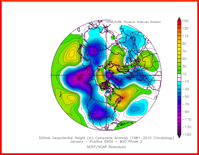
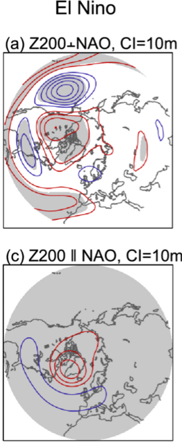
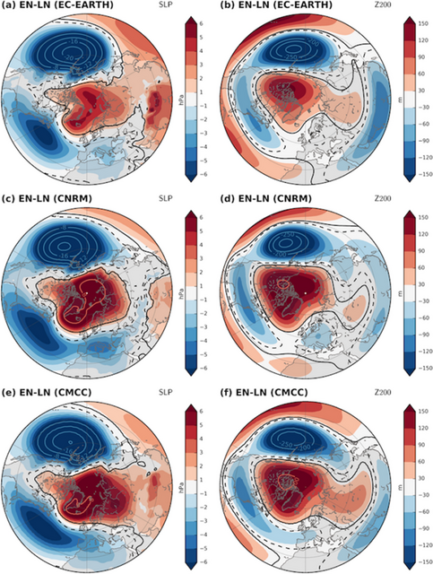
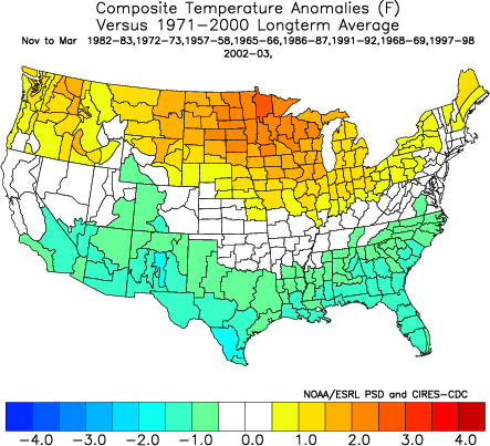
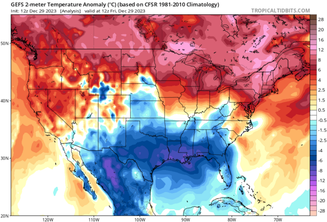
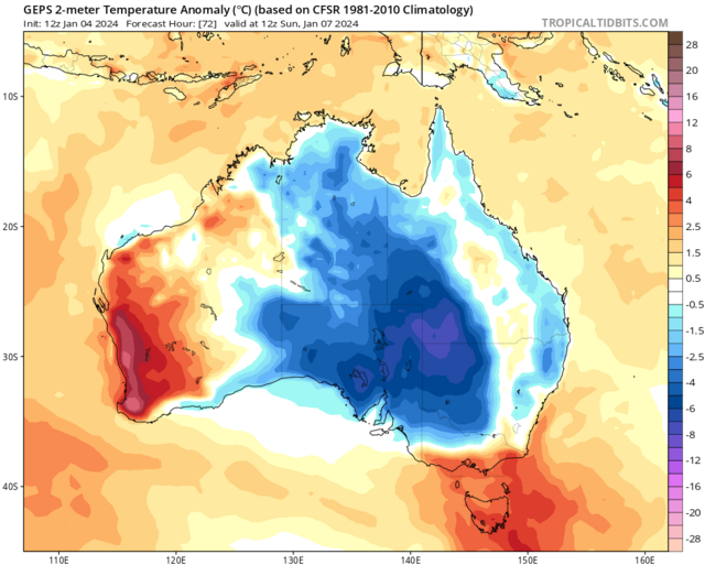
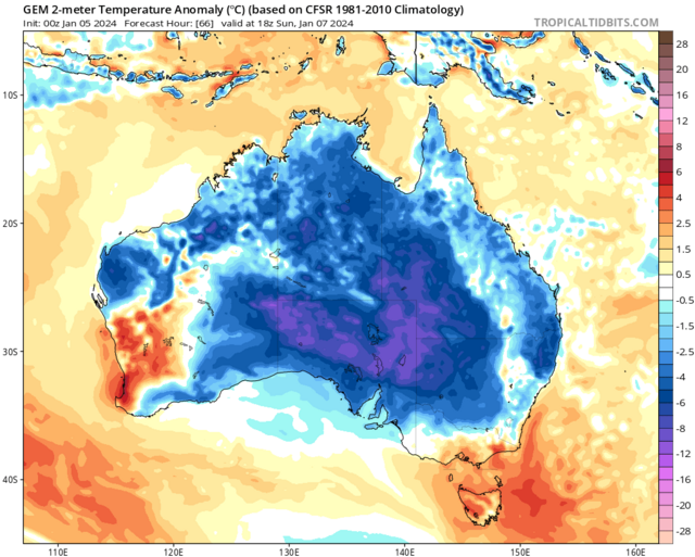
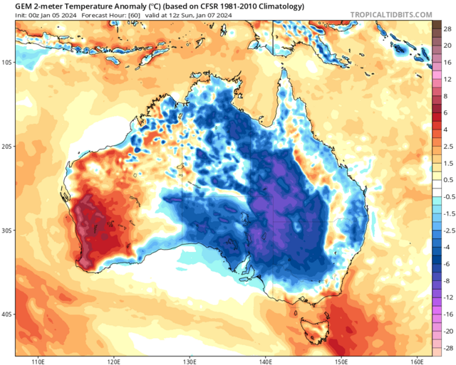
Wonderful showcase of El Ninò surface temperature patterns during winter on the go of late in America
On 05/01/2024 at 20:02, Kirkcaldy Weather said:Into the start of January week 2 which is Monday we'll have some supportive upper level ingredients giving a chance of snow streamer development on the southern end of the block across the UK and North Sea. This time period never had a focal point towards an abundance of wintry precipitation and snow as explained
Seeing the heart of these colder temperatures at surface and upper level becoming centred through Europe with just the far south of the UK clinging to is perfectly anticipated thanks to the phase 7 feedback which also gives a swathe of Australia
 Central also colder than average conditions
At the moment we're looking at the latter stage of Jan week 2 MIDMONTH through about 5>6 days for the coldest surface and 850hpa temps
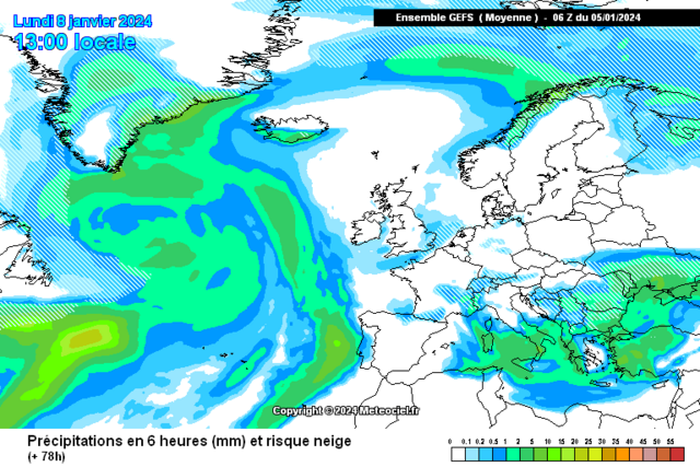
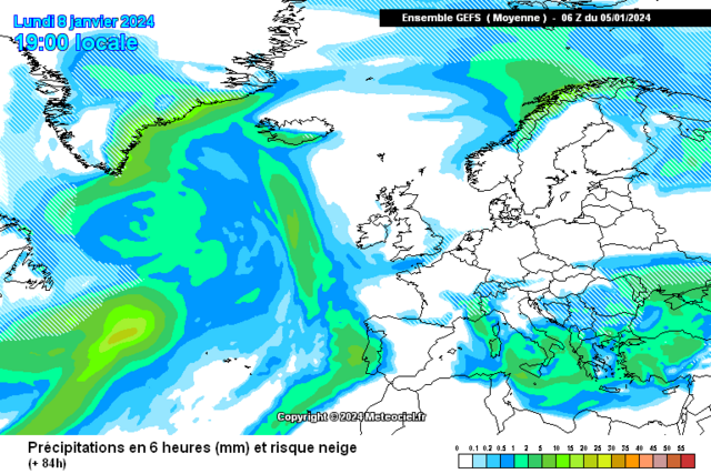
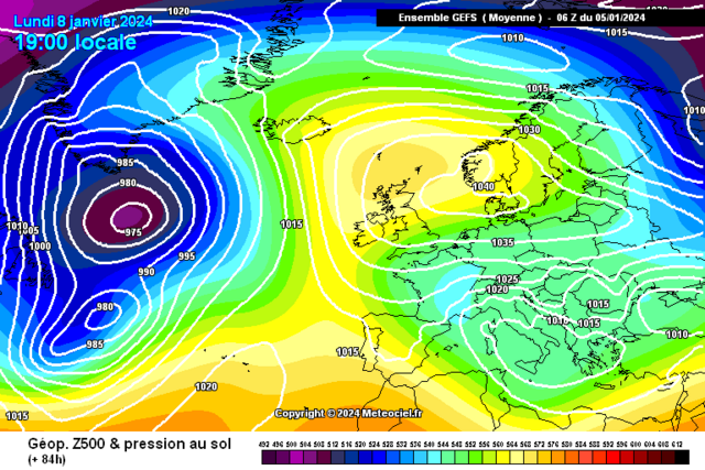
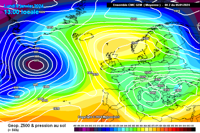
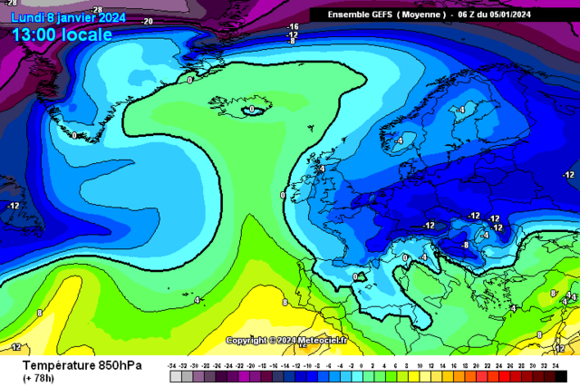
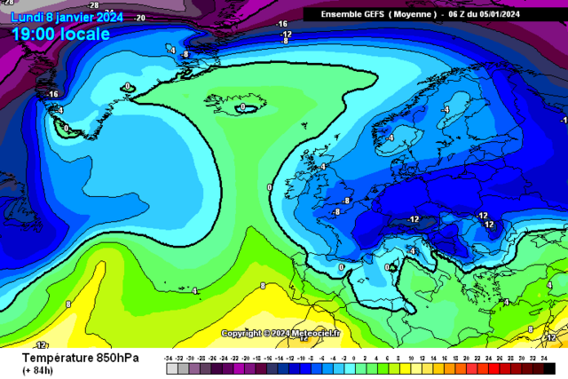
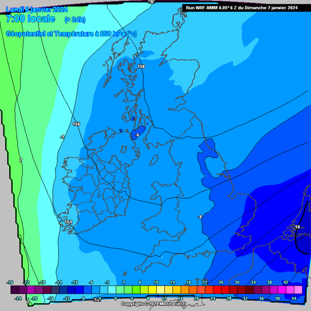
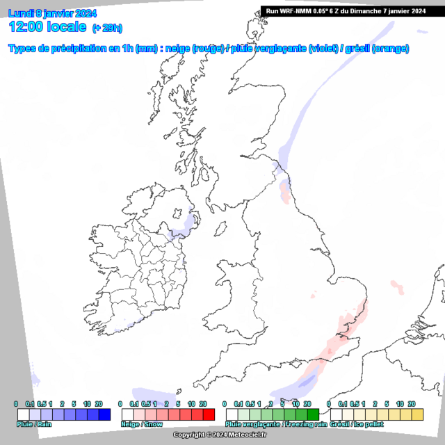
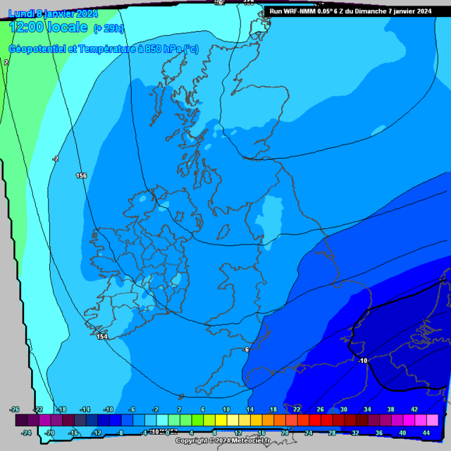
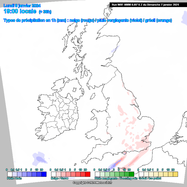
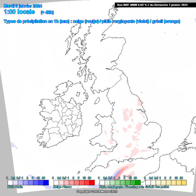
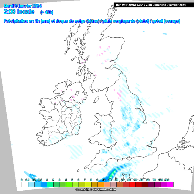
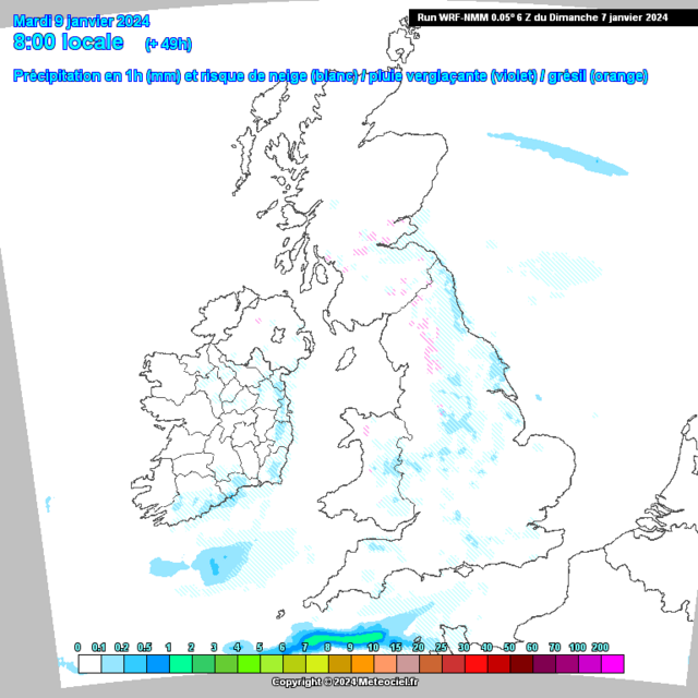
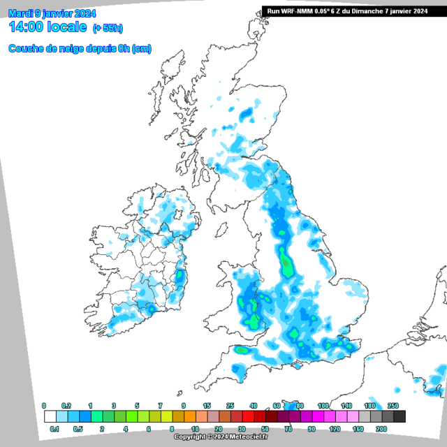
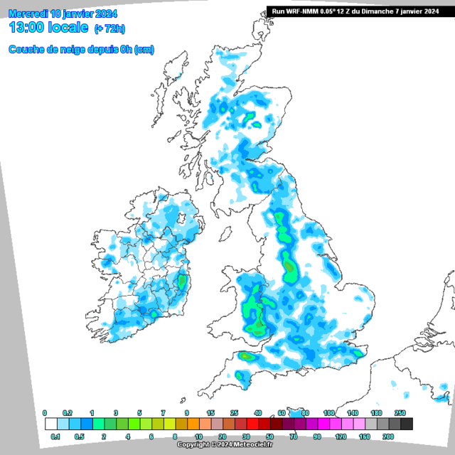
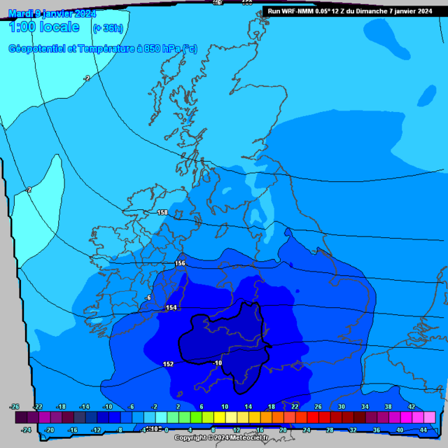
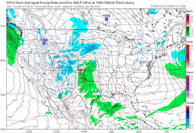
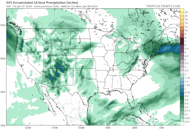
19 hours ago, Kirkcaldy Weather said:The snow streamer development will get going into early Monday Jan 8th as -8 850hpa temps move into Southeast England
Come Monday Afternoon this snow streamer will begin to have increasing snowfall rates as a cold pool starts to form over Southeast England with 850hpa temperatures intensifying to -10
As this setup gradually moves westward this will have snow showers development further north & northwest of this streamer
Upper dynamics further north northwest won't be as supporting for purely snow so precip here will see mixing including freezing rain.
By Tuesday and Weds a large swathe of the UK and Ireland have a good liklihood of having received at least a dusting, somewhat bigger amounts over higher terrain.
Here's charts to save particularly for members in the Southwest and South Southeast Ireland with a -10 850hpa cold pool
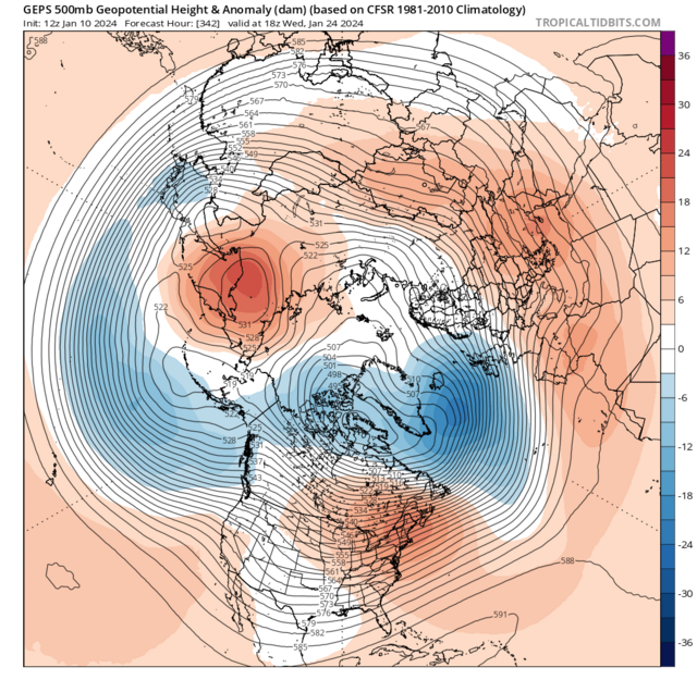
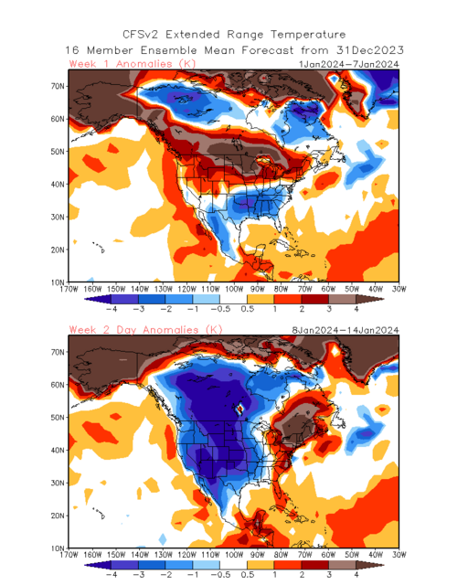
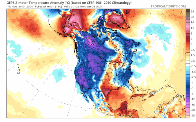
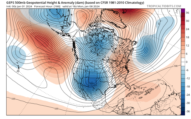
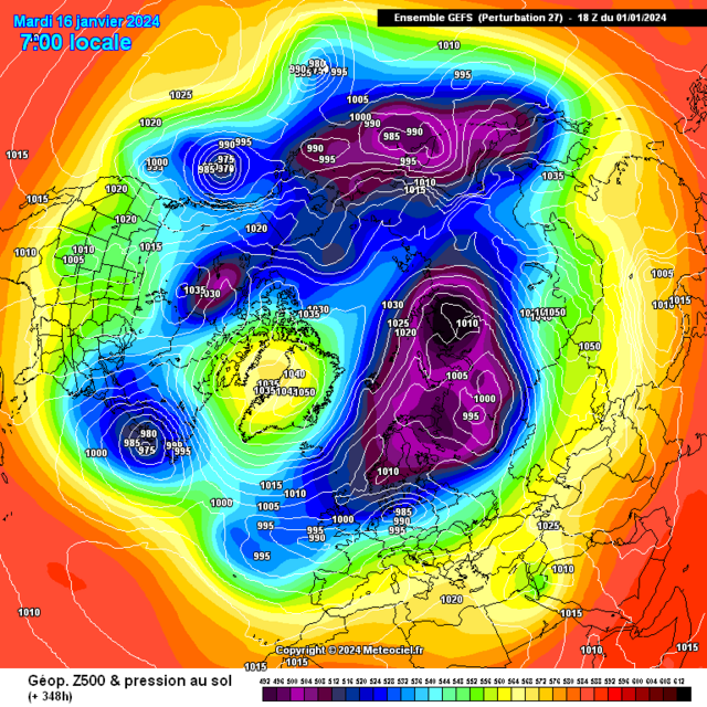
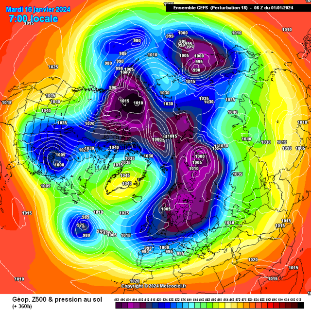
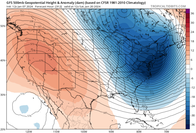
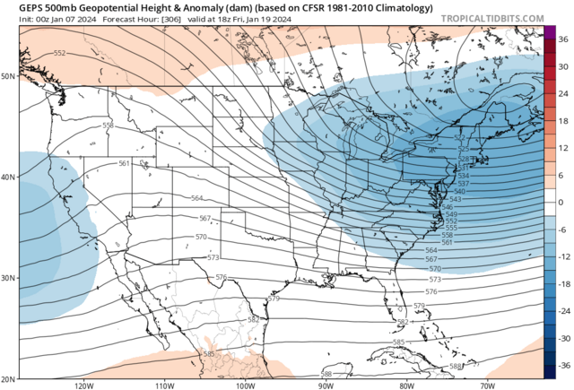
On track with this as the major focal points are the deep cold focused especially ocer the west and northwest of the states in association to the -PNA.
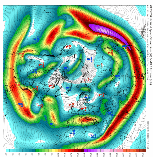
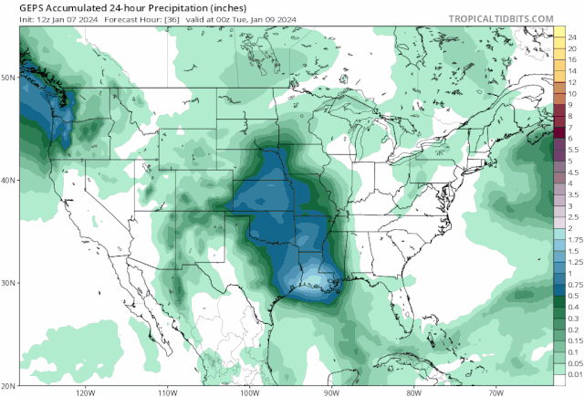
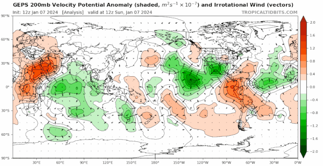
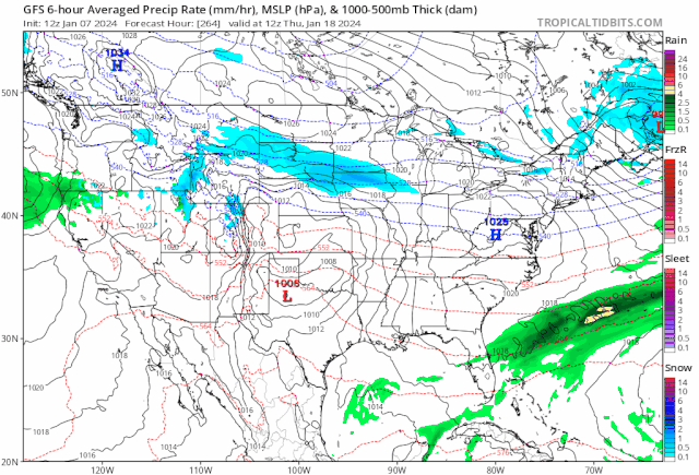
We're watching the feedback of recent MJO phases paired with the Ninò style jet as discussed in length on my recent posts, first a major storm by Tuesday 9th Jan into Wednesday 10th Jan with a blizzard on its North and Northwest flank and further flash flooding and severe weather potential (tornadic) on the Southern and Southeast flank
This is the 1st of Three systems during Jan week 2 with the next two being centred a tad further south again as the Ninò Jet adjusts
The 200mb velocity reflects this very nice

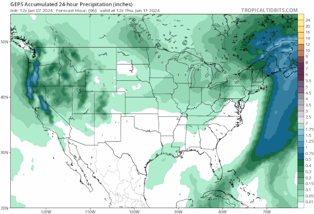
Again links with recent MJO phases this links with the PNA heading more into positive territory, door opens for a snowy system into Northeast America from roughly Jan 18th - 21st IMO
 ️
️
-
On 05/01/2024 at 20:02, Kirkcaldy Weather said:
Into the start of January week 2 which is Monday we'll have some supportive upper level ingredients giving a chance of snow streamer development on the southern end of the block across the UK and North Sea. This time period never had a focal point towards an abundance of wintry precipitation and snow as explained
Seeing the heart of these colder temperatures at surface and upper level becoming centred through Europe with just the far south of the UK clinging to is perfectly anticipated thanks to the phase 7 feedback which also gives a swathe of Australia
Central also colder than average conditions
At the moment we're looking at the latter stage of Jan week 2 MIDMONTH through about 5>6 days for the coldest surface and 850hpa temps
The snow streamer development will get going into early Monday Jan 8th as -8 850hpa temps move into Southeast England
Come Monday Afternoon this snow streamer will begin to have increasing snowfall rates as a cold pool starts to form over Southeast England with 850hpa temperatures intensifying to -10
As this setup gradually moves westward this will have snow showers development further north & northwest of this streamer
Upper dynamics further north northwest won't be as supporting for purely snow so precip here will see mixing including freezing rain.
By Tuesday and Weds a large swathe of the UK and Ireland have a good liklihood of having received at least a dusting, somewhat bigger amounts over higher terrain.
Here's charts to save particularly for members in the Southwest and South Southeast Ireland with a -10 850hpa cold pool
On 02/01/2024 at 14:35, Kirkcaldy Weather said:First off I'd like to wish you all a happy new year
Leading onto my prior post(s)
This week is the beginning of the expected 500hpa shifts with a Rossby Wave Break which takes a low from the UK down into Italy and begins the switch toward what is known as a 'Southerly tracking Jet'
I've always remained focused into January week 2 for the shift to a colder pattern, I expect the first major talking point is the ongoing negative PNA coming into the 500hpa pattern
This causes a trough to take shape over the Western US which looks like having an opportunity to threaten cold temperature records and with the low pressure setting up I wouldn't be surprised for significant snow in this region
For the UK as the -PNA feedback paired to the MJO feedback covered in my previous post develops this sees high pressure and blocking being the main influence at least for a time more on that below, all the relevant 500hpa composites are covered in my prior post however using the JMA MJO evolution covers it / simplifies it rather well for learners etc
Starting with the Southerly tracking Jet & trough plus the build in heights through and North of the UK
So with the -PNA and MJO feedback being at the forefront we see the below average temperatures begin as we go into January week 2
With this stage of proceedings dominated by higher pressure this will bring drier than average conditions and you'll also be able to watch the Jet becoming directed increasingly further south as discussed.
With this being high pressure in control during this period this equates to 850hpa temps above average particularly closest to the highs centre ie North UK and to the North of the UK
Now lets dive into the MJO because it carries importance at various levels. This cycle across the Indian Ocean is likely THE one which begins and coincides with the positive Indian Ocean Dipole event which is still gradually weakening however now begins to do so in a more dramatic fashion compared to the slowish weakening from October
Not shocking to be seeing some further interfering into the MJO's progress over the IO in particular the CFS expecting that more so than the GEFS and GFS, This could have some impact with regard to an important evolution of the cyclonic developments across Canada into the Maritimes I'd still favour mid Jan but might be slightly later should we get the interference a la the CFS.
Through Jan week 2 toward the aforementioned middle month period we'll have the -NAO,-AO,PNA,El Ninò,MJO and Easterly QBO feeding towards the setup going retrogressive this will have a couple of significant changes with a westwards moving trough which links with expectations into elongation with the centre over the Baltics, Scandinavia as this is occuring the high pressure and block will shift northwestward to reside across Greenland this is more supporting of colder 850hpa temps likely from the Northeast, we maintain below average surface temps during this with possible scope for these to get colder
My thinking holds steady with the MJO working into the Maritimes generally Mid Jan maybe into January week 3 as this increases cyclonic developments seeing these sorts of 500hpa setups during that period is very plausible.
These 500hpa setups also once more continue being prominent in the precursors which have been most effective in leading to weaker Vortex and potential further stratospheric warming(s)
Wonderful showcase of El Ninò surface temperature patterns during winter on the go of late in America
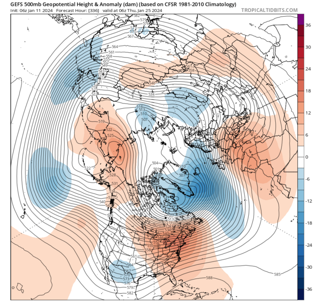
On track with this as the major focal points are the deep cold focused especially ocer the west and northwest of the states in association to the -PNA.
We're watching the feedback of recent MJO phases paired with the Ninò style jet as discussed in length on my recent posts, first a major storm by Tuesday 9th Jan into Wednesday 10th Jan with a blizzard on its North and Northwest flank and further flash flooding and severe weather potential (tornadic) on the Southern and Southeast flank
This is the 1st of Three systems during Jan week 2 with the next two being centred a tad further south again as the Ninò Jet adjusts
The 200mb velocity reflects this very nice
Again links with recent MJO phases this links with the PNA heading more into positive territory, door opens for a snowy system into Northeast America from roughly Jan 18th - 21st IMO
️
Original post: https://community.netweather.tv/topic/99706-model-output-discussion-into-2024/?do=findComment&comment=5000090-
3
-
-
- Popular Post
- Popular Post
On 05/01/2024 at 20:02, Kirkcaldy Weather said:Into the start of January week 2 which is Monday we'll have some supportive upper level ingredients giving a chance of snow streamer development on the southern end of the block across the UK and North Sea. This time period never had a focal point towards an abundance of wintry precipitation and snow as explained
Seeing the heart of these colder temperatures at surface and upper level becoming centred through Europe with just the far south of the UK clinging to is perfectly anticipated thanks to the phase 7 feedback which also gives a swathe of Australia
Central also colder than average conditions
At the moment we're looking at the latter stage of Jan week 2 MIDMONTH through about 5>6 days for the coldest surface and 850hpa temps
The snow streamer development will get going into early Monday Jan 8th as -8 850hpa temps move into Southeast England
Come Monday Afternoon this snow streamer will begin to have increasing snowfall rates as a cold pool starts to form over Southeast England with 850hpa temperatures intensifying to -10
As this setup gradually moves westward this will have snow showers development further north & northwest of this streamer
Upper dynamics further north northwest won't be as supporting for purely snow so precip here will see mixing including freezing rain.
By Tuesday and Weds a large swathe of the UK and Ireland have a good liklihood of having received at least a dusting, somewhat bigger amounts over higher terrain.
Here's charts to save particularly for members in the Southwest and South Southeast Ireland with a -10 850hpa cold pool
On 02/01/2024 at 14:35, Kirkcaldy Weather said:First off I'd like to wish you all a happy new year
Leading onto my prior post(s)
This week is the beginning of the expected 500hpa shifts with a Rossby Wave Break which takes a low from the UK down into Italy and begins the switch toward what is known as a 'Southerly tracking Jet'
I've always remained focused into January week 2 for the shift to a colder pattern, I expect the first major talking point is the ongoing negative PNA coming into the 500hpa pattern
This causes a trough to take shape over the Western US which looks like having an opportunity to threaten cold temperature records and with the low pressure setting up I wouldn't be surprised for significant snow in this region
For the UK as the -PNA feedback paired to the MJO feedback covered in my previous post develops this sees high pressure and blocking being the main influence at least for a time more on that below, all the relevant 500hpa composites are covered in my prior post however using the JMA MJO evolution covers it / simplifies it rather well for learners etc
Starting with the Southerly tracking Jet & trough plus the build in heights through and North of the UK
So with the -PNA and MJO feedback being at the forefront we see the below average temperatures begin as we go into January week 2
With this stage of proceedings dominated by higher pressure this will bring drier than average conditions and you'll also be able to watch the Jet becoming directed increasingly further south as discussed.
With this being high pressure in control during this period this equates to 850hpa temps above average particularly closest to the highs centre ie North UK and to the North of the UK
Now lets dive into the MJO because it carries importance at various levels. This cycle across the Indian Ocean is likely THE one which begins and coincides with the positive Indian Ocean Dipole event which is still gradually weakening however now begins to do so in a more dramatic fashion compared to the slowish weakening from October
Not shocking to be seeing some further interfering into the MJO's progress over the IO in particular the CFS expecting that more so than the GEFS and GFS, This could have some impact with regard to an important evolution of the cyclonic developments across Canada into the Maritimes I'd still favour mid Jan but might be slightly later should we get the interference a la the CFS.
Through Jan week 2 toward the aforementioned middle month period we'll have the -NAO,-AO,PNA,El Ninò,MJO and Easterly QBO feeding towards the setup going retrogressive this will have a couple of significant changes with a westwards moving trough which links with expectations into elongation with the centre over the Baltics, Scandinavia as this is occuring the high pressure and block will shift northwestward to reside across Greenland this is more supporting of colder 850hpa temps likely from the Northeast, we maintain below average surface temps during this with possible scope for these to get colder
My thinking holds steady with the MJO working into the Maritimes generally Mid Jan maybe into January week 3 as this increases cyclonic developments seeing these sorts of 500hpa setups during that period is very plausible.
These 500hpa setups also once more continue being prominent in the precursors which have been most effective in leading to weaker Vortex and potential further stratospheric warming(s)
Wonderful showcase of El Ninò surface temperature patterns during winter on the go of late in America
On track with this as the major focal points are the deep cold focused especially ocer the west and northwest of the states in association to the -PNA.
We're watching the feedback of recent MJO phases paired with the Ninò style jet as discussed in length on my recent posts, first a major storm by Tuesday 9th Jan into Wednesday 10th Jan with a blizzard on its North and Northwest flank and further flash flooding and severe weather potential (tornadic) on the Southern and Southeast flank
This is the 1st of Three systems during Jan week 2 with the next two being centred a tad further south again as the Ninò Jet adjusts
The 200mb velocity reflects this very nice
Again links with recent MJO phases this links with the PNA heading more into positive territory, door opens for a snowy system into Northeast America from roughly Jan 18th - 21st IMO
️
-
10
-
14
-
-
Another month on from my prior update and now Norway joining in seeing bonkers snow depths
-
1
-
-
-
- Popular Post
- Popular Post
On 02/01/2024 at 14:35, Kirkcaldy Weather said:First off I'd like to wish you all a happy new year
Leading onto my prior post(s)
This week is the beginning of the expected 500hpa shifts with a Rossby Wave Break which takes a low from the UK down into Italy and begins the switch toward what is known as a 'Southerly tracking Jet'
I've always remained focused into January week 2 for the shift to a colder pattern, I expect the first major talking point is the ongoing negative PNA coming into the 500hpa pattern
This causes a trough to take shape over the Western US which looks like having an opportunity to threaten cold temperature records and with the low pressure setting up I wouldn't be surprised for significant snow in this region
For the UK as the -PNA feedback paired to the MJO feedback covered in my previous post develops this sees high pressure and blocking being the main influence at least for a time more on that below, all the relevant 500hpa composites are covered in my prior post however using the JMA MJO evolution covers it / simplifies it rather well for learners etc
Starting with the Southerly tracking Jet & trough plus the build in heights through and North of the UK
So with the -PNA and MJO feedback being at the forefront we see the below average temperatures begin as we go into January week 2
With this stage of proceedings dominated by higher pressure this will bring drier than average conditions and you'll also be able to watch the Jet becoming directed increasingly further south as discussed.
With this being high pressure in control during this period this equates to 850hpa temps above average particularly closest to the highs centre ie North UK and to the North of the UK
Now lets dive into the MJO because it carries importance at various levels. This cycle across the Indian Ocean is likely THE one which begins and coincides with the positive Indian Ocean Dipole event which is still gradually weakening however now begins to do so in a more dramatic fashion compared to the slowish weakening from October
Not shocking to be seeing some further interfering into the MJO's progress over the IO in particular the CFS expecting that more so than the GEFS and GFS, This could have some impact with regard to an important evolution of the cyclonic developments across Canada into the Maritimes I'd still favour mid Jan but might be slightly later should we get the interference a la the CFS.
Through Jan week 2 toward the aforementioned middle month period we'll have the -NAO,-AO,PNA,El Ninò,MJO and Easterly QBO feeding towards the setup going retrogressive this will have a couple of significant changes with a westwards moving trough which links with expectations into elongation with the centre over the Baltics, Scandinavia as this is occuring the high pressure and block will shift northwestward to reside across Greenland this is more supporting of colder 850hpa temps likely from the Northeast, we maintain below average surface temps during this with possible scope for these to get colder
My thinking holds steady with the MJO working into the Maritimes generally Mid Jan maybe into January week 3 as this increases cyclonic developments seeing these sorts of 500hpa setups during that period is very plausible.
These 500hpa setups also once more continue being prominent in the precursors which have been most effective in leading to weaker Vortex and potential further stratospheric warming(s)
Wonderful showcase of El Ninò surface temperature patterns during winter on the go of late in America
Into the start of January week 2 which is Monday we'll have some supportive upper level ingredients giving a chance of snow streamer development on the southern end of the block across the UK and North Sea. This time period never had a focal point towards an abundance of wintry precipitation and snow as explained
Seeing the heart of these colder temperatures at surface and upper level becoming centred through Europe with just the far south of the UK clinging to is perfectly anticipated thanks to the phase 7 feedback which also gives a swathe of Australia
Central also colder than average conditions
On 02/01/2024 at 14:35, Kirkcaldy Weather said:Through Jan week 2 toward the aforementioned middle month period we'll have the -NAO,-AO,PNA,El Ninò,MJO and Easterly QBO feeding towards the setup going retrogressive this will have a couple of significant changes with a westwards moving trough which links with expectations into elongation with the centre over the Baltics, Scandinavia as this is occuring the high pressure and block will shift northwestward to reside across Greenland this is more supporting of colder 850hpa temps likely from the Northeast, we maintain below average surface temps during this with possible scope for these to get colder
At the moment we're looking at the latter stage of Jan week 2 MIDMONTH through about 5>6 days for the coldest surface and 850hpa temps
-
9
-
1
-
On 03/01/2024 at 23:31, lorenzo said:
Found this date lurking in the CPC analogs and a fellow kiltie and Ian have already done the ground-work, interesting read..
Thanks for that analog chart Lorenzo, its only gone and plonked multiple of my top ones such as 08>09 and 1962>1963 no biggies there eh
 On 11/10/2023 at 22:16, Kirkcaldy Weather said:
Section 2 Kirkcaldy Weathers Official 2023 >>> 2024 Winter Outlook
Most synchronistic winter years connected with 2023 --- 2024
YEARS I BELIEVE ARE GREAT COMPARISONS FOR THIS YEAR
BOLD ARE THE GREATEST SIMILAR FEATURES
NUMBER 1 2009-2010. 2008/2009. 1976-1977, 2012-2013, 2010-2011. 1981-1982, 1962-63, 1967-1968, 1946--47
Well I've been discussing for nigh on 5 months


Not sure who read my recent update
On 02/01/2024 at 14:35, Kirkcaldy Weather said:First off I'd like to wish you all a happy new year
Leading onto my prior post(s)
This week is the beginning of the expected 500hpa shifts with a Rossby Wave Break which takes a low from the UK down into Italy and begins the switch toward what is known as a 'Southerly tracking Jet'
I've always remained focused into January week 2 for the shift to a colder pattern, I expect the first major talking point is the ongoing negative PNA coming into the 500hpa pattern
This causes a trough to take shape over the Western US which looks like having an opportunity to threaten cold temperature records and with the low pressure setting up I wouldn't be surprised for significant snow in this region
For the UK as the -PNA feedback paired to the MJO feedback covered in my previous post develops this sees high pressure and blocking being the main influence at least for a time more on that below, all the relevant 500hpa composites are covered in my prior post however using the JMA MJO evolution covers it / simplifies it rather well for learners etc
Starting with the Southerly tracking Jet & trough plus the build in heights through and North of the UK
So with the -PNA and MJO feedback being at the forefront we see the below average temperatures begin as we go into January week 2
With this stage of proceedings dominated by higher pressure this will bring drier than average conditions and you'll also be able to watch the Jet becoming directed increasingly further south as discussed.
With this being high pressure in control during this period this equates to 850hpa temps above average particularly closest to the highs centre ie North UK and to the North of the UK
Now lets dive into the MJO because it carries importance at various levels. This cycle across the Indian Ocean is likely THE one which begins and coincides with the positive Indian Ocean Dipole event which is still gradually weakening however now begins to do so in a more dramatic fashion compared to the slowish weakening from October
Not shocking to be seeing some further interfering into the MJO's progress over the IO in particular the CFS expecting that more so than the GEFS and GFS, This could have some impact with regard to an important evolution of the cyclonic developments across Canada into the Maritimes I'd still favour mid Jan but might be slightly later should we get the interference a la the CFS.
Through Jan week 2 toward the aforementioned middle month period we'll have the -NAO,-AO,PNA,El Ninò,MJO and Easterly QBO feeding towards the setup going retrogressive this will have a couple of significant changes with a westwards moving trough which links with expectations into elongation with the centre over the Baltics, Scandinavia as this is occuring the high pressure and block will shift northwestward to reside across Greenland this is more supporting of colder 850hpa temps likely from the Northeast, we maintain below average surface temps during this with possible scope for these to get colder
My thinking holds steady with the MJO working into the Maritimes generally Mid Jan maybe into January week 3 as this increases cyclonic developments seeing these sorts of 500hpa setups during that period is very plausible.
These 500hpa setups also once more continue being prominent in the precursors which have been most effective in leading to weaker Vortex and potential further stratospheric warming(s)
Wonderful showcase of El Ninò surface temperature patterns during winter on the go of late in America
Simply sublime 500hpa patterns
Looking to the end of January week 2 into Mid month through roughly 5--6 days to have the most significant cold upper and lower temperatures
-
4
-
1
-
3
-
-
123 year record broken
'The whole of Finland continues to usher in the new year in record-breaking chilly fashion, with the winter season's New Year's Day record temperature low already shattered by early Tuesday morning.
At Ylivieska airport, the mercury sank to -37.8 degrees at around 3:30am Tuesday, freezing out the previous record of -36.3 degrees in Juuka, North Karelia and Salla, Lapland. Both of those northern localities had broken the previous winter record a few hours earlier.
Even the usually balmier south of the country has faced extreme freezing temperatures in recent days. Virrat, in northern Pirkanmaa, experienced 30.1 degrees below zero on Monday and in Uusimaa's Vihti it was 27.2 degrees below zero."
New year brings in season's record low temperatures | Yle News | Yle
YLE.FI
Extreme freezing conditions are set to persist throughout much of the week, even in the south.-
1
-
-
-
-
First off I'd like to wish you all a happy new year
Leading onto my prior post(s)
This week is the beginning of the expected 500hpa shifts with a Rossby Wave Break which takes a low from the UK down into Italy and begins the switch toward what is known as a 'Southerly tracking Jet'
I've always remained focused into January week 2 for the shift to a colder pattern, I expect the first major talking point is the ongoing negative PNA coming into the 500hpa pattern
This causes a trough to take shape over the Western US which looks like having an opportunity to threaten cold temperature records and with the low pressure setting up I wouldn't be surprised for significant snow in this region
For the UK as the -PNA feedback paired to the MJO feedback covered in my previous post develops this sees high pressure and blocking being the main influence at least for a time more on that below, all the relevant 500hpa composites are covered in my prior post however using the JMA MJO evolution covers it / simplifies it rather well for learners etc
Starting with the Southerly tracking Jet & trough plus the build in heights through and North of the UK
So with the -PNA and MJO feedback being at the forefront we see the below average temperatures begin as we go into January week 2
With this stage of proceedings dominated by higher pressure this will bring drier than average conditions and you'll also be able to watch the Jet becoming directed increasingly further south as discussed.
With this being high pressure in control during this period this equates to 850hpa temps above average particularly closest to the highs centre ie North UK and to the North of the UK
Now lets dive into the MJO because it carries importance at various levels. This cycle across the Indian Ocean is likely THE one which begins and coincides with the positive Indian Ocean Dipole event which is still gradually weakening however now begins to do so in a more dramatic fashion compared to the slowish weakening from October
Not shocking to be seeing some further interfering into the MJO's progress over the IO in particular the CFS expecting that more so than the GEFS and GFS, This could have some impact with regard to an important evolution of the cyclonic developments across Canada into the Maritimes I'd still favour mid Jan but might be slightly later should we get the interference a la the CFS.
Through Jan week 2 toward the aforementioned middle month period we'll have the -NAO,-AO,PNA,El Ninò,MJO and Easterly QBO feeding towards the setup going retrogressive this will have a couple of significant changes with a westwards moving trough which links with expectations into elongation with the centre over the Baltics, Scandinavia as this is occuring the high pressure and block will shift northwestward to reside across Greenland this is more supporting of colder 850hpa temps likely from the Northeast, we maintain below average surface temps during this with possible scope for these to get colder
My thinking holds steady with the MJO working into the Maritimes generally Mid Jan maybe into January week 3 as this increases cyclonic developments seeing these sorts of 500hpa setups during that period is very plausible.
These 500hpa setups also once more continue being prominent in the precursors which have been most effective in leading to weaker Vortex and potential further stratospheric warming(s)
Wonderful showcase of El Ninò surface temperature patterns during winter on the go of late in America

Original post: https://community.netweather.tv/topic/99706-model-output-discussion-into-2024/?do=findComment&comment=4991941-
2
-
2
-
-
- Popular Post
- Popular Post
First off I'd like to wish you all a happy new year
Leading onto my prior post(s)
This week is the beginning of the expected 500hpa shifts with a Rossby Wave Break which takes a low from the UK down into Italy and begins the switch toward what is known as a 'Southerly tracking Jet'
I've always remained focused into January week 2 for the shift to a colder pattern, I expect the first major talking point is the ongoing negative PNA coming into the 500hpa pattern
This causes a trough to take shape over the Western US which looks like having an opportunity to threaten cold temperature records and with the low pressure setting up I wouldn't be surprised for significant snow in this region
For the UK as the -PNA feedback paired to the MJO feedback covered in my previous post develops this sees high pressure and blocking being the main influence at least for a time more on that below, all the relevant 500hpa composites are covered in my prior post however using the JMA MJO evolution covers it / simplifies it rather well for learners etc
Starting with the Southerly tracking Jet & trough plus the build in heights through and North of the UK
So with the -PNA and MJO feedback being at the forefront we see the below average temperatures begin as we go into January week 2
With this stage of proceedings dominated by higher pressure this will bring drier than average conditions and you'll also be able to watch the Jet becoming directed increasingly further south as discussed.
With this being high pressure in control during this period this equates to 850hpa temps above average particularly closest to the highs centre ie North UK and to the North of the UK
Now lets dive into the MJO because it carries importance at various levels. This cycle across the Indian Ocean is likely THE one which begins and coincides with the positive Indian Ocean Dipole event which is still gradually weakening however now begins to do so in a more dramatic fashion compared to the slowish weakening from October
Not shocking to be seeing some further interfering into the MJO's progress over the IO in particular the CFS expecting that more so than the GEFS and GFS, This could have some impact with regard to an important evolution of the cyclonic developments across Canada into the Maritimes I'd still favour mid Jan but might be slightly later should we get the interference a la the CFS.
Through Jan week 2 toward the aforementioned middle month period we'll have the -NAO,-AO,PNA,El Ninò,MJO and Easterly QBO feeding towards the setup going retrogressive this will have a couple of significant changes with a westwards moving trough which links with expectations into elongation with the centre over the Baltics, Scandinavia as this is occuring the high pressure and block will shift northwestward to reside across Greenland this is more supporting of colder 850hpa temps likely from the Northeast, we maintain below average surface temps during this with possible scope for these to get colder
My thinking holds steady with the MJO working into the Maritimes generally Mid Jan maybe into January week 3 as this increases cyclonic developments seeing these sorts of 500hpa setups during that period is very plausible.
These 500hpa setups also once more continue being prominent in the precursors which have been most effective in leading to weaker Vortex and potential further stratospheric warming(s)
Wonderful showcase of El Ninò surface temperature patterns during winter on the go of late in America
-
14
-
3
-
9
-
Temperature in Seoul plunges to -12.4°C as cold snap grips South Korea
WWW.CHANNELNEWSASIA.COM
The cold weather has affected about 100 flights - most of them to and from Jeju Island.-
2
-
-
Temperature in Seoul plunges to -12.4°C as cold snap grips South Korea
WWW.CHANNELNEWSASIA.COM
The cold weather has affected about 100 flights - most of them to and from Jeju Island.-
2
-


Global interconnected weather - Model Output, Pattern Drivers plus Impact worldwide
in Hurricanes, Cyclones and Extreme weather worldwide
Posted