


Kirkcaldy Weather
-
Posts
6,693 -
Joined
-
Last visited
-
Days Won
11
Content Type
Forums
Blogs
Gallery
Events
Learn About Weather and Meteorology
Community guides
Posts posted by Kirkcaldy Weather
-
-
- Popular Post
Began as a wintry mix but transferred into heavy snow
 I'm thinking there's probably a warm layer to some degree which can happen which causes the difference between snow, graupel, freezing rain and sleet with reports of all of these over recent days and very evident on radar.
Handy image off wiki, Skew t charts show this too but explanations are mega complex


Enough to bring a slight covering on cars, grass and some surfaces


-
 20
20
-
Basically whiteout in Montrose, not something they see too often there I bet
Live Webcam - Montrose Port Authority
MONTROSEPORT.CO.UK
Live WebcamLive Webcam is currently offline We apologise for the technical issues, we are looking to restore the live webcam feed soon.Go to homepage-
7
-
-
- Popular Post
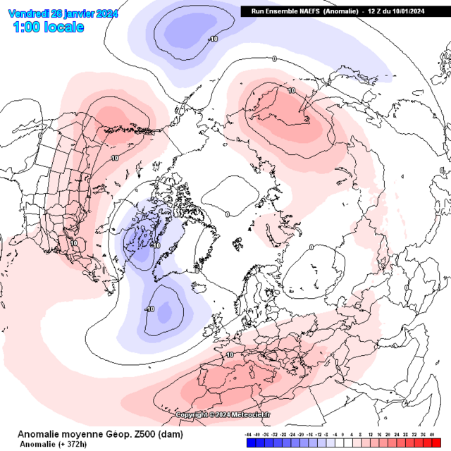
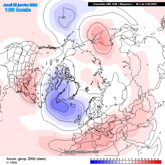
Detailed post discussing the Greenland High plus the patterns heading through Jan week 4


 8 minutes ago, Kirkcaldy Weather said:
Mid January 2024
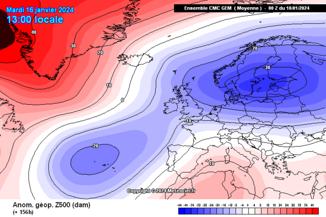
This period of weather has developed as a result of the suite of teleconnective feedback working in tandem as discussed in depth across many of my posts since latter December and within my winter outlook.
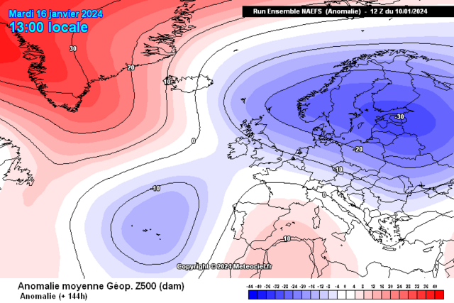
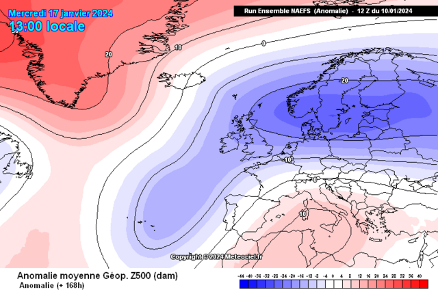
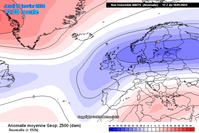
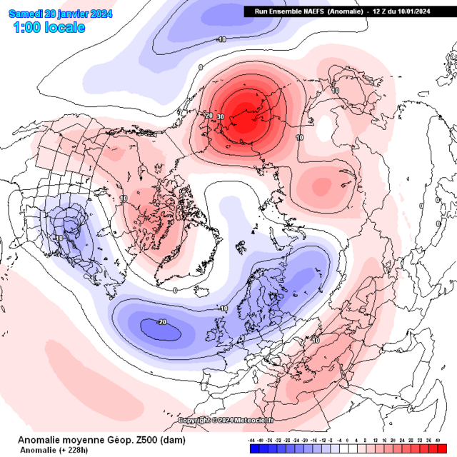
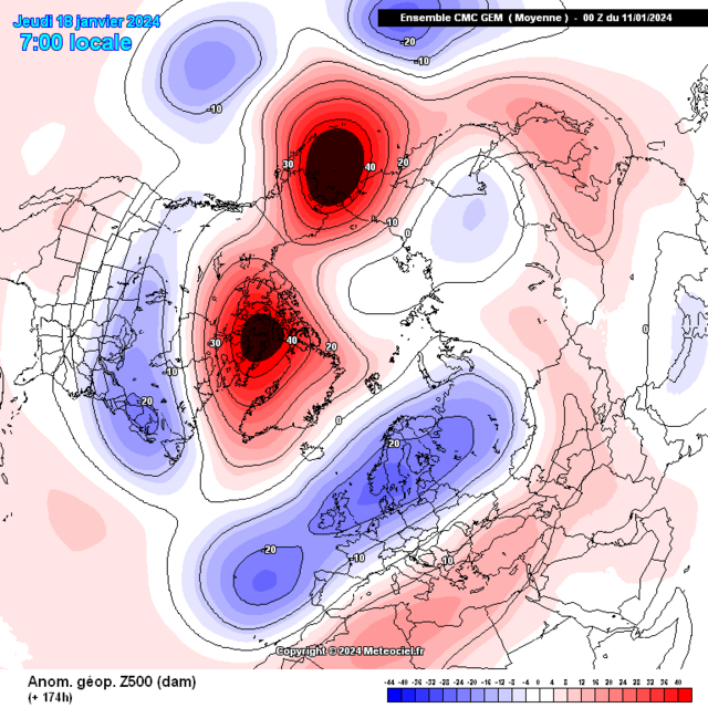
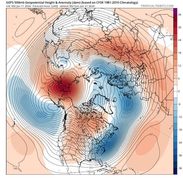
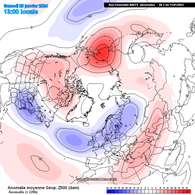
The peak strength to this Greenland High is occuring between now [January 15th] and lasting for roughly the next 5>6 days, some parts of Greenland will likely be seeing record hpa values for this timeframe which are often depicted by the Black and purple anomalies over various model suites. Also some noteable High temperature anomalies in parts of Greenland.
As covered in various posts this event is bringing significant & severe winter weather including the UK and Ireland with multiple Ice days, snow events of varying varieties and intensity > snow streamers over North Northeast and Northwestern Scotland, also a small feature on a Northwest >> Southeast orientation which is set to bring further snowfall to the above areas whilst extending to include a large majority of Scotland including Central, some getting further East in Scotland and latest data is suggestive of a possible significant snow event particularly toward Northwestern England, potentially extending into the pennines, Northern Ireland may also receive snowfall.
Whilst a lower likliehood scenario there remains a chance of precipitation running across the far Southern > Southeastern Coast of England, this could fall as a wintry mix including snow.
As mentioned in my quoted post as an Atlantic cyclone begins the merging process linking to the Scandinavian Baltic Trough which is also an elongating sector of the Tropospheric Vortex this will see the beginning of the expected significant/ severe flash flooding event(s) particularly focusing over Portugal and into Northwest Spain. Ahead of this also within the same connecting troughing we'll see a transitioning rain event which will develop into a significant snowfall through France into the Netherlands and other low countries such as Belgium this event will gradually shift its focus and impacts further South and Southeast through parts of Germany and once more a significant event into the Alps. Eventually this wintry weather moves eastward into other areas of Europe.
As the Greenland High begins intensification the EXTREME and historical level cold [see my posts in the Global model thread and the record threads] which had began development from Western Canada / Northwest America begins transitioning / expansion gradually Southeast & Eastward
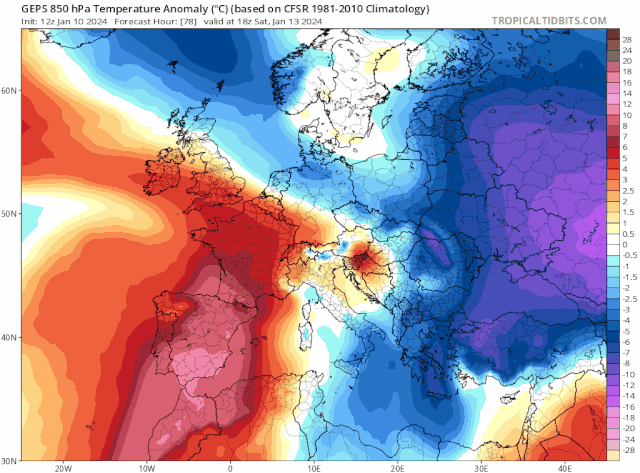
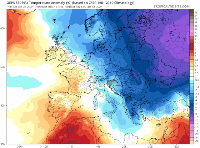
850hpa temperature anomalies
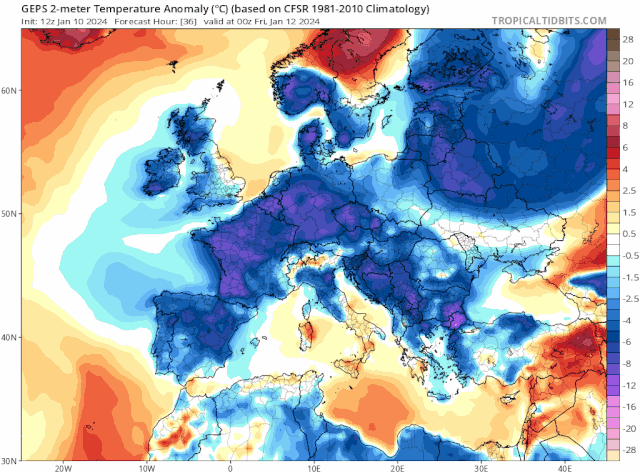
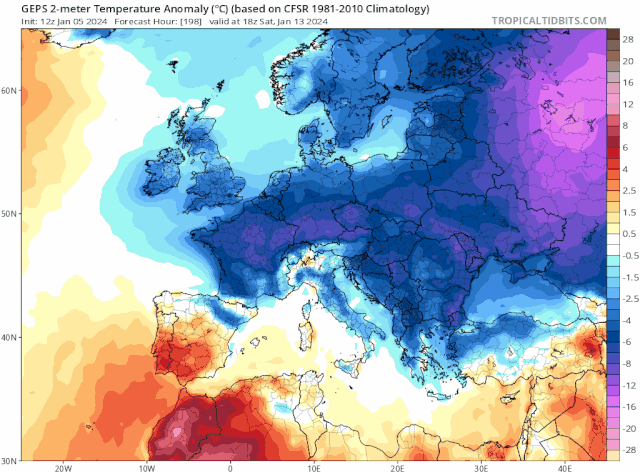
Surface Temperature anomalies
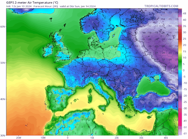
Actual surface temperature
This is depicted excellently if we look at the Arctic and North Atlantic Oscillation values.
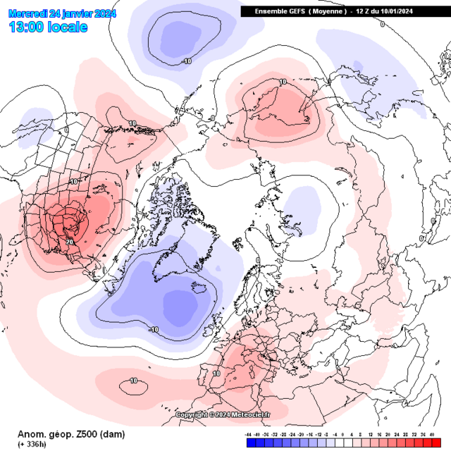
3 minutes ago, Kirkcaldy Weather said:Following onto the post above I've done an in depth post of the impacts connecting with the Greenland High.
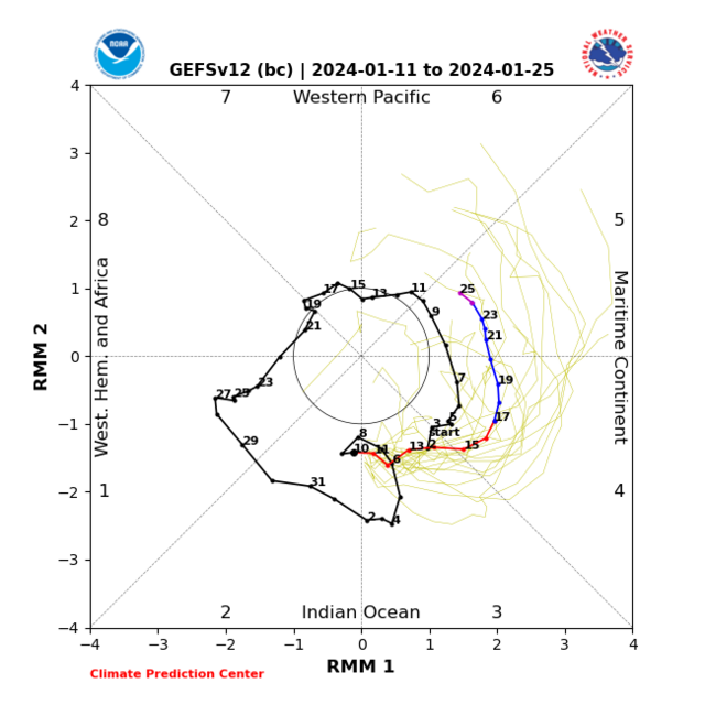
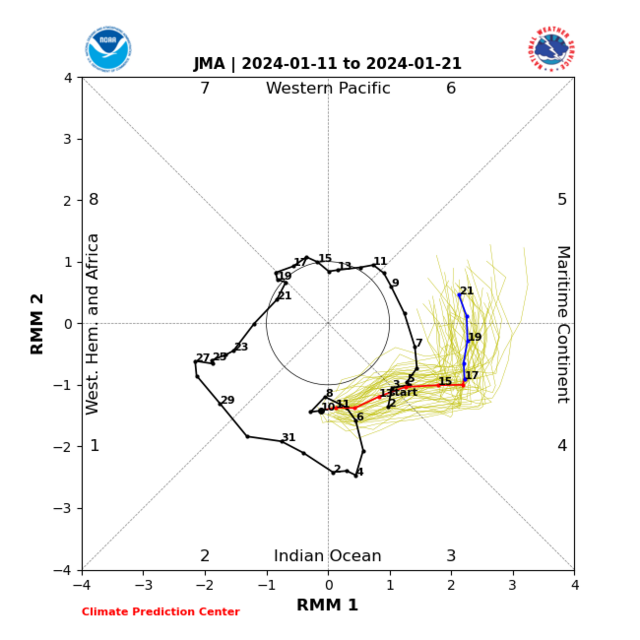
'Again links with recent MJO phases this links with the PNA heading more into positive territory, door opens for a snowy system into Northeast America from roughly Jan 18th - 21st IMO
 '
'
Excellent to see
'Following the MJO passing across the Maritimes we begin seeing feedback of phases 1 and into 2 as January week 4 gets started a high forms toward the Maritimes which might extend through Canada, also I'm starting to notice the trend toward cut off low development toward Mexico, far Southwest US
"
This will have a setup which favours a + North Atlantic Oscillation especially during January week 4, this favours above average temperatures. Initially there is also more of a -PNA which also connects with the above average temperatures across the eastern portion of America / Canada and Maritimes with below average further west.
-
6
-
 4
4
-
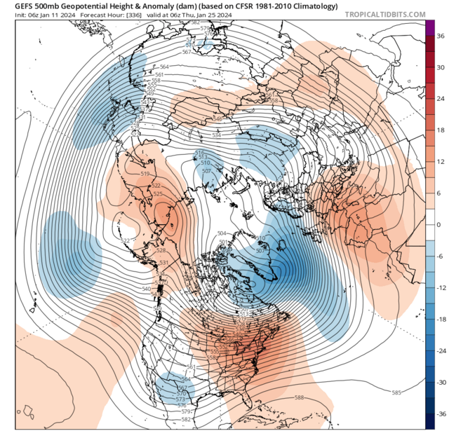
On 11/01/2024 at 14:31, Kirkcaldy Weather said:
Super happy with the evolution since Late December now its becoming clearer in some finer detailing of this upcoming significant cold episode.
- Significant cold front moving south bringing significant below avg surface and 850hpa temperature anomalies by Sunday January 14th
- Surface temperatures point to a severe winter weather event.
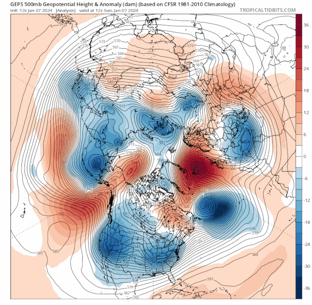
"Through Jan week 2 toward the aforementioned middle month period we'll have the -NAO,-AO,PNA,El Ninò,MJO and Easterly QBO feeding towards the setup going retrogressive this will have a couple of significant changes with a westwards moving trough which links with expectations into elongation with the centre over the Baltics, Scandinavia as this is occuring the high pressure and block will shift northwestward to reside across Greenland this is more supporting of colder 850hpa temps likely from the Northeast, we maintain below average surface temps during this with possible scope for these to get colder"
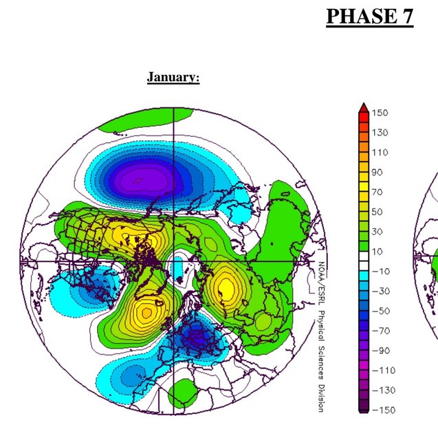
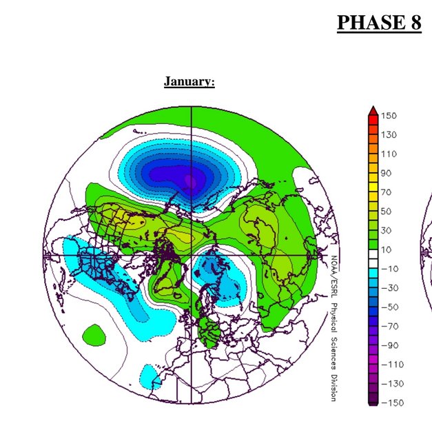
'Seeing the heart of these colder temperatures at surface and upper level becoming centred through Europe with just the far south of the UK clinging to is perfectly anticipated thanks to the phase 7 feedback'
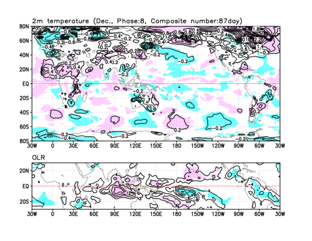
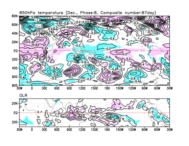
Note the movement northwards of this cold anomaly from phases 7 into 8
From the above we can Note the significance of both 850hpa temps and in particular surface temperatures as both will contain anomalies roughly 15 > 20 Degrees BELOW AVERAGE, this will give multiple ice days in succession with liklihood of significant ice days over Scotland and Northern regions of England though there will be ice days for Ireland

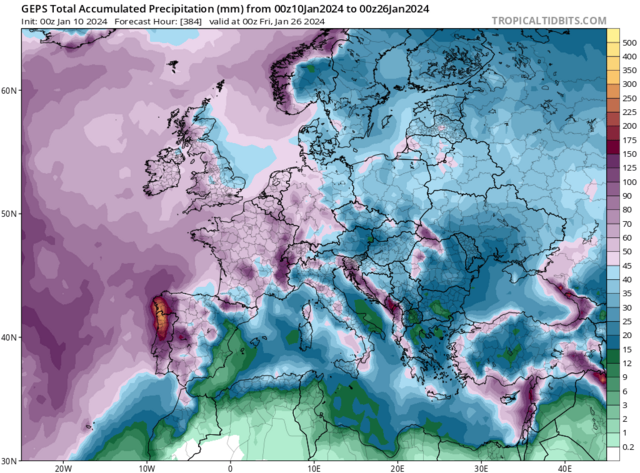
A timeframe with a focal point towards wintry precip event(s) will be from January 16th through 18th with the cyclone in the Atlantic starting the merging process to the Scandinavian Baltic Trough
7 day precip anomaly. I'm expectant of significant flash flood event[s] for Portugal and its border into Northwest Spain
Such an excellent showcase of all the teleconnective feedback coming into one stunning meteorological display


"My thinking holds steady with the MJO working into the Maritimes generally Mid Jan maybe into January week 3 as this increases cyclonic developments seeing these sorts of 500hpa setups during that period is very plausible.''
Following the MJO passing across the Maritimes we begin seeing feedback of phases 1 and into 2 as January week 4 gets started a high forms toward the Maritimes which might extend through Canada, also I'm starting to notice the trend toward cut off low development toward Mexico, far Southwest US
Following onto the post above I've done an in depth post of the impacts connecting with the Greenland High.
3 minutes ago, Kirkcaldy Weather said:Mid January 2024
This period of weather has developed as a result of the suite of teleconnective feedback working in tandem as discussed in depth across many of my posts since latter December and within my winter outlook.
The peak strength to this Greenland High is occuring between now [January 15th] and lasting for roughly the next 5>6 days, some parts of Greenland will likely be seeing record hpa values for this timeframe which are often depicted by the Black and purple anomalies over various model suites. Also some noteable High temperature anomalies in parts of Greenland.
As covered in various posts this event is bringing significant & severe winter weather including the UK and Ireland with multiple Ice days, snow events of varying varieties and intensity > snow streamers over North Northeast and Northwestern Scotland, also a small feature on a Northwest >> Southeast orientation which is set to bring further snowfall to the above areas whilst extending to include a large majority of Scotland including Central, some getting further East in Scotland and latest data is suggestive of a possible significant snow event particularly toward Northwestern England, potentially extending into the pennines, Northern Ireland may also receive snowfall.
Whilst a lower likliehood scenario there remains a chance of precipitation running across the far Southern > Southeastern Coast of England, this could fall as a wintry mix including snow.
As mentioned in my quoted post as an Atlantic cyclone begins the merging process linking to the Scandinavian Baltic Trough which is also an elongating sector of the Tropospheric Vortex this will see the beginning of the expected significant/ severe flash flooding event(s) particularly focusing over Portugal and into Northwest Spain. Ahead of this also within the same connecting troughing we'll see a transitioning rain event which will develop into a significant snowfall through France into the Netherlands and other low countries such as Belgium this event will gradually shift its focus and impacts further South and Southeast through parts of Germany and once more a significant event into the Alps. Eventually this wintry weather moves eastward into other areas of Europe.
As the Greenland High begins intensification the EXTREME and historical level cold [see my posts in the Global model thread and the record threads] which had began development from Western Canada / Northwest America begins transitioning / expansion gradually Southeast & Eastward
850hpa temperature anomalies
Surface Temperature anomalies
Actual surface temperature
This is depicted excellently if we look at the Arctic and North Atlantic Oscillation values.
'Again links with recent MJO phases this links with the PNA heading more into positive territory, door opens for a snowy system into Northeast America from roughly Jan 18th - 21st IMO
'
Excellent to see
'Following the MJO passing across the Maritimes we begin seeing feedback of phases 1 and into 2 as January week 4 gets started a high forms toward the Maritimes which might extend through Canada, also I'm starting to notice the trend toward cut off low development toward Mexico, far Southwest US
"
This will have a setup which favours a + North Atlantic Oscillation especially during January week 4, this favours above average temperatures. Initially there is also more of a -PNA which also connects with the above average temperatures across the eastern portion of America / Canada and Maritimes with below average further west.
-
5
-
2
-
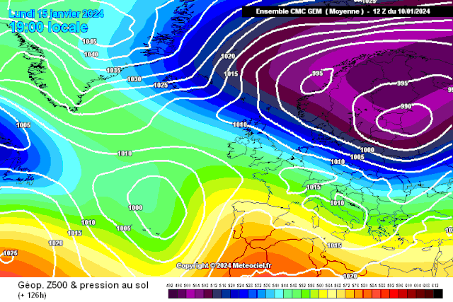
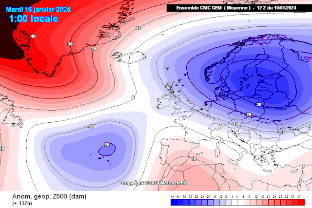
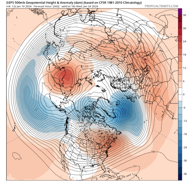
Mid January 2024
This period of weather has developed as a result of the suite of teleconnective feedback working in tandem as discussed in depth across many of my posts since latter December and within my winter outlook.
On 11/01/2024 at 14:31, Kirkcaldy Weather said:Super happy with the evolution since Late December now its becoming clearer in some finer detailing of this upcoming significant cold episode.
- Significant cold front moving south bringing significant below avg surface and 850hpa temperature anomalies by Sunday January 14th
- Surface temperatures point to a severe winter weather event.
"Through Jan week 2 toward the aforementioned middle month period we'll have the -NAO,-AO,PNA,El Ninò,MJO and Easterly QBO feeding towards the setup going retrogressive this will have a couple of significant changes with a westwards moving trough which links with expectations into elongation with the centre over the Baltics, Scandinavia as this is occuring the high pressure and block will shift northwestward to reside across Greenland this is more supporting of colder 850hpa temps likely from the Northeast, we maintain below average surface temps during this with possible scope for these to get colder"
'Seeing the heart of these colder temperatures at surface and upper level becoming centred through Europe with just the far south of the UK clinging to is perfectly anticipated thanks to the phase 7 feedback'
Note the movement northwards of this cold anomaly from phases 7 into 8
From the above we can Note the significance of both 850hpa temps and in particular surface temperatures as both will contain anomalies roughly 15 > 20 Degrees BELOW AVERAGE, this will give multiple ice days in succession with liklihood of significant ice days over Scotland and Northern regions of England though there will be ice days for Ireland
A timeframe with a focal point towards wintry precip event(s) will be from January 16th through 18th with the cyclone in the Atlantic starting the merging process to the Scandinavian Baltic Trough
7 day precip anomaly. I'm expectant of significant flash flood event[s] for Portugal and its border into Northwest Spain
Such an excellent showcase of all the teleconnective feedback coming into one stunning meteorological display
"My thinking holds steady with the MJO working into the Maritimes generally Mid Jan maybe into January week 3 as this increases cyclonic developments seeing these sorts of 500hpa setups during that period is very plausible.''
Following the MJO passing across the Maritimes we begin seeing feedback of phases 1 and into 2 as January week 4 gets started a high forms toward the Maritimes which might extend through Canada, also I'm starting to notice the trend toward cut off low development toward Mexico, far Southwest US
The peak strength to this Greenland High is occuring between now [January 15th] and lasting for roughly the next 5>6 days, some parts of Greenland will likely be seeing record hpa values for this timeframe which are often depicted by the Black and purple anomalies over various model suites. Also some noteable High temperature anomalies in parts of Greenland.
As covered in various posts this event is bringing significant & severe winter weather including the UK and Ireland with multiple Ice days, snow events of varying varieties and intensity > snow streamers over North Northeast and Northwestern Scotland, also a small feature on a Northwest >> Southeast orientation which is set to bring further snowfall to the above areas whilst extending to include a large majority of Scotland including Central, some getting further East in Scotland and latest data is suggestive of a possible significant snow event particularly toward Northwestern England, potentially extending into the pennines, Northern Ireland may also receive snowfall.
Whilst a lower likliehood scenario there remains a chance of precipitation running across the far Southern > Southeastern Coast of England, this could fall as a wintry mix including snow.
As mentioned in my quoted post as an Atlantic cyclone begins the merging process linking to the Scandinavian Baltic Trough which is also an elongating sector of the Tropospheric Vortex this will see the beginning of the expected significant/ severe flash flooding event(s) particularly focusing over Portugal and into Northwest Spain. Ahead of this also within the same connecting troughing we'll see a transitioning rain event which will develop into a significant snowfall through France into the Netherlands and other low countries such as Belgium this event will gradually shift its focus and impacts further South and Southeast through parts of Germany and once more a significant event into the Alps. Eventually this wintry weather moves eastward into other areas of Europe.
As the Greenland High begins intensification the EXTREME and historical level cold [see my posts in the Global model thread and the record threads] which had began development from Western Canada / Northwest America begins transitioning / expansion gradually Southeast & Eastward
850hpa temperature anomalies
Surface Temperature anomalies
Actual surface temperature
This is depicted excellently if we look at the Arctic and North Atlantic Oscillation values.
-
-
-
-
- Popular Post
If Santa is still dropping presents aff I'll take this from the Icon

-
17
-
 1
1
-
1
-
-
-
-
Brill stream at Stonehaven as a streamer is ongoing

-
8
-
-
-
-
-
- Popular Post
Upon seeing statements that would lead anyone to believe a drastic change had occured with our upcoming setup IT HAS NOT.
Entirely fitting to my thoughts from 8 days ago
On 05/01/2024 at 20:01, Kirkcaldy Weather said:Looking to the end of January week 2 into Mid month through roughly 5--6 days to have the most significant cold upper and lower temperatures
Jan 15th - 21st was always probable for the most severe conditions
-
10
-
2
-
There has been good consistency from the majority of modelling with my thoughts from 8 days ago January 5th remaining steadfast, this IS a significant- Severe winter weather event
- 850 hpa temperatures briefly 15-20 degrees below average across nearly all of the UK
- SIGNIFICANT- SEVERE ice days x multiple in succession
- Surface temperatures also 15-20 Degrees below avg again covering large quantities of the UK and Ireland
"At the moment we're looking at the latter stage of Jan week 2 MIDMONTH through about 5>6 days for the coldest surface and 850hpa temps"
This was always probable from January 15th to around the 21st
-
7
-
- Popular Post
Ideas for Tuesday / Weds

-
9
-
1
-
1
-
-
-
-
- Popular Post
Re the flow, this will be a general mix of Northerly and North Northwesterly which gives a fairly reasonable idea for these zones to be seeing the highest precip totals which will be of the snowy conditions. This WILL be a significant / SEVERE winter weather event
The above gives a good look into the flow plus something I'd not taken time to note is the fact the Scandinavian Baltic trough is also part of an elongating sector of the Tropospheric Vortex this will extend into our setup.
Although there will be snowfall again focusing with the N NNW feed areas outwith this don't look to receive very much precip overall with this being seen in the precip anomalies it's below / drier than average / average in association with our upcoming pattern with Above average precip signal further ahead once the setup attempts to become less cold as we approach Jan week 4.
The snowfall opportunity is there into Tuesday which ATM looks like being most impactful toward the northwest but could extend southeastwards
Frequent Ice Days, Multiple days with surface temperatures 15-20 degrees below avg and 850hpa temperatures briefly also seeing these anomalies this is the real deal regardless of the snow amounts... each event has its own subtle characteristics but a vibe of December 2022 definitely and its an underrated event again as it was generally drier but still very noteworthy.
-
5
-
4
-
7
-


Autumn AND Winter 2023/24 Northern Hemisphere Low Temperature & snowfall Reports & Records (twitter content)
in Spring Weather Discussion
Posted