


Kirkcaldy Weather
-
Posts
6,694 -
Joined
-
Last visited
-
Days Won
11
Content Type
Forums
Blogs
Gallery
Events
Learn About Weather and Meteorology
Community guides
Posts posted by Kirkcaldy Weather
-
-
The initial process of cut off low development has delivered impressive rainfall records in California and Arizona

And significant snow in higher terrain / Sierras
As this initial cut off low gradually moves further east there's a number of impactful conditions on the way over the next week and heading into the start of February.
Over the next couple of days we'll have a significant flash flood threat focusing in across the Gulf and more southern States.
As the cut off low(s) [troughing] gradually progresses east and in connection with more of a classical +PNA setup we'll have a system which has potential of becoming a potentially disruptive snowstorm into Northeast America, I'm expectant of this during the 28th - 30th of January
During the last days of January I'm watching another cut off low development across the East Pacific which heads into Mexico, whether it takes on any tropical characteristics we'll see.
The energy of that cut off low development will link to further Pacific trough developments in connection with recent MJO phase influences and the MJO being active within the Pacific during this timeframe.
From the last days of Jan through week 1 of Feb this will have a significantly wet anomaly for California up the US west coast into the Pacific Northwest and moving into the Southwest States and Mexico. Some of the precip will fall as snow in higher terrains such as the Sierras.
-
- Popular Post
On 21/01/2024 at 07:34, thebigyin said:Great Post by @Kirkcaldy Weather as usual in the mod thread provides a nice summary of situation as well as look ahead...stormy, and future winter potential. On the latter, to me the models for early Feb now look like a cold spell could start to appear and a number ensembles across models have notable support. But maybe not...
it doesn't look like much change today sadly to me. Force 11 or 12 in places. Expect some upgrades to warnings today. Large parts of central england only under yellow which seems odd, and areas such as forth Clyde maybe red? Hopefully no stingjet to the tail as it leaves, which in my experience for here can lead to nastiness here. Stay safe everyone

Cheers for those nice words @thebigyin much appreciated


Big Congrats to @Northern Strath will the baby have middle names including Isha / Jacelyn
 19 hours ago, Polar Gael said:
This is concerning. Current disruptive stuff is looking sustained for days. Definitely preferred the cauld spell - any sign yet of a return to cauld in Feburary @Kirkcaldy Weather?
Not much to add onto my post in the mod thread really.
My stats from Jan 6th
January 6th
Max Temperature 7.6C
Max Dewpoint 6.9C
Min Temperature 0.1C
Min Dewpoint 0.0C
January 7th
Max Temperature 5.7C
Max Dewpoint 5.6C
Min Temperature -0.7C
Min Dewpoint -1.1C
January 8th
Max Temperature 4.9C
Max Dewpoint 4.6C
Min Temperature -0.9C
Min Dewpoint -1.3C
January 9th
Max Temperature 4.7C
Max Dewpoint 2.2C
Min Temperature 2.4C
Min Dewpoint -0.8C
January 10th
Max Temperature 5.4C
Max Dewpoint 4.6C
Min Temperature 2.5C
Min Dewpoint 1.0C
January 11th
Max Temperature 6.3C
Max Dewpoint 4.5C
Min Temperature 2.9C
Min Dewpoint 1.5C
January 12th
Max Temperature 4.1C
Max Dewpoint 3.7C
Min Temperature 0.2C
Min Dewpoint -0.5C
January 13th
Max Temperature 10.1C
Max Dewpoint 6.7C
Min Temperature 3.1C
Min Dewpoint 1.3C
January 14th
Max Temperature 5.6C
Max Dewpoint 1.8C
Min Temperature -0.7C
Min Dewpoint -3.9C
January 15th Start Of Significant Cold Anomalies
Max Temperature 3.4C
Max Dewpoint -2.2C
Min Temperature -2.6C
Min Dewpoint -5.5C
Averages
Temperature -0.1C
Dewpoint -4.6C
January 16th
Max Temperature 3.3C
Max Dewpoint 1.7C
Min Temperature -2.9C
Min Dewpoint -4.2C
Averages
Temperature 0.0C
Dewpoint -1.7C
January 17th
Max Temperature 3.1C
Max Dewpoint -1.9C
Min Temperature -4.1C
Min Dewpoint -6.1C
Averages
Temperature -1.7C
Dewpoint -4.4C
January 18th
Max Temperature 4.4C
Max Dewpoint -2.1C
Min Temperature -4.1C
Min Dewpoint -6.4C
Averages
Temperature -0.6C
Dewpoint -3.7C
January 19th
Max Temperature 5.7C
Max Dewpoint 2.9C
Min Temperature -1.2C
Min Dewpoint -2.9C
Noteworthy Pressure readings
January 9th
Max 1040.20hpa
Min 1038.30hpa
January 11th
Max 1042.91hpa wow
Min 1038.81hpa
January 12th
Max 1041.59hpa
Min 1025.60hpa
Pressure fall of 15.99hpa in 24hours
I've put together an in depth look at how severe and extreme the past few weeks have been in Canada, America and Europe

 5 minutes ago, Kirkcaldy Weather said:
Wanted to do a longer post and look into just how severe and extreme the past few weeks have been.
A lot of the years that the past few weeks of cold anomalies are comparable with are among the top analogues from my winter outlook
Starting with the UK and European countries such as France. The peak of cold conditions appear to have been during January 18th > 19th, I took the following screenshot during early hours of the 19th as a bit of a reference, credit coolwx
How coolwx works is by displaying the following values
Many of the values were around 50 or so years in Magnitude though there could very well have been some which surpassed this.
CANADA AND USA
There are numerous states in which the January 2024 records are comparable with some of the coldest winter weather events in recorded history like 1947 and 1962/1963 and other extreme events such as February 2021 and February/ March 2018 and December 2022.
One of the most noteable records here as it breaks the prior record by quite a large amount 2.9C and thats a weekly period too
These too


-
 7
7
-
 1
1
-
 3
3
-
2 minutes ago, Kirkcaldy Weather said:
Wanted to do a longer post and look into just how severe and extreme the past few weeks have been.
A lot of the years that the past few weeks of cold anomalies are comparable with are among the top analogues from my winter outlook
Starting with the UK and European countries such as France. The peak of cold conditions appear to have been during January 18th > 19th, I took the following screenshot during early hours of the 19th as a bit of a reference, credit coolwx
How coolwx works is by displaying the following values
Many of the values were around 50 or so years in Magnitude though there could very well have been some which surpassed this.
CANADA AND USA
There are numerous states in which the January 2024 records are comparable with some of the coldest winter weather events in recorded history like 1947 and 1962/1963 and other extreme events such as February 2021 and February/ March 2018 and December 2022.
One of the most noteable records here as it breaks the prior record by quite a large amount 2.9C and thats a weekly period too
These too
-
1
-
-
On 11/10/2023 at 22:16, Kirkcaldy Weather said:
Section 2 Kirkcaldy Weathers Official 2023 >>> 2024 Winter Outlook
Most synchronistic winter years connected with 2023 --- 2024
YEARS I BELIEVE ARE GREAT COMPARISONS FOR THIS YEAR
BOLD ARE THE GREATEST SIMILAR FEATURES
NUMBER 1 2009-2010. 2008/2009. 1976-1977, 2012-2013, 2010-2011. 1981-1982, 1962-63, 1967-1968, 1946--47
1 minute ago, Kirkcaldy Weather said:Wanted to do a longer post and look into just how severe and extreme the past few weeks have been.
A lot of the years that the past few weeks of cold anomalies are comparable with are among the top analogues from my winter outlook
Starting with the UK and European countries such as France. The peak of cold conditions appear to have been during January 18th > 19th, I took the following screenshot during early hours of the 19th as a bit of a reference, credit coolwx
How coolwx works is by displaying the following values
Many of the values were around 50 or so years in Magnitude though there could very well have been some which surpassed this.
CANADA AND USA
There are numerous states in which the January 2024 records are comparable with some of the coldest winter weather events in recorded history like 1947 and 1962/1963 and other extreme events such as February 2021 and February/ March 2018 and December 2022.
One of the most noteable records here as it breaks the prior record by quite a large amount 2.9C and thats a weekly period too
These too
-
Just now, Kirkcaldy Weather said:
Wanted to do a longer post and look into just how severe and extreme the past few weeks have been.
A lot of the years that the past few weeks of cold anomalies are comparable with are among the top analogues from my winter outlook
Starting with the UK and European countries such as France. The peak of cold conditions appear to have been during January 18th > 19th, I took the following screenshot during early hours of the 19th as a bit of a reference, credit coolwx
How coolwx works is by displaying the following values
Many of the values were around 50 or so years in Magnitude though there could very well have been some which surpassed this.
CANADA AND USA
There are numerous states in which the January 2024 records are comparable with some of the coldest winter weather events in recorded history like 1947 and 1962/1963 and other extreme events such as February 2021 and February/ March 2018 and December 2022.
One of the most noteable records here as it breaks the prior record by quite a large amount 2.9C and thats a weekly period too
These too
-
Wanted to do a longer post and look into just how severe and extreme the past few weeks have been.
A lot of the years that the past few weeks of cold anomalies are comparable with are among the top analogues from my winter outlook
On 11/10/2023 at 22:16, Kirkcaldy Weather said:Section 2 Kirkcaldy Weathers Official 2023 >>> 2024 Winter Outlook
Most synchronistic winter years connected with 2023 --- 2024
YEARS I BELIEVE ARE GREAT COMPARISONS FOR THIS YEAR
BOLD ARE THE GREATEST SIMILAR FEATURES
NUMBER 1 2009-2010. 2008/2009. 1976-1977, 2012-2013, 2010-2011. 1981-1982, 1962-63, 1967-1968, 1946--47
Starting with the UK and European countries such as France. The peak of cold conditions appear to have been during January 18th > 19th, I took the following screenshot during early hours of the 19th as a bit of a reference, credit coolwx
How coolwx works is by displaying the following values
Many of the values were around 50 or so years in Magnitude though there could very well have been some which surpassed this.
CANADA AND USA
There are numerous states in which the January 2024 records are comparable with some of the coldest winter weather events in recorded history like 1947 and 1962/1963 and other extreme events such as February 2021 and February/ March 2018 and December 2022.
One of the most noteable records here as it breaks the prior record by quite a large amount 2.9C and thats a weekly period too
These too
-
1
-
-
- Popular Post
A major issue I foresee is the amount of time we're going to have at least 50mph gusts across most of Scotland there wont be much if any break ahead of our next storm during the 23rd and 24th add in the fact we'll also see multiple spells of these gusts being funnelled directly west > east usually a more impactful direction.
-
11
-
4
-
Lots to cover.


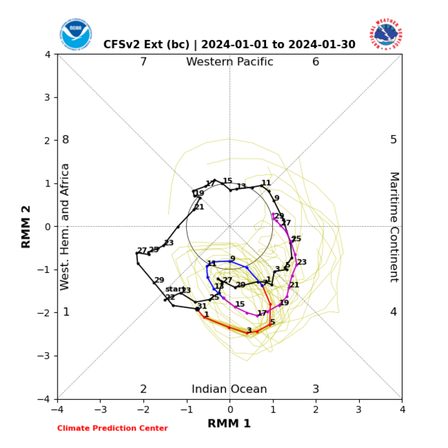
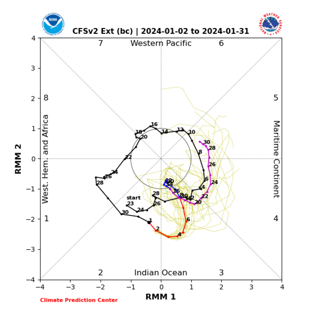
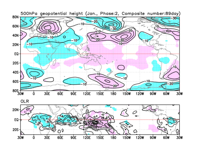
"Now lets dive into the MJO because it carries importance at various levels.
This could have some impact with regard to an important evolution of the cyclonic developments across Canada into the Maritimes I'd still favour mid Jan but might be slightly later should we get the interference a la the CFS."
Hats off to the CFS yet again as it was pretty much the only model keen and picking up on the Indian Ocean Dipole causing some interference which I discussed in my post from Jan 2nd

As the MJO begins crossing through the Maritimes generally from Mid Jan as discussed this works to aid cyclogenisis with 2 main times of interest.
Storm Isha
Come Sunday evening [January 21st] we'll have damaging gusts particularly through the Irish Sea with effects being most impactful toward Wales up across Southwest Scotland and moving Northeastwards
Heading toward Monday these highest gust speeds look to shift focus further southeast
Further potential damaging gusts cannot be ignored as a possibility across Scotland on the back of Isha
Using the 200mb Velocity data we can watch these focal points as the MJO influence works in tandem to aid this initial cyclonic development with Isha
To understand the next focal point lets go back to my comments from January 7th
"Again links with recent MJO phases this links with the PNA heading more into positive territory, door opens for a snowy system into Northeast America from roughly Jan 18th - 21st IMO

 '
'
This same system becomes our next area of potential disruption by January 23rd
You can also watch some of the next patterns setting up on the gif above linking to my comments from my post on January 11th

'Following the MJO passing across the Maritimes we begin seeing feedback of phases 1 and into 2 as January week 4 gets started a high forms toward the Maritimes which might extend through Canada, also I'm starting to notice the trend toward cut off low development toward Mexico, far Southwest US
'
With the above we can see some of the important 500hpa setups developing into our current timeframe and into week 4 of January (and beyond)
Low pressures from Greenland and into the Arctic
High pressure forming across the Maritimes. A secondary high toward the Northwest of the US and Canada which links with PNA behaviour more on that shortly.
Formation of cut off low(s) in that southwestern America > Mexico regions which also will lead into PNA behaviour.
High pressures East of the UK.
'This will have a setup which favours a + North Atlantic Oscillation especially during January week 4, this favours above average temperatures. Initially there is also more of a -PNA which also connects with the above average temperatures across the eastern portion of America / Canada and Maritimes with below average further west.'
Following on from this as the preceeding MJO phases input begins to feed into the setups from week 4 of Jan onward the above remains true with further developments.
Looks like this initial cut off low will develop into a +PNA during the very end of Jan
As discussed above there continues to be the trend of the high extending across Canada
As we head into February and again as the preceeding MJO input begins to materialise this will see the high extension into the Atlantic with further developments of high pressure again toward the Maritimes.
This sees low pressure[s] becoming centred toward the north of the UK
As discussed in my post from Tuesday we're seeing patterns favouring above average temperature scenarios across large swathes ie Europe and America particularly Northeast US and Maritimes > Eastern Canada.
Colder temperatures become focused into Asia in association with these patterns.
I'm also looking toward the very last days of Jan and into February for stratospheric warming(s) as this is supported again with MJO feedback.
Original post: https://community.netweather.tv/topic/99793-model-output-discussion-cold-spell-ending-what-next/?do=findComment&comment=5019918-
2
-
-
- Popular Post
Lots to cover.
"Now lets dive into the MJO because it carries importance at various levels.
This could have some impact with regard to an important evolution of the cyclonic developments across Canada into the Maritimes I'd still favour mid Jan but might be slightly later should we get the interference a la the CFS."
Hats off to the CFS yet again as it was pretty much the only model keen and picking up on the Indian Ocean Dipole causing some interference which I discussed in my post from Jan 2nd
As the MJO begins crossing through the Maritimes generally from Mid Jan as discussed this works to aid cyclogenisis with 2 main times of interest.
Storm Isha
Come Sunday evening [January 21st] we'll have damaging gusts particularly through the Irish Sea with effects being most impactful toward Wales up across Southwest Scotland and moving Northeastwards
Heading toward Monday these highest gust speeds look to shift focus further southeast
Further potential damaging gusts cannot be ignored as a possibility across Scotland on the back of Isha
Using the 200mb Velocity data we can watch these focal points as the MJO influence works in tandem to aid this initial cyclonic development with Isha
To understand the next focal point lets go back to my comments from January 7th
"Again links with recent MJO phases this links with the PNA heading more into positive territory, door opens for a snowy system into Northeast America from roughly Jan 18th - 21st IMO
'
This same system becomes our next area of potential disruption by January 23rd
You can also watch some of the next patterns setting up on the gif above linking to my comments from my post on January 11th
'Following the MJO passing across the Maritimes we begin seeing feedback of phases 1 and into 2 as January week 4 gets started a high forms toward the Maritimes which might extend through Canada, also I'm starting to notice the trend toward cut off low development toward Mexico, far Southwest US
'
With the above we can see some of the important 500hpa setups developing into our current timeframe and into week 4 of January (and beyond)
Low pressures from Greenland and into the Arctic
High pressure forming across the Maritimes. A secondary high toward the Northwest of the US and Canada which links with PNA behaviour more on that shortly.
Formation of cut off low(s) in that southwestern America > Mexico regions which also will lead into PNA behaviour.
High pressures East of the UK.
'This will have a setup which favours a + North Atlantic Oscillation especially during January week 4, this favours above average temperatures. Initially there is also more of a -PNA which also connects with the above average temperatures across the eastern portion of America / Canada and Maritimes with below average further west.'
Following on from this as the preceeding MJO phases input begins to feed into the setups from week 4 of Jan onward the above remains true with further developments.
Looks like this initial cut off low will develop into a +PNA during the very end of Jan
As discussed above there continues to be the trend of the high extending across Canada
As we head into February and again as the preceeding MJO input begins to materialise this will see the high extension into the Atlantic with further developments of high pressure again toward the Maritimes.
This sees low pressure[s] becoming centred toward the north of the UK
As discussed in my post from Tuesday we're seeing patterns favouring above average temperature scenarios across large swathes ie Europe and America particularly Northeast US and Maritimes > Eastern Canada.
Colder temperatures become focused into Asia in association with these patterns.
I'm also looking toward the very last days of Jan and into February for stratospheric warming(s) as this is supported again with MJO feedback.
-
21
-
23
-
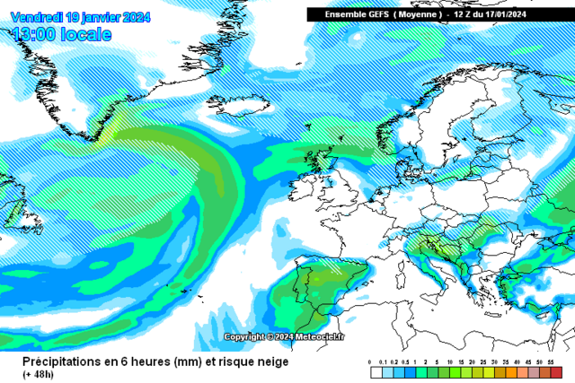
January 17th and 18th 2024


 On 17/01/2024 at 19:31, Kirkcaldy Weather said:
Majority of the finer resolution models aren't really seeing much however the ever trusty wrf 2km
does get the flow sufficiently enough into the Northeast by this evening through the first part of the night
Bit more oomph with these streamers with an increased level of instability available and something we'd not chatted about thus far is thundersnow, I noted some strikes on radar toward Ayr yesterday but the precip was rain, tonight along the Moray firth toward the far Northeast corner look best probably around The A96 northward into the coastal regions a la Lossiemouth Buckie etc
Using the Skew Ts and focused at the CAPE values really decent with amounts remaining considerable even into midnight hours
Very neat showcase of this generally during today and tonight
Use the snow accumulations charts as more of a guide as streamer development is always fine margins but I'd be expectant of the area up toward @Halfamilefromnowhere having in the region of a foot of snow... that's all new snow BTW
Similar look to the setup during Friday as yesterday's
The extent through central Scotland still shows some model discrepancies however the flow is better aligned generally at least for some period of time.
Regardless if it falls as rain snow or a wintry mix could bring travel disruption with it going onto already frozen surfaces.
BOOM
 Early contender for best satellite pic of the year
  On 17/01/2024 at 21:15, Kirkcaldy Weather said:
Lol an early winner
first lightning literally just a few miles east of my aforementioned area. Fab
On 17/01/2024 at 20:26, Kirkcaldy Weather said: A brief update areas to keep a close watch on tonight - tomorrow
As multiple areas of increased instability form we'll have increasing streamer development of which I'm particularly interested over toward the Humber and expect there will be increased possibilities for thundersnow certainly good CAPE just offshore but some of this pushes towards the coast bringing the streamers, looking likely for a shot to see at least a covering from the Humber down into the wash and toward East Anglia especially northern East Anglia.
Across to the west and the Irish Sea also sees an increase in CAPE creating a nice looking streamer heading into Wales especially Northwest and West Wales
The above being a general idea. Some modelling keeps the Humber event offshore however my thoughts above are just as much of a probability/possibility.
-
2
-
-
-
-
-
-
-
-
A golf course with that depth of snow is incredible,
great look at the snow shaft moving in
Webcam
FORTROSEGOLFCLUB.CO.UK-
7
-
-
- Popular Post
Lol an early winner
first lightning literally just a few miles east of my aforementioned area. Fab
-
10
-
1
-
- Popular Post
A brief update areas to keep a close watch on tonight - tomorrow
As multiple areas of increased instability form we'll have increasing streamer development of which I'm particularly interested over toward the Humber and expect there will be increased possibilities for thundersnow certainly good CAPE just offshore but some of this pushes towards the coast bringing the streamers, looking likely for a shot to see at least a covering from the Humber down into the wash and toward East Anglia especially northern East Anglia.
Across to the west and the Irish Sea also sees an increase in CAPE creating a nice looking streamer heading into Wales especially Northwest and West Wales
The above being a general idea. Some modelling keeps the Humber event offshore however my thoughts above are just as much of a probability/possibility.
-
9
-
1
-
- Popular Post
8 hours ago, Hawesy said:Met Office whispering in my ear: Becoming cloudier across northern and eastern parts overnight with a few snow showers for Angus and Fife.
Not buying it of course!
Majority of the finer resolution models aren't really seeing much however the ever trusty wrf 2km
does get the flow sufficiently enough into the Northeast by this evening through the first part of the night
Bit more oomph with these streamers with an increased level of instability available and something we'd not chatted about thus far is thundersnow, I noted some strikes on radar toward Ayr yesterday but the precip was rain, tonight along the Moray firth toward the far Northeast corner look best probably around The A96 northward into the coastal regions a la Lossiemouth Buckie etc
Using the Skew Ts and focused at the CAPE values really decent with amounts remaining considerable even into midnight hours
On 12/01/2024 at 14:07, Kirkcaldy Weather said:Re the flow, this will be a general mix of Northerly and North Northwesterly
Very neat showcase of this generally during today and tonight
Use the snow accumulations charts as more of a guide as streamer development is always fine margins but I'd be expectant of the area up toward @Halfamilefromnowhere having in the region of a foot of snow... that's all new snow BTW
Similar look to the setup during Friday as yesterday's
The extent through central Scotland still shows some model discrepancies however the flow is better aligned generally at least for some period of time.
Regardless if it falls as rain snow or a wintry mix could bring travel disruption with it going onto already frozen surfaces.
On 12/01/2024 at 14:07, Kirkcaldy Weather said:Scandinavian Baltic trough
BOOM
Early contender for best satellite pic of the year
-
10
-
4
-
-
-
-


Synchronicity with Historic Stats and Records, New Forecast Method 🤓🤠👨🏫
in Historic Weather
Posted