


Kirkcaldy Weather
-
Posts
6,693 -
Joined
-
Last visited
-
Days Won
11
Content Type
Forums
Blogs
Gallery
Events
Learn About Weather and Meteorology
Community guides
Posts posted by Kirkcaldy Weather
-
-
From my recent post in the Scottish thread
''With the influence of more of a -PNA paired to MJO phase 6 I'd not be shocked seeing potential for a storm as the associated troughing crosses the UK between February 8th > 12th"
Exciting scenarios appearing within this timeframe, dependant on orientation of the low(s) but definitely potential here for a snowstorm - blizzard within the UK / possibly Ireland.

Also increased threat of flash flooding into Portugal and extending across southern Europe in association with an increasingly strengthening Jet Stream in this region also within that timeframe.
With continuing phase 6 starting to transition into phase 7 and pairing to a re emerging and strengthening +PNA as we get toward and past Mid February there will be lots of tantalising charts


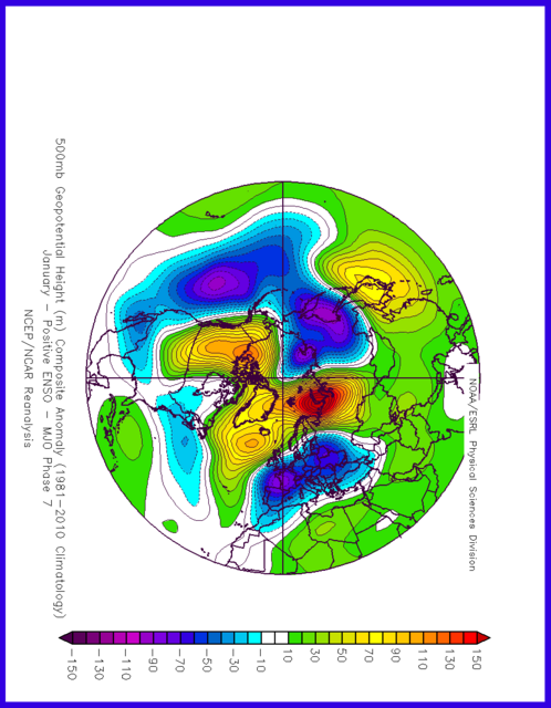
Absolutely Textbook El Ninò, simply stunning 500hpa evolutions


Original post: https://community.netweather.tv/topic/99814-model-output-discussion-22nd-jan-2024-onwards/?do=findComment&comment=5027650-
 2
2
-
-
- Popular Post
- Popular Post
From my recent post in the Scottish thread
''With the influence of more of a -PNA paired to MJO phase 6 I'd not be shocked seeing potential for a storm as the associated troughing crosses the UK between February 8th > 12th"
Exciting scenarios appearing within this timeframe, dependant on orientation of the low(s) but definitely potential here for a snowstorm - blizzard within the UK / possibly Ireland.
Also increased threat of flash flooding into Portugal and extending across southern Europe in association with an increasingly strengthening Jet Stream in this region also within that timeframe.
With continuing phase 6 starting to transition into phase 7 and pairing to a re emerging and strengthening +PNA as we get toward and past Mid February there will be lots of tantalising charts
Absolutely Textbook El Ninò, simply stunning 500hpa evolutions
-
10
-
 4
4
-
On 30/01/2024 at 20:28, Kirkcaldy Weather said:
With the influence of more of a -PNA paired to MJO phase 6 I'd not be shocked seeing potential for a storm as the associated troughing crosses the UK between February 8th > 12th


Exciting scenarios appearing within this timeframe, dependant on orientation of the low(s) but definitely potential here for a snowstorm - blizzard within the UK / possibly Ireland.
Also keeping a watch for increased risk of flash flooding impacts for Portugal which could extend across Southern Europe as an increasingly strong Jet Stream moves across the region also in this time period.
-
9
-
-
-
On 23/01/2024 at 18:12, Kirkcaldy Weather said:
As the cut off low(s) [troughing] gradually progresses east and in connection with more of a classical +PNA setup we'll have a system which has potential of becoming a potentially disruptive snowstorm into Northeast America, I'm expectant of this during the 28th - 30th of January
Excellent
Models did become confident on Newfoundland doing particularly well from this snowstorm
On 23/01/2024 at 18:12, Kirkcaldy Weather said:From the last days of Jan through week 1 of Feb this will have a significantly wet anomaly for California up the US west coast into the Pacific Northwest and moving into the Southwest States and Mexico. Some of the precip will fall as snow in higher terrains such as the Sierras.
We'll see 2 simultaneous cyclones bringing an increased liklihood of flash flooding, as the first which is currently coming into the west coast begins to traverse southeastwards it brings a significant flash flood threat into the Gulf States and we get our classic El Ninò setup / appearance.
With the Gulf cyclone I expect significant flash flood impacts between February 3rd and February 9th with this gradually moving east Northeast, might be a chance for a transition from rain to wintry precip - snow on the northwest flank as the cyclone approches the Carolina coast however this could also remain just offshore.
Some extreme amounts currently shown for Feb 4th somewhere in Louisianna such as Pilottown etc
-
2.3C and 100.8mm please
-
- Popular Post
Wind warnings out for tomorrow certainly strongest across the Western Isles pushing into the Northwest probably over toward the Great Glen with somewhat of a weakening as the front moves southeast across Scotland though still gusts topping 50+ mph.
Nice posts by @Jo Farrow as storm Ingunn develops and heads into Scandinavia, this is feedback from recent MJO phase progression which can be seen with phases 4 , 5 and 6 in particular for January
following this cold front we'll have some colder air coming in again most significant for the Northwest & North with some snow for the Northwest
Not sure who in here has read my recent posts
''Following on from this as the preceeding MJO phases input begins to feed into the setups from week 4 of Jan onward the above remains true with further developments.
Looks like this initial cut off low will develop into a +PNA during the very end of Jan"
As the positive PNA feedback progresses eastward pairing with the MJO patterns I've covered in depth, a +PNA does have a tendency of being supportive for Atlantic ridging / blocking which moves in the direction of Greenland and in connection to a trough further east ie Scandinavia, Baltic regions which gives a doorway for something cooler > colder from the north.''
'Though I'm not putting a massive amount of emphasis into exact timeframes from my POV ATM it's looking favoured for this by approx February 4th / 5th and starting to see a possible redux around 1 week later ie 11th / 12th February.'
I do expect we'll have the PNA getting more into a negative setup during week 1 of Feb into the first part of week 2 with feedback of MJO phase 6
With the influence of more of a -PNA paired to MJO phase 6 I'd not be shocked seeing potential for a storm as the associated troughing crosses the UK between February 8th > 12th
As mentioned in my posts lately heading into the 2nd half of February quite the tasty setups loom with a re emerging positive PNA pairing to MJO phases 6 and 7
Truly spoilt for choice in February we've got the ongoing stratospheric warming which increases in strength during half 1 of Feb incoming too

-
11
-
5
-
Warnings issued


Starting to get a cleaner idea of the likely direction / evolutions through February and heading into March, firstly I'd like to show whats been happening with the below average temperatures zone I mentioned which is running across the southern regions of the Northern Hemisphere
Azerbaijan & Iran
The colder temperatures at surface and upper levels will gradually continue eastward and move across Asia by one of the timeframes I'll talk about in a sec.
'As the positive PNA feedback progresses eastward pairing with the MJO patterns I've covered in depth, a +PNA does have a tendency of being supportive for Atlantic ridging / blocking which moves in the direction of Greenland and in connection to a trough further east ie Scandinavia, Baltic regions which gives a doorway for something cooler > colder from the north'
"Though I'm not putting a massive amount of emphasis into exact timeframes from my POV ATM it's looking favoured for this by approx February 4th / 5th and starting to see a possible redux around 1 week later ie 11th / 12th February."
Looking like a decent set of estimates and further excellent representation of exactly what I'd expect from the MJO feedback.
Low pressures crossing the UK in particular the northern portions which feed into the Scandinavian trough developments, Troughing and aforementioned colder conditions into Asia > East Asia, High pressure / block across the East > Northeast of America and the Maritimes with further above average temperatures no surprises from my POV on that. Continuing trough and noteable cold across Alaska too.
Looking to the 2nd and latter half of February with the MJO currently being in a phase 7 for the last days of January This gives the following feedback
I'm really liking the CFS for this period already matching really great.
January phase 7 does give a window for colder conditions from the Northeast perhaps Easterly at times.
Moving forward a February phase 7 sees feedback bringing high pressure development to our East Northeast and extending across the UK
Both of these setups can be seen in the below
With the supportive precursors and MJO the stratospheric warming did indeed begin in small amounts during week 4 of January and as the MJO influence within the Pacific takes place the warming increases during the first half of February
Prime time showcase of El Ninò in February
We might have a brief re entry of phase 6 during week 1 of February though there is no complete agreement for this, however it's relatively similar to the setups currently materialising should it occur.
We'll continue seeing patterns which link to El Ninò throughout March and I'd favour potentially the first few weeks or so of April, following that time it's a gradual move into ENSO Neutral with some themes continuing of heading into La Ninà by late spring and particularly Summer 2024.
As 2012>2013 is among my top analogues it wouldn't be shocking for relatively similar setups to occur should MJO progression be conducive and potential feedback of stratospheric events.
Original post: https://community.netweather.tv/topic/99814-model-output-discussion-22nd-jan-2024-onwards/?do=findComment&comment=5026092-
1
-
-
- Popular Post
- Popular Post
Warnings issued
Starting to get a cleaner idea of the likely direction / evolutions through February and heading into March, firstly I'd like to show whats been happening with the below average temperatures zone I mentioned which is running across the southern regions of the Northern Hemisphere
Azerbaijan & Iran
The colder temperatures at surface and upper levels will gradually continue eastward and move across Asia by one of the timeframes I'll talk about in a sec.
'As the positive PNA feedback progresses eastward pairing with the MJO patterns I've covered in depth, a +PNA does have a tendency of being supportive for Atlantic ridging / blocking which moves in the direction of Greenland and in connection to a trough further east ie Scandinavia, Baltic regions which gives a doorway for something cooler > colder from the north'
"Though I'm not putting a massive amount of emphasis into exact timeframes from my POV ATM it's looking favoured for this by approx February 4th / 5th and starting to see a possible redux around 1 week later ie 11th / 12th February."
Looking like a decent set of estimates and further excellent representation of exactly what I'd expect from the MJO feedback.
Low pressures crossing the UK in particular the northern portions which feed into the Scandinavian trough developments, Troughing and aforementioned colder conditions into Asia > East Asia, High pressure / block across the East > Northeast of America and the Maritimes with further above average temperatures no surprises from my POV on that. Continuing trough and noteable cold across Alaska too.
Looking to the 2nd and latter half of February with the MJO currently being in a phase 7 for the last days of January This gives the following feedback
I'm really liking the CFS for this period already matching really great.
January phase 7 does give a window for colder conditions from the Northeast perhaps Easterly at times.
Moving forward a February phase 7 sees feedback bringing high pressure development to our East Northeast and extending across the UK
Both of these setups can be seen in the below
With the supportive precursors and MJO the stratospheric warming did indeed begin in small amounts during week 4 of January and as the MJO influence within the Pacific takes place the warming increases during the first half of February
Prime time showcase of El Ninò in February
We might have a brief re entry of phase 6 during week 1 of February though there is no complete agreement for this, however it's relatively similar to the setups currently materialising should it occur.
We'll continue seeing patterns which link to El Ninò throughout March and I'd favour potentially the first few weeks or so of April, following that time it's a gradual move into ENSO Neutral with some themes continuing of heading into La Ninà by late spring and particularly Summer 2024.
As 2012>2013 is among my top analogues it wouldn't be shocking for relatively similar setups to occur should MJO progression be conducive and potential feedback of stratospheric events.
-
4
-
9
-
Wouldn't be surprised seeing a bit of flooding and potential rainfall warnings particularly for parts of Wales most likely Northwest and into Northwest England into Tuesday with increasingly heavy precip running along the boundary of colder and milder temperatures.
-
4
-
-
Events Across China January 2024
cold and snow
Heat / warm temperatures
BOTH
-
1
-
-
-
As mentioned in my post here
"With the above we can see some of the important 500hpa setups developing into our current timeframe and into week 4 of January (and beyond)
Low pressures from Greenland and into the Arctic
High pressure forming across the Maritimes. A secondary high toward the Northwest of the US and Canada which links with PNA behaviour more on that shortly.
Formation of cut off low(s) in that southwestern America > Mexico regions which also will lead into PNA behaviour.'
'Following on from this as the preceeding MJO phases input begins to feed into the setups from week 4 of Jan onward the above remains true with further developments.
Looks like this initial cut off low will develop into a +PNA during the very end of Jan"
As the positive PNA feedback progresses eastward pairing with the MJO patterns I've covered in depth, a +PNA does have a tendency of being supportive for Atlantic ridging / blocking which moves in the direction of Greenland and in connection to a trough further east ie Scandinavia, Baltic regions which gives a doorway for something cooler > colder from the north.
Though I'm not putting a massive amount of emphasis into exact timeframes from my POV ATM it's looking favoured for this by approx February 4th / 5th and starting to see a possible redux around 1 week later ie 11th / 12th February.
Original post: https://community.netweather.tv/topic/99814-model-output-discussion-22nd-jan-2024-onwards/?do=findComment&comment=5024752-
2
-
-
As mentioned in my post here
"With the above we can see some of the important 500hpa setups developing into our current timeframe and into week 4 of January (and beyond)
Low pressures from Greenland and into the Arctic
High pressure forming across the Maritimes. A secondary high toward the Northwest of the US and Canada which links with PNA behaviour more on that shortly.
Formation of cut off low(s) in that southwestern America > Mexico regions which also will lead into PNA behaviour.'
'Following on from this as the preceeding MJO phases input begins to feed into the setups from week 4 of Jan onward the above remains true with further developments.
Looks like this initial cut off low will develop into a +PNA during the very end of Jan"
As the positive PNA feedback progresses eastward pairing with the MJO patterns I've covered in depth, a +PNA does have a tendency of being supportive for Atlantic ridging / blocking which moves in the direction of Greenland and in connection to a trough further east ie Scandinavia, Baltic regions which gives a doorway for something cooler > colder from the north.
Though I'm not putting a massive amount of emphasis into exact timeframes from my POV ATM it's looking favoured for this by approx February 4th / 5th and starting to see a possible redux around 1 week later ie 11th / 12th February.
-
2
-
4
-
-
-
-
-
-
-
-
-
No need for me to spend too much time adressing those who still like to bash and dismiss the teleconnective aspects and in turn us that base our work / posting on them, I'll refer to my post from 7 months ago

I can assure everyone that the 500hpa setups which are developing are very much in line with said teleconnective feedback. So building on from my previous post
I've not done a single post over in the stratosphere thread since October 12th
however 104 days on I feel its time to add my input
Everything is coming together nicely through the rest of Jan and into February
Starting with how the Stratospheric Vortex has behaved of late, using the zonal wind data off stratobserve we note there was a reversal in zonal winds albeit relatively brief in nature
Classification on stratospheric warmings are a bit of a

 point though I'd hazard a guess we can technically class that as a major SSW but I'll leave that aspect to those who specialise in the stratospheric element.
Credit Butler et al 2015 to explain my above statement
You can also see from the zonal winds we've seen a quite rapid increase to a point which is hovering roughly slightly above - on average for zonal winds at this timeframe however we are seeing an excellent showcase of the 500hpa and surface temperatures as a result of a stronger vortex.
Bear in mind this includes La Ninà responses however it's effectively the same.
As discussed in my previous post and in line to MJO feedback these are paired to bring above average temperatures across wider swathes but there are still colder temperature anomalies which become focused over the southern regions in the Northern Hemisphere again a good amount moving into Asia, also Greenland, Alaska and the West Coast of America go below avg.
Patterns we are witnessing into February are exactly what to expect
b and d
e and h ignore the ticks that is from a post I done last year, however those are pretty close to the patterns we've had during our recent cold setup


Heading through the 1st week of February we are seeing precursor 500hpa pattens which are conducive for stratospheric warming(s)
We'll also have feedback from the MJO entering the Pacific.
As things stand we're looking at at least two weeks of the MJO being active in the Pacific roughly January 24/25 through January 7th but the extended data is supportive ATM of a 3rd week still prominent within the Pacific Taking the progress into / nearer Mid January
This also plays into stratospheric warming with phases 6 and 7 having a stronger correlation with weakening the stratospheric vortex and a large portion of prior warmings having occured with the MJO within the Pacific
All classic El Ninò characteristics into February week 1
(a)
Thanks for reading.
KW
Original post: https://community.netweather.tv/topic/99814-model-output-discussion-22nd-jan-2024-onwards/?do=findComment&comment=5024019-
2
-
-
- Popular Post
- Popular Post
No need for me to spend too much time adressing those who still like to bash and dismiss the teleconnective aspects and in turn us that base our work / posting on them, I'll refer to my post from 7 months ago
I can assure everyone that the 500hpa setups which are developing are very much in line with said teleconnective feedback. So building on from my previous post
I've not done a single post over in the stratosphere thread since October 12th
however 104 days on I feel its time to add my input
Everything is coming together nicely through the rest of Jan and into February
Starting with how the Stratospheric Vortex has behaved of late, using the zonal wind data off stratobserve we note there was a reversal in zonal winds albeit relatively brief in nature
Classification on stratospheric warmings are a bit of a
point though I'd hazard a guess we can technically class that as a major SSW but I'll leave that aspect to those who specialise in the stratospheric element.
Credit Butler et al 2015 to explain my above statement
You can also see from the zonal winds we've seen a quite rapid increase to a point which is hovering roughly slightly above - on average for zonal winds at this timeframe however we are seeing an excellent showcase of the 500hpa and surface temperatures as a result of a stronger vortex.
Bear in mind this includes La Ninà responses however it's effectively the same.
As discussed in my previous post and in line to MJO feedback these are paired to bring above average temperatures across wider swathes but there are still colder temperature anomalies which become focused over the southern regions in the Northern Hemisphere again a good amount moving into Asia, also Greenland, Alaska and the West Coast of America go below avg.
Patterns we are witnessing into February are exactly what to expect
b and d
e and h ignore the ticks that is from a post I done last year, however those are pretty close to the patterns we've had during our recent cold setup
Heading through the 1st week of February we are seeing precursor 500hpa pattens which are conducive for stratospheric warming(s)
We'll also have feedback from the MJO entering the Pacific.
As things stand we're looking at at least two weeks of the MJO being active in the Pacific roughly January 24/25 through January 7th but the extended data is supportive ATM of a 3rd week still prominent within the Pacific Taking the progress into / nearer Mid January
This also plays into stratospheric warming with phases 6 and 7 having a stronger correlation with weakening the stratospheric vortex and a large portion of prior warmings having occured with the MJO within the Pacific
All classic El Ninò characteristics into February week 1
(a)
Thanks for reading.
KW
-
21
-
 1
1
-
15
-


 (a)
(a)
Scottish weather discussion - Spring 2023/24
in Scottish Weather Discussion
Posted
Definitely need to bring this out again for this month's setups
