


Kirkcaldy Weather
-
Posts
6,693 -
Joined
-
Last visited
-
Days Won
11
Content Type
Forums
Blogs
Gallery
Events
Learn About Weather and Meteorology
Community guides
Posts posted by Kirkcaldy Weather
-
-
-
-
- Popular Post
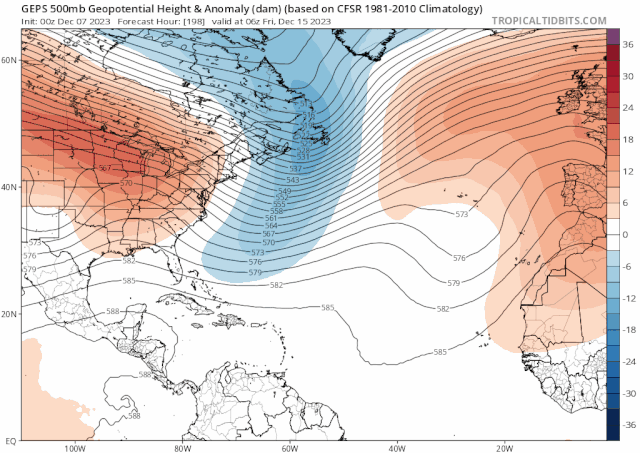
Jan week 1 is giving me big February 2021 deja vu, a pattern where small tweaks can bring big snowy surprises though I'm personally focusing from January week 2 with a bit of moving into a negative PNA at least for a time

12zs
GEPS and GEM Ensemble follows on really neatly into my post from yesterday and my general idea into January week 2
-
 9
9
-
 1
1
-
 8
8
-
- Popular Post
- Popular Post
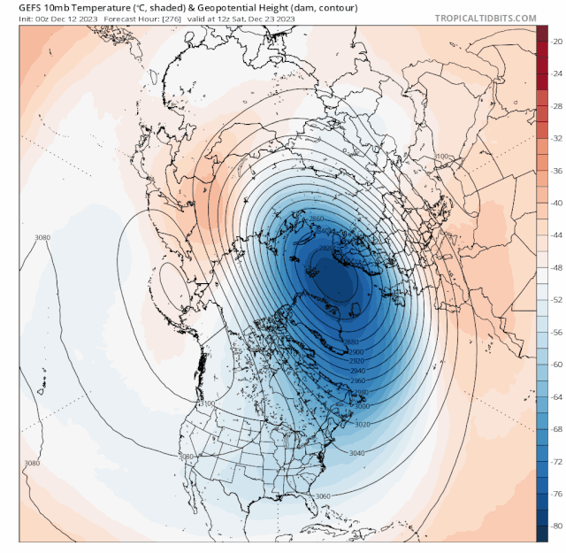
On 07/12/2023 at 15:40, Kirkcaldy Weather said:Beginning to watch as phase 5 feedback enters the scene toward December week 4 ie near Christmas, we'll be watching for the retrogressive nature of our UK and Maritime high link, this then pushes energies from the lower pressure over Greenland into trough developments further east ie to our Northwest---North---Northeast, recent emerging signs this could coincide with a re emerging Ninò Style Jet setup giving potential exciting times further beyond this timeframe if that's true


getting a feel for the C32 pattern being a distinct possibility
On 07/12/2023 at 15:40, Kirkcaldy Weather said:recent emerging signs this could coincide with a re emerging Ninò Style Jet setup giving potential exciting times further beyond this timeframe if that's true
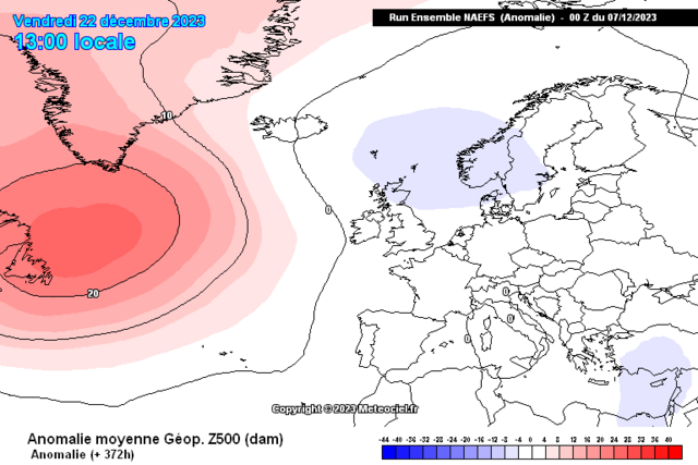
Hope everyone had a brilliant Christmas


 Super excited with this update which ties to the above statement nicely

 3 minutes ago, Kirkcaldy Weather said:
SUPER Excited to bring this update for many many reasons

 🌨🌨
🌨🌨
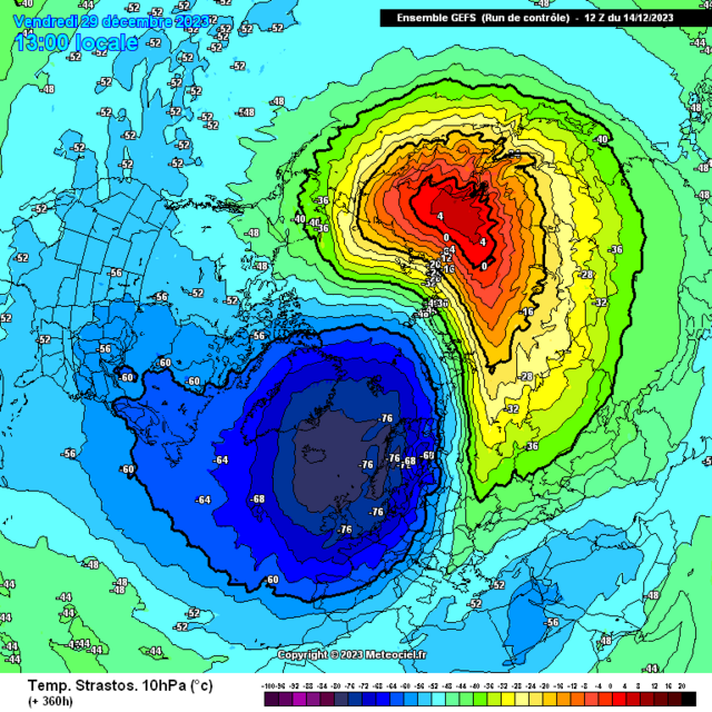
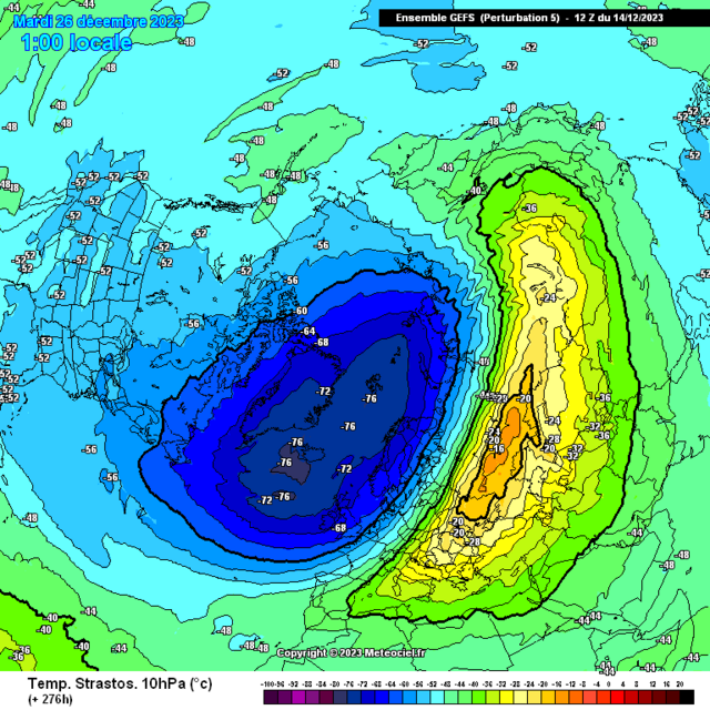
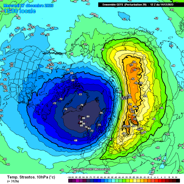
I've been working on a project for a number of months, it's focusing on a precursor of stratospheric / sudden stratospheric warmings which comes from this paper
Just a moment...
RMETS.ONLINELIBRARY.WILEY.COMSometimes the papers don't link correctly it's titled
Some of My findings to this current timeframe might need to continue adding once all my bookmarks load.
Those who regularly follow my posts will know I've shown for the past few months approx how the typical precursor setups which tend to lead into weakened vortex events and increased odds of stratospheric & sudden stratospheric warmings have been present.
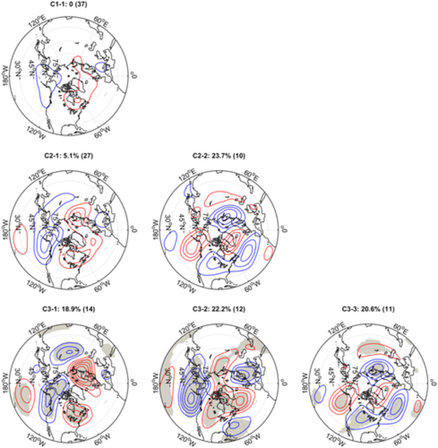
Why are we seeing a shift in the 500hpa setups progressing through January?
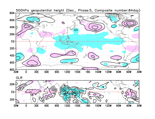
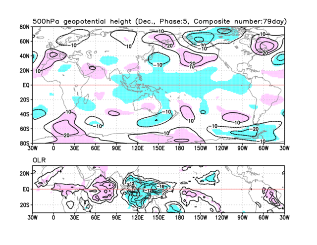
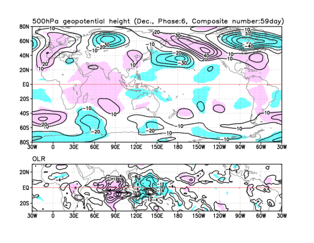
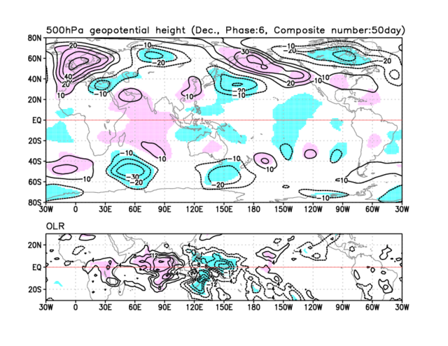
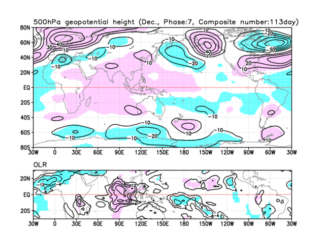
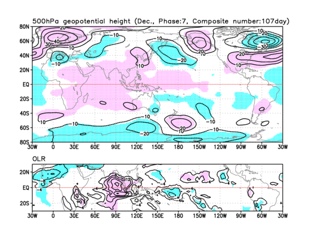
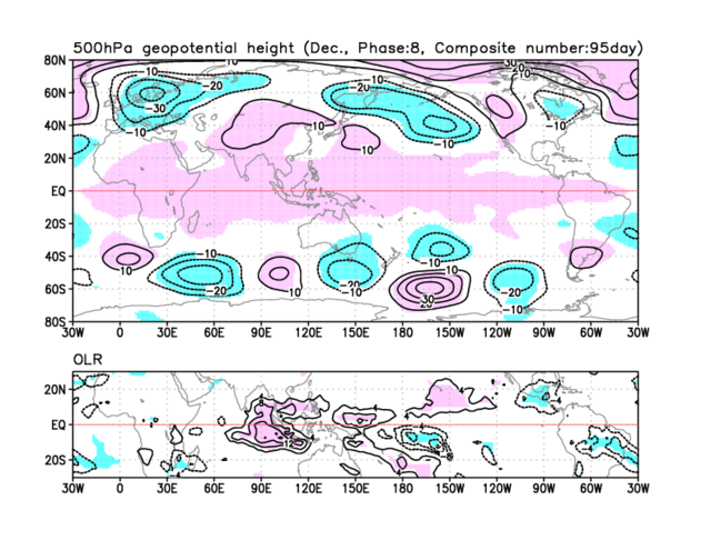
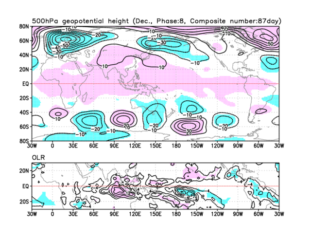
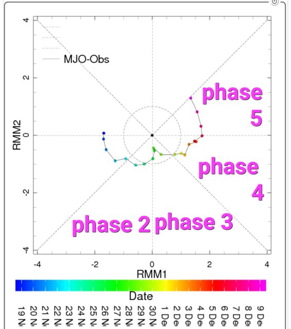
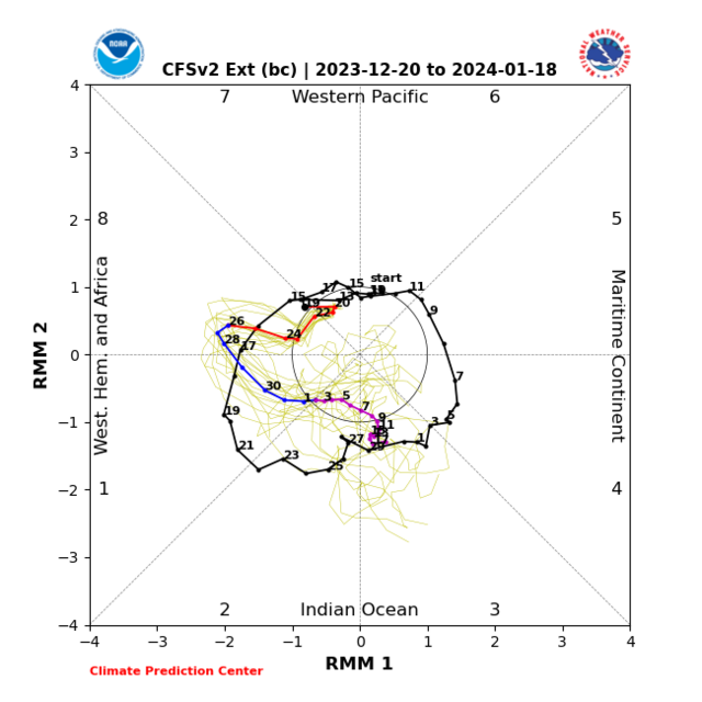
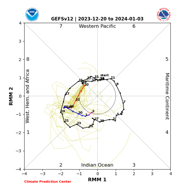
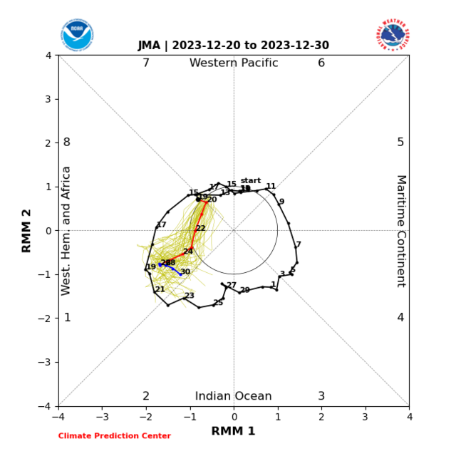
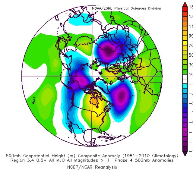
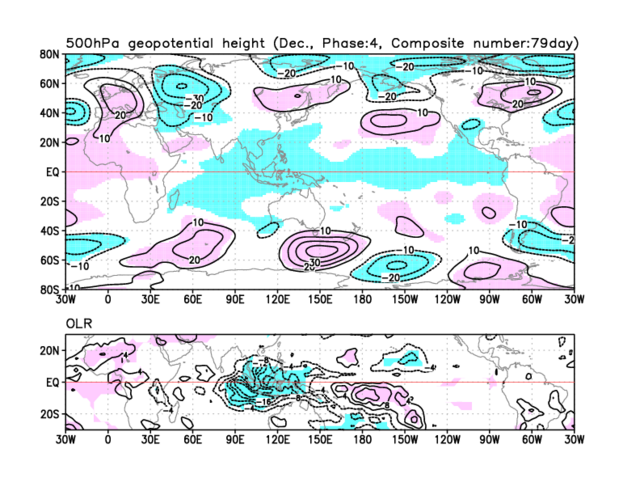
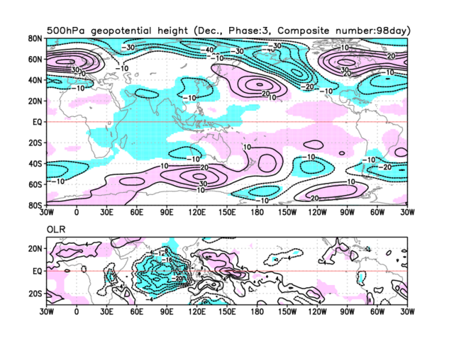
I'll begin with the MJO which will be working into the feedbacks of phases 6 through 1 generally.
With Ninò influence
Phase 6 which is fitting with the pattern we've had during recent weeks
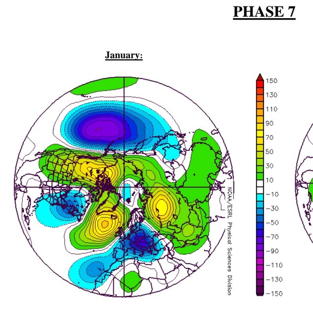
Phase 7 which again fits with recent and ongoing scenario
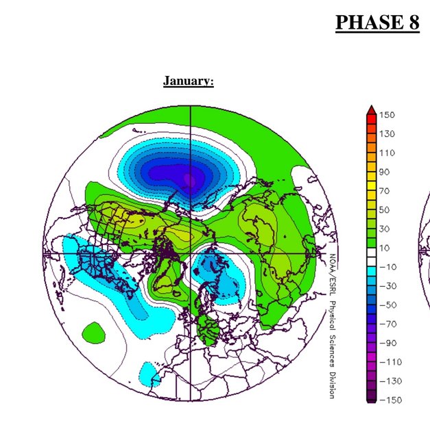
As phase 8 feedback starts this is when the pattern begins to adjust as the high from the Maritimes across Canada transitions to cyclonic developments
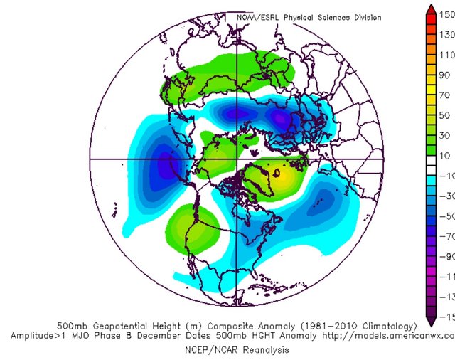
Taking the general MJO setup this transition into cyclonic development towards the Maritimes and Canada is seen with phase 6 in December too
Here is where the setup which becomes
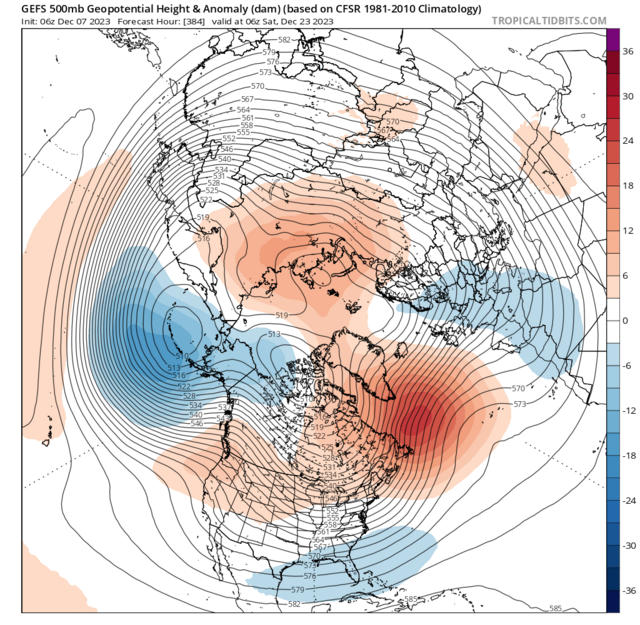
Note again our cyclonic developments from the Maritimes into Canada, troughing taking shape towards Scandinavia and the Baltics, increasing high pressure to the north of the UK. Increasing high pressure >> Blocking in Greenland
This idea is also found overall in the JMA MJO plots again phases 6 through 8
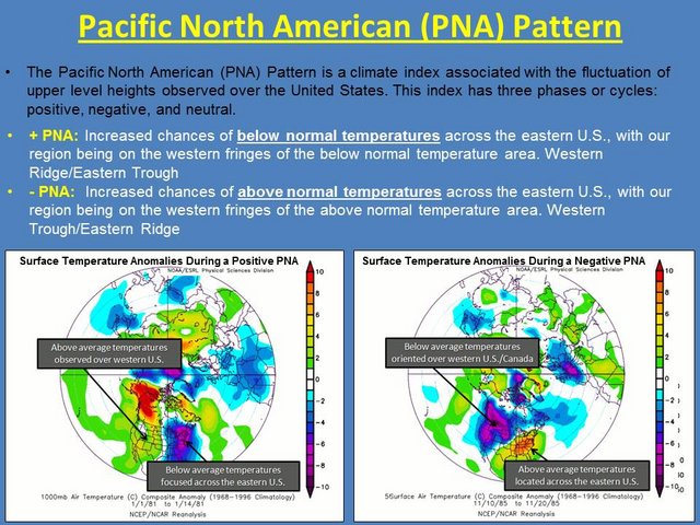
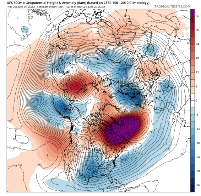
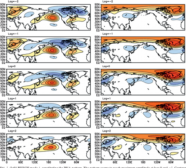
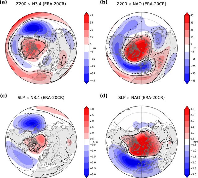
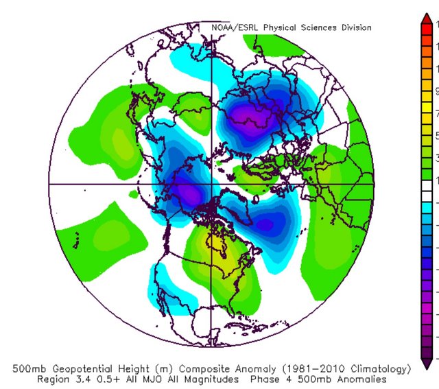
One of the biggest contributing teleconnections feeding in is the PNAPretty neat as this will feed onto a -NAO feedback which also connects great with the MJO discussion above
Awesome evolution as the high which i covered in my previous update which is bringing above average scenarios into East Asia - Korea and Japan particularly this with time transitions into a new trough which is shown in the right column above
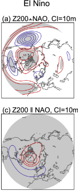
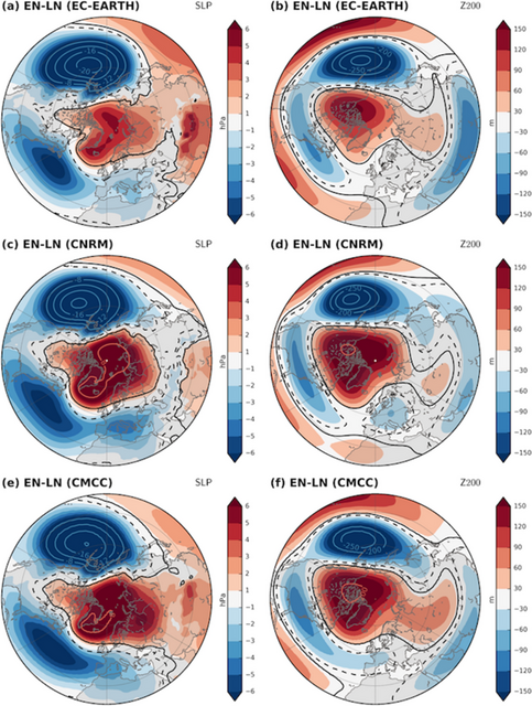
And looking closer with the El Ninò and El Ninò w SSW both are akin and tie great with all the above teleconnections input
Easterly QBO factors in again too
Plus the associated patterns with -NAO & El Ninò + -NAO
Current timing puts the MJO into the Maritimes [increased cyclonic developments noted in this post] as we get toward mid January ie latter Jan week 2
-
10
-
1
-
- Popular Post
Mega excited to give this detailed update as it contains info on a project I've been working on over the past few months


 1 minute ago, Kirkcaldy Weather said:
SUPER Excited to bring this update for many many reasons
🌨🌨
I've been working on a project for a number of months, it's focusing on a precursor of stratospheric / sudden stratospheric warmings which comes from this paper
Just a moment...
RMETS.ONLINELIBRARY.WILEY.COMSometimes the papers don't link correctly it's titled
Some of My findings to this current timeframe might need to continue adding once all my bookmarks load.
Those who regularly follow my posts will know I've shown for the past few months approx how the typical precursor setups which tend to lead into weakened vortex events and increased odds of stratospheric & sudden stratospheric warmings have been present.
Why are we seeing a shift in the 500hpa setups progressing through January?
I'll begin with the MJO which will be working into the feedbacks of phases 6 through 1 generally.
With Ninò influence
Phase 6 which is fitting with the pattern we've had during recent weeks
Phase 7 which again fits with recent and ongoing scenario
As phase 8 feedback starts this is when the pattern begins to adjust as the high from the Maritimes across Canada transitions to cyclonic developments
Taking the general MJO setup this transition into cyclonic development towards the Maritimes and Canada is seen with phase 6 in December too
Here is where the setup which becomes
Note again our cyclonic developments from the Maritimes into Canada, troughing taking shape towards Scandinavia and the Baltics, increasing high pressure to the north of the UK. Increasing high pressure >> Blocking in Greenland
This idea is also found overall in the JMA MJO plots again phases 6 through 8
One of the biggest contributing teleconnections feeding in is the PNAPretty neat as this will feed onto a -NAO feedback which also connects great with the MJO discussion above
Awesome evolution as the high which i covered in my previous update which is bringing above average scenarios into East Asia - Korea and Japan particularly this with time transitions into a new trough which is shown in the right column above
And looking closer with the El Ninò and El Ninò w SSW both are akin and tie great with all the above teleconnections input
Easterly QBO factors in again too
Plus the associated patterns with -NAO & El Ninò + -NAO
Current timing puts the MJO into the Maritimes [increased cyclonic developments noted in this post] as we get toward mid January ie latter Jan week 2
-
7
-
3
-
SUPER Excited to bring this update for many many reasons
🌨🌨
I've been working on a project for a number of months, it's focusing on a precursor of stratospheric / sudden stratospheric warmings which comes from this paper
Just a moment...
RMETS.ONLINELIBRARY.WILEY.COMSometimes the papers don't link correctly it's titled
Some of My findings to this current timeframe might need to continue adding once all my bookmarks load.
Those who regularly follow my posts will know I've shown for the past few months approx how the typical precursor setups which tend to lead into weakened vortex events and increased odds of stratospheric & sudden stratospheric warmings have been present.
Why are we seeing a shift in the 500hpa setups progressing through January?
I'll begin with the MJO which will be working into the feedbacks of phases 6 through 1 generally.
With Ninò influence
Phase 6 which is fitting with the pattern we've had during recent weeks
Phase 7 which again fits with recent and ongoing scenario
As phase 8 feedback starts this is when the pattern begins to adjust as the high from the Maritimes across Canada transitions to cyclonic developments
Taking the general MJO setup this transition into cyclonic development towards the Maritimes and Canada is seen with phase 6 in December too
Here is where the setup which becomes
Note again our cyclonic developments from the Maritimes into Canada, troughing taking shape towards Scandinavia and the Baltics, increasing high pressure to the north of the UK. Increasing high pressure >> Blocking in Greenland
This idea is also found overall in the JMA MJO plots again phases 6 through 8
On 08/11/2023 at 16:45, Kirkcaldy Weather said:Can already watch the Ninò begin to show and as January comes in the atypical Ninò 500hpa sets in
Combined to teleconnective influence of the MJO,PNA AND NAO this will feed in strengthening Blocking whilst the Ninò Jet leads to an elongating Atlantic trough
I expect January through a significant amount of February really sees the above increase
One of the biggest contributing teleconnections feeding in is the PNAPretty neat as this will feed onto a -NAO feedback which also connects great with the MJO discussion above
Awesome evolution as the high which i covered in my previous update which is bringing above average scenarios into East Asia - Korea and Japan particularly this with time transitions into a new trough which is shown in the right column above
And looking closer with the El Ninò and El Ninò w SSW both are akin and tie great with all the above teleconnections input
Easterly QBO factors in again too
Plus the associated patterns with -NAO & El Ninò + -NAO
Current timing puts the MJO into the Maritimes [increased cyclonic developments noted in this post] as we get toward mid January ie latter Jan week 2
-
1
-
-
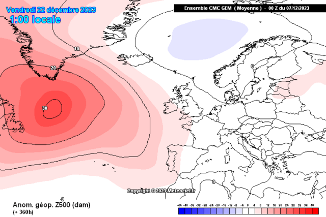
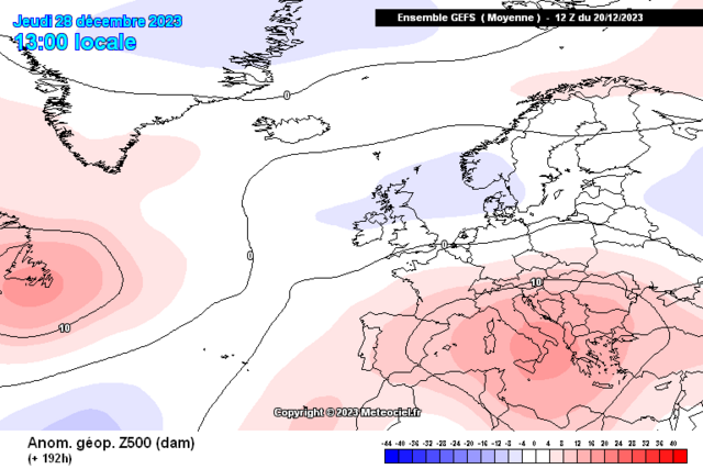
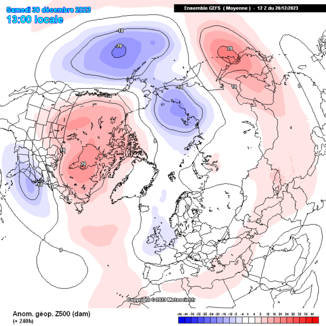
On 20/12/2023 at 18:39, Kirkcaldy Weather said:
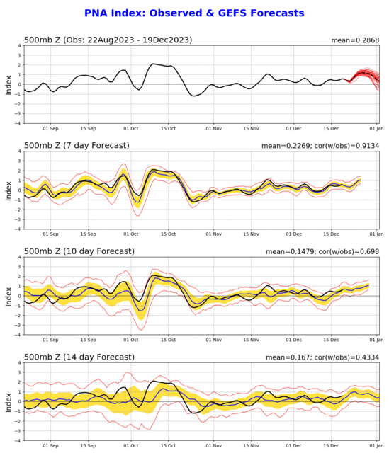
The PNA has strengthed within the + phase and this brings a new storm threat in about a weeks time
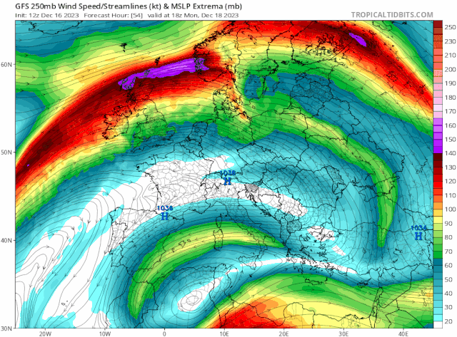
Pure stunning showcase of the +PNA setup

-
4
-
2
-
-
-
-
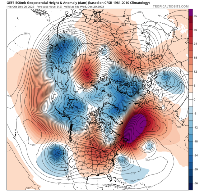
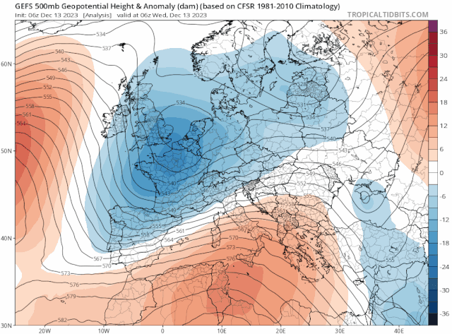
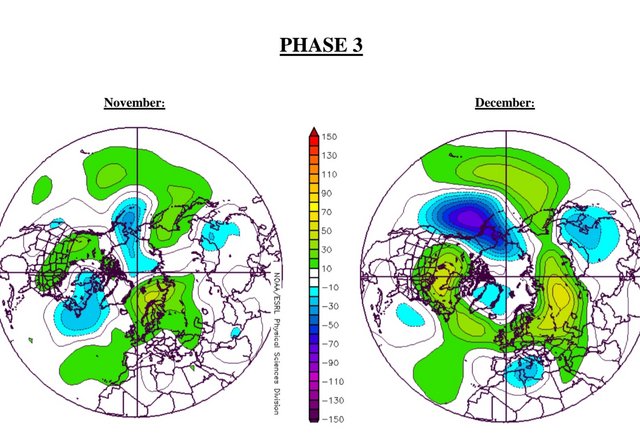
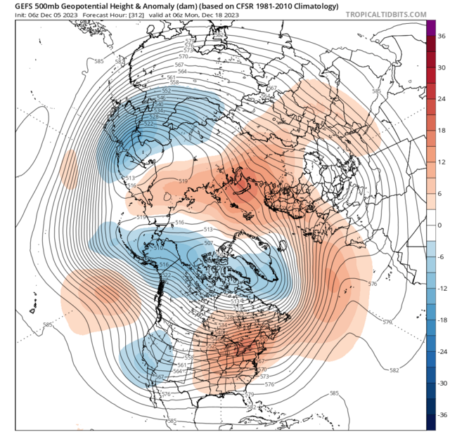
On 12/12/2023 at 18:24, Kirkcaldy Weather said:
It's all connecting really neatly from my POV which aligns to the current MJO cycling particularly phases 3 through 5/6
I mentioned the phase 3 setup would come into reality from mid December
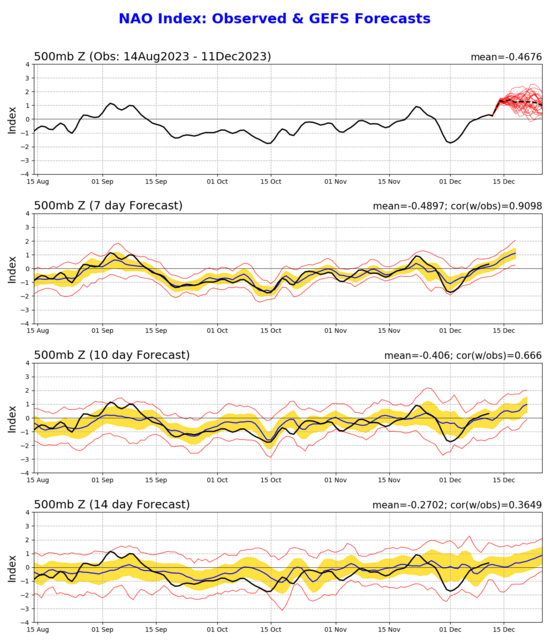
This coinciding with feedback of a positive North Atlantic Oscillation which I mentioned here
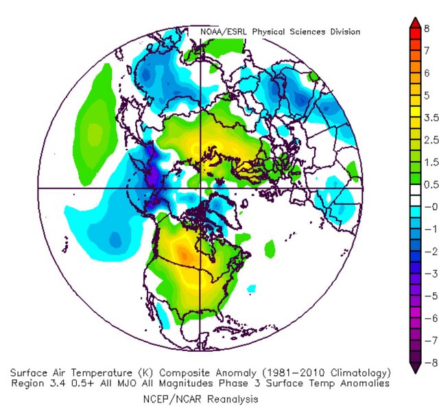
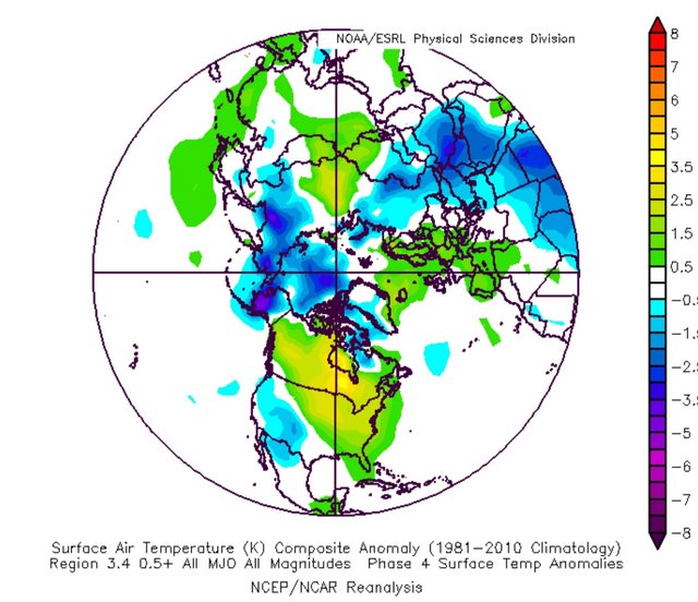
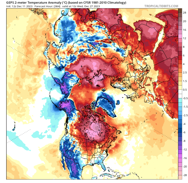
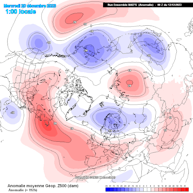
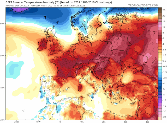
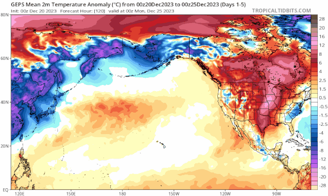
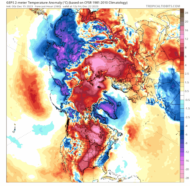
Into December week 4 it's clear to see the feedback of phases 3 and 4 which drive surface temperature patterns across most of the Northern Hemisphere into above average scenario though most significant will be where the main blocks reside particularly Canada and the Maritimes then adjacent with a secondary high toward Russia. The below average surface temperature areas will be California and Mexico, Greenland, parts of Asia and across Alaska, maybe Florida
As the phase 5 feedback comes through by Dec week 4 paired with the positive NAO and energies from the tropospheric vortex we'll need to be VERY mindful of storm developments / deep cyclones

Use these as a general idea
Not surprising too watching as some strat warming is appearing also into Dec week 4 which was a timeframe ive had in my mind since Nov week 4
On 20/12/2023 at 18:39, Kirkcaldy Weather said:Very detailed post incoming
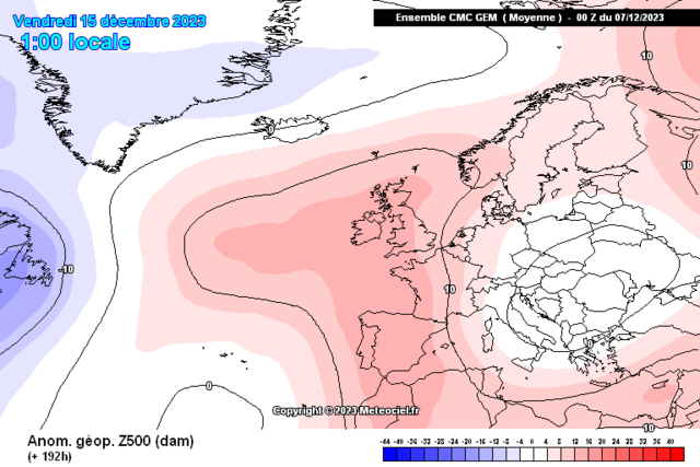
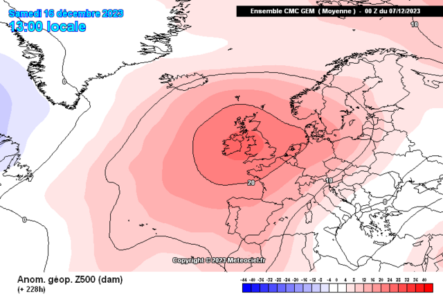
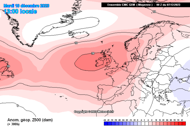
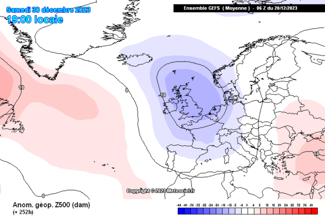
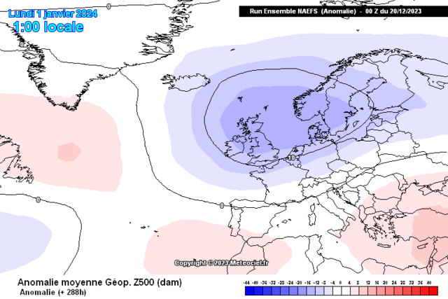
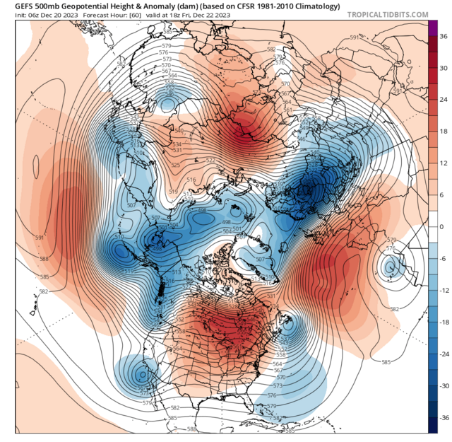
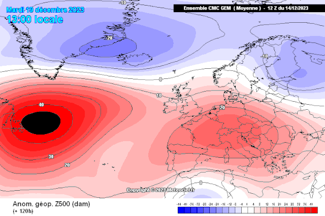
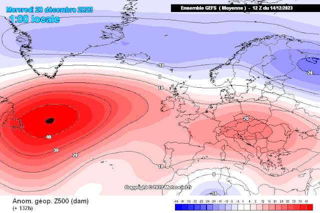
My thinking holds steady with the pattern evolutions over the Christmas and heading toward the New year period, the broadscale setup is that of a developing Scandinavian - Baltic trough, this setup was always probable into week 4 of December
perfect timing with your post @Jo Farrow thanks


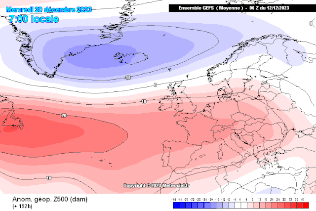
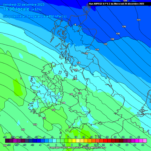
Looking solely into the dynamical situations for Christmas itself as mentioned in my posts above / recently the highest probalistic outcomes of below average surface temps were always best for northern UK
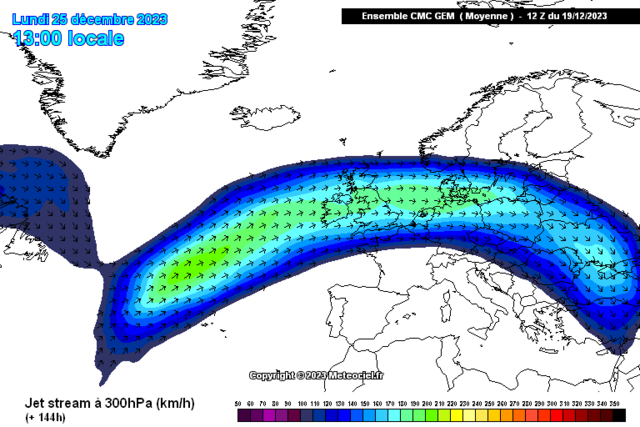
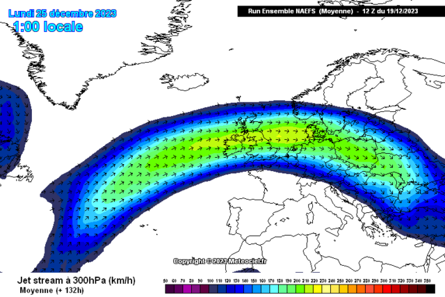
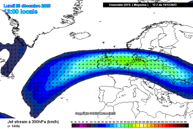
With a prominent section of the Jet crossing the UK its easy to understand the milder trends particularly on the southern flank
Also easy seeing why the flow will change orientation from a Northwest flow to that of more Westerly influence which again you'd not typically connect with prolonged below avg weather.
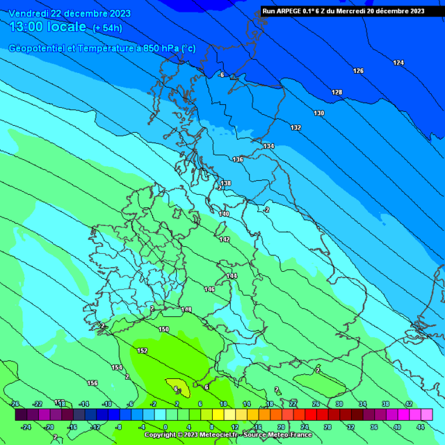
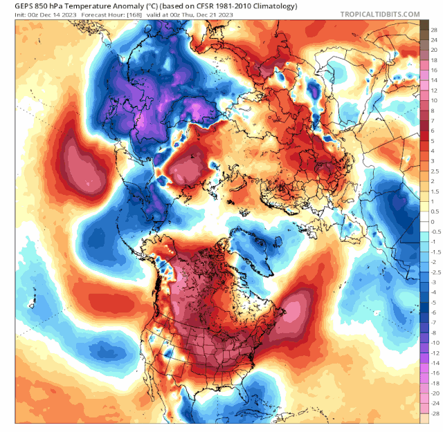
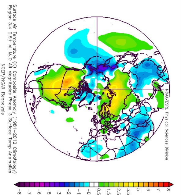
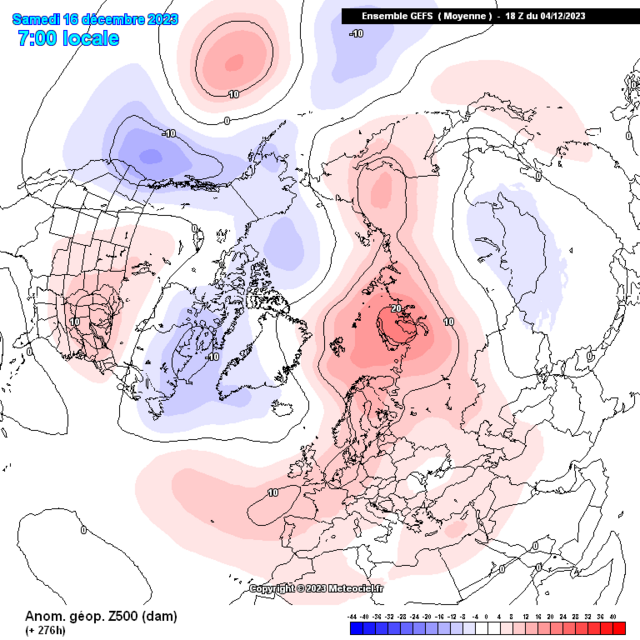
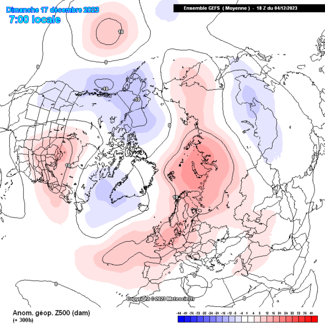
850hpa anoms
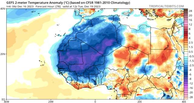
Surface temperatures anomalies
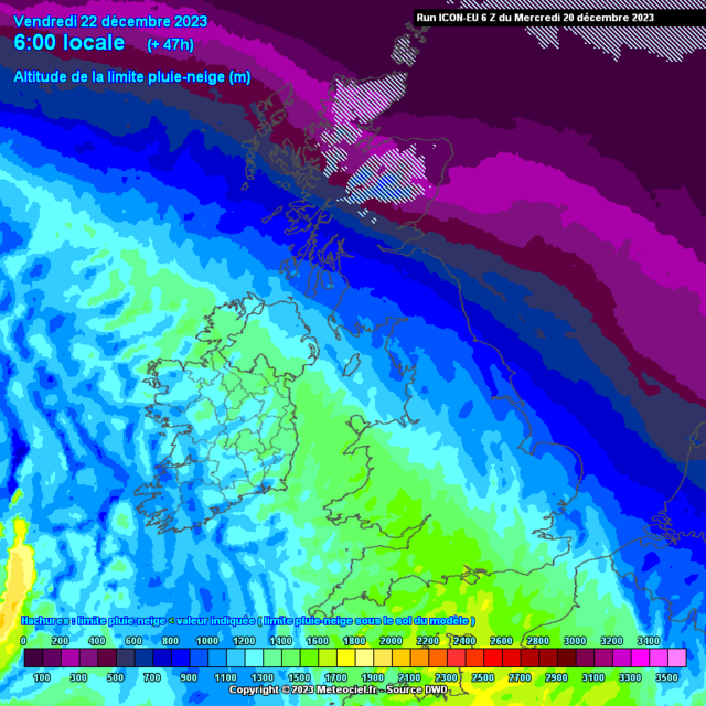
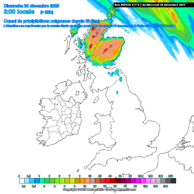
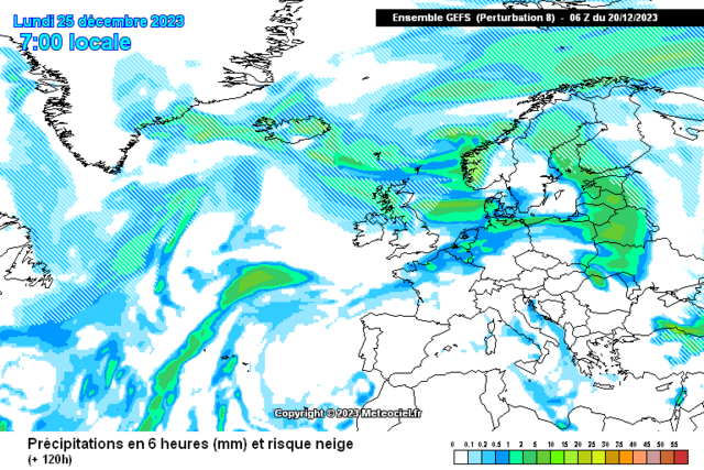
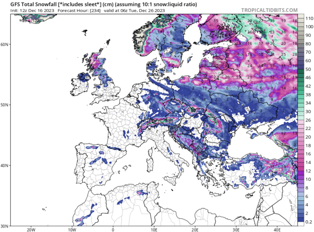
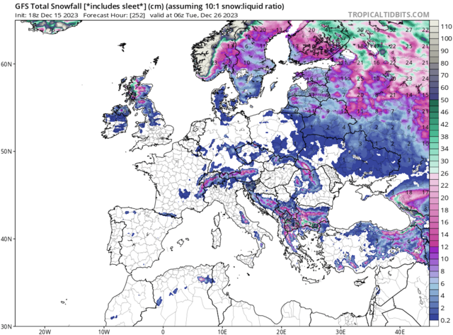
Looks like a legit chance of a snow event particularly for the northern,northwestern and Northeastern sections of Scotland through Friday and Sat with precip forming along the frontal boundary between the cold and warm air
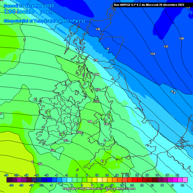
For Christmas itself current trends show a feature starting across Northern Scotland which moves south sometime on Christmas Day, this might bring an opportunity for a classic white Christmas dependant on 528 dam position and Dewpoints feeding into said feature.

Looking further into what's unfolding further afield, as the MJO is progressing through the Western Hemisphere and Africa I'd be expectant for some cyclonic developments within these regions and lo and behold we see a double rossby wave break over Africa with the 1st giving snowfall in Algeria and the 2nd bringing a persisting low over Morocco which might also see some snowfall there.
This should help to develop further lows toward the UK in the run up to New Year
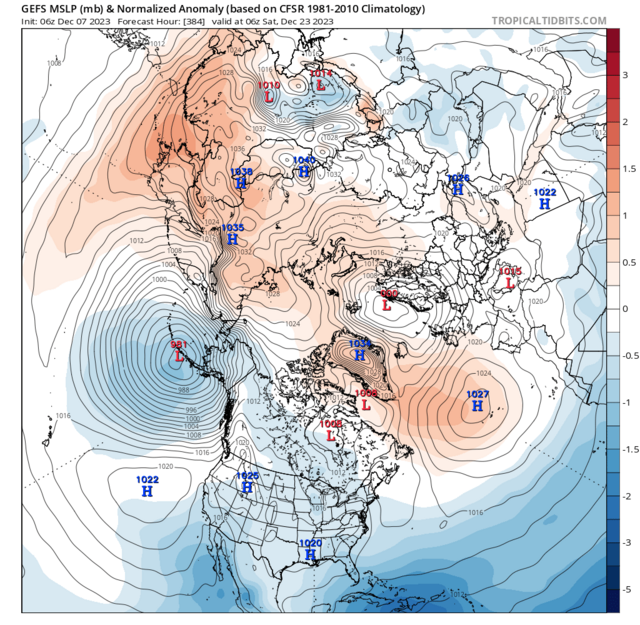
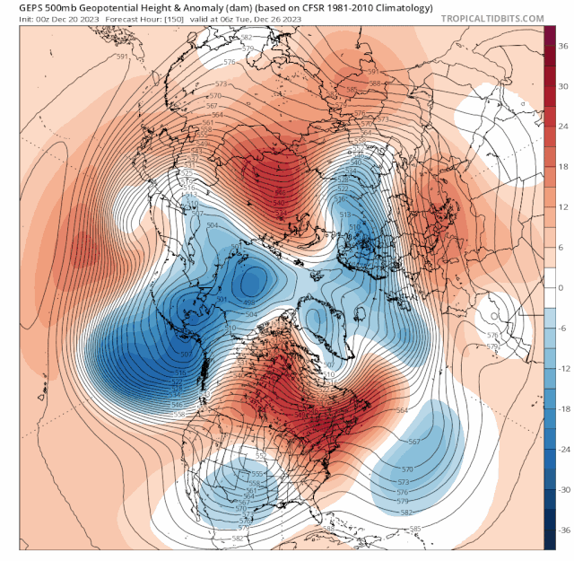
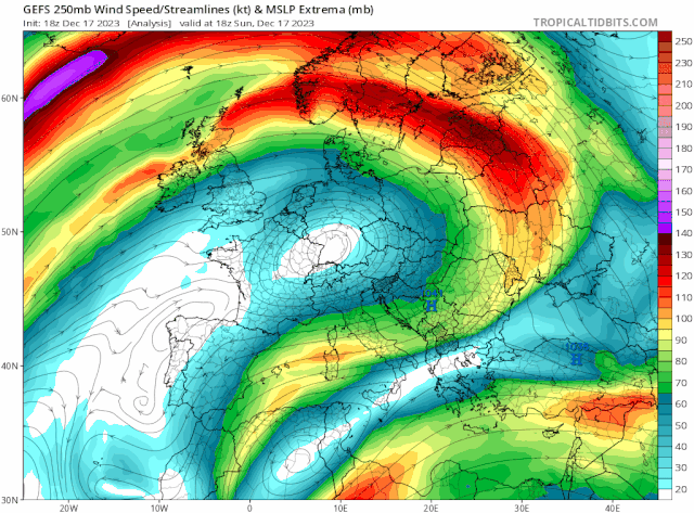
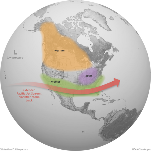
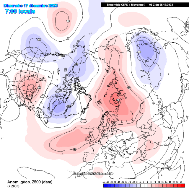
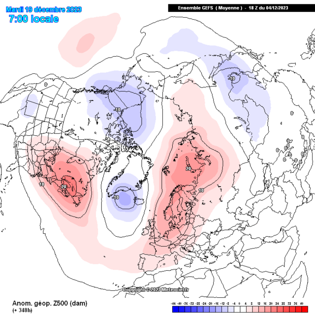
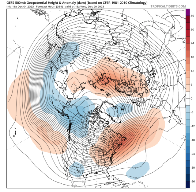
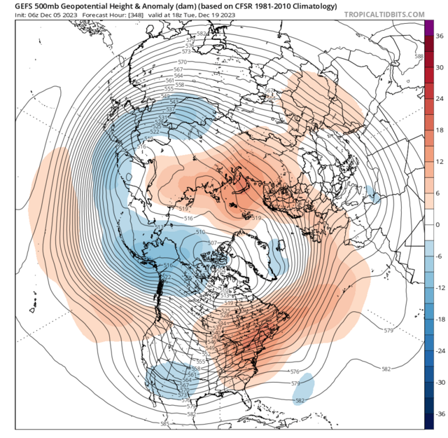
In my post from 7th December I spoke of the re emerging trend of a classic El Ninò Style Jet, this paired with the PNA being positive .. more on that in a min. Has already given a record breaking storm on that route via the Gulf into the Northeast
Looking back at what I discussed from December 5th
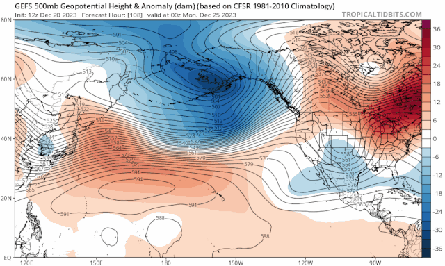
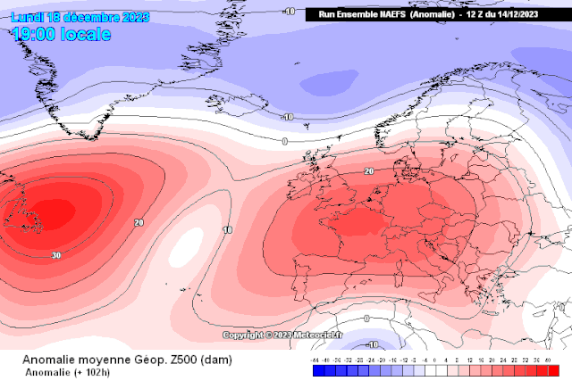
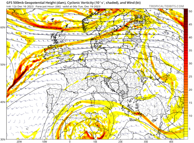
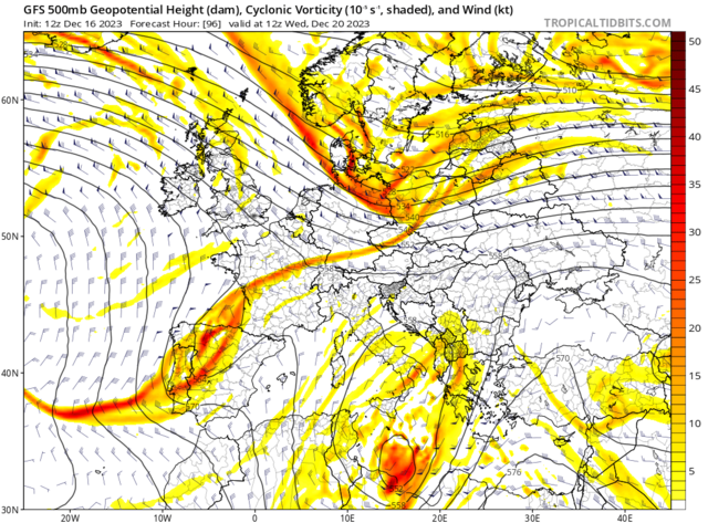
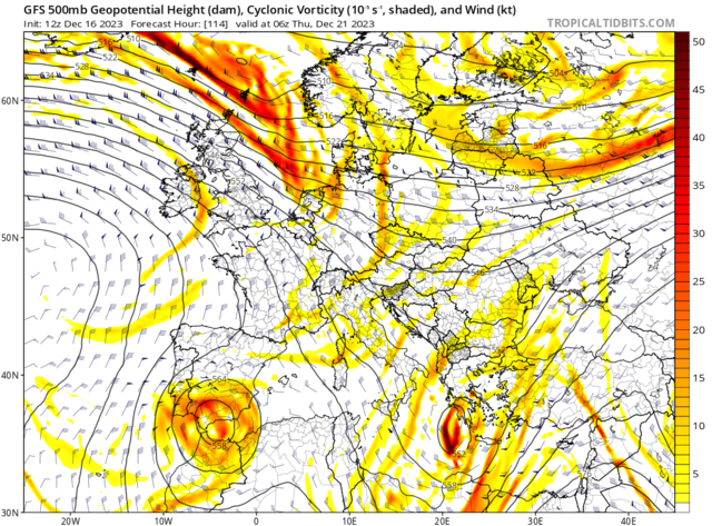
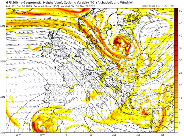
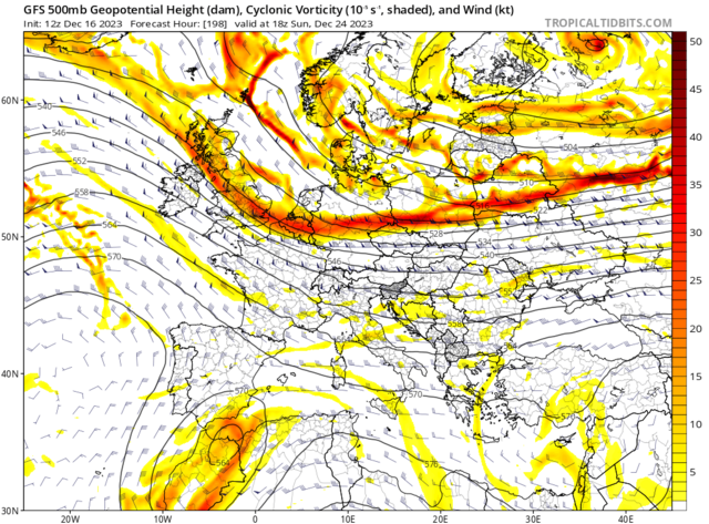
Excellent representation with the ongoing and in parts record strength block particularly through the UK, North Atlantic and Maritimes--> Canada
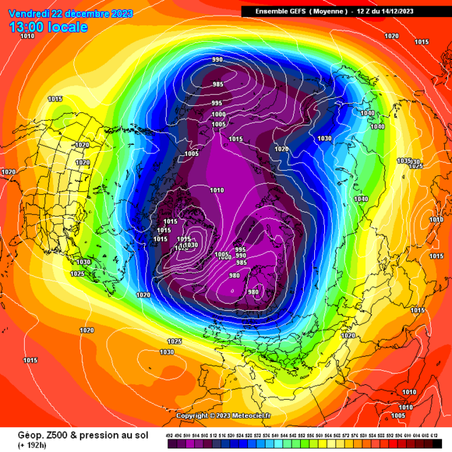
also we now have our cut off low development through California into Mexico
The PNA has strengthed within the + phase and this brings a new storm threat in about a weeks time
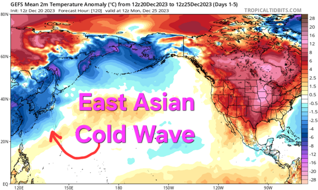
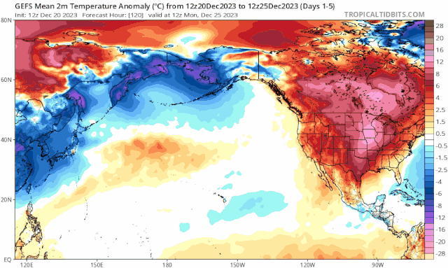
I'm expectant of a shift from the deep cold which has and is currently residing across Asia, East Asia particularly as high pressure moves across Korea and Japan through Christmas this switches towards above average temperature scenarios
"As the phase 5 feedback comes through by Dec week 4 paired with the positive NAO and energies from the tropospheric vortex we'll need to be VERY mindful of storm developments / deep cyclones
"
'Looks like a legit chance of a snow event particularly for the northern,northwestern and Northeastern sections of Scotland through Friday and Sat with precip forming along the frontal boundary between the cold and warm air"
Pleasing seeing all the snow reports from our residential correspondence members in said areas
@Scottish-Irish Skier I was like  how's he posting snowy snaps having forgot you've snuck off into Aberdeenshire
'For Christmas itself current trends show a feature starting across Northern Scotland which moves south sometime on Christmas Day, this might bring an opportunity for a classic white Christmas dependant on 528 dam position and Dewpoints feeding into said feature."
Main story into Christmas is all dependant on a development of a frontal wave, currently this looks like developments begin to our west by early Christmas morning as the big fella brings our

As discussed above we still see the prominence of a section of the Jet across the UK which looks to position favourably as this frontal wave forms combining with another boundary setup which @Hawesy has described as was present with the Fri-Sat snow.
Looks to see this wave developing increasing precipitation rates and with increasingly chillier 850s beginning to undercut, where the dewpoints start to become increasingly supportive this sees the change over into snow with current signs from Perth, maybe Cairngorm and over near Dundee possible extention outwith.
I'll be mega surprised if we aren't sitting with at least yellow snow warning covering this waving activity. Once the pivot and movement further south southeastwards begins this coinciding as the -4/-5 850hpa really undercuts which really increases the opportunity for a quite significant snow event into parts of central Scotland and into Stirling, Fife and eventual progression towards Edinburgh etc etc
'If this tendency persists and the wave increases in size, a cyclonic (counterclockwise) circulation develops. One section of the front begins to move as a warm front, while the section next to it begins to move as a cold front (C). This deformation is a frontal wave.
The pressure at the peak of the frontal wave falls, and a low-pressure center forms. The cyclonic circulation becomes stronger, and the surface winds are now strong enough to move the fronts; the cold front moves faster than the warm front (D). When the cold front catches up with the warm front, the two of them occlude (close together). The result is an occluded front or, for brevity, an occlusion (E). This is the time of maximum intensity for the wave cyclone. Note that the symbol depicting the occlusion is a combination of the symbols for the warm and cold fronts.
As the occlusion continues to grow in length, the cyclonic circulation diminishes in intensity and the frontal movement slows down (F). Sometimes a new frontal wave begins to form on the long westward-trailing portion of the cold front (F,G), or a secondary low pressure system forms at the apex where the cold front and warm front come together to form the occlusion. In the final stage, the two fronts may have become a single stationary front again.'
Well this is a brilliant example of the complexities involved with newest data suggesting the boundary remains North of the central zones with biggest impact over Cairngorms etc
Quite incredible and shows that even within 24hr range these multi million pound / dollar supercomputers still struggle in setups such as these.
12z
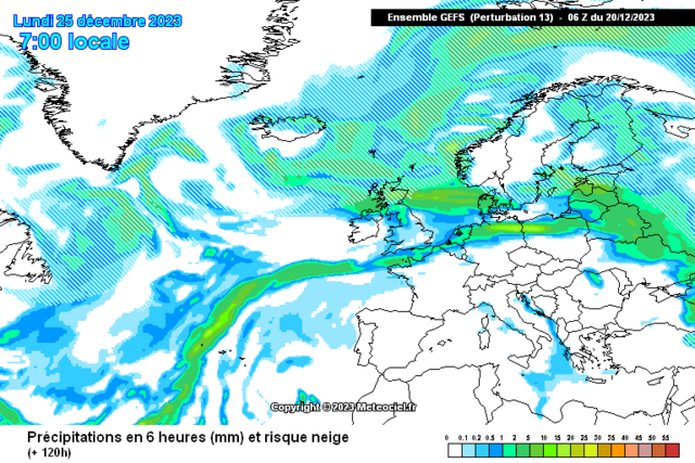
"Looking further into what's unfolding further afield, as the MJO is progressing through the Western Hemisphere and Africa I'd be expectant for some cyclonic developments within these regions and lo and behold we see a double rossby wave break over Africa with the 1st giving snowfall in Algeria and the 2nd bringing a persisting low over Morocco which might also see some snowfall there. This should help to develop further lows toward the UK in the run up to New Year'
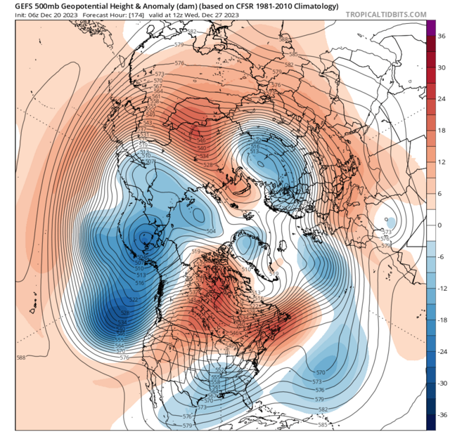
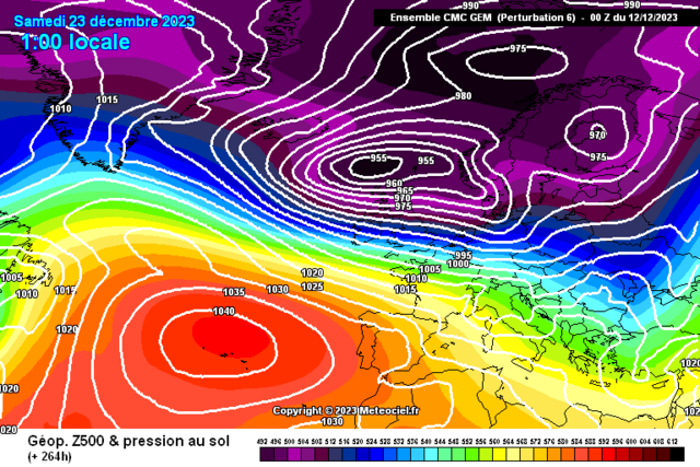
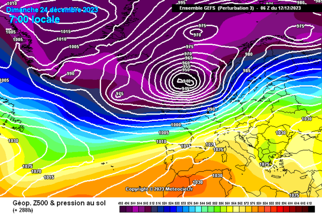
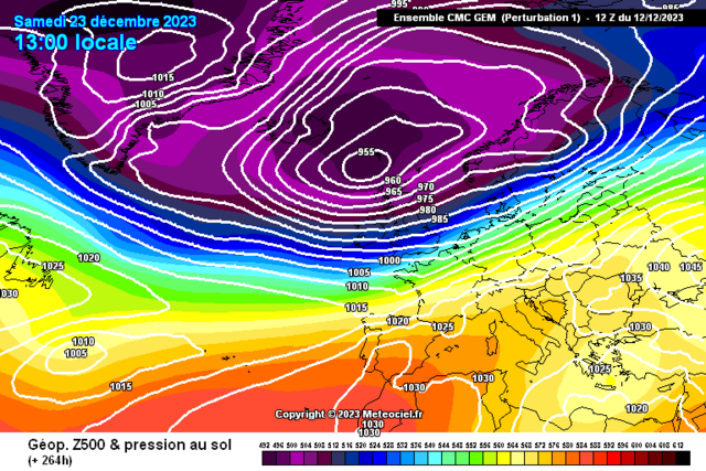
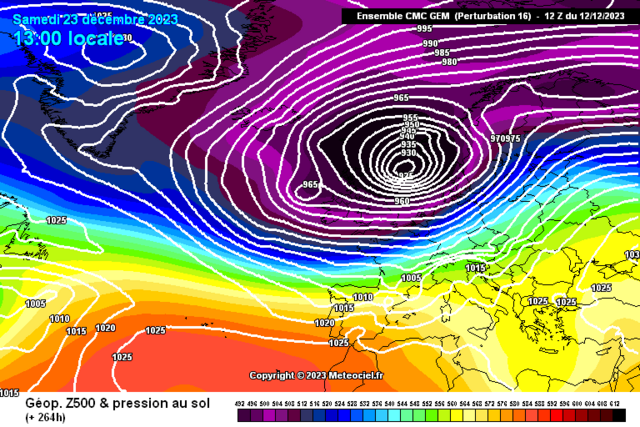
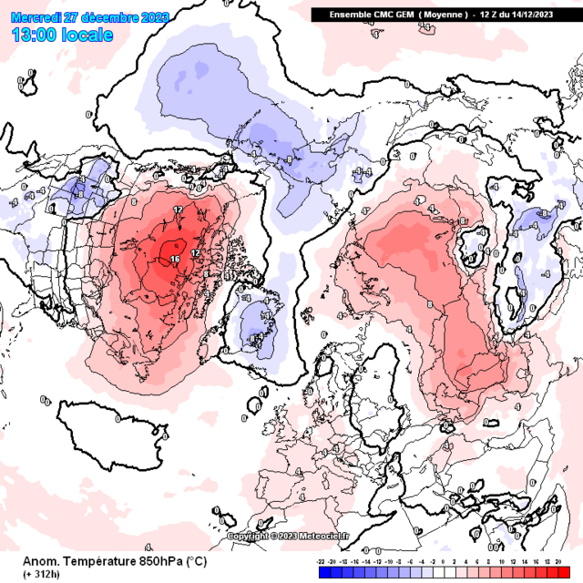
Yep, we've got an initial cyclone coming in by the 27th with a number of impactful conditions.
High Ground Snowfall on the leading edge
Jet increasing in strength
Looks like we'll need to be very alert for impacts from Gales from a Southeast direction initially on the 27th
Getting some Arwen esque vibes into the 28th once this cyclone transfers over into the North Sea, might be some impactful wraparound gales from similar directions as Arwen
I think the meteorological agencies over in the Netherlands, North Germany,Poland and perhaps Denmark will be concerned with this system.
-
8
-
1
-
-
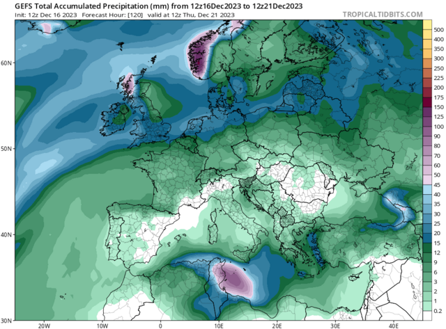
0.7C with 76.6MM please
-
-
-
-
-
On 20/12/2023 at 18:39, Kirkcaldy Weather said:
Very detailed post incoming
My thinking holds steady with the pattern evolutions over the Christmas and heading toward the New year period, the broadscale setup is that of a developing Scandinavian - Baltic trough, this setup was always probable into week 4 of December
perfect timing with your post @Jo Farrow thanks
Looking solely into the dynamical situations for Christmas itself as mentioned in my posts above / recently the highest probalistic outcomes of below average surface temps were always best for northern UK
With a prominent section of the Jet crossing the UK its easy to understand the milder trends particularly on the southern flank
Also easy seeing why the flow will change orientation from a Northwest flow to that of more Westerly influence which again you'd not typically connect with prolonged below avg weather.
850hpa anoms
Surface temperatures anomalies
Looks like a legit chance of a snow event particularly for the northern,northwestern and Northeastern sections of Scotland through Friday and Sat with precip forming along the frontal boundary between the cold and warm air
For Christmas itself current trends show a feature starting across Northern Scotland which moves south sometime on Christmas Day, this might bring an opportunity for a classic white Christmas dependant on 528 dam position and Dewpoints feeding into said feature.
Looking further into what's unfolding further afield, as the MJO is progressing through the Western Hemisphere and Africa I'd be expectant for some cyclonic developments within these regions and lo and behold we see a double rossby wave break over Africa with the 1st giving snowfall in Algeria and the 2nd bringing a persisting low over Morocco which might also see some snowfall there.
This should help to develop further lows toward the UK in the run up to New Year
In my post from 7th December I spoke of the re emerging trend of a classic El Ninò Style Jet, this paired with the PNA being positive .. more on that in a min. Has already given a record breaking storm on that route via the Gulf into the Northeast
Looking back at what I discussed from December 5th
Excellent representation with the ongoing and in parts record strength block particularly through the UK, North Atlantic and Maritimes--> Canada
also we now have our cut off low development through California into Mexico
The PNA has strengthed within the + phase and this brings a new storm threat in about a weeks time
I'm expectant of a shift from the deep cold which has and is currently residing across Asia, East Asia particularly as high pressure moves across Korea and Japan through Christmas this switches towards above average temperature scenarios
-
-
-
-
Newest Update
 1 minute ago, Kirkcaldy Weather said:
Very detailed post incoming
My thinking holds steady with the pattern evolutions over the Christmas and heading toward the New year period, the broadscale setup is that of a developing Scandinavian - Baltic trough, this setup was always probable into week 4 of December
perfect timing with your post @Jo Farrow thanks
Looking solely into the dynamical situations for Christmas itself as mentioned in my posts above / recently the highest probalistic outcomes of below average surface temps were always best for northern UK
With a prominent section of the Jet crossing the UK its easy to understand the milder trends particularly on the southern flank
Also easy seeing why the flow will change orientation from a Northwest flow to that of more Westerly influence which again you'd not typically connect with prolonged below avg weather.
850hpa anoms
Surface temperatures anomalies
Looks like a legit chance of a snow event particularly for the northern,northwestern and Northeastern sections of Scotland through Friday and Sat with precip forming along the frontal boundary between the cold and warm air
For Christmas itself current trends show a feature starting across Northern Scotland which moves south sometime on Christmas Day, this might bring an opportunity for a classic white Christmas dependant on 528 dam position and Dewpoints feeding into said feature.
Looking further into what's unfolding further afield, as the MJO is progressing through the Western Hemisphere and Africa I'd be expectant for some cyclonic developments within these regions and lo and behold we see a double rossby wave break over Africa with the 1st giving snowfall in Algeria and the 2nd bringing a persisting low over Morocco which might also see some snowfall there.
This should help to develop further lows toward the UK in the run up to New Year
In my post from 7th December I spoke of the re emerging trend of a classic El Ninò Style Jet, this paired with the PNA being positive .. more on that in a min. Has already given a record breaking storm on that route via the Gulf into the Northeast
Looking back at what I discussed from December 5th
Excellent representation with the ongoing and in parts record strength block particularly through the UK, North Atlantic and Maritimes--> Canada
also we now have our cut off low development through California into Mexico
The PNA has strengthed within the + phase and this brings a new storm threat in about a weeks time
I'm expectant of a shift from the deep cold which has and is currently residing across Asia, East Asia particularly as high pressure moves across Korea and Japan through Christmas this switches towards above average temperature scenarios
-
7
-
2
-
-
- Popular Post
Very detailed post incoming
My thinking holds steady with the pattern evolutions over the Christmas and heading toward the New year period, the broadscale setup is that of a developing Scandinavian - Baltic trough, this setup was always probable into week 4 of December
On 07/12/2023 at 15:40, Kirkcaldy Weather said:Beginning to watch as phase 5 feedback enters the scene toward December week 4 ie near Christmas, we'll be watching for the retrogressive nature of our UK and Maritime high link, this then pushes energies from the lower pressure over Greenland into trough developments further east ie to our Northwest---North---Northeast, recent emerging signs this could coincide with a re emerging Ninò Style Jet setup giving potential exciting times further beyond this timeframe if that's true
getting a feel for the C32 pattern being a distinct possibility
On 15/12/2023 at 14:42, Kirkcaldy Weather said:Extending from my latest update here
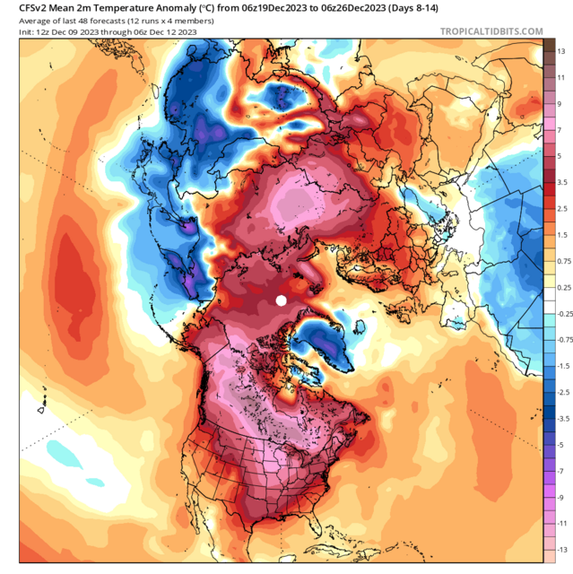
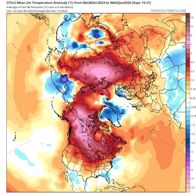
With the continuation of positive NAO feedback paired to recent MJO phases favouring an above average temperature scenarios there won't be any significant long lasting below average temperatures however as phase 5 feeds into the positive NAO in around 6/7 days time this will bring the tropospheric vortex stretching from the Alaskan trough into the Standard below average heights from Greenland and into the phase 5 setup with this extending across to Scandinavia
The biggest surface temperature anoms below average for the UK are most probable across northern Britain
Below avg 850hpa temperatures will extend across a wide swathe of the UK and into Scandinavia
This below average period will face a quick retraction once again as the trough becomes refocused further north northwest back toward Greenland as colder conditions once again becoming focused in Asia, California, Alaska, Greenland, potentially Florida plus Mexico
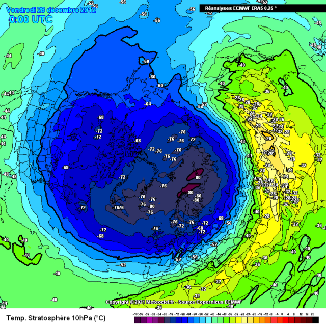
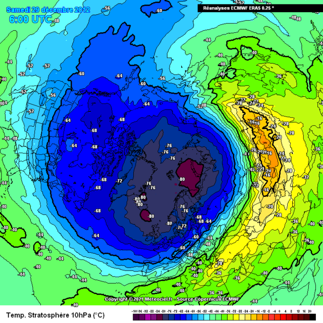
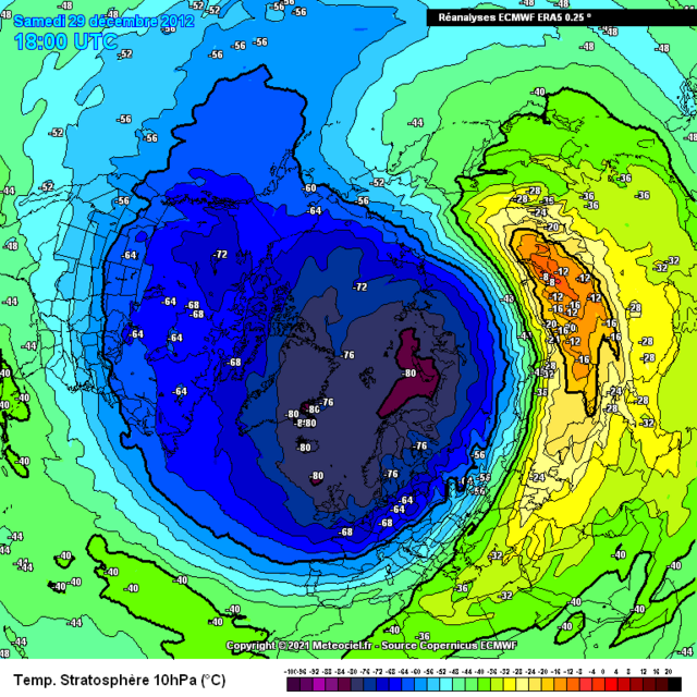
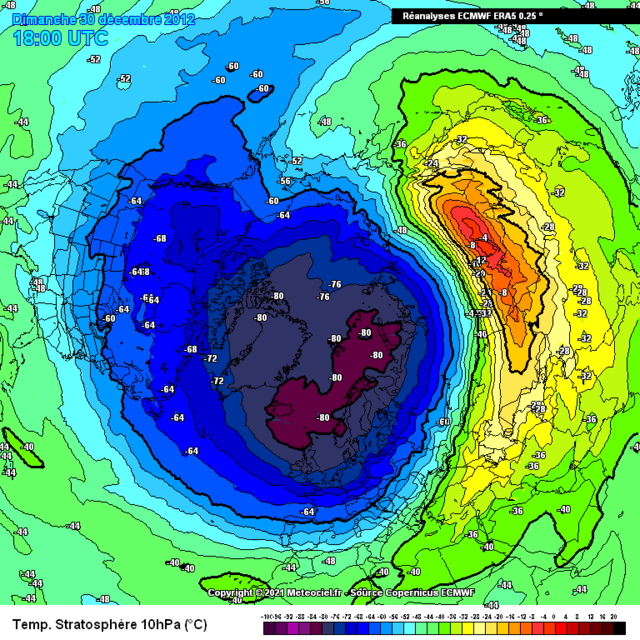
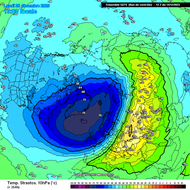
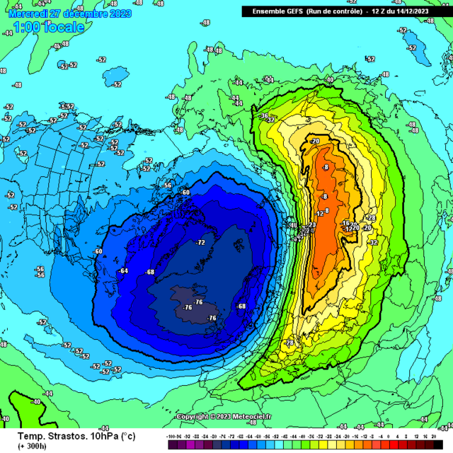
Further synchronicity with 2012
perfect timing with your post @Jo Farrow thanks
7 hours ago, Jo Farrow said:Seems that the DMI Danish met have named it Pia
Looking solely into the dynamical situations for Christmas itself as mentioned in my posts above / recently the highest probalistic outcomes of below average surface temps were always best for northern UK
With a prominent section of the Jet crossing the UK its easy to understand the milder trends particularly on the southern flank
Also easy seeing why the flow will change orientation from a Northwest flow to that of more Westerly influence which again you'd not typically connect with prolonged below avg weather.
850hpa anoms
Surface temperatures anomalies
Looks like a legit chance of a snow event particularly for the northern,northwestern and Northeastern sections of Scotland through Friday and Sat with precip forming along the frontal boundary between the cold and warm air
For Christmas itself current trends show a feature starting across Northern Scotland which moves south sometime on Christmas Day, this might bring an opportunity for a classic white Christmas dependant on 528 dam position and Dewpoints feeding into said feature.
Looking further into what's unfolding further afield, as the MJO is progressing through the Western Hemisphere and Africa I'd be expectant for some cyclonic developments within these regions and lo and behold we see a double rossby wave break over Africa with the 1st giving snowfall in Algeria and the 2nd bringing a persisting low over Morocco which might also see some snowfall there.
On 16/12/2023 at 17:49, Kirkcaldy Weather said:Looking at the situation across Africa particularly Northwest North and Northeast regions, a low which began in SE England will transition into a cut off low via Rossby Wave Breaking and will drift Southwest into Africa. This is occuring via feedbacks of phase 3 of the MJO which can give below average surface temps across these African regions which matches very good to these upcoming dynamics
New trend coming into play on the models with scope of a second wave break from frontal energy coming from the Atlantic which extends Northeast through the UK with signs for a secondary cut off low development through Spain which also slides into these African regions
Contradictory to the Christmas lyrics this will provide opportunity for some of the precip to be falling as snow in parts of Morocco, Northern Alergia and Tunisia this Christmas
Could be some flooding rains with the first wave breaking low over Tunisia in particular which might extend toward the Libyan coastlines
On 17/12/2023 at 22:32, Kirkcaldy Weather said:
This should help to develop further lows toward the UK in the run up to New Year
In my post from 7th December I spoke of the re emerging trend of a classic El Ninò Style Jet, this paired with the PNA being positive .. more on that in a min. Has already given a record breaking storm on that route via the Gulf into the Northeast
Looking back at what I discussed from December 5th
On 05/12/2023 at 18:43, Kirkcaldy Weather said:I've posted a detailed look at the incredible event of the previous 11 days

 🌨🌨
🌨🌨 ️️
️️
Following onto the prior posts in this thread we continue to watch as classic feedback from phases 2 through 4 emerge
Multiple patterns unfolding here.
Elongation of high heights north of Hawaii, Extending trough from Alaska down the west coast which leads to development of cut off low(s) from California and especially Mexico, Strengthening Block in the far north of America and particularly East Canada into Maritmes with the curved extension to the UK and Scandinavia. As phase 4 feeds in this brings high pressure into the UK from the Southwest with a trough to the east
Feedback of progress into a + NAO
Excellent representation with the ongoing and in parts record strength block particularly through the UK, North Atlantic and Maritimes--> Canada
also we now have our cut off low development through California into Mexico
The PNA has strengthed within the + phase and this brings a new storm threat in about a weeks time
I'm expectant of a shift from the deep cold which has and is currently residing across Asia, East Asia particularly as high pressure moves across Korea and Japan through Christmas this switches towards above average temperature scenarios
-
8
-
6
-
-
-


Record Breaking / Abnormal Weather Events Globally
in Hurricanes, Cyclones and Extreme weather worldwide
Posted