


mpkio2
-
Posts
224 -
Joined
-
Last visited
Content Type
Forums
Blogs
Gallery
Events
Learn About Weather and Meteorology
Community guides
Posts posted by mpkio2
-
-
7 minutes ago, chrisbell-nottheweatherman said:
Indeed, but the individual members diverge around the 17th, so making bold pronouncements on the expected situation beyond then is, IMO, pointless; one can speculate or discuss the possibilities, but I've read at least one "nailed-on" comment here today regarding the 18th and 19th which seems premature given the uncertainty from Friday onwards.
Yup, agreed.
Good that the Op and Control are in syn, but noting is "nailed on" yet.
I'm keeping positive because many models are singing from the same hymn sheet re cold pattern potentially setting up.
")
But I'm still cautious until we get nearer to 17th Novememberand see what the models say then.
Still keeping the faith, chaps!
-
 1
1
-
-
Some very nice output on todays12z suites!
The positive today is that the UKMO has dropped its previous runs pattern and joined GFS/ECM!
However, I'm still not buying into anything post 17th November because past that point is FL territory.
Some nice eye candy charts though!
-
 8
8
-
1
-
-
I don't usually ramp, but...
12z GFS 11/11 t216:
Man, that is a STONKER!!!!
One solution out of many and all for fun at this stage, of course!
-
6
-
1
-
-
3 minutes ago, karyo said:
The long road to cold should always be avoided unless it is the only road. The longer it takes the more things can go wrong.
The 12z GFS doesn't go the UKMO route. It has a weaker Atlantic block than the 6z but somehow the northwesterly at the end of next week delivers colder uppers to the UK.
Yeah, I completely agree with you.
It's a route we (Coldies!) don't want to take if need be. GFS/ECM route is much easier, I think.
Also, speaking of UKMO, it's ditched it's 06z pattern!
12z UKMO 11/11 t144:
Looking very much like the 12z GFS!
12z GFS 11/11 t144:
-
3
-
-
To be honest, I'm not too worried about what GLOSEA5 is predicting because (And correct me if I'm wrong!), but for Winter period last year, wasn't it (And EC Seasonal Model) predicting a winter of HLB and cold for the UK?
Look how that winter panned out!
-
1 hour ago, nick sussex said:
Quite surprised to see the UKMO continuing with its trend from last night.
Its not bad in terms of pattern for coldies but what we don’t want is a halfway solution. So either the UKMO or GFS/ECM , either upstream amplification to build the ridge to the nw or one with amplified troughing sufficiently to the west of the UK which helps to pull high pressure ne towards Scandi .
Me too Nick.
Again, I can't see why some think UKMO is bad, seeing how the low in the Atlantic is still sending up WAA over the UK to the pole and build a high over Scandy. I think its a longer route to cold, but if the low dives south as a high builds, we SHOULD still be in business.
-
3
-
-
Latest from Gav'sWeatherVids on the upcoming "potential" cold spell and what the models are showing:
NOTE TO MODS: it's still "Model related" seeing how Gav talks about the models and what they're showing
-
5
-
-
13 minutes ago, Man With Beard said:
So the mid-Atlantic ridge probably getting up to Scandi ... it's a close call because if the Atlantic low and Scandi low are a little closer, northern heights won't link through Europe and the mother of all northerlies wouldn't be far to the west of the UK
Yup. Pretty knife edge stuff in that scenario.
Again, IF the high building over GH and Scandi come to fruition, it SHOULD send it under the high.
The UKMO t168 chart shows the low blowing up a little because it has nowhere to go while the GH and Scandy high builds. Puts us in a "No-mans Land" situation with a lot of rain on offer.
Only one possible outcome out of a bucket load at the moment though, so not all too serious at the moment.
16h November is where we might start to see some consistency....
-
Anybody got the UKMO t168 chart to post?
Thanks in advance.
-
8 minutes ago, chrisbell-nottheweatherman said:
Is it necessarily the case that a negatively-tilted trough automatically indicates that the attendant low will slide south of the ridge, though? If the eastern flank of the preceding ridge contains a powerful streak with a diffluent left exit, cyclogenesis might surely be sufficiently powerful to send the cyclone NE as it exits the jet, thereby dividing or sinking a ridge unless heights are sufficient to overcome the Pressure Gradient Force? I appreciate that a confluent trough would weaken any low that develops and would be more likely to send that low beneath the block due to the Coriolis Effect sending the low to the right as it exits, but I'm not sufficiently experienced to be able to determine if this is the case or not.
As you say, if the High to the east as a low rides on the Atlantic towards the UK, isn't strong enough, then yes, technically it will push through the High (But only if the Atlantic jet is strong enough!).
But as @Steve Murr points out, if the High IS strong enough, a negative tilted low will slid under the high as sufficient energy rides under it. It can't then change direction and head NEwards.
Theoretically, the next chart on the UKMO should build a high in GIN corridor, as the small high south of GH builds up as the Scandi ridge builds, allowing for a sufficient ridge to build, sending the low south.
All in conjecture of course...
P.S. Someone correct me if I'm wrong in my explanation...
-
1
-
-
Hello all once again!
Just returned from hand therapy session to find my page with 20+ new posts - must be good 12z suite this afternoon - I thought. ..
And sure enough....
12z GFS 10/11 t162:
12z ECM 10/11 t168:
12z GEM 10/11 t162:
12z UKMO 10/11 t144:
Just wanted to add to @Steve Murr earlier post regarding "model volatility" in output - this always happens, as Steve points out, in these kind of complex, atmospheric changing situations; especially heading into a negative AO phase, the models finding it difficult in how ridging in the Atlantic, Arctic high will interact with the fledging Polar Vortex and how the outcome Polar Volticies will behave (re be positioned and affect mid-lats). It's quite a lot for a computer model to predict!
Regarding the UKMO 12z t144 - looks good to me!
Look at the bigger picture - its just pinned for the low to head SE as the high builds over Scandi and connect to the ridging growing over Greenland. The Low is negative tilted which will allow for it to go under any high that builds in the GIN corridor. Also, I think its best we get to where the models start to form ridging or HLB and how fast or slow the low that comes of America around the 16th November - the models are struggling at this point, because they can't fathom how it will affect the NWP, which is why we are seeing many different outcomes post this point!
Look above and see how this is illustrated above with how each model structures that low sitting to the west of the UK!!
To summerise, not bad 12z suite this afternoon! The theme/trend is still there (Blocking in/around Arctic), which is good if you want cold weather! So, expect different outcomes post Day 5 period and beyond - let's get to where the blocking starts to form, then we can worry where we will get the cold and snow from.
P.S. ECM, don't let us down now! *Hides behind sofa*
Edit - Not bad 12z ECM up to t168! Halfway between GFS/UKMO. Think its to "blob" like to head under any block though....*Waits and sees*
~mpkio2~
-
5
-
3
-
-
Afternoon all.
It really is "As you were" with the models as they try desperately to pin down the finer details or the potential Greenland/Arctic High scenario....
Saga continues!
In the shorter term, from my untrained eye, it seems the GFS 12z is introducing some colder air than its predesesor06z with the Northelyblast on the upcoming weekend...
06z GFS 08/11 t102:
12z GFS 08/11 t96:
Probably enough for snow on high ground with those uppers, surely?
~mpkio2~
-
4
-
-
Hello all.
I mentioned only the other day that caution must be upheld (As other posters such as @Tamara and @CreweCold have advised too,) when looking at some of these tasty looking FL charts.
I mentioned in my last post that FLi was considered anywhere past 11/11 (t96) seeing how all models were (And still are!) in agreement up to that point-
12z GFS 07/11 t96:
12z ECM 07/11 t96:
12z UKMO 07/11 t96:
However, looking further and analyzing the recent 12z runs, I think we can further anything considered FL anywhere past t120, perhaps t144 actually, seeing how all models are in agreement with a "theme", with many similarities between them.....
12z GFS 07/11 t144:
12z ECM 07/11 t144:
12z UKMO 07/11 t144:
What we have in all models at this time is the following (In varying degrees of "theme"): Main lob of PV in North Canada/Greenland, Arctic high just north of Russia, Lows sitting over East Russia, Low sitting over Scandy, extending down to Europe and giving UK W/NW/N flow. They're all not exactly the same - but all have the same "theme" - when it gets closer to reliable, then the models will pin-point down the finer details, and we'll see which one had it right (Or all could easily be wrong!
) Perhaps this is where we're heading now? Which isn't too bad when you look at it from a Hemespheticpoint of view (Potential for cold that is! - that Arctic high looks very TASTY! )
The accompanies ENS and Op runs could all have this wrong though! So, expect more wobbles and ups and downs while the models try to predict what the outcome could possibly be - they have a lot to work with, what with that Arctic high causing havoc up there and all.
A lot of different outcomes to come, and most what have it down, maybe not until sometime next week. So enjoy the eye candy charts and enjoy the ride! ~mpkio2~
P.s.Tamara put it a lot more elegantly and technical than I ever could (I still get confused at how she explains things and sometimes I don't understand at all...but all the fascinating either way!
), but its all about all the proper drivers playing for us and hopefully hitting the jackpot. If not, well there's still chances during the winter, if the drivers play ball, that is.
-
2
-
-
- Popular Post
- Popular Post
1 hour ago, phil nw. said:It looks like next weekend will be a re-run of the one just gone with another burst of polar air from the north west.They all look similar- this is the latest run-GFS06z
Keeping things quite seasonal with more frosts and some snow over the higher levels.
Yup.
This actually ties in perfectly with where all the models are now in agreement with each other.
A few days ago, I mentioned that this point on 02/11 that all models (up to t120) were in cross model agreement up to 07/11 into the runs.
This is what they forecast:
12z GFS 02/11 t120:
And this is what tomorrow will look like:
12z GFS 06/11 t24:
Very good verification from all models there!
And this is where all models are in cross model agreement at the moment:
12z GFS 06/11 t120:
12z UKMO 06/11 t120:
0z ECM 06/11 t120:
All show the same theme with strong heights in the Atlantic ridging up to Greenland and trying to join to the small high in the Arctic, Low over Scandi bringing down cool N/NW winds down to the UK, with a Low off Newfoundland/NE America. I do believe this is where we are heading, which also ties into the METO updates of cool/frosty mornings and cool showery weather with snow on high ground.
Where we go from here is all theoretical (IMO) seeing how the models can just about predict/forecast whats gonna happen in a few days, let alone two weeks in advance. It does seem, however, many models are leaning towards a huge Siberian High forming, which could help us to lock into some cold weather (Which some members in some suites (As @phil nw. points out with the GFS 06z pet members - some going for Scandi high
.)
This coupled with the forecast AO plummeting like a stone (As @Daniel* points out with his post) and NAO also forecast (At the moment) going negative too:
Not a bad place to be in for the beginning of November.
However!!!!
Big caution still must be in place, as we've all been here in the past few Novembers that have passed where everything looked good for cold for the UK, only for the models to scrap the idea and go full on zonal, with the Atlantic train bawling through. As some have pointed out, these are only, for now, FORECASTS, and a computer model can easily be wrong, especially with something as complex as our weather (Remembers the fiasco of THAT ECM run from DECEMBER 2012
).
So, best thing to do is to keep the positivity going, bust stay very cautious and to keep expectations way in check.
As we all know, nothing is written in stone and anything can happen...
~mpkio2~
-
9
-
1
-
2 hours ago, sebastiaan1973 said:
https://link.springer.com/content/pdf/10.1007%2Fs00382-014-2155-z.pdf
https://www.americanwx.com/bb/topic/50432-griteaters-winter-outlook-17-18/
He expects an EP La Nina which would favor a negative NAO.
1) December Forecast: -PNA pattern. Western U.S. trough and Eastern U.S. ridge. Good pattern in general for early snow at western ski resorts.
2) January Forecast: In my view, January holds the most promise for the development of a -EPO, -AO/NAO pattern, with possible bowl-shaped trough over the lower 48 at times.
3) February Forecast: There is a Cool ENSO tendency for the North Pacific Ridge to retrograde farther to the west into the Bering Sea during the month of February, opening up the door for increased southeast U.S. ridging.
4) March Forecast: I’m calling for a similar pattern to March last winter, but slightly cooler, with cool anomalies draped across the northern U.S and warm anomalies to the south and southwest.
5) As previously mentioned, It’s my belief that we will see a few quality AO/NAO blocking episodes this winter that are more than transient in nature.Read the whole thing, and many other early Winter forecasts for this season, especially the American ones.
I must say, most are sound in their methodology and thinking, with much hard-worked research, evidently, put into them.
So far the idea of an EP Weak La Nina, -QBO and Low Solar Output seems to be favored by many and, when you look at the composite for some matching analog years, you can't help but smile at what may be in store (If you want cold, that is,
).
CFS v2 has been spilling out some potential runs with end of November looking quite "chilly" and, dare I say, "cold"
Take a look at this beauty of a run (Just for fun though!
):
http://www.meteociel.fr/modeles/cfse_cartes.php?ech=174&mode=0&carte=1&run=11Things are looking optimistic, but cautioned and controlled expectations must be kept in check.
-
1
-
-
Well, it's 2nd November (My B-DAY, by the way
) and the prospect of colder weather (During Late-Autumn) is already setting in for us coldies on the internet. So, like last year, I'm here to give my opinion and try to balance out what the models are showing (By balancing optimism and caution,) and see what the next few months might show for our small island. And like last year, I said before anyone believes any one model, that cross-model agreement was necessary (In the grand scheme of things).
And where do we stand now? Well...
12z GFS 02/11/17 t120:
12z ECM 02/11/17 t120:
12z UKMO 02/11/17 t120:
All show the same theme, but with slight differences here and there. What we have though is a main lobe of the Vortex sitting some place in N.Canada, small heights in Scandi region, low in Europe and a cool W/NW floor into the UK (Cold zonality- it's better than warm weather, that's for sure
). It's also important to note that both ECM and UKMO are both in agreement by t144, against GFS and GEM in agreement at the same time.
So far, so good, IMO. I've seen a worse looking NH profile that's for sure. November is the month where the PV starts to strength and awaken, so it won't be any surprise if we start to see this - its normal. But if we can increase the chance of HLB setting up shop in the Arctic region, the better for our chances of cold.
Anyway, I'm happy to be back in full model viewing and can't wait for the Rollercoaster ride that is model watching to get into full swing!
P.S. Good to see some old favorites active on the forums!
-
7
-
-
17 minutes ago, karyo said:
It is not just the south that has been snowless though, the whole country and in fact northwest Europe has seen a significant reduction of days with snow cover. So I don't think it is just a matter of bad luck.
Isn't that just because after 2013 we were entered the Solar Maximum stage (Where the UK experiences, on the whole, milder winters) of the current Solar Cycle?
Winter 08/09, 09/10, 10/11, 11/12 and 12/13 all occurred Solar Minimum (Where we are likely to see colder than average winters) and the majority of those winters were cold.
We are now declining in Solar Output again and will reach Solar Minimum at the end of 2018.
With Winter 15/16 being a Super Nino year and last year the Westerly winds with the QBO were stronger, both stopped any cold plunges for NorthWest Europe.
I say we can't rule out that we won't see any colder weather - its just a matter of waiting and see if the same thing occurs when we enter Solar Minimum again...
-
4
-
-
2 minutes ago, karyo said:
So if I disagree that we are similar to 2010 it means that I think winter is over? lol
I think what bobbydog is trying to say is that the snow and ice cover for both this year and 2010 are similar (Judging by both images). The snow was more sustained to east Russia in October 2010, like it is currently now in October 2017.
-
1
-
-
3 minutes ago, Seasonality said:
Interesting discussion of ENSO state above, but worth noting it probably isn't worth stressing about yet. ENSO state is just one of several factors that influence European weather and other factors can and do overwhelm the signal. It may have an impact but as winter comes closer then other factors may enter play, more of the fun of winter forecasting. Other parts of the world have more marked and significant outcomes. Check out this excellent Met Office page for more info, including some very interesting maps of weather outcomes of different ENSO states. https://www.metoffice.gov.uk/research/climate/seasonal-to-decadal/gpc-outlooks/el-nino-la-nina/enso-impacts
Thanks, Seasonality! Very interesting maps and info on there. As you mentioned, nor sure indicator how La Nina may affect us this Winter (If at all, for that matter,), but has more of an effect around the world. I guess it likes the ol"cause-and-effect" theory - what affects somewhere halfway across the world can have big implications for us further down the line.
-
2
-
-
17 hours ago, feb1991blizzard said:
Yes, id already watched Gav's update, I actually don't mind ENSO neutral, anything but strong ENSO signal either way, however, I think what's more important is that wretched +PDO signal is looking like rearing its ugly head sending the jet on a southerly track in the states and then subsequently exploding off the Eastern seaboard again, wondering if it will take a really strong Nina to change this once and for all.
A La Nina would be good for us, but ENSO neutral can be good too. I too hope those waters off west America in the Pacific ocean start to plummet and a strong -PDO signal return. I guess we'll just have to wait and see over Autumn...
-
3
-
-
2 hours ago, feb1991blizzard said:
Would tie in with a nina, a front loaded winter, although the nina forecasts have somewhat lowered in strength now.
Agreed.
Nina has wavered somewhat since last month. However, Gav'sWeatherVids has a reasonable theory behind this and believes that Nina may come back stronger in the next two weeks or so:
"Ove the past week, La nina has backed off..... But watch out in the next few weeks. Will we get a fresh burst of cold waters rising up to the top, after the positive SOI we've seen in the past few weeks? We'll have to monitor it closely." - Gav's WeatherVids, Fifth Winter 2017.2018 Update.
You can watch the video here
:
-
Looking back through the model archives, it does become clear that we were very close (At times) in achieving a cold spell, especially in February.
We had everything on our side last year as well: strong SAI, ENSO, a disturbed looking polar vortex and low solar output.
However, the one key aspect that overthrown everything was the unusually strong w-QBO which should have been e-QBO.
Because the winds were so strongly westerly, this, in turn, strengthened the polar vortex. With solar ouput gaining in strength and the MJO transferring to an unfavorable position (For cold).
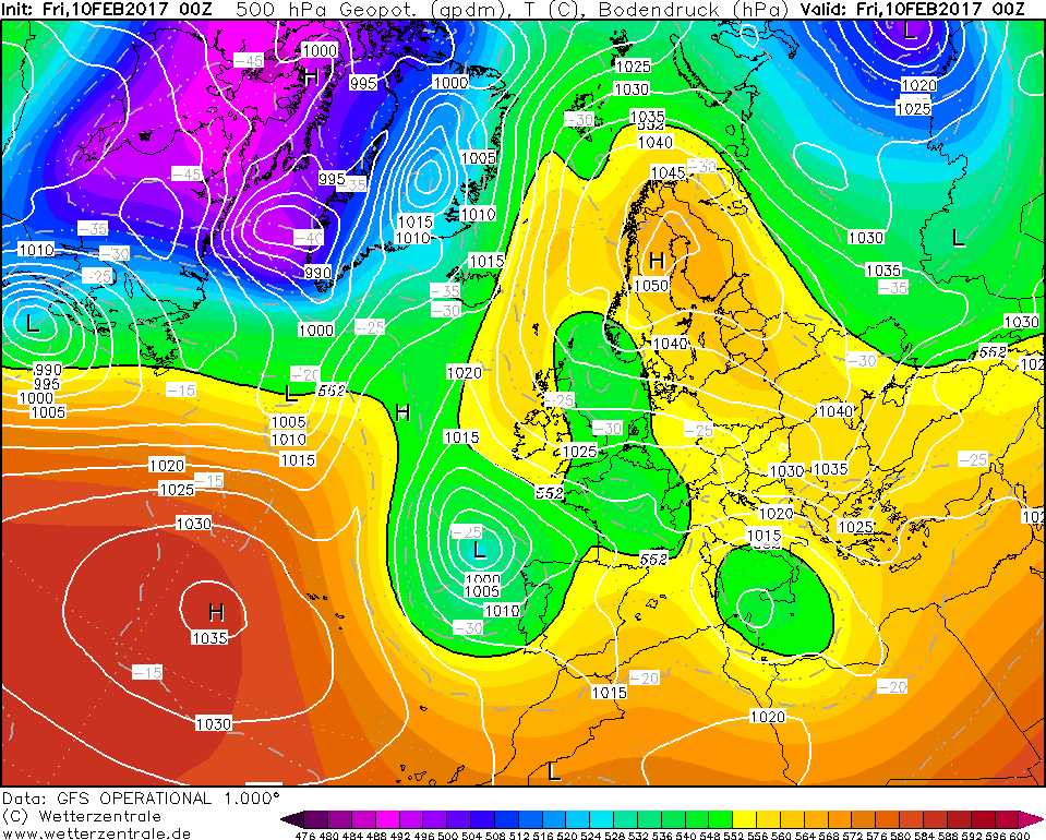
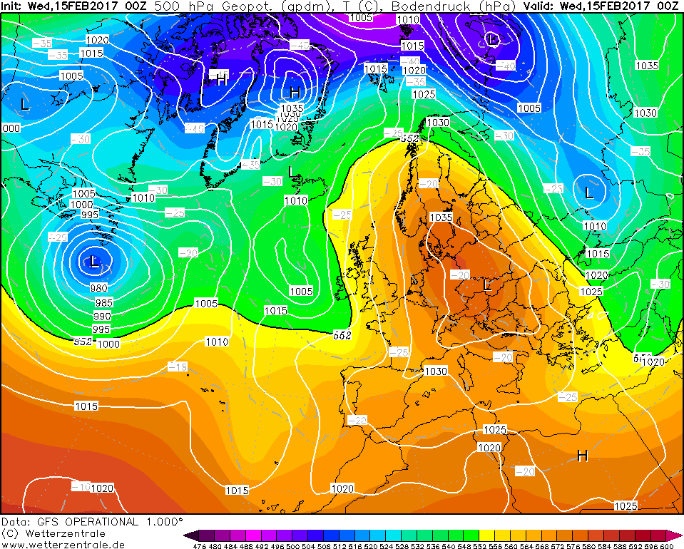
For example, looking at the chart below for the 10th February 2017, you would have thought we were on the brink of a cold spell from the east!....
Scandy High, low to the south, great!
However, a few days later and all is gone!
High sunk with Atlantic trying to storm through.
Its possible if last year was e-QBO, we might have hit the jackpot, really, But hey ho, that's only my analysis.
This year is e-QBO, and with winds high up in the strat becoming more -ve, we might have shot this year.
Let's just hope that everything fits together and we can at least get a snowfall this winter.
Heres to hoping!
-
7
-
-
Looks like some posters are coming out of their Summer hibernation!
Anyway. Hopes for Winter 2016/17? Cold, snow, ice, the full works really. Something akin to 2009/10 or a Dec 2010 repeat, would be wonderful
(Though highly unlikely as it may be).
A little advice before we all get hung up on model runs....
Don't take em' all too seriously, especially the long-range forecast ones.If I remember straight, we're GLOSEA5 banging on about HLB in the G-I-N corridor and the Met Office banging on about North-easterly winds prominent through winter from their contingency planners forecast?
Look how that winter panned out!
OK, there was some cold temps due to a high sitting over the country through some parts in Jan, but nothing to the extent of what some forecasts thought we would get.
My point is, don't take the models seriously, not until full cross model support.
Here's to a good, cold, snowy winter! Hopefully, we'll hit the jackpot this time around!
-
8
-
-
Snowing in Central London!!!!!
-
2
-


 ).
).


 (Though highly unlikely as it may be).
 OK, there was some cold temps due to a high sitting over the country through some parts in Jan, but nothing to the extent of what some forecasts thought we would get.
Model Output Discussion 01/09/17
in Forecast Model Discussion
Posted
Latest from Gav'sWeatherVids on the upcoming (Potential!) cold spell. Taking a look at the ensembles on meteociel!")
A Good watch with a pretty balanced summary of where we are.
Enjoy!")