


Snowy Easterlies
-
Posts
796 -
Joined
-
Last visited
Content Type
Forums
Blogs
Gallery
Events
Learn About Weather and Meteorology
Community guides
Posts posted by Snowy Easterlies
-
-
looks a better run so far out to 108 high looks stronger
-
Speak for yourself. This isn't 'snow watch!' The synoptics being shown are rare and unusual and as myself and many others have pointed out would have been thought of as the stuff of dreams a mere few years ago. The stonking runs shown earlier this week were pure model porn and not to be taken as gospel. Potential for sub zero maxes and pale winter sunshine with sprinkling of snow are an order of magnitude better than a mucky and mild continuation of autumn. The 12z will bring changes and hopefully a little something for everyone!
that is true the actual synoptics are rare for december, but if the GFS verified it would still be just dry and cold for most, i had a frost the other night in completely different synoptics its isn't always mild and zonal in december like people seem to think, i can recall many anticyclones spells or high pressure over sat over us in december with frosty nights but those synopitcs didn't look anything special but we still got cold days and frost
-
No it's not, next week would still become very cold and blocked and then there is a risk of rain turning to snow as it pushes into the cold air entrenched over most of the uk. And it's only an op run and probably an outlier.
when we say downgrade we mean downgrade for snow from the easterly, yes it stays cold but most on here look for snow not frost and sunshine as that is not rare like snow is, the control run is very nice in deep FI though, yet another bite of the cherry perhaps

-
We all want snow and blizzards, but personally cold and dry will suit me just as well, anything but the nonstop rain is a big plus and that’s the way things look like shaping up at the moment.
cold and dry is not as uncommon as people think and the GFS shows cold and frosty weather, even in FI snow reaches the west but then it dies out, albeit it stays cold for a while longer
http://www.meteociel...&ech=192&mode=2
of course it will change but this is what the actual chart shows, and not the "potential"
-
Hate to admit it but I agree with you IB and im very nervous about the model output this morning.
One trend I have noticed over the years when the models are predicting E,lys is how the models downgrade the duration of the E,ly flow, becomes slacker, less cold. However what then tends to happen is we see last minute upgrades inside +48/+72.
I sincerely hope the GFS/GEM are overreacting to the SW off the Norwegian coast. If not then we are at risk of this turning into a cold spell that consists of being cold, dry at first with only transitional snowfall after.
As much as I like the latest Met O forecast for my region. Based on all todays outputs I already feel as though its null and void because I cannot see the snow shower activity that they are describing in their forecasts.
yes the met update is good but have they got that from old data ? because the latest UKMO will probably give us fewer showers
tbh i will welcome a return to mild zonal if we get no snow out of this cold spell, i am a fan of snow, not dry cold, heatings costing a fortune anyway thats for another thread
-
IB has. As he says, it is to do with ste SW coming out of Norway. This was only picked up by the output in the last 12 hours. It may still be there in 12 hours time but would you bet against it being gone?
i have no idea and won't answer that question, but i want to hear from a level headed poster and not from the blind faith brigade because even though i sound negative the clear fact is the GFS in particular is a downgrade in the shorter term and mid term with the blocking and easterly, i refuse to talk about next weekend and beyond now, im only interested in early to mid next week's easterly if there will be one
the ECM and UKMO give some sort of easterly but even they have toned it down a little, anyway best wait for more runs before i get too downbeat but im not getting my hopes up
-
Well that's not really correct is it as I just demonstrated in my previous post.
It's never as clear cut as -6c uppers from the east for snow. I went in to some detail about this a couple of nights ago but when you see the blues on the 500mb charts, that means the corresponding pressure heights are much closer to the surface. Where as usually minus ) 850 's are required to ensure the atmosphere is cold enough from cloud to surface for snow, this is not the case with a shallow flow from a freezing continent.
Anyway, small details in FI at the moment, and that's something I'm sure we can both agree isn't worth the speculation based upon one op run
SK
i don't really want to speculate on "potential" at T216 yet again, nobody knows what will happen then but that chart clearly shows the atlantic winning, and when i said milder i meant too mild for snow i didn't mean milder as in 13c plus the winds are coming from the south at 216 not from germany
i won't be suckered into potential at 216, nobody seems to be talking about the downgrade in the shorter term with the easterly, esp the GFS which removes a lot of the blocking
-
i didn't say the block had gone but the atlantic still crashes through and uppers clearly rise on this run, we can speculate all we like about potential undercutters but i just see the charts of what they actually show and i don't always have faith in just potential,
lets be level headed here, its wrong to say it will be mild by 216 but its also wrong to say that there will certainly be snow from that low, its deep FI
-
ECM is better than GFS at T144 and T168 but this phrase springs to mind, yet again
-
i can't decide whether the ECM is a downgrade or upgrade compared to yesterday's run, however its better than GFS up to T168 as blocking is stronger
-
East of England
Forecast Summary
Outlook for Sunday to Tuesday
Becoming cloudy and windy with patchy rain during Sunday. Monday and Tuesday, becoming very cold with bright spells, but also with sleet or snow showers, some heavy, leading to accumulations.
update from the met office, is this based on yesterdays UKMO or this mornings ?
-
Anyone crying into their cereal this morning check out p4 from GFS ensembles, that will cheer you and give you a foretaste of tonight's pub run! - maybe
control run looks nice too, how many bites of the cherry do we need ?
-
It does seem like we can't get the truly interesting Synoptics the right side of t90. This has been a downgrade but it's only a couple of runs. It might be a trend, it could be the GFS going off on one.
I'm not remotely excited or even thinking about next weeks potential yet anyway. Even if we get full model consensus, widespread bitter has never got closer than the t120-t144 period and even if it does, we have all sorts of dramas, including SW's, lows, highs and the rest of it.
Get it to t72 and I'll be happy. Until then, many more dramas, swings, downgrades, upgrades etc to come.
true, but the downgrades start very early on, if there was a big downgrade at T168 i wouldn't worry as much, but the the downgrades start at T90, who knows maybe there is time for upgrades again but im not optimistic about it, i bet on the 12z we see great charts at T200 again lol
-
I think a lot of us will have learn't a lot about model watching in this past few weeks, which is not to believe a thing the models show post + 144 , makes you wonder why they even bother going out to +384 really .
I feel like I have just stumbled across a lottery ticket I had bought previously and misplaced, checked it, only to find out it was one of the winning tickets (all 6 numbers), called Camelot only to find it expired yesterday = GUTTED :-(
yep but we always get sucked in and we will never learn, people can bang on about this being a cold run still, but what we are after will be in short supply until a potential low hits us next weekend and no way am i hanging my hopes on a potential undercutter which is at T192
GEM is also a downgrade from yesterdays run in the short term, but at T180 the blocking comes back over scandi, but again, im not falling for it, as its FI
lets hope the ECM saves us
-
UKMO T144 OK. GOOD
http://www.meteociel...=144&carte=1021
AND GFS Salutes Steve Murr - The block holds into low resolution with undercut and undercut and undercut.
AND I WILL TAKE THE WHOLE OF THAT 00Z GFS FROM START TO FINISH ( Probably will never say that ever again)
yeah its a cold run for sure, but you can't deny the easterly has disappeared and blocking is far weaker on this run, compared to what was shown over the last few days, UKMO is not bad but what would happen after T144 ? now we wait for the ECM, best to judge after that
-
that low just seems to die out when it hits us at T204, i refuse to get excited about potential for that though, there is a clear downgrade in the short term, but as i said it somehow stays cold on this run well into FI
UKMO better than GFS but still a downgrade on yesterdays run IMO
-
have to hope the UKMO don't follow the GFS now, the GFS reminds of the last let down a couple of weeks ago when blocking wasn't as strong as people thought and the atlantic crashed through, i wouldn't say this was only one run though the 18z started the downgrade early on
PW we were let down a couple of weeks ago remember lol
Edit it somehow stays cold though on the GFS even though blocking is blasted away
-
do i laugh, or do i cry, GFS is a big downgrade in the short term
-
agree the 500mb charts flatter to deceive, where is the strong windflow for next wed and thur? some places might get something on tues when the flow is stronger, as for next weekend im not going to speculate on that right now, quite often these lows end up further south and we end up staying cold and dry.I was one of the first to say last week that the failed Easterly may not happen.
Guess what ? It didn't happen.
Next week will be bitterly cold but dry away from favoured coasts.
That's my opinion so rather than jump down my throat lets wait and see what does happen?!
I also think that the breakdown is going to happen Sat week
Some dont agree so can we wait and see what happens there too.
EDIT - COLD!! And yes in the meantime we can all have fun building
frostmensnowmen -
Odd looking T192, I assume it will bring back the Atlantic by T216.
you said there was no way back for the atlantic a minute ago
-
-
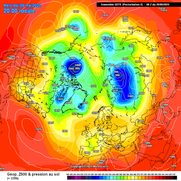
http://modeles.meteo...h-2-1-228.png?0
could this happen by next weekend, this chart is good, but it would be so typical if we ended up with a west based NAO after all this talk of a scandi high
-
GFS is more blocked than UKMO, is the UKMO good flow looks a bit slack at T144
-
amazing run so far, atlantic is held back even further at T150 on this run


The Winter emotions and moaning thread
in Spring Weather Discussion
Posted · Edited by Snowy Easterlies
roll on summer, actually scrap that because we will be chasing heat waves in FI that don't come off, however warm sunny days are still far more common than snow at least in this part of the world
shortwaves are the killer of snowy synoptics, whats the killer of nice summer synoptics not shortwaves surely ?