


jvenge
-
Posts
1,641 -
Joined
-
Last visited
Content Type
Forums
Blogs
Gallery
Events
Learn About Weather and Meteorology
Community guides
Posts posted by jvenge
-
-
-
Anyone got MOGREPS output?
2 minutes ago, Nick2373 said:Ten days away could change? FI I think Jules.
It's changed enough If it keeps changing I'll be having a BBQ on Christmas day.
-
1 minute ago, daz_4 said:
Jules is going to have a heart attack this morning. We went from beautiful winter nirvana in Central Europe to SW express over Christmas. Classic
Yep. Minus days to double digit plus temperature in 24 hours
-
Just now, CreweCold said:
Yep and you and I both know that once the erosion starts it very rarely stops.
You're telling me - ECM in one OP run yesterday went from a minus day Christmas snow event to +10 degrees
-
 1
1
-
-
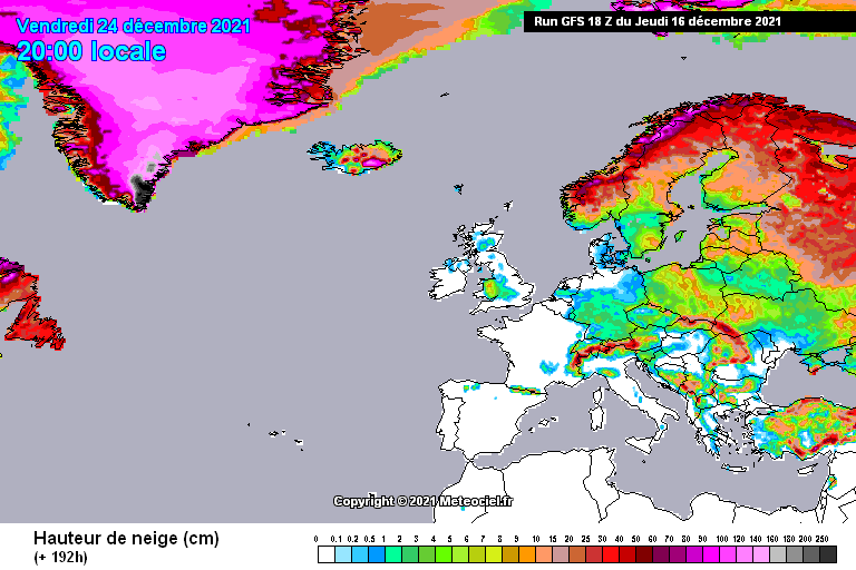
1 minute ago, MattStoke said:
Yes, yes I know GFS snow charts at hopeless, particularly at this range, but this merely shows that actually that turns out to be a very wintry Christmas Day on the 0z.

I always find it interesting how different websites showing the same model output get to different things.

-
1
-
-
2 minutes ago, Ravelin said:
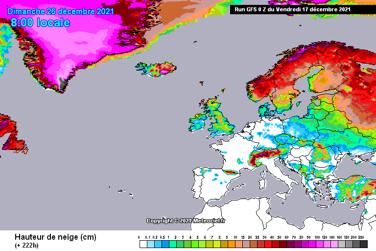
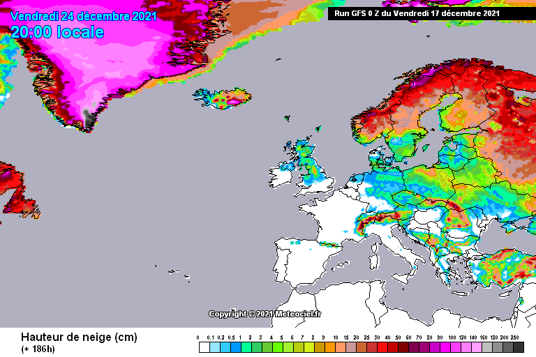
Way too much IMBY going on as looking at the snow depth charts, for what they are worth, the 0Z GFS is an Upgrade for most of the UK on Xmas Eve if its snow you want.
Perhaps vs the 18z, but a downgrade from the 12z. Also, heavy snow just over higher areas (Pennines mostly for England). I doubt what is shown for lower areas would settle.
-
For the UK dwellers, the latest GFS run confines heavy snow to the Pennines on Christmas day and Christmas eve. I'd also be doubtful the snow showing for lower areas would settle. Yes, I'm aware that it's a long way out and bla bla bla, but it's just what the output shows presently.
-
I hate the run for me, but I realise it shows something nice for some people.
-
3 minutes ago, The PIT said:
Still all in lala land so not getting excited yet watch the ECM now jump ship.
To be honest I wouldn't mind a slightly different path shown. The GFS 12 gives me snow for Christmas morning, but much like the ECM from this morning, any slight downgrade would scupper it. The 6z gave me deep cold but no chance of snow. The 12z still coldish and then deeper cold towards the end of the run again. So when I'm hoping no downgrade happens around 9-10 days out, I usually know which way it will go
So, hopefully the ECM and ENS can show a more reliable path.
-
13 minutes ago, B-C said:
RAMP -
If we still see something remotely like this into a 'reliable' timeframe.....
 Cold towards Christmas, then what?
Then nice for those who like that kind of thing But considering 85% of the posts in the main output thread, I don't think this can be called a ramp.
-
Just for fun.
-
2
-
-
1 minute ago, jules216 said:
The milder for SW UK the better,. Means more members with GFS solution like this
I agree with Jules..
ECM Op this morning would deliver snow for me on Christmas day, but it is so borderline I could also end up with 7 degrees or so with a slight change.
-
Just now, That ECM said:
I said yesterday I would give it 48hrs. I will still give it until tomorrows 12z. Gfs has given me the hump but Ukmo shows it’s not done.
UKMO looks tantalising initially, until scrolling through the GEFS and realising it can still go wonky after and quite quickly.
-
1
-
-
1 minute ago, Mark Smithy said:
Good morning all. I don't normally go for this idea that the models have it wrong and you're a brave person if you bet against the GFS. However, the 0z GFS is a rather 'odd' run. The synoptics look strange to me. There's a large period of nothingness, a void, in Christmas week which just looks synoptically all wrong. You can't have 'nothing' happening when there's no controlling high pressure as such.
I 'think' the reason for this is that they are all struggling with the high pressure cell: how established it will be, how strong it will be, and where it is moving. Specifically they are don't know how to deal with the Svalbard High, should that materialise. You can see what happens if a Svalbard High does emerge as per this GEM chart.
It's a pretty rare setup and that's why I think we're seeing such divergence at the moment.
You may be right, but it isn't just the GFS Op. It has plenty of support in the ensembles (some worse). Even the control isn't exactly a banker and that shows one of the more favourable outcomes (for the UK anyway). The mean is now at very weak highs north west, jet south of the UK. Cool, but not cold. I think what the GEFS show quite well is that getting heights into Greenland is not guaranteed to then bring a favourable outcome.
-
GEFS mean at t264.
-
1 minute ago, weathermadbarnsleylad said:
Control run looks good at l80hr / Greenland high / the opp will be an outlier I reckon
/ nh view control at l80 nice cold pool to the ne on its way.
Quite a few of the ensembles manage to get high pressure into Greenland, but they then do very different things with it.
But the Op isn't an outliner. Quite a few ensembles looking similar to the Op and Control also.
-
2 minutes ago, Steel City Skies said:
There's a lot to be resolved Jules. It's a mean chart at 252hrs... not something to be confidently called (though I know you're a mildie for us). There was potential, there still is potential, not much has changed on that front and the only takeaway we can get from such a comparison is that - and I'll finish where I started - there's a lot to be resolved.
Jules is a cold weather fan, not a mildie. He is just a little more realistic/objective than some. The GEFS mean and members do show a less favorable outcome than the previous run.
For the UK there are more challenges. Even if the Atlantic doesn't come through, the models show that the most numerous option after that is high pressure or ridging over or around the UK. In any event, a full blown easterly is not the form horse on the GEFS this run. And looking at the members of the GEM from yesterday it also wasn't.
Maybe it changes the next run or/and the ECM hints at something better.
-
3
-
-
2 minutes ago, jules216 said:
Spot the difference
Hi Jules,
Nice to see you again.
The mean is messy because of some members showing a weak ridge staying over the UK and others showing the ridging expanding more over Europe. Combined those two quite different options give a rather dull looking mean.
There are still plenty of others showing a favorable placing of the ridging or in some cases broken off high pressure.
But it's true. Less cold outcomes for us on this suite vs the previous.
-
3 minutes ago, northwestsnow said:
Ukmo 168
Can the block collapse into Scandy ?
Trawling through the ensembles and looking at the mean from the 18z ECM ensembles I doubt high pressure goes into Scandinavia on the first attempt. But it's possible I suppose.
Some kind of riding over the UK and reaching towards Iceland and perhaps on into Greenland seems the form horse. It would be nice if the models could make a decision on that today.
But looking at how things are playing out I'd say for the next month or so there are going to be many bites at the cherry. Even the UK can't miss out on each. Can it?
-
EPS Mean not so different to the 12z yesterday, out to day 10 or so. Slight shift west for the high.
Lots of options in the clusters, one suspects. Although if this potential cold weather doesn't hit western Europe, I'm just wondering about a split in this high and part of it sitting over Western Russia and the other part ending up just below Greenland. Getting quite cold out that way. Not exactly a classic Easterly, but it would certainly deliver.
Of course, that's probably at least 15 days away and a lot could happen in that time.
-
1
-
-
1 hour ago, knocker said:
Not too bad
Yep. EPS not really with the op this morning. EPS not keen on the high shifting to Iceland and then onwards, rather keeping it north east of the UK.
-
The good thing about accuweather is that you can see how their previous winter forecasts fared. Still, they at least stick their neck out and do it.
-
1
-
-
From an analog point of view - Winter of 2002-2003 and 2009-2010 are quite close to current conditions and forecasts.
It won't take too long for you to realise they delivered quite different things
-
From what I know, as we approach the solar minimum of a solar cycle, interactions with the stratosphere can influence the polar arm of the jet stream. (from memory I think it is something to do with ozone). This seems to happen irrespective of ENSO conditions. There have been a few papers on the subject over the years. A quick google finds this from Nature https://www.nature.com/news/2010/100414/full/news.2010.184.html
Influencing the polar arm of the jet will undoubtedly influence the temperature of Europe. It is pretty much how every cold spell comes to Western Europe. You can constantly observe this. That happens to Europe irrespective of what the co2 concentrations are. EUROPE, I said.
But we almost go onto another topic now. Because a solar minimum within a solar cycle is one thing. This is widely accepted. It is not yet clear if this year will be the minimum or if it will be next year.
The issue is then people tend to try and predict how future solar cycles will be and it gets quite murky. The last solar cycle (or the one we are in) is a long way from a Maunder Minimum type scenario. In a Maunder Minimum type scenario you would have every winter (just about) giving you what a current solar minimum does in the 11 year cycle. There isn't anything assured that SC25 will be lower than SC24 and even if it was, that it would be low enough to influence each European winter. Observational evidence of the current cycle (recent history shows it to be quite low) would point that it isn't low enough to radically change winters outside of the usual minimums. Put simply, a weak SC24 (by recent historical standards) wasn't weak enough.
You will find different scientists predicting different things for the next solar cycle. Quite honestly, I'd say its pure speculation to say another Maunder Minimum is imminent. So, even if you got a SC25 weaker than current SC24, it isn't clear if it would be sufficiently weak enough. Added to that, many scientists will take a punt on it being a little stronger than SC24.
In general, in the last thread especially, the thread became overwhelmed by people talking about different subjects (past, current and future) that it became a mess.


Model discussion - hunt for cold - Christmas countdown
in Forecast Model Discussion
Posted
Well, if you wanted to play the odds, ECM and Ukmo. Didn't the ECM just set a new 5 day accuracy record?
But ultra fine margins, so I wouldn't say it's a very safe bet.