


Mark Bayley
-
Posts
3,167 -
Joined
-
Last visited
-
Days Won
2
Content Type
Forums
Blogs
Gallery
Events
Learn About Weather and Meteorology
Community guides
Posts posted by Mark Bayley
-
-
5.2c please
")
-
 1
1
-
-
4.2c please
-
On 23/01/2016 at 10:54 AM, LeeSnowFan said:
Good Morning!
It really has been a poor winter "snow" wise for us , We have about 5 -6 weeks left for it to turn around and hopefully give us something to enjoy! otherwise it will be a pretty rubbish 2015-2016 winter
Probably the worst winter i can remember. Looking back through my albums I have at least seen two good snow events each winter. Although we had that snow the other week, it rapidly melted.
Although my expectations are still tainted by the amazing winters of 2009/10 and 2010/11
2009/10
And the most beautiful of all, 2010/11..
Still, we have February and March to redeem this dismal winter. I've witnessed decent snow events up and till April in my area, although sadly as we progress towards the back end of Feb and into March snow cover retention becomes ever more difficult
-
2
-
-
A definite signal for the core of lower heights over Greenland to transfer towards the European side of the Arctic. This is evident in the ECM and GFS ensemble means >
However, the GFSE seems to keen to later transfer low heights back towards Greenland, likely scuppering an sustained cold spell. Although i'd suggest folks have a read of singularities recent posts. I think they sum nicely the risks but also cold opportunities as we progress into February.
-
1
-
-
5 minutes ago, Winter Cold said:
Hi. Its melted a little yes, but still a covering on most surfaces. The side roads like mine are slushy but the main road is clear now. About an inch left mostly on grass and pavements etc.
Im hoping that the very slow melt has stopped now as were heading into night but looking at the forecast its showing mostly cloudy and temps around 0c. Was hoping it woud be clearer and get lower to freeze it.
As you say, just have to see if anything pops up tomorrow. Might just be a few flurries again like this afternoon
So a slight thaw, having lower elevation I reckon a bit more of a thaw where I am! As you say temperatures struggling to get much below freezing tonight, especially with cloud cover. I shall not be too disappointed if it all goes. Hopefully a nice east or north easter in February!
-
1
-
-
21 minutes ago, Winter Cold said:
will do! on their way now
EDIT: your welcome
Has much of your snow melted? Hoping to see some Tuesday morning when back! Don't think we'll get much tonight or tomorrow, although remnants of the precipitation from the west may be enough to lead to a few flurries (should they make it)
-
So the one day it snows is the day I go to London! A covering at my house according to some pictures. Good see others getting a covering too :). Not sure much will be left Tuesday sadly (my end). Hopefully a few more snow events before winter is out!
-
1
-
-
32 minutes ago, Dreamnine said:
No real (deep) cold in sight according to the models that I can see. Southern England will be 5C and raining. Here it will remain at 2 to 4C maxima a day which it's been the past week. But expect 8 to 9C widely next week.
I can't remember our last double digit maximum. But 10C quite likely in Edinburgh next week
Looks quite cold on the ECM. 3-5c across the south of the UK (i.e. south of the midlands) till Sunday, 0-3c the Midlands north. Colder still on Monday and Tuesday, with possible ice days further north! Very cold at night, with minus double figures in the North over the weekend and early next week. Wednesday and Friday maximum temperatures in the south are about 6c (9c in the south west), although tbf it does show double figure maximums on Thursday! Not a deep freeze, but notably quite cold with snow for some. I'm willing to wager that 'milder' temps shown Wednesday onwards continue to be pushed back... (i.e. the ukmo solution)
Also, as stated by Steve four posts down, the ensembles seem keen to retain the cold longer!
-
4
-
-
GFS 0z was marginally better for snowfall Weds-Friday, with colder uppers. The 6z restricts snowfall to the Pennines Wednesday night, or at least accumulating snowfall.
ECM also restricts snowfall to the Pennines, although has a band of precipitation scraping East Yorkshire and Lincolnshire Friday night, leading to a covering across the North York Moors/Lincolnshire Wolds
-
2 minutes ago, chionomaniac said:
That is not my experience - the H500 anomalies sen for the Atlantic sector over the next few days are very similar to the ones predicted over a week ago and are verifying well. At that point we didn't know what was to come after but now we do. I thought the black hole runs were individual runs and not the whole ensemble so that comparison may be unfair ( I didn't ever post them so not sure 100% on that)
Yes, it these charts I think snowmad is referring too, which are anomalies for individual runs. They've been posted a few times, especially when the ECM was going all out for a Greenland high!
http://www.meteociel.fr/modeles/ecmwf.php?ech=72&mode=101&map=0&type=0&archive=0
-
The ECM has covering of snow across all of Yorkshire (although sadly not Lincolnshire). I never really trust snow cover charts though. One to watch as head nearer the time. I favour a high ground restricted snow event at present though
-
1
-
-
FWIW by Friday morning the ECM has a covering of snow from Yorkshire Northwards. Nothing more than a scattered dusting further south. This is similar to the GFS. where high ground in the north is favoured for a possible snow event Thursday night. Its not worth going in depth at this stage, but one to look at more closely as we near Thursday (if snow potential remains)
-
1
-
-
3 minutes ago, *Sub*Zero* said:
12z UKMO not as good as the 00z which had strong Greenland heights, but it still looks good regardless.
I suspect the UKMO would go on to produce a weak easterly, with the high eventually positioning over the UK, prolonging the cold (much like the GEM). That is probably the favoured solution as it stands
-
4
-
-
19 minutes ago, The PIT said:
12oz reduces the snow chances even further unfortunately with unfavorable dew points etc when any PPN is shown.
Yeah, does look very marginal away from quite high ground. I'd think the western side of Sheffield (crosspool, fulwood etc..) would even struggle. Still, its a few days yet. Better waiting for it come in the range of the high res models.
-
7 minutes ago, snowangel32 said:
Has anyone got a link for the verification stats for the GEM suddenly it's my favourite model lol.
Here
http://www.emc.ncep.noaa.gov/gmb/STATS_vsdb/
GEM is fourth, ECM ranks highest at all days, UKMO and GFS very close (0z 500hpa)
I find the GEM flips around significantly, certainly when comparing the daily runs
-
2
-
-
Some agreement between the GEM and UKMO at T120. The GFS so far on its own!
-
22 minutes ago, Mark N said:
ECM text forecasts can be found here for locations - http://www.yr.no
@Mark Bayley- ECM snow charts at http://www.wunderground.com/wundermap/
Cheers Mark. The ECM charts posted by subzero are available on accuweather, around £12 a month. Can report the snow accumulation on the ECM is pretty good by the end of the run. A covering everywhere. The feature crossing the UK at T96 to T120 delivers a decent snow event to Yorkshire, Lincolnshire and central/east Midlands with a dusting into East Anglia and the South East (a 1 to 3inch covering, not that snow accumulation charts should be trusted, in the east midlands and yorkshire). Dewpoints look marginal however, although hard to tell with the chart graphics. Dew points drop as the feature clears south eastwards, so snow on the back edge where sleety at first. Rather too much detail for a chart certain to change. However, it does highlight some good opportunities in the next week!
-
3
-
-
11 minutes ago, ukpaul said:
Icelandic Met use them, you can see most of the UK on these charts -
I am sure I remember a site where you could view precipitation type from the ECM, freely. I've lost all my links sadly. I think it was this one Cheese rice posted back in December?
-
1
-
-
The GFS develops a shortwave (the mini low), phasing with the trough in the Atlantic at T96 onwards. Thus the HP ridge collapses. In contrast, the UKMO does not do this, thus the ridge is sustained. A good T144 chart, and should pronlong the cold. Will be interesting to see where the ECM goes. Sods law would suggest im better placing my money on the GFS. I live in hope though!
Its been so long since i posted i have forgotten how to embed images!
Edit: Finally hacked it
UKMO, phasing of troughs; GFS troughs phase/ridge collapses
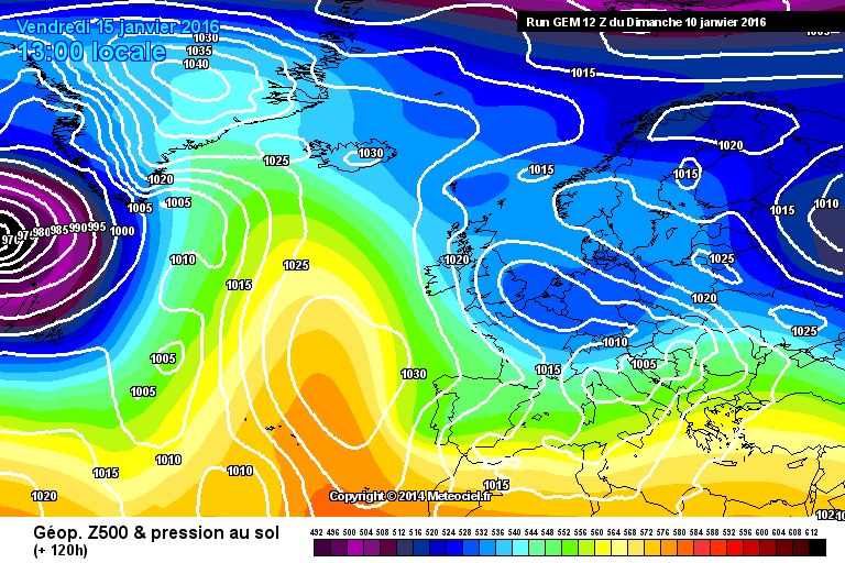
GEM supports the UKMO, as others have noted. However this model has been flipping around all over. HP collapses over us towards the later stages of the run. Should cold sustain, this is the most likely evolution
-
4
-
-
3.2c please
-
1
-
-
-
8.4c please
-
10.1c please
-
1
-
-
12.9c please
-
1
-


April 2016 C.E.T. forecasts
in Spring Weather Discussion
Posted
8.1c please