


Frank Trough
-
Posts
821 -
Joined
-
Last visited
Content Type
Forums
Blogs
Gallery
Events
Learn About Weather and Meteorology
Community guides
Posts posted by Frank Trough
-
-
3 hours ago, knocker said:
When discussing big storms my mind inevitable goes back to the 19th December 35 years ago. Repeats we don't need so let's hope not much comes of this/
was that the Penlee lifeboat disaster?
Certainly looks lively Saturday night on the 06z. I've got next week off to dismantle my shed, move it 5 meters (where it should have been in the first place) and rebuild it. Perhaps there won't be much to rebuild at this rate.
-
17 minutes ago, Frosty. said:
Yes Nick it was tragic and pathetic wasn't it..anyway, signs are good for plenty of cold air from the nw from later next week. And its not all doom and gloom before then either as we will see occasional frosts and even some freezing fog.
It wasn't even a good winter in deep FI or deep among the 18z ensembles at t+384.
In the meantime, the colder flow is creeping nearer and nearer the "reliable timeframe" again.
http://old.wetterzentrale.de/topkarten/fsavneur.html
Genuinely, quietly excited now.
-
 6
6
-
-
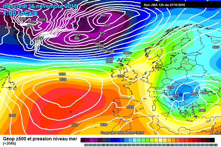
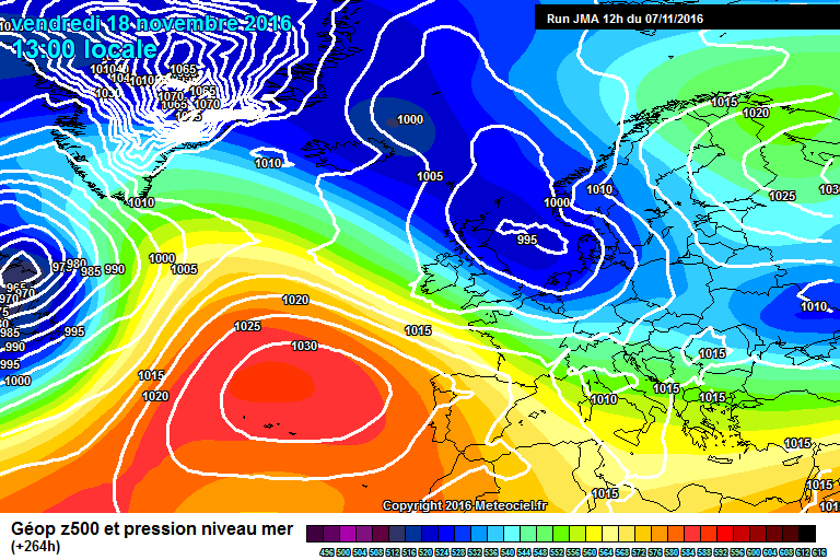
18 minutes ago, Catacol said:
From this :

to this in pretty quick time
So very different to recent years. Atlantic has no depth to its umph - blocking very much the form horse. Accepted this is medium range output, but to see depressions forecast to fizzle out like this in November is the sort of pattern we snow seekers have been anticipating for several years now.
as a note of caution, those charts are still 10 days away? Let's hope we get a smooth transition to the more reliable like in 2010.
*edit* my screen was covering your last sentence!
-
11 minutes ago, Catacol said:
I guess it depends where you are. For those in the south and west a northerly rarely delivers though a cold NW stream over the Irish Sea can bring snow showers. However the best setup down here is either a trough moving in on a SE feed from a low pressure sitting under a Scandy/Russian high (as per Feb 91) or a proper warm/cold collision event causing stalling and heavy snow. I'll never forget Feb 96 in that regard.
Both require high pressure in situ. As you live in Poole I doubt you would get much from a mid atlantic or Greeny ridge / scandy trough scenario which I assume is what you are hoping for instead?
A little ice-age is probably what we need down here to avoid the dreaded "rain on the coast" scenario. December 2010 did deliver snow to this area but nowhere near as much as other areas in the south. A stonking proper easterly with genuine cold uppers and a sliding channel low would be what I would I pick personally IMBY.
-
2
-
-
40 minutes ago, swilliam said:
The last time I can remember significant cold at the beginning of November was 1980 when there was snow in the channel islands and -8 uppers in SE England
I can't remember if it was 1993 or 1994 but one of those Novembers (I think) had a sort of blocking holding pattern with little temporary easterlies before we got a full blown affair later in the month. I think 1994 now if memory serves.
-
I can't believe how benign everything is! I can't be the only one who is missing a good autumn storm just a little bit? another mild/warm even Halloween to come:
didn't we used to get the odd frost in October?
I really hope we end up with all this initial blocking ending up in the right place so we get an early taste of winter. I can't help feeling that all the while the westerlies remain absent the chances of them returning (for they surely will) for the start of winter slowly rises.
-
4
-
-
On 03/02/2016 at 1:57 AM, iapennell said:
"May 2016 is certain to be wet and chilly with few warm spells even in the South: Prevailing stiff West or NW winds will keep temperatures on the cool side and frosts will continue to threaten gardens in Scotland and the North with clear nights between frontal bands. I am confident that May will be like this because the upper Westerlies will be in a four-wave Pattern and with cold cold water in the NW Atlantic one of these upper troughs will be close to Britain. "
things don't look especially "chilly" for the time being? You are still expecting a shift to west/northwesterlies and below average temperatures?
-
7
-
-
15 minutes ago, Costa Del Fal said:
20c was reached yesterday in Porthmadog , Wales. England has yet to reach this mind.
Edit: Sorry Nick, just saw you beat me to this lol
ha ha! yep, that completely undoes everything I posted. I thought the top figure was 19.5 at Porthmadog which is what I heard on the radio. Clearly they were wrong.
-
On 06/04/2016 at 4:51 PM, iapennell said:
The weather stats for March 2016 are in, about 0.7C colder than normal for the South and also wetter than normal (but not by a wide margin). Scotland only slightly warmer than normal but also (surprisingly) a bit drier than normal. I predicted March to be wetter and a little colder than normal, but with these anomalies being stronger towards the north-west but I am confident that going into April my original predictions for continued chilly westerlies and NW winds will hold (here in the North Pennines this afternoon temp. is 4C and we have stiff west/NW winds and showers of sleet and hail!). I will let you judge me on my forecast so far and then as the season further unfolds.
If it is any consolation I did predict a fine spell mid-to late April for most of the country (with Scotland and far NW missing out)!
I think the fact that 20c isn't going to be exceeded anywhere now before May is quite interesting in itself. First time since 2006 and, according to Trevor Harley, before that you have to go back to 1983. So not a common occurrence in recent times at all.
What is now interesting me is how long into May we might have to wait! took until 25th may in 1983 which is the latest date recorded.
If Ian's forecast here is right we might be challenging that.
edit - I tried to quote stargazer rather than Ian - don't know why that happened.
-
2 minutes ago, Relativistic Sting Jet said:
Surely 2013 did it? I think many places did it last year.
20c was definitely passed somewhere before May in both 2013 and 2015. April last year was warm and sunny in fact it was the third sunniest and third warmest in the last century. Apparently!
-
I'm still left wondering that if we don't manage a 20c somewhere next week (as almost advertised by the GFS) whether we might go all the way through to May without doing so? Certainly none of the modelling for the last third of the month suggests we will even get close.
I think I'm right in saying that would be the first time since 2006? And prior to that 1983?
-
28 minutes ago, stodge said:
The likelihood of a colder than average spell in April has been well advertised and would echo the post-El Nino winter of 1998. GFS has however moved away slightly from some of the really cool options but there aren't many, if any, warm options on the 06Z Ensembles at T+240.
Basically, it's a toss-up between cool and dry under the influence of HP to the west or north-west or cool and wet with LP over us or close by to the east or south.
That's emphatically not to say we won't eke out some decent days - the last couple of days have been good for those areas which have missed the showers and I think early next week we could well see tho or three quite decent days but the warmth many on here want just isn't there (maybe 15-17c next Wednesday at best).
The two crumbs are first GFS 06Z OP in deepest FI turns much more settled and warmer but that's a very long way off. Second is that May 1998 was very warm (13.1c) and dry with 25c breached regularly so we could see a sudden and dramatic turn after any cooler spell.
It is only April - I think expectations are reasonably tempered aren't they? If it was June I could understand people wanting a bit more than 17c and sunshine - but in April? I think it's been a pretty average mixed bag of a spring so far and it looks like continuing in that vein over the next 10 days or so.
-
3
-
-
1 hour ago, Weather-history said:
Oops, big mistake there. Summer 1983 was a very good summer, it certainly not what Matt Hugo is trying to make out it was.
"After one of the strongest El Nino events in years through this past winter, of which is comparable to the likes of the 1982-1983 and 1997-1998 El Nino’s, there is some correlation and connection that supports a generally cooler and more unsettled summer for the UK, particularly when there is expected to be the development of a La Nina, which now seems to be likely as the rest of the year progresses. Indeed, both the summers of 1983 and 1998, but particularly 1998, were often unsettled with low pressure systems and unsettled conditions never too far away from the UK."
that is bizarre. According to Trevor Harley June was cool and cloudy (but dry) but here is a quote about July '83:
"The hottest of the century (19.5C), and indeed the hottest month since records began. Also mostly dry and sunny, but with some severe thunderstorms. A ridge of high pressure extended from the Azores as the month started. The temperature reached the magic 32C somewhere in the country every day from the 12-16th, and the average daily maximum at Heathrow in the month was 27.6C. There were 17 consecutive days above 27C (80F) somewhere in the country between the 3rd and 19th, and 22 days above 27C in total; the temperature exceeded 21C somewhere in the country every day but one. The highest temperature of the month was 33.7C at Liphook (Hants.)"
August was also hot and dry in the main.
-
3
-
-
18 minutes ago, stodge said:
Singularity expresses it very well in his previous and the obvious reaction to today's output, so far, is "if only" for coldies. These charts in December/January would have this site in meltdown. The GFS 06Z OP keeps us on the cool side throughout after a brief warmer snap at the weekend.
THis is the critical moment for the synoptic evolution. The first HP wanders off east and declines but the second establishes to the NW and effectively stays there. The troughs to the south (the remnant of the current trough) and the north (from Iceland) force the HP back to Greenland and leave us in a N or NE'ly airflow.
ECM at 00Z is in a similar place though with the HP more dominant.
For fans of warmth, GEM 00Z offers a much better scenario but the critical thing here is GEM removes the Greenland heights very quickly. If GEM have called this right, kudos to the Canadian model and to be fair they've called this week quite well so far. This would be a huge shift for GFS and ECM but the GEM Ensembles have a majority showing this different evolution.
That is precisely what did happen in the winter wasn't it?! Except the extent of the HLB was massively overdone at range and never got anywhere near verification. I'm thinking that if we don't manage to manage a 20c early next week a la GFS 06z then it might be pretty hard to come by in the remainder of April IF the HLB showing today is anywhere near correct this time around.
*edit* the METO update today doesn't seem to favour any kind of N or NE'ly flow in the mid term from what I can see:
"High pressure is then expected to dominate for much of the remaining period, bringing a good deal of dry and settled weather, albeit rather breezy at times. Showery rain may move up from the near continent to affect southern England at times, and the odd shower may develop locally elsewhere. Temperatures generally around average, but with some chilly and potentially frosty nights, especially in the north.
Updated at: 1226 on Tue 12 Apr 2016"
-
2
-
-
8 hours ago, Eugene said:
Yeah shocking after all the hype, no warmth at all, charts for foreseeable are shocking too, with a massive greenland high forming and the risk of fronts stalling over the midlands, tired of this cool cloudy spring, the meadow near me is still flooded with more rain to come.
the outlook this morning is fairly grim it has to be said. I'm all for "getting it out of the way before summer" but I remember thinking that in 2012! I wonder how late in spring it will be before 20c is reached (unless that has already happened and I've missed it?)? Still, in 1983 it took until 25th May for 20c to be reached and July and August ended up being very hot. 2006 it took until may for 20c to be reached and again it was a great summer.
-
16 minutes ago, Lukey said:
I actually think it's rather horrible outside at the moment!! Cool, breezy, actually quite cloudy, and quite frankly not at all pleasant...
ha! i'll rephrase - it's quite nice out here at the moment! Although it certainly won't be after tomorrow for a while.
-
1
-
-
1 hour ago, coldcomfort said:
Really?? No real surprise to see some cold winter eye candy appearing in the models now the search for warmth has begun in earnest. Said it before and I'll say it again, UK..... undisputed world champion of right synoptics, wrong time of year, whatever the season.
I think people get a bit carried away with blocking in spring. it's common - much more common than in winter. The output at present is very "springlike" in reality (perhaps a bit wetter than you might hope for). The charts aren't showing anything "early summerlike" or "very late winter like" but they are undeniably "springlike".
It's the 5th of April. Personally i'd be happy to get a couple of below average months out of the way now before summer (I know it doesn't work like that really). We all know May will be a predominantly northwesterly month and be breezy and cool as is now the fashion.
plus it's quite nice out now.
-
1
-
-
if more time were spent discussing the output up to t+144 there would be an awful lot less guff on here. At least that has half a chance of verifying, be it mild, cold, wet, windy, cloudy...
So on that note, up to sunday the latest GFS offers plenty more usable spring weather to enjoy, with an emphasis towards the end of the week of slightly warmer temps more widely if it is on the right lines:
-
3
-
-
1 hour ago, Eugene said:
Yes nothing particularly warm on offer Banbury, feeling cold this morning with fog slow to clear, think many underestimated the coolness of the upcoming week with cool cloudy conditions dominating, looks a cool high not a warm one like in March 2012 with air sourced from polar regions rather than tropical.
Away from eastern and southern coastal areas it looks like double figures on offer each day (going by GFS)? signifcantly warmer than that for northwestern parts. I don't know if that is cool for most? Seems to me like spring to be honest.
It's lovely out today. I'd get out and enjoy it rather than desperately searching for below average temperatures TBH. There will be plenty of that from May onwards to "enjoy".
-
7
-
-
definitely a wintry element to the shower we are experiencing in Farnborough at the moment.
-
6 hours ago, johnholmes said:
Nothing in the anomaly charts to suggest what MWB infers, see links below
http://www.cpc.noaa.gov/products/predictions/610day/500mb.php
well, perhaps they're wrong? the azores ridge is going to be a player next week - to ignore it is folly. How much influence it has remains to be seen but the anomoly charts alone won't dictate that. Your faith in them is troubling.
-
3
-
-
2 hours ago, Man With Beard said:
Apart from the next 5/6 days, are we looking in the wrong direction here? Spring is within touching distance according to some of the ensemble output. Starting with the D10 means:
It's a close call between a slight northerly breeze and a south-westerly drift, I'd say. Uppers still slightly chilly but double figures in sunshine I'd think. And a closer study of the GEFS sees a proper breakthrough of the WSWly winds showing on many, for instance:
I'd guess 15C and sunny spells in the east on this one. And this isn't the warmest ensemble member either
ECM extended ensembles: cold has gone by the 10th, aside a slight frost or two
So it's not a one-way street for cold on the models - just saying...
I've been working on the assumption that any pressure build is being over done and that come next week the high will be supressed back more towards the Azores leaving us in a more northwesterly regime. However, it keeps cropping up. To be honest i'd love to see just some falling snow this week and then for something more spring-like to turn up thereafter but given the METO expectations for things to be generally below average overall out to early April i'm not holding my breath.
-
10 minutes ago, Purga said:
Before everybody gets too depressed the GEFS are still showing a majority of members (including the Op & Control) going for an extended colder than average period after a brief warm up next week.
Of course these can and do often 'flip' but at least the sign is there at the moment.
I don't know if just "colder than average" in march is going to set too many pulses racing if it doesn't deliver chances of snow. Of course up north it probably would give some chances in favoured locations so some interest there.
But if it's simply colder than average weather without snow you're after then you might as well look forward to May to August because you can bet we will get our fill of below average days/months in that period.
Surely these maxima for sunday in the southeast are a bit overcooked aren't they? It will still be February in a brisk north easterly?
-
2
-
-
7 minutes ago, chris pawsey said:
Amazing... out of all the charts in the world ever I would like this to verify... please??? A nationwide snow event for mothers day will get me out of going to see the mother in law
It's not quite nationwide...my mother-in-law would only have to do battle with a bit of sleet and then some cold rain to come and visit us.
-
7
-


Model Output Discussions 06z 04/11/16
in Forecast Model Discussion
Posted
But if you look far enough ahead any given chart could lead to cold. Nobody ever posts charts on here that preceded a horror show 3 weeks later but I bet you can find thousands.
In the meantime the other side of Autumn over the next few days and through the weekend. First real blow and could be pretty wet for many. Nothing out of the ordinary.